Cordillera Real Traverse - The Royal Trek of the Andes
The Cordillera Real Traverse is arguably South America's most spectacular high-altitude long-distance trek, a 120-kilometre odyssey that skirts the spine of the Bolivian Andes. Known as the "Royal Range," the Cordillera Real is a jagged wall of granite and ice that separates the high-altitude plateau of the Altiplano from the humid Amazon basin. This trek is not merely a walk; it is a sustained high-altitude expedition that remains almost entirely above 4,000 metres, crossing numerous passes exceeding 5,000 metres. It offers an unparalleled window into a landscape of turquoise glacial lakes, massive hanging glaciers, and the resilient Aymara culture that has called these high valleys home for millennia. Unlike the more crowded trails of neighbouring Peru, the Cordillera Real Traverse offers a profound sense of isolation and raw wilderness, where the only other travellers you are likely to encounter are local llama herders or the occasional Andean Condor circling overhead.
- Distance: 120.0 km point-to-point
- Duration: 8–12 days
- Season: May to September (dry season; stable weather but freezing nights)
- Accommodation: Wild camping (no formal huts or lodges on the main route)
- Highest point: Multiple passes over 5,000 m (e.g., Paso Calzada, Paso Mullu)
- Difficulty: Challenging (extreme altitude, steep terrain, and remote conditions)
- Direction: Typically South to North (Tuni to Sorata)
Overview
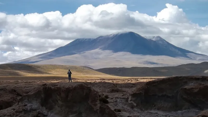
The Cordillera Real Traverse is a masterclass in Andean geography. The range itself stretches for approximately 125 kilometres, and this traverse covers nearly its entire length. The journey begins in the shadow of the Condoriri Massif—a group of peaks shaped like a condor spreading its wings—and concludes in the lush, subtropical valley of Sorata, nestled beneath the massive bulk of Illampu and Ancohuma. Between these two points lies a landscape of staggering scale. The trek is characterised by a "sawtooth" profile: every day involves descending into deep, glaciated valleys only to climb back over high mountain passes. This constant fluctuation in elevation is physically demanding but rewards the trekker with ever-changing perspectives of the range's giants, including Huayna Potosi (6,088 m), Tiquimani (5,519 m), and the massive Illampu (6,368 m).
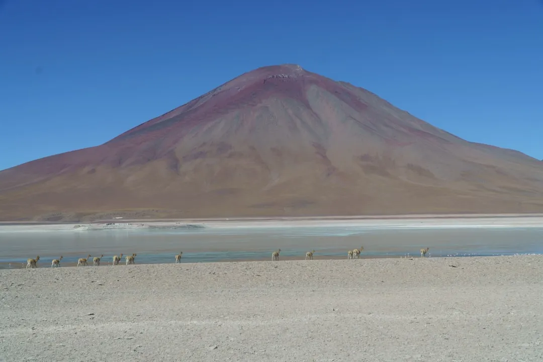
The environment is one of extremes. During the day, the tropical sun at high altitude can be intense, requiring careful protection, while as soon as the sun dips behind the peaks, temperatures plummet well below freezing. The terrain varies from spongy bofedales (high-altitude wetlands) and scree-covered slopes to ancient Inca pathways and narrow ridges. Water is a constant theme, with the trail passing dozens of emerald and turquoise lakes, many of which serve as the primary campsites. These lakes are fed by the rapidly receding glaciers that cling to the western faces of the peaks, providing a sobering look at the impacts of climate change in the Andes.
Logistically, the traverse is a serious undertaking. There are no permanent settlements or resupply points between the trailhead at Tuni and the final descent into Sorata. Trekkers must be entirely self-sufficient, carrying all food, fuel, and shelter, or employ the services of local porters and muleteers (arrieros). The lack of infrastructure is precisely what makes the Cordillera Real so special; it remains one of the few places in the world where a trekker can spend ten days in a world-class mountain range without seeing a single road or permanent building. It is a journey that demands physical fitness, mental fortitude, and a deep respect for the power of the high mountains.
History and Cultural Context
The Cordillera Real has been a site of human activity for thousands of years. Long before the arrival of the Spanish, the Aymara people inhabited these high valleys, developing sophisticated agricultural techniques and a deep spiritual connection to the mountains. To the Aymara, the high peaks are not just rock and ice; they are "Achachilas"—ancestral spirits that protect the people and control the weather. Even today, it is common to see small stone cairns (apachetas) at the top of high passes, where travellers leave offerings of coca leaves or stones to ensure safe passage. The mountains are a living part of the cultural landscape, and the traverse passes through traditional grazing lands where families still move their herds of llamas and alpacas according to the seasons.
The range also holds remnants of the Inca Empire. During the 15th and 16th centuries, the Inca expanded their territory into the Bolivian highlands, constructing a network of roads (the Qhapaq Ñan) to connect their vast empire. Sections of the Cordillera Real Traverse follow these ancient stone-paved paths, particularly on the descents towards the Yungas (the transition zone between the Andes and the Amazon). These roads were engineering marvels, designed to withstand the harsh mountain climate and provide efficient transport for messengers and armies. Walking on stones laid down over five hundred years ago adds a profound historical dimension to the trek.
In more recent history, the Cordillera Real became a focal point for international mountaineering. The range's accessibility from La Paz made it a popular destination for European explorers in the late 19th and early 20th centuries. Sir Martin Conway, a British mountaineer, made several significant first ascents in the range in the 1890s, bringing global attention to the "Bolivian Alps." Today, the traverse is recognised as one of the premier long-distance treks in the world, though it remains far less commercialised than its counterparts in Europe or Nepal. The preservation of its wild character is a testament to the remoteness of the region and the enduring traditions of the local communities.
Want more background? Read extended notes on history and cultural context → Learn more
Seasonal Highlights and Weather Reality
The trekking season in the Cordillera Real is strictly defined by the Andean dry season, which runs from May to September. During these months, the weather is remarkably stable, characterised by clear blue skies and very little precipitation. This "Andean Winter" provides the best conditions for navigation and photography, as the visibility is often limitless. However, the clear skies come at a price: without cloud cover to trap the heat, night-time temperatures at 4,500 metres regularly drop to -10°C or even -15°C. Trekkers must be prepared for bitter cold as soon as the sun sets.
June and July are the driest months and offer the most reliable weather, but they are also the coldest. August can bring increased winds, particularly on the high passes, which can make the "real feel" temperature significantly lower. By September, the transition to the rainy season begins, and while the temperatures are slightly warmer, the risk of afternoon thunderstorms and snow on the passes increases. Snow can occur at any time of year at these altitudes, but during the dry season, it usually evaporates quickly under the intense sun.
The rainy season (October to April) is generally not recommended for the full traverse. Heavy snowfall can make the high passes impassable and extremely dangerous due to avalanche risk and hidden crevasses on the glaciated sections. Furthermore, the valleys often fill with thick cloud and mist, obscuring the very views that make the trek worthwhile. The bofedales (wetlands) also become much more difficult to cross, often turning into impassable bogs. For those seeking the best experience, the window between late May and early August is the gold standard for the Cordillera Real.
Recommended Itinerary

10-Day Cordillera Real Traverse Itinerary
Day 1: Tuni to Laguna Chiarkhota
- Distance: 9 km
- Elevation gain: 300 m
- Time: 3–4 hours
- Transfer from La Paz to the village of Tuni (4,400 m)
- Gentle climb through llama grazing lands towards the Condoriri Massif
- Arrive at Laguna Chiarkhota (4,670 m), a stunning base camp surrounded by jagged peaks
- Key waypoints: Tuni Dam, Mount Condoriri views
- This short day is essential for final acclimatisation before the higher passes
Day 2: Laguna Chiarkhota to Laguna Liviñosa
- Distance: 12 km
- Elevation gain: 600 m
- Time: 6–7 hours
- Cross the Aguja Negra Pass (5,000 m)
- Spectacular views of the "Black Needle" and the back side of Condoriri
- Steep descent into a remote valley before a final climb to Laguna Liviñosa
- Camp at the edge of the lake with views of the Altiplano in the distance
Day 3: Laguna Liviñosa to Botijlaca
- Distance: 15 km
- Elevation loss: 800 m
- Time: 5–6 hours
- A long descent through changing vegetation zones
- Pass through small Aymara hamlets where traditional life continues unchanged
- Arrive at the valley floor near Botijlaca (3,800 m)
- This is the lowest point of the trek and offers a chance to breathe easier in the thicker air
Day 4: Botijlaca to Laguna Juri Khota
- Distance: 14 km
- Elevation gain: 900 m
- Time: 7–8 hours
- A challenging day of sustained climbing back into the high mountains
- Follow a remote river valley up towards the glaciers
- Arrive at Laguna Juri Khota (4,700 m), tucked beneath the massive walls of Tiquimani
- One of the most isolated and beautiful campsites on the entire route
Day 5: Laguna Juri Khota to Laguna Glaciar (via Paso Austria)
- Distance: 10 km
- Elevation gain: 700 m
- Time: 6–7 hours
- Cross Paso Austria (5,150 m) for some of the best panoramic views in the Andes
- Views extend to Lake Titicaca on a clear day
- Descend to the spectacular Laguna Glaciar, where icebergs often float in the water
- High-altitude camping at its finest
Day 6: Laguna Glaciar to Laguna Milluni
- Distance: 13 km
- Elevation gain: 400 m
- Time: 6–7 hours
- Traverse high ridges and cross the Paso Milluni (4,900 m)
- Views of the abandoned Milluni mines and the towering Huayna Potosi
- Camp near the colourful Laguna Milluni, known for its reddish hues due to mineral runoff
Day 7: Laguna Milluni to Laguna Jancko Khota
- Distance: 16 km
- Elevation gain: 500 m
- Time: 7–8 hours
- A long day traversing the central section of the range
- Cross several smaller passes and navigate through vast boulder fields
- Arrive at the "White Lake" (Jancko Khota) at 4,750 m
Day 8: Laguna Jancko Khota to Laguna Leche Khota
- Distance: 12 km
- Elevation gain: 600 m
- Time: 6–7 hours
- Cross the Paso Mullu (5,000 m), a high and often windy saddle
- Descend into the valley of the "Milky Lake" (Leche Khota)
- The water here has a distinct opaque quality from glacial flour
Day 9: Laguna Leche Khota to Laguna San Francisco
- Distance: 14 km
- Elevation gain: 550 m
- Time: 7–8 hours
- The final high pass: Paso Calzada (5,050 m)
- Incredible views of the Illampu and Ancohuma massifs to the north
- Descend to Laguna San Francisco, which often features natural hot springs nearby
Day 10: Laguna San Francisco to Sorata
- Distance: 18 km
- Elevation loss: 2,000 m
- Time: 6–7 hours
- A massive descent from the high alpine zone into the subtropical valley of Sorata
- Watch the landscape transform from rock and ice to lush forests and fruit orchards
- Finish in the charming colonial town of Sorata (2,670 m)
- Celebrate with a cold beer and a warm bed
Important Notes:
- Acclimatisation is non-negotiable; spend at least 3–4 days in La Paz before starting
- Navigation can be difficult in mist; GPS and topographical maps are essential
- Mules can be hired at Tuni to carry heavy gear, which is highly recommended
- Water must be treated due to livestock presence in the lower valleys
- The route is remote; ensure you have a satellite communication device
Planning and Bookings
Book Your Trip
Everything you need to plan your journey
Accommodation
Find places to stay near La Paz
Flights
Search flights to La Paz
Essential Preparation
The Cordillera Real Traverse is a serious high-altitude undertaking that requires meticulous preparation. The most critical factor is acclimatisation. Starting a trek at 4,400 metres and immediately climbing to 5,000 metres without proper adjustment is a recipe for severe altitude sickness (AMS). Most trekkers spend at least three to five days in La Paz (3,600 m) or at Lake Titicaca (3,800 m) before heading to the trailhead. Fitness is also paramount; you will be hiking for 6–8 hours a day with significant elevation changes at altitudes where oxygen levels are roughly 50% of those at sea level.
Logistically, you must decide between an independent trek or an organised tour. Independent trekking is possible for experienced navigators but requires carrying heavy loads (20kg+) or arranging your own mules at the trailhead. Most people opt for a guided service from La Paz, which includes transport, a professional guide, a cook, and arrieros (muleteers) with pack animals. This not only supports the local economy but significantly increases the safety and enjoyment of the trip.
Trail Accommodation
There are no huts, lodges, or formal campsites with facilities on the Cordillera Real Traverse. This is a pure wild camping experience.
Camping Conditions:
- Campsites are typically located near glacial lakes or in sheltered valleys
- No toilets are provided; trekkers must follow strict LNT protocols for waste
- No running water; water is sourced from lakes or streams and must be treated
- Ground can be rocky or damp (bofedales); a high-quality sleeping mat is essential
- Night temperatures are extremely cold (-5°C to -15°C)
What is NOT provided:
- There are no shelters or emergency huts along the route
- No food or fuel is available for purchase once you leave the trailhead
- No electricity or mobile signal for the duration of the trek
Costs:
- Wild camping is generally free, but local communities may charge a small "derecho de paso" (right of way) or camping fee of 10–20 Bolivianos per person
- If using a guide service, all camping equipment and fees are typically included in the package price
Required Gear
- 4-season tent - Must be able to withstand high winds and potential snow loads
- 4-season sleeping bag - Comfort rating of at least -15°C is recommended
- Insulated sleeping mat - High R-value (4+) to protect against the frozen ground
- Sturdy trekking boots - Waterproof, well broken-in, and with excellent ankle support
- High-quality waterproof jacket and trousers - Gore-Tex or similar for wind and snow protection
- Down jacket - Essential for the freezing evenings and mornings at camp
- GPS and topographical maps - Navigation is complex and trails are often faint
- Satellite messenger - (e.g., Garmin inReach) for emergencies in this remote region
What to Bring
- Food for 10–12 days - High-calorie, lightweight meals (dehydrated is best)
- Multi-fuel or gas stove - Note that gas canisters can be less efficient at extreme altitude
- Water purification - UV filters (Steripen) or chlorine dioxide drops are effective
- Sun protection - SPF 50+ sunscreen, lip balm with SPF, and Category 4 sunglasses
- Warm layers - Merino wool base layers, fleece mid-layers, warm hat, and heavy gloves
- First aid kit - Must include Diamox (for altitude), rehydration salts, and blister care
- Coca leaves or candy - A local remedy for altitude that many find helpful
- Power bank - To keep GPS and cameras charged in the cold
Permits
Currently, there is no centralised permit system or national park entry fee for the Cordillera Real Traverse. However, the trek passes through the traditional lands of several different Aymara communities. These communities maintain the trails and manage the grazing lands you will be crossing.
Community Fees:
- It is standard practice for local representatives to collect a small fee from trekkers. This is usually between 10 and 30 Bolivianos (approx. £1–£3) per person, per community
- Always ask for a receipt (recibo) if one is available, though in remote areas, this may not be possible
- Carry plenty of small denomination Boliviano notes, as change is rarely available
- These fees contribute to local infrastructure and the maintenance of the paths you are using
Registration:
- While not a permit, it is highly recommended to register your trekking plans with your embassy in La Paz or with the Socorro Andino Boliviano (Bolivian Alpine Rescue)
- If you are using a trekking agency, they will handle all necessary notifications and community relations
Other Activities in the Area
Bolivia's Altiplano offers numerous world-class adventures that complement the traverse:
- Huayna Potosi Climb: At 6,088 m, this is often cited as the "easiest" 6,000 m peak in the world. Many trekkers add a 2-day climb to the end of their traverse.
- Lake Titicaca: Visit the Isla del Sol, the legendary birthplace of the Inca, for a relaxing post-trek recovery at 3,800 m.
- La Paz City Tour: Explore the Witches' Market, ride the world's highest cable car system (Mi Teleférico), and enjoy the vibrant culinary scene.
- Death Road Mountain Biking: For an adrenaline rush, descend from the high Andes (4,700 m) to the subtropical Yungas (1,200 m) on the world's most famous bike ride.
- Tiwanaku Ruins: Visit the pre-Inca archaeological site that was once the spiritual and political centre of a powerful Andean empire.
Safety and Conditions
Altitude Sickness (AMS): This is the primary safety concern. The entire trek takes place at altitudes where Acute Mountain Sickness is a significant risk. Symptoms include headache, nausea, and dizziness. If symptoms persist or worsen, the only cure is descent. High Altitude Pulmonary Oedema (HAPO) and Cerebral Oedema (HACO) are life-threatening conditions that require immediate evacuation. Never trek alone, and ensure your group has a clear emergency plan.
Weather Extremes: The weather can change with terrifying speed. A clear morning can turn into a whiteout blizzard on a 5,000 m pass within an hour. Hypothermia is a genuine risk if you are not prepared with high-quality waterproof and insulating layers. Always check the forecast in La Paz before departing, but be prepared for the "mountain weather" to ignore the forecast.
Navigation: The "trail" is often a series of braided llama paths rather than a single, well-marked track. In fog or snow, it is incredibly easy to become disoriented. A GPS with pre-loaded topographical maps is mandatory for independent trekkers. Do not rely solely on a mobile phone, as batteries fail quickly in the cold.
Remote Location: There is no mobile phone coverage on 95% of the route. In the event of an injury, help could be days away. A satellite communication device (like an inReach or SPOT) is essential for calling for rescue or communicating with your support team in La Paz.
Water Safety: While the water looks pristine, the presence of llamas and alpacas throughout the range means that water sources are often contaminated with parasites like Giardia. Always treat your water using a reliable method.
Side Trips and Points of Interest
Condoriri Base Camp: Even if you don't do the full traverse, a trip to Laguna Chiarkhota is worth it. The "Cirque of the Condor" is one of the most beautiful mountain amphitheatres in the world, with thirteen peaks reflected in the still waters of the lake.
Paso Austria Summit: From the top of Paso Austria (5,150 m), a further 30-minute scramble leads to the summit of Pico Austria (5,350 m). This is a non-technical hike that offers one of the best views in the entire Cordillera Real, looking directly across at the glaciers of the Condoriri.
Glacial Lakes: Each lake has a different colour depending on its mineral content and the time of day. Laguna Glaciar, located at the foot of Illampu, is particularly famous for its deep blue colour and the icebergs that frequently break off the glacier and float in its waters.
Sorata: The end point of the trek is a destination in itself. This lush valley was once a major centre for the rubber trade and retains a faded colonial grandeur. It is the perfect place to recover, with its warm climate, abundant fruit, and relaxed atmosphere.
Leave No Trace
The Cordillera Real is a fragile high-altitude ecosystem. The slow growth rates at these altitudes mean that any damage can take decades or even centuries to repair. As a trekker, you have a responsibility to protect this wilderness.
LNT Principles for the Andes:
- Waste Management: Pack out all trash, including biodegradable items like orange peels, which do not decompose in the cold, dry air. For human waste, use a trowel to bury it at least 15 cm deep and 60 metres from water sources, or better yet, use a "wag bag" to pack it out.
- Campsite Selection: Use established campsites where possible to avoid crushing fragile alpine vegetation. Avoid camping on bofedales (wetlands).
- Water Protection: Do not use soap directly in lakes or streams. Carry water 60 metres away from the source for washing.
- Respect Wildlife: Do not feed or disturb the Andean Condors, Vizcachas (mountain rodents), or domestic herds.
- Cultural Respect: Always ask permission before taking photos of local people. Respect the "Achachilas" by not disturbing stone cairns or sacred sites.