Cordillera Huayhuash Circuit - The Alpine Crown of the Andes
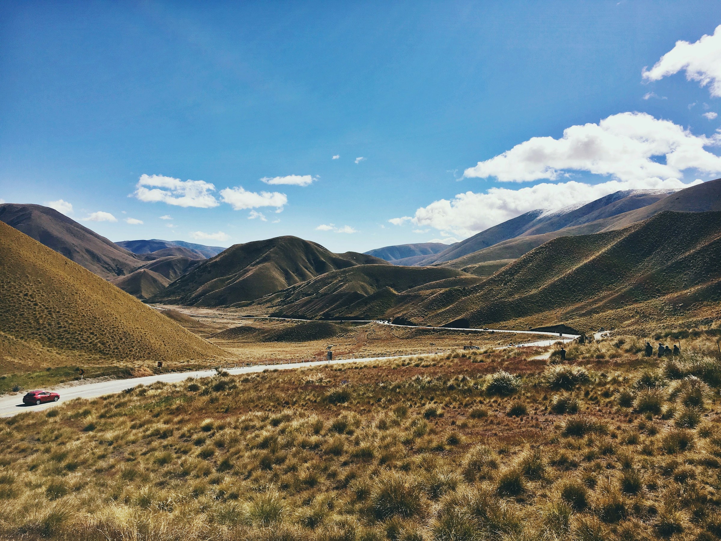
The Cordillera Huayhuash Circuit is widely regarded by the international trekking community as one of the most spectacular high-altitude journeys on Earth. Located in the heart of the Peruvian Andes, this 130-kilometre loop traverses a compact but incredibly jagged mountain range that contains some of the most formidable peaks in South America, including the legendary Yerupajá (6,634 m)—the second-highest mountain in Peru—and the notorious Siula Grande, made famous by Joe Simpson’s survival epic, Touching the Void. Unlike the more crowded trails near Cusco, the Huayhuash offers a raw, uncompromising wilderness experience where the scale of the landscape is matched only by the physical challenge of the route. Every day on this circuit involves crossing high-altitude passes, most of which exceed 4,500 metres, providing trekkers with a constant, revolving panorama of turquoise glacial lakes, sprawling icefields, and vertical granite walls that seem to defy gravity.
- Distance: 130 km loop
- Duration: 8–12 days
- Season: May to September (the Andean "dry season" or "Andean Summer")
- Campsites: Community-managed sites including Cuartelwain, Carhuacocha, and Huayllapa
- Highest point: Punta Cuyoc (5,000 m) or optional Cerro San Antonio (5,020 m)
- Average Elevation: Most of the trek remains above 4,000 metres
- Difficulty: Very Challenging (requires excellent fitness and high-altitude acclimatisation)
- Direction: Typically walked anti-clockwise starting from Llamac or Pocpa
Overview
The Cordillera Huayhuash Circuit is not merely a hike; it is a sustained high-altitude expedition that tests the limits of human endurance and rewards it with unparalleled natural beauty. While the nearby Cordillera Blanca is larger and more accessible, the Huayhuash is more intimate and dramatic. The range is only 30 kilometres long from north to south, yet it contains seven peaks over 6,000 metres and dozens over 5,000 metres. This density of giants means that trekkers are never far from the "the big walls." The circuit winds through deep valleys and over high ridges, offering a new perspective on the icy massifs of Jirishanca, Yerupajá Chico, and Sarapo every few hours. The terrain is a mix of dusty mule trails, steep scree slopes, and lush alpine meadows (puna) where llamas and alpacas graze under the watchful eyes of Andean condors.
The physical demands of the Huayhuash are significant. Over the course of 10 to 12 days, trekkers will accumulate approximately 10,000 metres of elevation gain. This is equivalent to climbing from sea level to the summit of Mount Everest and back down, then doing a significant portion of it again. The thin air is a constant factor; even the valley floors are higher than the highest peaks in the European Alps or the Rocky Mountains. Consequently, the rhythm of the trek is slow and deliberate. Success on the Huayhuash is determined not by speed, but by the body's ability to adapt to the lack of oxygen and the cold, crisp nights where temperatures frequently drop well below freezing.
Culturally, the trek provides a window into the lives of the Quechua-speaking communities that have inhabited these mountains for centuries. The circuit passes through several remote villages and community-managed lands. Unlike many national parks, the Huayhuash is a living landscape where traditional pastoralism continues alongside tourism. The "pagos" or trekking fees paid at each campsite go directly to the local communities, supporting schools, infrastructure, and conservation efforts. This unique management system ensures that the benefits of tourism are shared by those who call these high valleys home, creating a sense of partnership between the visitor and the local population.
History and Cultural Context
The history of the Cordillera Huayhuash is a tapestry of ancient indigenous heritage, colonial influence, and modern mountaineering legend. For the Quechua people, these mountains are more than just geological features; they are Apus—powerful mountain spirits that protect the land and its inhabitants. The traditional routes used by trekkers today often follow the same paths used by ancient herders to move livestock between seasonal pastures. Evidence of pre-Inca and Inca influence can be found throughout the region, though the Huayhuash remained relatively isolated compared to the more central parts of the Inca Empire due to its rugged and vertical topography.
In the 20th century, the Huayhuash became a focal point for world-class mountaineering. The first ascent of Yerupajá in 1950 by Jim Maxwell and Dave Harrah marked the beginning of a golden age of Andean climbing. However, the range gained its most significant international fame through the harrowing story of Joe Simpson and Simon Yates on Siula Grande in 1985. Their struggle for survival, documented in the book and film Touching the Void, transformed the Huayhuash into a place of pilgrimage for those fascinated by the limits of human willpower. Standing at the base of Siula Grande today, looking up at the chaotic icefall and the West Face, one cannot help but feel a profound sense of awe for the drama that unfolded there.
The region also navigated a difficult period in the 1980s and early 1990s during the internal conflict in Peru involving the Shining Path (Sendero Luminoso). For a time, the Huayhuash was considered too dangerous for tourism. However, since the mid-1990s, the region has seen a remarkable transformation. The local communities took charge of their security and the management of the trekking routes, leading to the peaceful and well-organised system in place today. The establishment of the Cordillera Huayhuash Private Conservation Area in 2002 was a landmark moment, formalising the protection of the range's biodiversity and water sources while ensuring the sustainable development of trekking tourism.
Want more background? Read extended notes on history and cultural context → Learn more
Seasonal Highlights and Weather Reality
The trekking season in the Cordillera Huayhuash is dictated by the Andean weather cycle, which consists of a distinct dry season and a wet season. Because of the extreme altitudes, timing your visit is crucial for both safety and the quality of the views.
The Dry Season (May to September): This is the "Andean Summer" and the optimal time to trek. During these months, the weather is characterised by stable high-pressure systems that bring clear, deep-blue skies and brilliant sunshine. Visibility is at its peak, making it the best time for photography and for navigating the high passes. However, "dry" does not mean "warm." While daytime temperatures in the sun can be pleasant (15°C to 20°C), the lack of cloud cover means that heat escapes rapidly as soon as the sun sets. Night-time temperatures at campsites like Laguna Jahuacocha or Cuartelwain regularly drop to -5°C or even -10°C. Frost on tents is a daily occurrence.
The Shoulder Seasons (April and October): These months can be a gamble. April often sees the tail end of the rains, which leaves the mountains incredibly green and the wildflowers in full bloom, but the risk of afternoon storms remains high. October brings the first signs of the returning rains. Trekkers during these months will find fewer people on the trail but must be prepared for more volatile weather and potential snow on the higher passes.
The Wet Season (November to March): Trekking the full circuit during the wet season is generally not recommended for recreational hikers. Heavy rain in the valleys translates to significant snowfall on the passes, making them dangerous or impassable without technical gear. Clouds often shroud the peaks for days at a time, obscuring the very views that make the Huayhuash famous. Furthermore, the trails become extremely muddy and slippery, increasing the risk of injury. For those who do venture out, the landscape is lush and the solitude is absolute, but the physical toll is much higher.
Recommended Itinerary

10-Day Cordillera Huayhuash Circuit Itinerary
Day 1: Huaraz to Llamac and Cuartelwain
- Distance: 7 km (walking)
- Elevation gain: 300 m
- Time: 2–3 hours walking (plus 4–5 hours driving)
- Drive from Huaraz (3,050 m) via Chiquián to the village of Llamac
- Continue driving to the trailhead at Matacancha or Cuartelwain (4,150 m)
- Short afternoon walk to acclimatise and settle into the first camp
- The first night at 4,150 m is a significant jump; hydration and slow movement are essential
- Views of the northern end of the range begin to appear
Day 2: Cuartelwain to Laguna Mitucocha via Cacananpunta Pass
- Distance: 12 km
- Elevation: 550 m gain, 470 m descent
- Time: 5–6 hours
- First major pass: Cacananpunta (4,700 m)
- Cross the continental divide; water now flows toward the Amazon
- Descend into the Mitucocha valley
- Camp at Laguna Mitucocha (4,230 m) beneath the sheer faces of Jirishanca and Rondoy
- Stunning sunset reflections on the lake if the weather is clear
Day 3: Laguna Mitucocha to Laguna Carhuacocha via Carhuac Pass
- Distance: 12 km
- Elevation: 420 m gain, 520 m descent
- Time: 5 hours
- Climb to Carhuac Pass (4,650 m)
- The pass offers the first truly panoramic view of the "Big Three": Yerupajá, Yerupajá Chico, and Jirishanca
- Easy descent to Laguna Carhuacocha (4,130 m)
- Carhuacocha is widely considered the most beautiful campsite on the circuit
- The massive east faces of the peaks rise directly from the opposite shore of the lake
Day 4: Laguna Carhuacocha to Huayhuash Camp via Siula Pass
- Distance: 14 km
- Elevation: 670 m gain, 500 m descent
- Time: 7–8 hours
- The "Alpine Route" option via the three lakes (Gangrajanca, Siula, and Quesillococha)
- Steep climb to Siula Pass (4,800 m) with breathtaking views of the glaciers calving into the lakes below
- This is a physically demanding day but offers the most iconic photography spots
- Descend to the small settlement and campsite of Huayhuash (4,300 m)
- Observe the local community's alpaca herds in the high meadows
Day 5: Huayhuash Camp to Viconga via Portachuelo de Huayhuash
- Distance: 12 km
- Elevation: 450 m gain, 350 m descent
- Time: 5–6 hours
- Ascend to Portachuelo de Huayhuash (4,750 m)
- Views extend south toward the Cordillera Raura
- Descend toward the large Viconga dam and reservoir
- Camp at Viconga (4,400 m) near the natural hot springs (Termas de Atoc)
- The hot springs are a highlight of the trip, allowing for a much-needed soak and "bath"
Day 6: Viconga to Elefante Camp via Punta Cuyoc
- Distance: 11 km
- Elevation: 600 m gain, 550 m descent
- Time: 6–7 hours
- Climb to the highest official pass on the standard circuit: Punta Cuyoc (5,000 m)
- The terrain becomes stark, volcanic, and almost lunar in appearance
- Spectacular views of the southern faces of Puscanturpa and Cuyoc
- Steep, loose scree descent into the Huanacpatay valley
- Camp at Elefante or Cuyoc camp (4,450 m)
Day 7: Elefante Camp to Huayllapa via San Antonio Pass (Optional)
- Distance: 15 km
- Elevation: 570 m gain, 1,100 m descent
- Time: 7–8 hours
- Optional but highly recommended side trip to Cerro San Antonio (5,020 m)
- The view from San Antonio is arguably the best in the Andes, looking directly into the heart of the range and Siula Grande
- Extremely steep descent into the lush, deep valley of the Calinca River
- Arrive at the village of Huayllapa (3,600 m)—the first village in a week
- Opportunity to buy basic supplies (chocolate, soda, beer) and enjoy the "thick" air
Day 8: Huayllapa to Gashpapampa via Tapush Pass
- Distance: 13 km
- Elevation: 1,200 m gain, 300 m descent
- Time: 6–7 hours
- A long, steady climb out of the valley back into the high alpine zone
- Cross Tapush Pass (4,800 m)
- Views of the isolated peak of Diablo Mudo (Silent Devil)
- Camp at Gashpapampa (4,500 m)
- This is often the coldest campsite due to its exposed position
Day 9: Gashpapampa to Laguna Jahuacocha via Yaucha Pass
- Distance: 12 km
- Elevation: 350 m gain, 800 m descent
- Time: 5–6 hours
- Climb to Yaucha Pass (4,850 m)
- On a clear day, you can see the peaks of the Cordillera Blanca in the far distance
- The descent offers incredible views of the western faces of the Huayhuash giants
- Camp at Laguna Jahuacocha (4,050 m), the final spectacular lake of the circuit
- Final night celebration with the trekking crew
Day 10: Laguna Jahuacocha to Llamac and Huaraz
- Distance: 14 km
- Elevation: 250 m gain, 800 m descent
- Time: 5 hours walking (plus 4 hours driving)
- Final short climb to Pampa Llamac (4,300 m) for a last look at the range
- Long, dusty descent back to the village of Llamac (3,300 m)
- Meet transport for the drive back to Huaraz
- Enjoy a hot shower and a celebratory meal in Huaraz
Important Notes:
- Acclimatisation: Spend at least 3–4 days in Huaraz (3,050 m) doing day hikes before starting
- Hydration: Drink 4–5 litres of water daily to combat altitude sickness
- Community Fees: Carry enough Soles (local currency) to pay the fees at each campsite
- Mules/Arrieros: Most trekkers hire a local muleteer (arriero) and donkeys to carry heavy gear
- Water Treatment: All water from streams must be filtered or treated due to livestock
Planning and Bookings
Book Your Trip
Everything you need to plan your journey
Accommodation
Find places to stay near Huaraz
Flights
Search flights to Huaraz
Essential Preparation
The most critical element of preparation for the Cordillera Huayhuash is acclimatisation. Attempting this trek without prior time at altitude is dangerous and likely to result in failure. Most trekkers base themselves in Huaraz for several days, completing "warm-up" hikes like Laguna 69 (4,600 m) or the Pastoruri Glacier. Physical fitness should be at a high level; you should be comfortable walking 6–8 hours a day for multiple days with significant elevation changes.
Logistically, you must decide between an organised tour or an independent trek. Organised tours provide a guide, a cook, and arrieros (muleteers) with donkeys. This allows you to walk with only a daypack, which is a significant advantage at 5,000 metres. If trekking independently, you must be self-sufficient with navigation, food, and gear, though you can still hire arrieros in Llamac or Pocpa. Coordination of transport from Huaraz to the trailhead is usually done via private taxi or the local "colectivo" bus system.
Trail Accommodation
There are no huts or lodges on the Cordillera Huayhuash Circuit. This is a pure camping trek. You must bring a high-quality, four-season tent capable of withstanding strong winds and sub-zero temperatures.
Campsite Facilities:
- Designated flat areas for pitching tents
- Basic pit toilets (quality varies significantly between communities)
- Access to a water source (usually a nearby stream or lake)
- Some sites (like Huayllapa or Carhuacocha) may have very basic "tiendas" selling snacks
- The Viconga campsite features natural thermal pools for bathing
What Campsites Don't Provide:
- Shelter or indoor cooking areas
- Electricity or phone charging
- Trash disposal (you must pack out all rubbish)
- Bedding or mattresses
- Prepared food (unless you are on a guided tour with a cook)
Booking and Costs:
- No advance booking is required for the trail or campsites
- You pay "community fees" (pagos) in cash as you enter each community's land
- Total fees for the full circuit typically amount to 250–300 Peruvian Soles (approx. £55–£70)
- Keep your receipts, as they are occasionally checked by community members on the trail
Required Gear
- Four-season tent - must be wind-resistant and rated for freezing temperatures
- Sleeping bag - rated to at least -10°C (comfort rating, not limit)
- Sleeping mat - high R-value (insulated) to protect against the frozen ground
- Trekking boots - sturdy, waterproof, and well-broken-in with good ankle support
- Backpack - 60-75L if independent; 25-35L daypack if using mules
- Water filtration - a high-quality filter (like Sawyer or Katadyn) or UV purifier
- Navigation - GPS with offline maps, plus a physical topographic map and compass
- Trekking poles - essential for the steep, loose descents and saving your knees
- Head torch - with extra batteries (nights are long and dark)
What to Bring
- Layered clothing - merino wool base layers, fleece mid-layer, down jacket, and waterproof shell
- Sun protection - high SPF sunscreen, lip balm with SPF, and Category 4 sunglasses (glacier glasses)
- First aid kit - including Diamox (for altitude), Ibuprofen, blister care, and rehydration salts
- Food - lightweight, high-calorie meals (dehydrated) and plenty of snacks (nuts, chocolate, energy bars)
- Fuel - gas canisters can be purchased in Huaraz (cannot be flown in)
- Personal hygiene - biodegradable soap, wet wipes, hand sanitiser, and a small trowel for LNT
- Cash - plenty of Peruvian Soles in small denominations for community fees and village supplies
- Emergency communication - a satellite messenger (like Garmin inReach) is highly recommended as there is no mobile signal
Permits
Unlike the Inca Trail, the Cordillera Huayhuash does not require a single government-issued permit. Instead, the trail passes through the lands of several different rural communities (Comunidades Campesinas). Each community manages its own section of the trail and its own campsites. This decentralised system means you pay as you go.
The Payment Process:
- As you enter a new community's territory or arrive at a campsite, a representative (often wearing a vest or carrying an ID) will approach you to collect the fee
- Fees range from 20 to 50 Soles per person depending on the community
- In exchange for the fee, you are issued a paper ticket/receipt
- Keep these receipts in a waterproof bag; you may be asked to show them further down the trail to prove you have paid
Community Fees (Approximate):
- Llamac: 30 Soles
- Pocpa: 20 Soles
- Cuartelwain: 40 Soles
- Carhuacocha: 50 Soles
- Huayhuash: 30 Soles
- Viconga: 30 Soles
- Huayllapa: 40 Soles
- Jahuacocha: 40 Soles
Logistics and Strategy:
- There is no way to pay these fees in advance or via credit card. You must have cash in Peruvian Soles
- Try to carry small bills (10s and 20s), as the community representatives often do not have change for 100-Soles notes
- The total cost of fees is a small price to pay for the maintenance of the trails and the security provided by the communities
- If you are on an organised tour, these fees are almost always included in your trip price, but verify this with your operator beforehand
Other Activities in the Area
Huaraz is the "Outdoor Capital of Peru," and there is much to do before or after your Huayhuash trek:
- Santa Cruz Trek: A shorter, 4-day classic trek in the Cordillera Blanca, perfect for acclimatisation or as a follow-up to the Huayhuash.
- Laguna 69: A challenging day hike to a brilliant turquoise lake at 4,600 m. It is the most popular acclimatisation hike in the region.
- Rock Climbing in Hatun Machay: A "stone forest" at 4,200 m offering hundreds of sport climbing routes in a surreal volcanic landscape.
- Pastoruri Glacier: A high-altitude visit to one of the few glaciers accessible by road, offering a sobering look at the effects of climate change.
- Chavín de Huántar: An archaeological site and UNESCO World Heritage site pre-dating the Incas by over 2,000 years, located a few hours from Huaraz.
- Ice Climbing and Mountaineering: For those with technical skills, peaks like Pisco (5,752 m) or Ishinca (5,530 m) are popular non-technical climbs.
Safety and Conditions
Altitude Sickness (AMS): This is the primary safety concern on the Huayhuash. Acute Mountain Sickness can affect anyone, regardless of fitness. Symptoms include headache, nausea, dizziness, and fatigue. The only cure for severe AMS is descent. Trekkers should be aware of the more serious conditions: HAPE (High Altitude Pulmonary Edema) and HACE (High Altitude Cerebral Edema), which are life-threatening. Carry Diamox, stay hydrated, and never ignore persistent symptoms.
Weather and Exposure: The Andean weather can change in minutes. A sunny morning can turn into a blizzard on a 5,000-metre pass by midday. Hypothermia is a genuine risk if you get wet and the wind picks up. Always keep your waterproofs and a warm layer at the top of your pack. The sun at this altitude is incredibly strong; UV protection for skin and eyes is mandatory to prevent severe burns and snow blindness.
Water Safety: While the water in the Huayhuash looks pristine, the entire range is used for livestock grazing. Cows, sheep, and alpacas are present even at high altitudes. Consequently, all water sources are contaminated with bacteria and parasites like Giardia. Never drink untreated water. Use a high-quality filter or chemical treatment (chlorine dioxide).
Remote Location: There is no mobile phone coverage on 95% of the circuit. In the event of an injury, help can be days away. If you are trekking independently, a satellite communication device (Garmin inReach or Zoleo) is essential. If using an organised tour, ensure your guide carries a satellite phone and oxygen cylinders.
Security: While the region is now very safe, it is still wise to trek in a group and stay at designated campsites. The community fee system has largely eliminated the security issues of the past, as the local people now have a vested interest in the safety and well-being of trekkers.
Side Trips and Points of Interest
Cerro San Antonio Viewpoint: Often considered the "secret" highlight of the trek. Instead of taking the standard valley route from Elefante Camp to Huayllapa, many trekkers opt to climb the San Antonio Pass. From the ridge, you look straight across the valley at the massive West Face of Siula Grande and Yerupajá. The scale is so immense it is difficult for the brain to process. The descent on the other side is a 1,000-metre "scree run" that is both terrifying and exhilarating.
Siula Grande Base Camp: For fans of Touching the Void, a short detour from the main trail near Sarapococha allows you to visit the site of Joe Simpson's base camp. Standing in the shadow of the mountain and looking up at the chaotic glacier where he crawled for three days is a powerful and humbling experience.
Laguna Jahuacocha: While this is a standard campsite on the final night, it is worth spending an extra day here if your schedule allows. The lake offers excellent trout fishing (with local permission) and several day-hike options to the base of the glaciers of Yerupajá and Jirishanca. The "Rasac" side trip from here provides a close-up view of the hanging glaciers on the western side of the range.
Termas de Atoc (Viconga Hot Springs): These natural volcanic springs have been developed into several concrete pools. After five days of cold Andean air and no showers, soaking in 38°C water while looking up at the stars and the surrounding peaks is a luxury that feels far more valuable than any five-star hotel.
Leave No Trace
The Cordillera Huayhuash is a fragile high-alpine ecosystem. The combination of extreme cold, thin soil, and high UV radiation means that plants grow very slowly and the environment takes a long time to recover from human impact. With the increasing popularity of the trek, adhering to Leave No Trace principles is essential to prevent the "loving to death" of this spectacular range.
Your responsibility as a walker:
- Pack it in, pack it out: There is no rubbish collection in the mountains. Every piece of plastic, every cigarette butt, and every bit of food packaging must be carried back to Huaraz. This includes organic waste like orange peels, which do not decompose at 4,500 metres.
- Proper Waste Disposal: Use the community-provided pit toilets whenever possible. If you must go between campsites, use a "cat hole" at least 20 cm deep and 60 metres from any water source. Pack out your used toilet paper in a sealed bag.
- Protect the Water: Do not use soap (even biodegradable soap) directly in the lakes or streams. Carry water 60 metres away from the source for washing. The lakes are the primary water source for the communities downstream.
- Respect the Wildlife: Do not feed or approach the Andean foxes, condors, or vicuñas. Keep a respectful distance from the local communities' livestock.
- Stay on the Trail: Braided trails cause erosion and destroy the delicate ichu grass and alpine cushion plants. Stick to the main path even if it is muddy.
- No Campfires: Wood is extremely scarce at these altitudes and is needed by the local people. Use a camping stove for all cooking.
By following these guidelines, you ensure that the Huayhuash remains as pristine for the next generation of trekkers as it was for the first explorers. Respect the land, the people, and the Apus.