Cordillera Blanca Trek - The Throne of the Andes
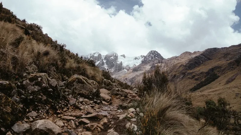
The Cordillera Blanca Trek, specifically the world-renowned Santa Cruz route, is Peru's most spectacular high-altitude odyssey. Traversing the heart of the Huascarán National Park—a UNESCO World Heritage site—this 60-kilometre journey takes walkers through a landscape of superlative mountain scenery. The Cordillera Blanca is the highest tropical mountain range on Earth, home to over 700 glaciers and 30 peaks that soar above 6,000 metres, including the majestic Huascarán (6,768 m), Peru's highest point. This trek is not merely a walk; it is a profound immersion into a vertical world where turquoise glacial lakes reflect jagged granite spires and ancient Polylepis forests cling to the edges of deep, U-shaped valleys. Starting from the bustling mountaineering hub of Huaraz, the trek crosses the formidable Punta Union pass at 4,750 metres, offering a perspective of the Andes that is both humbling and exhilarating. It is a test of endurance, a lesson in acclimatisation, and a journey through one of the most geologically dramatic regions on the planet.
- Distance: 60.0 km point-to-point
- Duration: 4–5 days
- Season: May to September (Andean Summer / Dry Season)
- Accommodation: Wilderness camping (no huts or lodges on trail)
- Highest point: Punta Union Pass (4,750 m)
- Elevation Gain: 3,600 m total ascent
- Difficulty: Challenging (due to sustained high altitude)
- Closest City: Huaraz, Ancash Region, Peru
Overview
The Cordillera Blanca Trek is often cited as one of the top ten hikes in the world, and for good reason. Unlike the more famous Inca Trail to Machu Picchu, which focuses heavily on archaeological ruins, the Cordillera Blanca is a celebration of raw, unadulterated mountain wilderness. The range is a massive batholith of granite that was uplifted millions of years ago and subsequently carved by massive glaciers, creating the deep "quebradas" (valleys) that walkers traverse today. The scale of the landscape is difficult to grasp until you are standing beneath the near-vertical face of Alpamayo, once voted the "Most Beautiful Mountain in the World" by an international photography exhibition.
The trek typically follows the Santa Cruz Valley, beginning in the arid, cactus-strewn lower elevations near Cashapampa and ascending into the high alpine "puna" grasslands. The transition of ecosystems is startling: within two days, you move from warm, dusty trails where donkeys kick up earth, to frozen moraines where the air is thin and the silence is broken only by the distant thunder of calving glaciers. The physical challenge is significant; while the trails are generally well-defined, the sustained elevation above 4,000 metres places a heavy demand on the cardiovascular system. Success on this trek is determined less by leg strength and more by a patient, disciplined approach to acclimatisation.
What sets this trek apart is the sheer density of high peaks. In most mountain ranges, a 6,000-metre peak is a distant landmark; in the Cordillera Blanca, they are your constant companions. Peaks like Taulliraju, Rinrihirca, and Artesonraju (the mountain famously depicted in the Paramount Pictures logo) loom over the campsites, their ice-fields glowing ghostly white under the Andean stars. The weather in the dry season is remarkably stable, with "Andean Blue" skies during the day and crisp, sub-zero temperatures at night, providing the perfect conditions for high-altitude photography and exploration.
History and Cultural Context
The history of the Cordillera Blanca is a tapestry of ancient indigenous civilisations, colonial exploration, and modern mountaineering triumph and tragedy. Long before the first European climbers arrived, the region was the domain of the Chavín culture (900–200 BC), one of the oldest and most significant pre-Inca civilisations in Peru. They viewed the high peaks as "Apus"—powerful mountain spirits that controlled the weather and the flow of water to the valleys below. To this day, the local Quechua-speaking populations maintain a deep spiritual connection to the mountains, often performing small rituals or "pagos a la tierra" (offerings to the earth) before crossing high passes.
During the Inca expansion, the region was integrated into the Tahuantinsuyo Empire, and sections of the Qhapaq Ñan (the Great Inca Road) can still be found throughout the Ancash region. The Spanish conquest brought a shift in focus toward mining, as the granite and metamorphic rocks of the range held rich deposits of silver and other minerals. However, the high peaks remained largely untouched until the "Golden Age" of Andean mountaineering in the early 20th century. Explorers like Annie Smith Peck and later German and Austrian expeditions in the 1930s began the systematic mapping and climbing of the range's giants.
The region is also marked by the devastating 1970 Ancash earthquake. A massive slab of ice and rock broke off the north peak of Huascarán, creating a debris flow that travelled at speeds of over 280 kilometres per hour, completely burying the city of Yungay and killing over 20,000 people. This event remains the deadliest natural disaster in the history of Peru and led to the establishment of the Huascarán National Park in 1975 to protect the environment and manage the risks associated with glacial retreat. Today, walking the Cordillera Blanca is as much about witnessing this geological volatility as it is about enjoying the scenery. The park was designated a UNESCO World Heritage site in 1985, recognising its unique biodiversity and the critical role its glaciers play in providing water to the arid Peruvian coast.
Want more background? Read extended notes on history and cultural context → Learn more
Seasonal Highlights and Weather Reality
The Cordillera Blanca experiences two distinct seasons: the dry season (Andean Summer) and the wet season (Andean Winter). Because of its proximity to the equator, temperatures do not fluctuate wildly between months, but precipitation patterns change dramatically.
Dry Season (May to September): This is the prime window for trekking. During these months, the "Verano Andino" brings consistent high-pressure systems, resulting in clear, sunny days and deep blue skies. Rainfall is rare, though afternoon clouds can occasionally gather. The visibility is at its peak, making it the best time for photography. However, the lack of cloud cover means that heat escapes rapidly at night; temperatures at campsites above 4,000 metres frequently drop to -5°C or even -10°C. This is the busiest time on the trail, though it never feels crowded compared to European or North American routes.
Shoulder Seasons (April and October): These months can be a gamble. April often sees the tail end of the rains, with the landscape looking incredibly lush and green, and wildflowers in full bloom. October marks the transition back to rain, with more frequent afternoon storms. For experienced trekkers, these months offer more solitude and slightly warmer night-time temperatures, but you must be prepared for wet gear and obscured views.
Wet Season (November to March): Trekking during this period is generally discouraged. Heavy rain, thick fog, and snow at higher elevations make the trails muddy and dangerous. The risk of landslides and rockfalls increases, and the spectacular views that define the Cordillera Blanca are often hidden behind a wall of grey cloud. Many local trekking agencies cease operations during these months as the high passes can become impassable without technical winter equipment.
Recommended Itinerary
4-Day Santa Cruz Trek Itinerary
Day 1: Cashapampa to Llamacorral
- Distance: 11 km
- Elevation gain: 900 m
- Time: 4–5 hours
- Transfer from Huaraz (3,050 m) to the trailhead at Cashapampa (2,900 m) via Caraz
- The trail begins with a steady, sustained climb through the narrow Santa Cruz canyon
- Pass through arid vegetation, including giant cacti and bromeliads
- The river thunders below as the canyon walls rise steeply on either side
- Arrive at Llamacorral campsite (3,750 m), a wide grassy meadow
- First views of the high peaks, including Aguja de Santa Cruz
- Evening temperatures begin to drop significantly as the sun sets behind the canyon walls
Day 2: Llamacorral to Taullipampa
- Distance: 14 km
- Elevation gain: 500 m
- Time: 5–6 hours
- A relatively gentle day in terms of gradient, but the altitude begins to be felt
- Walk past the turquoise waters of Laguna Ichiccocha and Laguna Jatuncocha
- The valley opens up, revealing the spectacular "Paramount" peak, Artesonraju
- Optional side trip to the Alpamayo Base Camp and Arhuaycocha Lake (adds 2–3 hours)
- The Arhuaycocha detour offers the best views of the fluted ice-face of Alpamayo
- Arrive at Taullipampa campsite (4,250 m), situated at the base of the massive Taulliraju peak
- This is one of the most scenic campsites in the world, surrounded by 5,000 m and 6,000 m summits
Day 3: Taullipampa to Paria via Punta Union Pass
- Distance: 14 km
- Elevation: 500 m gain, 1,000 m descent
- Time: 7–8 hours
- The most challenging and rewarding day of the trek
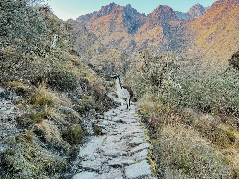
- A steep, switchbacking ascent on an ancient stone-paved trail toward the pass
- Reach Punta Union (4,750 m), the highest point of the journey
- The pass offers a breathtaking 360-degree panorama of the Santa Cruz and Huaripampa valleys
- Views of Taulliraju, Rinrihirca, Artesonraju, and the distant Huascarán massif
- Long, steep descent into the Huaripampa Valley, passing small alpine tarns
- The vegetation changes back to lush Polylepis forest and high-altitude shrubs
- Arrive at Paria campsite (3,700 m) in a sheltered, wooded area
Day 4: Paria to Vaqueria and return to Huaraz
- Distance: 11 km
- Elevation: 200 m gain, 400 m descent
- Time: 4–5 hours
- Continue descending through the Huaripampa Valley, passing through traditional Quechua villages
- Observe local farmers tending to potato crops and livestock
- A final short but steep climb leads out of the valley to the road-head at Vaqueria (3,700 m)
- Meet your pre-arranged transport for the spectacular drive back to Huaraz
- The drive crosses the Portachuelo de Llanganuco pass (4,767 m), offering iconic views of Huascarán and Huandoy
- Pass the famous Llanganuco Lakes (Chinancocha and Orconcocha) before descending to Yungay
- Arrive back in Huaraz by late afternoon for a well-deserved meal
Important Notes:
- Acclimatisation is mandatory; spend at least 2–3 days in Huaraz doing day hikes before starting
- The trek can be done in reverse (Vaqueria to Cashapampa), which involves less total ascent but a higher starting altitude
- Muleteers (arrieros) and donkeys are highly recommended to carry heavy gear and support the local economy
- Water must be treated; the presence of livestock in the valleys means stream water is not safe to drink raw
- Night temperatures are consistently below freezing; a high-quality sleeping bag is essential
Planning and Bookings
Book Your Trip
Everything you need to plan your journey
Accommodation
Find places to stay near Huaraz
Flights
Search flights to Huaraz
Essential Preparation
The single most important factor in planning a Cordillera Blanca trek is acclimatisation. Huaraz sits at 3,050 metres, which is already high enough to cause symptoms of altitude sickness in many people. Attempting to start the trek immediately upon arrival from Lima (sea level) is dangerous and likely to result in failure. A standard preparation protocol involves staying in Huaraz for three nights, with two "acclimatisation hikes" to higher elevations. Popular choices include Laguna Wilcacocha (3,700 m) and the more strenuous Laguna Churup (4,450 m).
Logistically, you must decide between an organised tour or an independent trek. Huaraz is teeming with trekking agencies that provide guides, cooks, muleteers, and all camping equipment. This is the most common way to experience the trail and ensures you can focus on the scenery rather than logistics. If trekking independently, you must be self-sufficient with navigation, high-altitude cooking, and waste management. You will also need to arrange your own transport to Cashapampa and pickup from Vaqueria, which can be done via "colectivos" (shared vans) or private taxis.
Trail Accommodation
There are no huts, lodges, or permanent shelters on the Santa Cruz Trek. This is a pure wilderness camping experience. You must carry or hire all necessary equipment for overnight stays.
Campsite Facilities:
- Designated flat areas for tents (often in meadows or near rivers)
- Basic pit toilets are available at some major campsites (Llamacorral, Taullipampa), but they are rudimentary
- No running water (water must be collected from streams and treated)
- No electricity, WiFi, or mobile signal
- No trash disposal (all waste must be carried out)
What is NOT Provided:
- Tents, sleeping mats, or sleeping bags
- Cooking fuel or stoves
- Food or snacks (there are no shops on the trail)
- Shelter from rain or wind (other than your own tent)
Costs and Availability:
- There is no fee to use the campsites themselves, as the cost is covered by your Huascarán National Park permit
- Campsites do not require booking; they operate on a first-come, first-served basis
- During peak season (July), the best spots at Taullipampa can fill up by mid-afternoon
Required Gear
- 4-Season Tent - Must be able to withstand high winds and potential light snow
- Sleeping Bag - Rated to at least -10°C (comfort rating, not extreme rating)
- Insulated Sleeping Mat - Crucial for blocking the cold from the frozen ground
- Trekking Boots - Sturdy, waterproof, and well-broken-in with good ankle support
- High-Altitude Clothing - Layering system including merino base layers, a heavy down jacket, and a waterproof/breathable shell
- Trekking Poles - Essential for the steep 1,000 m descent from Punta Union to protect knees
- Head Torch - With extra batteries (cold drains battery life quickly)
- Navigation - Topographic map and GPS/Offline map app (the trail is mostly clear but fog can obscure landmarks)
What to Bring
- Water Treatment - A high-quality filter (like a Sawyer Squeeze) or chlorine dioxide drops. UV purifiers are less effective in silty glacial water
- High-Calorie Food - Focus on complex carbohydrates and fats. Appetite often decreases at altitude, so bring foods you genuinely enjoy
- Coca Leaves or Tea - A traditional Andean remedy for altitude; helps with mild headaches and fatigue
- Sun Protection - SPF 50+ sunscreen, lip balm with SPF, and Category 4 sunglasses (the UV radiation at 4,700 m is extreme)
- Personal First Aid Kit - Including Diamox (if prescribed), Ibuprofen, blister kits, and rehydration salts
- Biodegradable Toiletries - Including wet wipes (for "mountain showers") and hand sanitiser
- Power Bank - To keep cameras and phones charged in the cold
- Cash - Small denominations of Peruvian Soles for the muleteers and small purchases in villages
Permits
All trekkers entering the Cordillera Blanca must possess a valid permit for the Huascarán National Park (Parque Nacional Huascarán). These permits are managed by SERNANP (Servicio Nacional de Áreas Naturales Protegidas por el Estado).
Permit Types and Costs:
- Multi-day Permit (4 to 30 days): S/ 150 (approximately US$40) per person. This is the standard permit for the Santa Cruz Trek.
- Short-stay Permit (1 to 3 days): S/ 60 (approximately US$16) per person.
- Day Pass: S/ 30 (approximately US$8) per person.
How to Obtain Permits:
- Permits can be purchased at the SERNANP office in Huaraz (located near the Plaza de Armas) before you depart.
- They can also be purchased at the park entrance control points (e.g., at the start of the trail in Cashapampa or at the Llanganuco gate).
- You must carry your permit with you at all times; park rangers frequently check them at campsites and high passes.
- Payment is generally required in cash (Peruvian Soles). Credit cards are rarely accepted at the park gates.
Regulations:
- The permit is non-transferable and must be signed by the holder.
- Trekkers are required to register their names, nationalities, and planned routes at the entrance stations. This is a critical safety measure in case of emergencies.
- If you are trekking with an organised agency, the permit cost is often included in your package, but you should verify this beforehand.
Other Activities in the Area
Huaraz is the "Adventure Capital of Peru," and there are numerous ways to spend your time before or after the trek:
- Laguna 69: Perhaps the most famous day hike in Peru. A challenging climb to a brilliant neon-blue lake at 4,600 m, situated directly under the ice-cliffs of Chacraraju.
- Pastoruri Glacier: One of the few glaciers in the tropical Andes accessible by road. It is a sobering place to witness the effects of climate change, but the surrounding "Puya Raimondii" (giant bromeliads) are spectacular.
- Chavín de Huántar: A UNESCO-listed archaeological site located a few hours from Huaraz. This 3,000-year-old temple complex features intricate stone carvings and a fascinating network of underground tunnels.
- Rock Climbing at Hatun Machay: A "stone forest" at 4,200 m offering hundreds of sport climbing routes on unique volcanic rock.
- Monterrey Hot Springs: Located just outside Huaraz, these thermal baths are the perfect way to soothe sore muscles after finishing the trek.
- Ice Climbing Courses: For those looking to transition from trekking to mountaineering, many agencies offer 2–3 day introductory courses on the lower glaciers of peaks like Vallunaraju.
Safety and Conditions
Altitude Sickness (AMS): This is the primary safety concern. Acute Mountain Sickness can affect anyone, regardless of fitness level. Symptoms include headache, nausea, dizziness, and loss of appetite. The only cure for severe AMS is immediate descent. More serious conditions like HAPE (High Altitude Pulmonary Edema) and HACE (High Altitude Cerebral Edema) are life-threatening emergencies. Always follow the "climb high, sleep low" rule and stay hydrated.
Water Safety: The valleys of the Cordillera Blanca are used for grazing cattle, sheep, and donkeys. Consequently, almost all surface water is contaminated with parasites like Giardia or bacteria like E. coli. Never drink untreated water. Use a reliable filtration system or chemical treatment for every litre consumed.
Weather Volatility: While the dry season is generally stable, mountain weather can change in minutes. Whiteouts at Punta Union are possible, and sudden snowstorms can occur even in July. Always carry full waterproof gear and know how to use your navigation tools in low visibility.
Sun Exposure: At 4,500 metres, the atmosphere is much thinner, providing less protection from UV rays. Severe sunburn and snow blindness (if crossing snowfields) can happen quickly. Wear a wide-brimmed hat and high-quality sunglasses at all times.
Emergency Communication: There is no mobile phone coverage on the vast majority of the trail. If trekking independently, carrying a satellite messenger (like a Garmin inReach) is highly recommended. In the event of an accident, help can be many hours or even days away.
Side Trips and Points of Interest
Arhuaycocha Lake and Alpamayo Base Camp: This is the most popular side trip on the Santa Cruz Trek. From the valley floor on Day 2, a trail branches off toward the Alpamayo glacier. After a steep climb, you reach the turquoise Arhuaycocha Lake, which sits directly beneath the towering ice-walls of Alpamayo and Quitaraju. Even if you don't go all the way to the lake, the viewpoint (Mirador) offers the iconic "pyramid" view of Alpamayo that has made it world-famous.
Taulliraju Viewpoint: Near the Taullipampa campsite, a short scramble up the moraine walls provides a closer look at the "Cathedral of the Andes"—Taulliraju. The mountain's sheer granite face and hanging glaciers are a masterclass in alpine architecture.
Quechua Villages: On the final day, the trail passes through the Huaripampa Valley. This is a living cultural landscape. Take the time to observe the traditional "adobe" houses and the ingenious irrigation systems that have sustained Andean agriculture for centuries. Interacting respectfully with the local community provides a deeper understanding of the region beyond the mountain scenery.
Portachuelo de Llanganuco: While technically part of the drive back to Huaraz, this pass is a major point of interest. Most drivers will stop at the top (4,767 m) to allow for photographs. From here, you can see four 6,000-metre peaks simultaneously: Huascarán North and South, Huandoy, Pisco, and Chacraraju. It is arguably the most spectacular roadside view in the world.
Leave No Trace
The Huascarán National Park is a fragile ecosystem under significant pressure from climate change and tourism. As a visitor, you have a moral and legal obligation to minimise your impact. The "Puna" grasslands and Polylepis forests are slow-growing and easily damaged.
Core Principles for the Cordillera Blanca:
- Pack it in, pack it out: There are no trash cans on the trail. Every piece of plastic, every orange peel, and every cigarette butt must be carried back to Huaraz.
- Dispose of waste properly: Use the pit toilets where provided. If they are not available, dig a "cathole" at least 15–20 cm deep and at least 60 metres away from any water source. Pack out your used toilet paper in a sealed bag.
- Respect the water: Do not use soap (even biodegradable soap) directly in streams or lakes. Carry water 60 metres away from the source for washing.
- No campfires: Wood is extremely scarce at high altitudes and is a critical habitat for local birds. Use a gas or multi-fuel stove for all cooking.
- Stay on the trail: Avoid creating "social trails" or shortcuts, especially on switchbacks, as this leads to severe soil erosion during the rainy season.
- Respect wildlife and livestock: Observe Andean condors and viscachas from a distance. Do not feed any animals, as it disrupts their natural diet and behaviour.