Continental Divide Trail (CDT) - The King of Thru-Hikes
The Continental Divide Trail (CDT) represents the pinnacle of long-distance trekking in North America, stretching approximately 4,989 kilometres from the Chihuahuan Desert on the Mexican border to the rugged peaks of the Canadian boundary. As the most remote, technically demanding, and primitive of the "Triple Crown" trails, the CDT follows the spine of the Rocky Mountains, traversing five US states: New Mexico, Colorado, Wyoming, Idaho, and Montana. This is not merely a walk; it is a high-altitude navigational challenge that demands self-reliance, physical fortitude, and an intimate understanding of mountain weather systems. Unlike its more manicured siblings, the Appalachian and Pacific Crest Trails, the CDT is often characterised by "choose your own adventure" route finding, where official tread gives way to cross-country navigation and alternate paths through some of the most pristine wilderness remaining in the lower 48 states.
- Distance: 4,989 km (approximate, varies by route choice)
- Duration: 4–6 months
- Elevation Gain: 141,736 m
- Difficulty: Very Challenging
- Highest Point: Grays Peak, Colorado (4,352 m) or Lake City alternates
- Lowest Point: Waterton Lake, Montana (1,280 m) or Columbus, New Mexico (1,182 m)
- States Traversed: New Mexico, Colorado, Wyoming, Idaho, Montana
- Ecosystems: Chihuahuan Desert, Alpine Tundra, Subalpine Forest, High Plains, Glacial Valleys
Overview
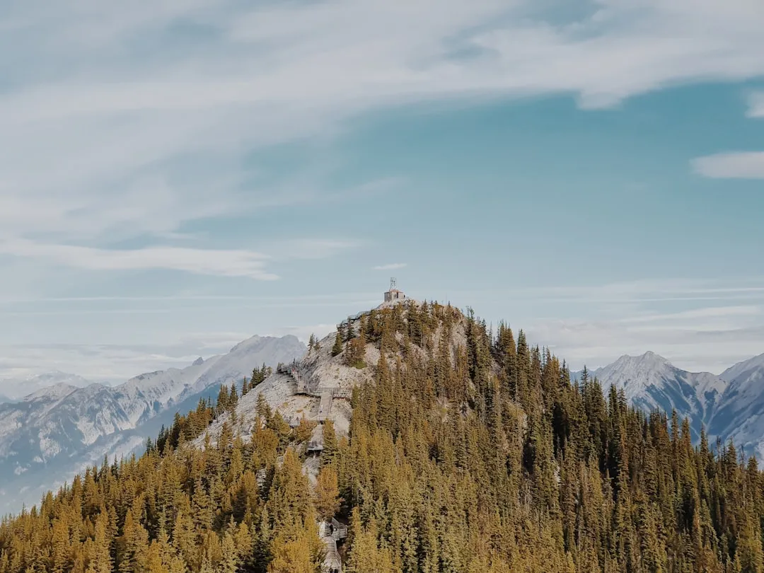
The Continental Divide Trail is widely regarded as the most difficult of the three major American thru-hikes. While the Appalachian Trail is known for its relentless verticality and the Pacific Crest Trail for its sweeping vistas and well-graded paths, the CDT is defined by its raw, unfinished nature. Only about 70% of the trail is currently "on-tread," meaning hikers must frequently rely on maps, GPS, and compass skills to navigate through sections where no visible path exists. The route follows the hydrological divide of the Americas—the line that determines whether water flows toward the Atlantic or Pacific Oceans. This positioning keeps hikers at high elevations for the majority of the journey, with significant portions of the trail in Colorado and Wyoming remaining above 3,000 metres for weeks at a time.
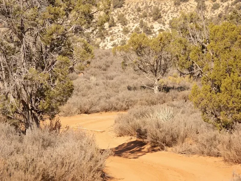
The journey is a study in ecological diversity. It begins (for northbound hikers) in the scorched, cactus-strewn landscapes of the Bootheel in New Mexico, where water management is the primary survival skill. It then ascends into the Gila Wilderness, the world's first designated wilderness area, where the trail weaves through deep canyons and river crossings. As hikers move north, the terrain transforms into the massive, snow-capped peaks of the San Juan Mountains in Colorado, offering some of the most spectacular alpine scenery on Earth. The trail then crosses the vast, arid expanse of the Great Divide Basin in Wyoming—a high-altitude desert where the divide splits and creates a closed drainage basin—before entering the jagged granite cathedrals of the Wind River Range. The final stages take hikers through the remote Bitterroot Mountains along the Idaho-Montana border and finally into the crown jewel of the National Park system: Glacier National Park.
Completing the CDT requires more than just physical fitness; it requires a high degree of mental resilience. Hikers must contend with grizzly bears in the northern sections, violent afternoon lightning storms in the high alpine, and the constant logistical pressure of resupplying in remote mountain towns. However, the reward is a level of solitude and wilderness immersion that is increasingly rare. On the CDT, it is possible to walk for days without seeing another human being, surrounded only by the silence of the high peaks and the vastness of the American West.
History and Cultural Context
The concept of a trail following the Continental Divide was first formally proposed in the mid-1960s, inspired by the success of the Appalachian Trail. However, it wasn't until the National Trails System Act was amended in 1978 that the Continental Divide National Scenic Trail was officially established by Congress. Unlike the AT or PCT, which had established corridors and strong volunteer bases early on, the CDT struggled for decades with funding, land access, and a lack of dedicated tread. For many years, the "trail" was little more than a line on a map, forcing early pioneers to piece together forest service roads, livestock paths, and cross-country routes.
The cultural history of the land the trail traverses is deep and multifaceted. Long before European explorers arrived, the Continental Divide served as a landmark and seasonal migration route for numerous Indigenous peoples, including the Apache, Navajo (Diné), Pueblo, Ute, Shoshone, Blackfeet (Amskapi Piikani), and Nez Perce (Nimiipuu). These mountains were, and remain, sacred spaces for spiritual practice, hunting, and gathering. The trail also passes through the remnants of the American frontier—abandoned mining camps in Colorado, historic cattle drive routes in Wyoming, and the paths taken by Lewis and Clark in Montana. The Continental Divide Trail Coalition (CDTC), formed in 2012, now works to complete the trail, protect its corridor, and recognise the diverse human histories embedded in the landscape.
Today, the CDT is approximately 95% protected, though significant "road walks" still exist in certain sections. The effort to complete the trail is one of the largest conservation projects in North America, involving federal agencies, state governments, and thousands of volunteers. Walking the CDT is, in many ways, a journey through the history of American conservation and the evolving relationship between the public and the wilderness.
Want more background? Read extended notes on history and cultural context → Learn more
Seasonal Highlights and Weather Reality
Timing is the most critical factor in a successful CDT thru-hike. The "weather window" for the Rockies is notoriously narrow. Northbound (NOBO) hikers typically start at the Mexican border in mid-April to early May. Starting earlier risks encountering impassable snow in the San Juan Mountains of Colorado, while starting later leaves hikers vulnerable to early autumn snowstorms in Montana's Glacier National Park. Southbound (SOBO) hikers usually wait until mid-to-late June for the snow to melt in Glacier, but they must then race to beat the winter snows in the high peaks of Colorado.
Spring (April–May): In New Mexico, this is the season of heat and wind. Daytime temperatures in the desert can exceed 30°C, while nights can drop below freezing. Water sources are at their most precarious, and hikers must often rely on "water caches" maintained by volunteers. This is also the time when the Gila River is at its highest due to snowmelt, making the numerous river crossings challenging.
Summer (June–August): This is the peak season for the high country. In Colorado, the primary weather threat is the "monsoon" season—afternoon thunderstorms that roll in with terrifying consistency. Hikers must aim to be off high ridges and peaks by noon to avoid lightning. In Wyoming and Montana, summer brings the beauty of alpine wildflowers but also the threat of wildfires, which can lead to trail closures and hazardous smoke levels. This is also when mosquitoes and biting flies are at their most aggressive in the Wind River Range and the northern forests.
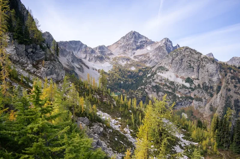
Autumn (September–October): For those still on the trail, autumn offers crisp air, golden aspen trees, and the bugling of elk. However, it is a season of high stakes. A single "upslope" storm can dump a metre of snow in the mountains, effectively ending a thru-hike. Hikers in Montana or Colorado during this time must be prepared for sub-zero temperatures and rapidly deteriorating conditions.
Recommended Itinerary
The Five-State Route Progression
Section 1: New Mexico (The Desert and the Gila)
- Distance: ~1,250 km
- Key Waypoints: Crazy Cook (Border), Lordsburg, Silver City, Gila Cliff Dwellings, Pie Town, Ghost Ranch, Chama
- Terrain: Arid desert flats, volcanic malpais, deep river canyons, and high mesas
- Highlights: The Gila River alternate (over 150 river crossings), the unique hospitality of Pie Town, and the red rock beauty of Ghost Ranch
- Challenge: Water scarcity in the Bootheel and the navigational complexity of the Cebolla Wilderness
Section 2: Colorado (The High Country)
- Distance: ~1,200 km
- Key Waypoints: Cumbres Pass, Pagosa Springs, Silverton, Lake City, Salida, Leadville, Grand Lake, Steamboat Springs
- Terrain: High alpine ridges, glacial cirques, and dense subalpine forest
- Highlights: The San Juan Mountains (the most sustained high-altitude section), crossing the 4,000 m mark, and the historic mining town of Leadville (the highest city in the USA)
- Challenge: Sustained elevation (often above 3,500 m), afternoon lightning, and the potential for heavy snowpack in early summer
Section 3: Wyoming (The Basin and the Winds)
- Distance: ~820 km
- Key Waypoints: Encampment, Rawlins, Atlantic City, Pinedale, Dubois, Yellowstone National Park
- Terrain: High desert plains, jagged granite peaks, and geothermal basins
- Highlights: The Great Divide Basin (wild horses and vast horizons), the Wind River Range (arguably the most beautiful mountains on the trail), and the geysers of Yellowstone
- Challenge: Extreme exposure and lack of water in the Basin; grizzly bear territory begins in the northern Winds
Section 4: Idaho/Montana (The Bitterroots)
- Distance: ~800 km (along the border)
- Key Waypoints: Lima, Leadore, Darby, Sula, Anaconda
- Terrain: Remote, forested ridges and long stretches of the Idaho-Montana state line
- Highlights: The Big Hole Valley, the remote Selway-Bitterroot Wilderness, and the unique "roller coaster" topography of the border ridges
- Challenge: Extremely remote resupplies, overgrown trail sections, and significant cumulative elevation gain/loss
Section 5: Northern Montana (The Crown of the Continent)
- Distance: ~650 km
- Key Waypoints: Helena, Augusta, East Glacier Park, Waterton Lakes (Canada)
- Terrain: Limestone reefs, expansive wilderness, and dramatic glacial valleys
- Highlights: The Chinese Wall in the Bob Marshall Wilderness (a 35 km long, 300 m high limestone escarpment) and the turquoise lakes of Glacier National Park
- Challenge: High grizzly bear density, unpredictable weather, and the emotional weight of the final kilometres
Important Notes:
- The CDT is a "choose your own adventure" trail; distances vary based on whether you take "official" routes or popular alternates (like the Gila River or Knapsack Col)
- Resupply points can be over 150 km apart, requiring 5–7 days of food carriage
- Navigation via the FarOut app and paper map backups is essential
- Grizzly bear canisters or Ursacks are required in Wyoming, Idaho, and Montana
Planning and Bookings
Book Your Trip
Everything you need to plan your journey
Accommodation
Find places to stay near Denver, Colorado
Flights
Search flights to Denver, Colorado
Essential Preparation
Planning for the CDT is a massive undertaking that usually begins a year in advance. Unlike the PCT, there is no single "CDT Permit" that covers the entire journey. Hikers must coordinate multiple permits for National Parks and specific wilderness areas. Physical preparation should focus on cardiovascular endurance and, crucially, leg strength to handle the massive elevation changes. However, no amount of training can fully prepare a hiker for the sustained altitude of Colorado; acclimatisation is a process that happens on the trail.
Logistics involve deciding between a Northbound (NOBO) or Southbound (SOBO) direction. NOBO is more traditional, allowing hikers to "walk into shape" in the relatively flatter New Mexico desert before hitting the Colorado peaks. SOBO is often chosen by experienced hikers who want to avoid the "bubble" of other trekkers or who have a later start date. Resupply strategy is another pillar of preparation: many hikers use a mix of "mailing boxes" to remote outposts (like Pie Town or Atlantic City) and buying food in larger towns (like Silver City or Steamboat Springs).
Trail Accommodation
The vast majority of accommodation on the CDT is wild camping on public lands (National Forest or Bureau of Land Management land). This offers incredible freedom but requires strict adherence to Leave No Trace principles.
Camping and Shelters:
- Wild Camping: Available on most of the trail. Hikers must find established sites or durable surfaces.
- National Park Campgrounds: In Glacier, Yellowstone, and Rocky Mountain National Parks, you MUST stay in designated backcountry sites, which require specific permits.
- Trail Towns: Hikers typically "zero" (take a rest day) in towns, staying in motels, hostels, or "trail angel" houses.
- Huts/Shelters: Unlike the Appalachian Trail, there are almost no dedicated trail shelters on the CDT. Hikers must carry their own tent or tarp.
What's Provided:
- In towns: Standard amenities (showers, laundry, WiFi).
- In National Parks: Some backcountry sites have bear poles or food lockers and pit toilets.
- On the trail: Nothing. You are responsible for your own shelter, water, and safety.
Required Gear
- Ultralight Tent or Tarp - Must be wind-resistant for high alpine exposure.
- Sleeping System - A quilt or bag rated to at least -7°C (-6°C); even in summer, mountain temperatures plummet.
- Backpack - 50–70L capacity, lightweight but capable of carrying up to 7 days of food and 4–6 litres of water.
- Footwear - Most thru-hikers use trail running shoes for breathability, though some prefer boots for the rocky Colorado sections. Expect to go through 4–6 pairs.
- Navigation - Smartphone with FarOut app, external power bank (20,000 mAh), and paper maps/compass as backup.
- Satellite Messenger - Garmin inReach or similar for emergency communication in "dead zones."
- Ice Axe and Microspikes - Essential for Colorado (NOBO) or Glacier (SOBO) if snow levels are high.
- Bear Protection - Bear spray is mandatory in MT/WY/ID. A bear-resistant canister or Ursack is required in many sections.
What to Bring
- Water Filtration - A hollow-fibre filter (like a Sawyer Squeeze) is the industry standard. Carry backup chemical treatment (AquaMira).
- Clothing Layers - Merino wool base layers, a "puffy" down jacket, and a high-quality rain shell (Gore-Tex or similar).
- Sun Protection - Wide-brimmed hat, polarised sunglasses, and sun hoodie. The UV radiation at 4,000 m is intense.
- First Aid - Focus on blister care (Leukotape), anti-inflammatories, and any personal prescriptions.
- Repair Kit - Tenacious Tape, needle and thread, and sleeping pad patches.
- Toiletries - Trowel for digging cat-holes, biodegradable soap, and hand sanitiser.
- Food - High-calorie, low-weight items (nuts, dried fruit, tortillas, peanut butter, dehydrated meals). Aim for 3,500–5,000 calories per day.
Permits
There is no single "Golden Ticket" permit for the CDT. Instead, hikers must manage a patchwork of regulations. For the majority of the trail (National Forest and BLM land), no permit is required for walking or camping. However, several key areas have strict requirements that must be organised in advance or at specific trail junctions.
National Park Permits:
- Glacier National Park: Requires a backcountry permit for specific campsites. These are highly competitive. Hikers can apply for an advance reservation or attempt to get a "walk-in" permit at a ranger station.
- Yellowstone National Park: Requires a backcountry permit for overnight stays. Like Glacier, these are site-specific.
- Rocky Mountain National Park: Required for camping within park boundaries. Many hikers choose to walk through the park in a single day to avoid the permit hassle.
Other Specific Permits:
- New Mexico State Lands: A specific recreational permit is required to cross state-owned land in New Mexico. This can be purchased online through the NM State Land Office.
- Blackfeet Indian Reservation: If taking certain alternates in Montana, a tribal recreation permit is required.
- Canada Entry: If finishing at Waterton Lakes and crossing the border, hikers must have a valid passport and may need to use the ArriveCAN app or follow specific port-of-entry protocols.
The CDTC Long Distance Permit: While not a "legal" requirement for the whole trail, the Continental Divide Trail Coalition offers a voluntary long-distance permit that helps the organisation track trail usage and advocate for funding. It does NOT replace the National Park permits mentioned above.
Other Activities in the Area
The CDT corridor passes through some of the most iconic outdoor recreation hubs in the United States. If you have extra time or are taking a "double zero," consider these activities:
- Peak Bagging in Colorado: The trail passes near many "Fourteeners" (peaks over 4,267 m / 4,267 m). Mount Elbert and Grays Peak are popular side trips.
- Hot Springs: Relax sore muscles at Pagosa Springs (CO), Princeton Hot Springs (CO), or the boiling rivers of Yellowstone (WY).
- Mountain Biking: Towns like Salida, Steamboat Springs, and Helena offer world-class mountain bike trails if you want a different way to move.
- Fly Fishing: The Gila River, the Wind River Range, and the streams of Montana offer some of the best trout fishing in the world.
- Historic Tours: Visit the Gila Cliff Dwellings National Monument or the ghost towns of the Colorado Rockies to see the remnants of ancient and pioneer history.
Safety and Conditions
Wildlife Safety: The CDT is "Grizzly Country" from the Wind River Range in Wyoming all the way to the Canadian border. Hikers must practice strict food storage (using bear canisters or hanging bags) and carry bear spray in an accessible location. Black bears are present along the entire trail. Additionally, hikers in the desert sections must be wary of rattlesnakes and scorpions.
Environmental Hazards: Lightning is a primary killer in the Rockies. The "noon rule" (being off the ridges by midday) is a life-saving practice during the summer monsoon season. Hypothermia is a risk even in July if a cold rain catches a hiker at high altitude. In the desert, dehydration and heatstroke are the primary concerns; hikers must sometimes carry 6–8 litres of water to bridge long gaps between sources.
Navigation and Rescue: Because the trail is often poorly marked, getting lost is a genuine possibility. Always carry a satellite messenger (like a Garmin inReach) for emergencies. Cell phone service is non-existent for 90% of the trail. If you become lost, the standard advice is "S.T.O.P." (Sit, Think, Observe, Plan). Do not descend into unknown drainage basins, as these often lead to impassable cliffs or "dead ends."
Altitude Sickness: Acute Mountain Sickness (AMS) can affect anyone, regardless of fitness. Symptoms include headache, nausea, and dizziness. The only cure is to descend to a lower elevation. Hikers should be aware of the more serious conditions, HAPE and HACE, which are medical emergencies.
Side Trips and Points of Interest
The Gila River Alternate: Most hikers choose this route over the "official" CDT in New Mexico. It involves walking directly up the Gila River canyon, crossing the water hundreds of times. It is a lush, shaded oasis in the desert and passes near the Gila Cliff Dwellings.
The Cirque of the Towers: Located in the Wind River Range, this is a spectacular circle of jagged granite peaks. While it requires a strenuous alternate route (the Texas Pass/Jackass Pass route), it is widely considered the single most beautiful spot on the entire 4,989 km journey.
Knapsack Col: Another Wind River alternate that takes hikers over a high alpine pass and past the massive Titcomb Basin. This is true cross-country travel over talus and snow, offering a raw mountain experience far removed from any maintained trail.
The Chinese Wall: In the Bob Marshall Wilderness of Montana, the trail follows the base of a massive limestone escarpment for kilometres. It is a geological marvel and a prime spot for spotting mountain goats and elk.
Leave No Trace
The CDT traverses some of the most fragile ecosystems in North America. High alpine tundra, once damaged by a footprint, can take decades to recover due to the short growing season. In the desert, "cryptobiotic soil" (a living crust) is essential for preventing erosion and must never be stepped on.
The Seven Principles on the CDT:
- Plan Ahead and Prepare: Know the regulations for each National Park and Wilderness area.
- Travel and Camp on Durable Surfaces: Use established campsites. In the backcountry, camp on rock, gravel, or dry grass.
- Dispose of Waste Properly: Dig a cat-hole 15–20 cm deep for human waste, at least 60 m from water. Pack out ALL trash, including toilet paper and fruit peels.
- Leave What You Find: Do not pick wildflowers or remove archaeological artefacts (like arrowheads or pottery shards).
- Minimise Campfire Impacts: Use a stove for cooking. Campfires are often banned due to high wildfire risk; if allowed, use only established fire rings.
- Respect Wildlife: Observe from a distance. Never feed animals, as "a fed bear is a dead bear."
- Be Considerate of Other Visitors: Yield to uphill hikers and pack animals (horses/mules). Keep noise levels low to preserve the sense of solitude.