
Conguillío Volcano Trail - Chile's Volcanic Wonderland
The Conguillío Volcano Trail, nestled within the Conguillío National Park in Chile's Araucanía Region, offers a dramatic and unforgettable hiking experience. This challenging trek circumnavigates the imposing Llaima Volcano, a stratovolcano that has shaped the very landscape it stands upon. The trail winds through ancient Araucaria (monkey puzzle) forests, across vast lava fields, and past turquoise glacial lakes, providing a unique glimpse into a dynamic, geologically active environment. It's a journey that combines raw natural beauty with the palpable power of volcanic forces, offering a profound connection to the earth's elemental processes.
- Distance: 18.0 km (loop)
- Elevation Gain: 1000 m
- Duration: 6-7 hours
- Difficulty: Challenging
- Best Time: November–March (Spring to Autumn)
- Closest City: Melipeuco
- Trailhead Access: Nearest airport: Temuco (ZCO). From Temuco, take a bus to Melipeuco (2 hours). From Melipeuco, hire a taxi or drive (45 min) to Conguillío National Park. Road is partially unpaved. Parking available at the trailhead. Park entrance fee/registration required.
- Coordinates: -38.6589, -71.6932
Overview
The Conguillío Volcano Trail is a testament to nature's resilience and artistry. This circular route, approximately 18 kilometres in length, is a challenging but immensely rewarding exploration of a landscape sculpted by volcanic activity. The trail begins its ascent, gradually gaining elevation as it leads hikers through the iconic Araucaria forests, also known as monkey puzzle trees. These ancient conifers, with their distinctive spiky foliage, create an almost prehistoric atmosphere, a stark contrast to the more recent volcanic terrain that characterises much of the park.
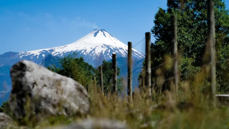
As the trail progresses, it emerges from the dense forest onto the stark, rugged beauty of lava fields. These expanses of solidified molten rock, ranging in colour from deep black to rusty red, bear witness to Llaima Volcano's fiery past. The path here can be uneven and demanding, requiring careful footing and a good level of fitness. The panoramic views that unfold from these higher elevations are breathtaking, offering sweeping vistas of the surrounding volcanic peaks, including the majestic Llaima itself, often capped with snow even in warmer months.
The trail also leads hikers to the shores of stunning glacial lakes, such as Laguna Verde and Laguna Azul. These bodies of water, with their vibrant turquoise and deep blue hues, provide a striking visual counterpoint to the dark volcanic rock and the deep green of the forests. The reflections of the volcanoes and the sky on their still surfaces create moments of serene beauty amidst the ruggedness.
The Conguillío Volcano Trail is not merely a physical challenge; it is an immersive experience in a living geological laboratory. The constant presence of Llaima Volcano, a powerful and active entity, imbues the hike with a sense of awe and respect for the natural world. The trail's demanding nature, with its significant elevation gain and varied terrain, ensures that only well-prepared hikers should attempt it. However, for those who are ready, the rewards are immense: unparalleled scenery, a deep appreciation for volcanic landscapes, and the satisfaction of conquering a truly spectacular trail.
History and Cultural Context
The Conguillío National Park and its surrounding region are steeped in history, both geological and human. The dominant feature, Llaima Volcano, is one of Chile's most active volcanoes, with its last major eruption occurring in 2008. Its fiery history has profoundly shaped the landscape, creating the unique geological formations and ecosystems that hikers encounter today. The park itself was established in 1950 to protect these remarkable volcanic features and the ancient Araucaria forests.
For centuries, the Mapuche people, the indigenous inhabitants of this region, have lived in harmony with the land and its powerful natural forces. Llaima Volcano, known as "Llaimall" in Mapudungun, holds significant cultural and spiritual importance for them. It is seen not just as a geological entity but as a living being, a source of power and a guardian of the land. The Mapuche have a deep understanding of the volcano's cycles and have developed traditional practices and beliefs around its presence. Their ancestral territories encompass the park's lands, and their cultural heritage is intrinsically linked to the natural environment.
The Araucaria forests, with their ancient trees, are also of historical significance. These "monkey puzzle" trees have survived for millennia, predating many of the more recent volcanic events. They are a symbol of resilience and longevity, a living link to prehistoric times. The establishment of Conguillío National Park was a crucial step in preserving these unique forests and the diverse wildlife they support, including the endangered huemul deer and various bird species.
The development of the Conguillío Volcano Trail as a marked hiking route reflects a growing appreciation for the park's natural and cultural heritage. It allows visitors to experience the dramatic volcanic landscapes and the ancient forests in a structured and relatively safe manner, while also encouraging respect for the environment and its indigenous history. The trail serves as a pathway not only through physical terrain but also through layers of geological time and human cultural connection.
Seasonal Highlights and Weather Reality
The best time to hike the Conguillío Volcano Trail is during the Southern Hemisphere's spring and summer, from November to March. This period offers the most stable weather conditions and the highest likelihood of clear skies, allowing for spectacular views of Llaima Volcano and the surrounding landscape.
Spring (November–December): This is a beautiful time to visit as the park awakens from winter. Wildflowers begin to bloom, adding splashes of colour to the volcanic terrain. The weather is generally mild, though occasional rain showers are still possible. Snow may still be present at higher elevations, particularly on Llaima Volcano itself, adding a dramatic visual element.
Summer (January–March): These months offer the warmest temperatures and the longest daylight hours, ideal for extended hikes. The weather is typically drier, but it's crucial to be prepared for sudden changes. Afternoon thunderstorms can occur, bringing heavy rain and lightning. The lava fields can become quite hot under the midday sun, so starting early is advisable.
Autumn (April–May): While less common for hiking the full trail due to cooler temperatures and increased rainfall, autumn can offer stunning foliage colours in the Araucaria forests. However, snow can begin to fall at higher elevations, making the trail more challenging and potentially impassable.
Winter (June–October): Conguillío National Park is largely inaccessible during winter due to heavy snowfall. The roads can be closed, and the trails are covered in snow, requiring specialised winter mountaineering equipment and expertise. This season is not suitable for the Conguillío Volcano Trail.
Weather Considerations: The weather in the Andes can be unpredictable and change rapidly. Even during the summer months, hikers should be prepared for a wide range of conditions, including strong winds, rain, and significant temperature drops, especially at higher elevations. Layering clothing is essential, and always carry waterproof and windproof outer layers.
Recommended Itinerary
Conguillío Volcano Trail - Day Hike Itinerary
Early Morning (Approx. 8:00 AM): Arrival and Trailhead Preparation
- Arrive at the Conguillío National Park entrance. Complete registration and pay the park entrance fee.
- Drive to the designated trailhead parking area (e.g., near Laguna Verde or a specific starting point for the loop).
- Final gear check: ensure water bottles are full, snacks are accessible, and all safety equipment is ready.
- Apply sunscreen and insect repellent.
Morning (Approx. 8:30 AM - 12:00 PM): Ascent through Araucaria Forests
- Begin the hike, typically starting with a climb through the ancient Araucaria (monkey puzzle) forests.
- The trail is well-marked but can be uneven, with roots and rocks.
- Experience the unique, almost prehistoric atmosphere of the forest.
- Gradually gain elevation, with occasional clearings offering glimpses of Llaima Volcano.
- Distance covered: Approximately 6-8 km.
- Elevation gain: Approximately 400-500 m.
Midday (Approx. 12:00 PM - 1:30 PM): Lava Fields and Panoramic Views
- Emerge from the forest onto the stark, rugged lava fields.
- The terrain becomes more exposed and challenging, requiring careful footing.
- Enjoy expansive panoramic views of Llaima Volcano and the surrounding volcanic landscape.
- Find a suitable spot for a packed lunch, taking in the dramatic scenery.
- Distance covered: Approximately 3-4 km.
- Elevation gain: Variable, with some ascents and descents.
Afternoon (Approx. 1:30 PM - 4:30 PM): Lakeside Exploration and Descent
- The trail may lead past or near glacial lakes such as Laguna Verde or Laguna Azul.
- Admire the vibrant colours of the lakes against the dark volcanic rock.
- Begin the descent, which can be steep in sections.
- The path may lead back through mixed forest or continue across more open terrain.
- Distance covered: Approximately 6-8 km.
- Elevation loss: Approximately 500-600 m.
Late Afternoon (Approx. 4:30 PM - 5:00 PM): Return to Trailhead
- Arrive back at the trailhead parking area.
- Complete the hike, ensuring all litter is packed out.
- Allow time for rest and reflection on the day's adventure.
Important Notes:
- This is a challenging day hike requiring good physical fitness.
- Carry sufficient water (at least 2-3 litres per person) as water sources may be scarce or unreliable.
- Pack a substantial lunch and snacks.
- Be prepared for rapidly changing weather conditions.
- Wear sturdy, broken-in hiking boots.
- Inform someone of your hiking plans and expected return time.
- Mobile phone reception is likely to be very limited or non-existent within the park.
Planning and Bookings
Book Your Trip
Everything you need to plan your journey
Accommodation
Find places to stay near Melipeuco
Flights
Search flights to Melipeuco
Essential Preparation
Planning your visit to Conguillío National Park requires attention to logistics, especially regarding access and park regulations. The nearest major city with an airport is Temuco. From Temuco, you can take a bus to the small town of Melipeuco, which serves as a gateway to the park. The final leg of the journey from Melipeuco to the park entrance and trailheads involves a drive of approximately 45 minutes. Be aware that sections of this road are unpaved and can be rough, particularly after rain, so a vehicle with good clearance is recommended if driving yourself. If relying on public transport, pre-booking taxis or arranging private transfers from Melipeuco is advisable.
Upon arrival at the park entrance, you will need to register and pay an entrance fee. It is essential to check the park's official website or contact the park administration for the most up-to-date information on opening hours, fees, and any specific regulations or alerts before your visit. Parking is available at various points within the park, including near popular trailheads like Laguna Verde. Given the park's remote location, it's wise to have all your supplies, including food, water, and fuel, before you arrive in Melipeuco, as options within the park are extremely limited.
Trail Accommodation
The Conguillío Volcano Trail is primarily a day hike, and therefore, no overnight accommodation is required along the trail itself. Hikers typically base themselves in nearby towns such as Melipeuco or Temuco and undertake the trail as a day excursion. Conguillío National Park does offer camping facilities within its boundaries for those wishing to extend their stay and explore other areas of the park. These campsites usually have basic amenities such as toilets and designated camping areas, but require advance booking, especially during peak season. For the Conguillío Volcano Trail specifically, it is a day hike requiring no overnight accommodation.
Required Gear
- Sturdy Hiking Boots: Waterproof, ankle-supporting boots are essential for navigating the varied and often uneven terrain, including lava fields and forest paths. Ensure they are well broken-in to prevent blisters.
- Waterproof and Windproof Jacket: The weather in the Andes can change rapidly. A high-quality waterproof and windproof jacket is crucial for protection against rain and strong winds.
- Waterproof Overtrousers: Essential for staying dry during unexpected downpours, especially when hiking through exposed areas.
- Warm Layers: Even in summer, temperatures can drop significantly, particularly at higher elevations. Bring insulating layers such as fleece or a down jacket, and a warm hat and gloves.
- Sun Protection: A wide-brimmed hat, sunglasses, and high SPF sunscreen are necessary, as the sun can be intense, especially at altitude and reflected off volcanic rock.
- Navigation Tools: While the Conguillío Volcano Trail is generally well-marked, it's wise to carry a map of the park and a compass, or a GPS device with the trail downloaded. Mobile phone signal is unreliable.
- First-Aid Kit: A comprehensive kit including bandages, antiseptic wipes, pain relievers, blister treatment, and any personal medications.
- Head Torch: With spare batteries, in case your hike takes longer than expected or for early morning starts.
What to Bring
- Food: Pack a substantial lunch, high-energy snacks (nuts, dried fruit, energy bars), and consider bringing extra food in case of delays. There are no food services along the trail.
- Water: Carry at least 2-3 litres of water per person. While there may be streams, it is strongly recommended to treat all water before drinking using a filter or purification tablets.
- Backpack: A comfortable daypack (25-35 litres) to carry all your gear, with a rain cover.
- Insect Repellent: Especially important during warmer months to ward off biting insects.
- Trekking Poles: Highly recommended for stability on steep ascents and descents, and for reducing strain on knees.
- Camera: To capture the spectacular volcanic landscapes and unique flora.
- Toiletries: Biodegradable soap, hand sanitiser, and toilet paper (pack out all used toilet paper).
- Small Towel: For drying hands or wiping sweat.
- Emergency Whistle: For signalling in case of emergency.
Permits
Access to Conguillío National Park requires payment of an entrance fee. This fee contributes to the maintenance and conservation of the park's natural resources. It is advisable to check the official CONAF (Corporación Nacional Forestal) website or contact the park administration for the most current fee structure and payment methods. Typically, fees can be paid at the park entrance station upon arrival.
For the Conguillío Volcano Trail itself, no specific hiking permit is required beyond the general park entrance fee. However, it is always recommended to register your hike at the park's information centre or trailhead, especially for longer or more challenging routes. This helps park authorities monitor visitor numbers and provides a point of contact in case of emergencies.
Important Considerations:
- Park Entrance Fee: This is mandatory for all visitors entering Conguillío National Park.
- Registration: While not always strictly enforced for day hikes, registering your intended route and expected return time at the park office or trailhead is a good safety practice.
- Group Size: There are generally no strict limits on the size of day hiking groups, but it's good practice to keep groups manageable for safety and environmental impact.
- Advance Booking: For camping facilities within the park, advance booking is usually required, especially during peak season (November to March). Check the CONAF website for booking procedures.
Other Activities in the Area
Conguillío National Park and its surroundings offer a wealth of activities for nature enthusiasts:
- Laguna Verde and Laguna Azul: These stunning glacial lakes are easily accessible and offer opportunities for photography, picnicking, and enjoying the serene mountain scenery. Short walks around their perimeters are also available.
- Camping: For those who wish to immerse themselves more deeply in the park's environment, Conguillío offers several well-maintained campgrounds. These provide a base for exploring other trails and enjoying the park's nocturnal beauty.
- Wildlife Viewing: The park is home to a diverse array of fauna. Keep an eye out for the endangered huemul deer, various bird species including the Magellanic woodpecker, and smaller mammals.
- Photography: The dramatic volcanic landscapes, ancient forests, and vibrant lakes provide endless opportunities for photographers of all levels.
- Exploring Melipeuco: The nearby town of Melipeuco offers a glimpse into local Chilean culture. It has basic amenities, restaurants, and serves as a convenient base for accessing the park.
- Other Trails: Conguillío National Park features a network of other hiking trails, ranging from short interpretive walks to more strenuous multi-day routes, allowing for deeper exploration of its diverse ecosystems.
Safety and Conditions
Pre-Departure Checks:
- Weather Forecast: Always check the most up-to-date weather forecast for the Conguillío region before your hike. Be prepared for rapid changes, especially in the mountains. MetService or local Chilean meteorological services are good resources.
- Park Alerts: Visit the official CONAF website for Conguillío National Park for any alerts, trail closures, or specific advisories. Volcanic activity, though infrequent, can lead to temporary closures.
- Road Conditions: If driving, be aware that the unpaved sections of the road to the park can become challenging, especially after rain. Check local road conditions if possible.
Trail Hazards:
- Volcanic Terrain: Lava fields can be sharp, unstable, and difficult to traverse. Wear sturdy footwear and watch your step carefully.
- Steep Ascents and Descents: The trail involves significant elevation changes, which can be demanding on the legs and knees. Trekking poles are highly recommended.
- Unpredictable Weather: Hypothermia is a risk even in summer due to sudden drops in temperature, wind, and rain. Always carry adequate layers and waterproofs.
- Sun Exposure: The sun can be intense at higher altitudes, and there is little shade on the lava fields. Protect yourself from sunburn.
- Water Sources: While streams may be present, it is crucial to treat all water before consumption to avoid waterborne illnesses.
Emergency Preparedness:
- Inform Someone: Always let a trusted person know your hiking plans, including your intended route, start time, and expected return time.
- Mobile Phone: Mobile phone reception is extremely limited or non-existent within the park. Do not rely on your phone for communication in an emergency.
- First-Aid Kit: Carry a well-stocked first-aid kit and know how to use its contents.
- Emergency Contact: Know the emergency contact number for CONAF or local emergency services in Chile.
- Stay on Trail: Stick to marked trails to avoid getting lost and to protect the fragile environment.
Wildlife: While generally not aggressive, be aware of local wildlife. Do not approach or feed animals. The park is home to various bird species, and occasionally larger mammals like the huemul deer.
Side Trips and Points of Interest
Llaima Volcano Summit (Advanced): For experienced mountaineers with appropriate gear and knowledge, a guided ascent to the summit of Llaima Volcano is a possibility. This is a serious undertaking requiring technical climbing skills, ice axe, crampons, and a high level of fitness, as well as knowledge of volcanic environments. It is not part of the standard Conguillío Volcano Trail and should only be attempted with experienced guides.
Laguna Verde and Laguna Azul Shoreline Walks: While the main trail may pass by these lakes, taking time for short, leisurely walks along their shores offers different perspectives and photographic opportunities. The vibrant colours of the water against the stark volcanic backdrop are particularly striking.
Araucaria Forest Exploration: The ancient Araucaria (monkey puzzle) forests are a highlight of Conguillío. Take moments to appreciate the unique structure and resilience of these trees. Some areas may have interpretive signs detailing their ecological significance and history.
Lava Tube Formations: In certain areas of the park, evidence of past lava flows can be seen in the form of solidified lava tubes and interesting rock formations. These are fascinating geological features that tell the story of the volcano's activity.
Mirador Volcán Llaima: Several viewpoints along the trail offer spectacular vistas of Llaima Volcano. These designated "miradores" (viewpoints) are ideal spots to pause, rest, and absorb the grandeur of the landscape.
Leave No Trace
The Conguillío Volcano Trail traverses a unique and fragile volcanic ecosystem. Adhering to Leave No Trace principles is paramount to preserving its natural beauty and ecological integrity for future generations. As a visitor, you play a vital role in protecting this environment.
Your responsibility as a hiker:
- Plan Ahead and Prepare: Understand the trail's challenges, weather conditions, and park regulations before you go. Pack appropriately and be prepared for all conditions.
- Travel and Camp on Durable Surfaces: Stick to the marked trails. Avoid walking on vegetation, especially the delicate mosses and lichens found in the volcanic areas. If camping (outside the main trail), use designated campsites.
- Dispose of Waste Properly: Pack out everything you pack in. This includes all food scraps, wrappers, and any other litter. Use designated toilets where available, or dig catholes at least 70 metres away from water sources, trails, and campsites. Pack out all toilet paper.
- Leave What You Find: Do not remove any natural objects, such as rocks, plants, or cultural artifacts. Take only photographs and memories.
- Minimise Campfire Impacts: Campfires are generally not permitted on the Conguillío Volcano Trail. If camping elsewhere in the park, use established fire rings and ensure fires are completely extinguished.
- Respect Wildlife: Observe wildlife from a distance. Never feed animals, as this can disrupt their natural behaviours and diets, and can be harmful to their health.
- Be Considerate of Other Visitors: Keep noise levels down, yield to other hikers, and maintain a respectful attitude towards the natural environment and fellow visitors.
By following these principles, you help ensure that the Conguillío Volcano Trail remains a pristine and awe-inspiring destination.