Andes Condor Trail Segment - The Spine of the Equator
The Andes Condor Trail Segment is a monumental high-altitude thru-hike that traverses the rugged, volcanic heart of Ecuador. Stretching approximately 1,200 kilometres along the dramatic "Avenue of Volcanoes," this route offers an unparalleled journey through one of the most geologically active and biologically diverse mountain ranges on Earth. Starting from the remote village of Oyacachi and winding southwards, the trail navigates a labyrinth of high-altitude grasslands known as paramo, skirts the glaciated flanks of massive stratovolcanoes, and descends into deep, mist-shrouded cloud forests. This is not merely a hike; it is a multi-month expedition that demands physical resilience, navigational expertise, and a deep respect for the volatile weather systems of the equatorial Andes.
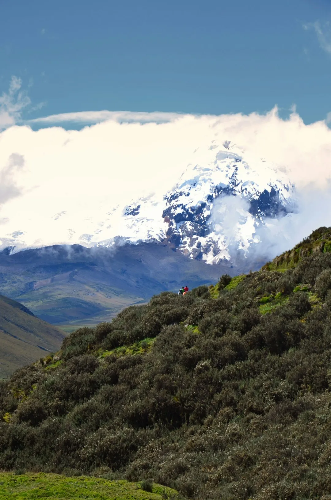
Unlike more established Great Walks, the Condor Trail Segment is a raw and often solitary experience. Walkers will find themselves crossing vast plateaus where the only companions are wild horses, Andean foxes, and the majestic silhouette of the Andean Condor soaring overhead. The trail connects remote indigenous communities, offering a rare glimpse into a way of life dictated by the rhythms of the mountains and the fertility of volcanic soil. With a staggering cumulative elevation gain of 50,000 metres, the route tests the limits of human endurance while rewarding the persistent with vistas of snow-capped giants like Cotopaxi, Chimborazo, and Sangay. It is a journey through the clouds, where the thin air is matched only by the immense scale of the landscape.
- Distance: 1,200.0 km point-to-point
- Duration: 2–3 months
- Season: June to September (dry season; essential for high-altitude safety)
- Accommodation: Remote wild camping, mountain refugios, and village homestays
- Highest point: Approximately 4,800 m (various high passes and volcano flanks)
- Total Elevation Gain: 50,000 m
- Difficulty: Very Challenging (requires advanced navigation and high-altitude experience)
- Direction: North to South (Oyacachi to the southern border regions)
Overview
The Andes Condor Trail Segment represents the pinnacle of South American thru-hiking. It follows the undulating crest of the Ecuadorian Andes, a region defined by its "verticality"—where ecosystems change every few hundred metres of ascent. The trail is characterised by the "Paramo," a unique high-altitude moorland found only in the northern Andes. This landscape is a sponge-like environment of giant rosette plants (frailejones), hardy tussock grasses, and crystalline lagoons. Walking through the paramo is a sensory experience: the ground is often damp and springy, the air is crisp and thin, and the weather can shift from piercing equatorial sun to freezing sleet within minutes. The ecological importance of this region cannot be overstated, as it serves as the primary water source for millions of people living in the valleys below.
The route is strategically designed to showcase the diversity of the Ecuadorian highlands. It passes through several major protected areas, including Cayambe-Coca Ecological Reserve, Antisana Ecological Reserve, Cotopaxi National Park, and Sangay National Park. Each segment offers a different geological flavour. In the north, the terrain is dominated by jagged peaks and ancient caldera lakes. As the trail moves south, it enters the heart of the volcanic corridor, where the perfectly symmetrical cone of Cotopaxi serves as a constant navigational beacon. Further south, the landscape becomes even more remote and rugged, entering the "Altar" region—a collapsed volcano containing a turquoise lagoon surrounded by cathedral-like spires of rock.
Logistically, the trail is a significant undertaking. Resupply points are often separated by five to seven days of strenuous walking through uninhabited terrain. Navigation is frequently difficult, as formal trail markings are non-existent in many sections; hikers must rely on GPS tracks, topographical maps, and an intuitive understanding of the terrain. The physical toll of constant elevation change at altitudes consistently above 3,500 metres requires a slow, disciplined pace and a high degree of self-reliance. However, for those who seek true wilderness and the opportunity to traverse an entire country by foot, the Condor Trail Segment offers a profound connection to the earth's primordial forces.
History and Cultural Context
The path followed by the Condor Trail Segment is steeped in thousands of years of human history. Long before the arrival of the Spanish or even the Inca, indigenous groups such as the Caranqui, Quitu, and Puruhá inhabited these highlands. They developed sophisticated agricultural techniques and established trade routes that crossed the high passes to link the Amazon basin with the Pacific coast. Many sections of the modern trail follow these ancient "Culuncos"—deeply eroded paths carved into the volcanic soil by centuries of foot traffic and pack animals. These sunken trails, often shrouded in overhanging vegetation, feel like tunnels through time.
In the 15th century, the Inca Empire expanded into what is now Ecuador, integrating these local routes into the "Qhapaq Ñan" or Great Inca Road. This vast network of stone-paved roads and tambos (waystations) allowed for the rapid movement of messengers, armies, and goods across the empire. While much of the stone paving has been lost to time or volcanic activity, the strategic logic of the Inca routes remains visible in the trail's progression. The mountains themselves were—and remain—sacred. Known as "Apus" or mountain spirits, peaks like Chimborazo and Tungurahua are central to indigenous cosmology, viewed as powerful deities that control the weather and the fertility of the land.
The modern concept of the Condor Trail was born from a desire to conserve these fragile ecosystems and promote sustainable trekking. By linking existing paths and ancient routes, conservationists and local communities have created a corridor that encourages the protection of the Andean Condor's habitat. The condor, with its three-metre wingspan, is a national symbol of Ecuador and a "vulnerable" species. Seeing one of these birds soaring over the trail is a reminder of the wildness that still exists in the high Andes. Walking this trail is an act of cultural and environmental witness, supporting the communities that act as guardians of the high-altitude water sources and the ancient traditions of the mountains.
Want more background? Read extended notes on history and cultural context → Learn more
Seasonal Highlights and Weather Reality
The equatorial location of the Andes Condor Trail means that "summer" and "winter" do not exist in the traditional sense. Instead, the year is divided into the dry season and the wet season. For a thru-hike of this magnitude, timing is the most critical factor for success and safety.
The Dry Season (June to September): This is the primary window for attempting the trail. During these months, the "Veranillo" (little summer) provides the most stable weather. Days are often characterised by clear, bright blue skies and intense equatorial sun. However, this is also the windiest time of year. The "Vientos de Agosto" (August winds) can be ferocious on high ridges and passes, making tent pitching difficult and increasing the risk of wind chill. Night-time temperatures frequently drop below freezing, especially above 4,000 metres. This season offers the best visibility for navigation and the most spectacular views of the volcanic peaks.
The Shoulder Seasons (October to November and April to May): These periods are unpredictable. You may experience beautiful mornings followed by heavy afternoon thunderstorms. The paramo becomes significantly boggier, making progress slower and more exhausting. Snow is possible on the higher passes, and cloud cover often obscures the landmarks needed for navigation. Only experienced hikers with flexible schedules should consider these months.
The Wet Season (December to March): Attempting a full thru-hike during this period is generally discouraged. Heavy, persistent rain can turn the trail into a quagmire, and river crossings become dangerous or impassable. The risk of landslides in the steeper sections increases, and the constant dampness makes it difficult to maintain body temperature and keep gear dry. Visibility is often near zero for days at a time due to "garúa" (thick mist), which makes navigation in the featureless paramo extremely hazardous.
Regardless of the season, hikers must be prepared for "four seasons in one day." It is common to begin the morning in a frost-covered tent, hike through intense heat at midday, and seek shelter from a hailstorm in the afternoon. The high Andes are a place of extremes, and the weather is the ultimate arbiter of the trail's difficulty.
Recommended Itinerary
Stage 1: The Northern Paramos (Oyacachi to Papallacta)
- Distance: 45 km
- Duration: 3–4 days
- Key Waypoints: Oyacachi Village, Mauca-Machay, Papallacta Pass, Papallacta Hot Springs
- Terrain: High-altitude grasslands and ancient stone paths
- Highlights: Starting in the remote, indigenous village of Oyacachi; soaking in the volcanic hot springs at the end of the stage
- Challenge: Rapid ascent to 4,300 m; often misty and damp
Stage 2: The Antisana Wilderness (Papallacta to Cotopaxi)
- Distance: 85 km
- Duration: 5–7 days
- Key Waypoints: Laguna de Santa Lucía, Antisana Flanks, Sincholagua Base, Cotopaxi North Entrance
- Terrain: Vast, uninhabited paramo plateaus and volcanic scree
- Highlights: Unrivalled views of the massive glaciers of Antisana; spotting wild horses and Andean Condors
- Challenge: Extremely remote; no resupply; difficult navigation across featureless plateaus
Stage 3: The Avenue of Volcanoes (Cotopaxi to Quilotoa)
- Distance: 110 km
- Duration: 6–8 days
- Key Waypoints: Cotopaxi Refugio, Pampa de Limpios, Isinlivi, Chugchilán, Quilotoa Crater
- Terrain: Volcanic ash fields, deep canyons, and rural farmland
- Highlights: Walking beneath the perfect cone of Cotopaxi; the dramatic descent into the Toachi Canyon; the turquoise waters of the Quilotoa caldera
- Challenge: High winds in the Cotopaxi national park; steep climbs in and out of canyons
Stage 4: The High Giants (Quilotoa to Chimborazo)
- Distance: 140 km
- Duration: 8–10 days
- Key Waypoints: Zumbahua, Angamarca, El Arenal, Chimborazo High Plateau
- Terrain: Remote indigenous territories and high-altitude desert
- Highlights: Cultural immersion in Zumbahua; reaching the base of Chimborazo (the point on Earth closest to the sun)
- Challenge: Long distances between water sources in the "El Arenal" desert; very high average altitude
Stage 5: The Altar and Sangay (Chimborazo to Atillo)
- Distance: 160 km
- Duration: 10–12 days
- Key Waypoints: Riobamba (resupply), Laguna Amarilla (El Altar), Sangay National Park, Atillo Lagoons
- Terrain: Glacial valleys, jagged peaks, and pristine alpine lakes
- Highlights: The amphitheatre of El Altar; the wild, untouched beauty of Sangay National Park
- Challenge: Some of the boggiest terrain on the trail; frequent rain even in the dry season
Stage 6: The Southern Highlands (Atillo to Cuenca)
- Distance: 220 km
- Duration: 12–15 days
- Key Waypoints: Ozogoche Lagoons, Achupallas, Ingapirca Ruins, Cajas National Park, Cuenca
- Terrain: Inca roads, paramo, and polylepis forests
- Highlights: Walking the best-preserved sections of the Inca Road; exploring the Ingapirca ruins; the lake-studded landscape of El Cajas
- Challenge: Navigating the complex lake systems of Cajas; long stage requiring careful food management
Stage 7: The Valley of Longevity (Cuenca to Vilcabamba)
- Distance: 240 km
- Duration: 14–18 days
- Key Waypoints: Girón, Saraguro, Podocarpus National Park, Vilcabamba
- Terrain: Cloud forest, lower-altitude valleys, and ridge walks
- Highlights: The unique culture of the Saraguro people; the incredible biodiversity of Podocarpus; finishing in the lush, warm valley of Vilcabamba
- Challenge: Increasing heat and humidity; dense vegetation in the cloud forest sections
Important Notes:
- This is a conceptual breakdown; actual daily distances will vary based on fitness and weather.
- Resupply is only possible in major towns (Papallacta, Latacunga/Quilotoa, Riobamba, Cuenca, Saraguro).
- Water must be treated throughout the entire route due to livestock presence.
- A high-quality GPS with offline maps is mandatory.
Planning and Bookings
Book Your Trip
Everything you need to plan your journey
Accommodation
Find places to stay near Quito
Flights
Search flights to Quito
Essential Preparation
Preparation for the Andes Condor Trail Segment must begin months in advance. The primary challenge is the altitude. It is highly recommended to spend at least 7–10 days in Quito (2,850 m) or similar high-altitude towns before starting, performing day hikes to higher elevations (such as Pichincha or Pasachoa) to acclimatise. Physical fitness must be at an elite level; you will be carrying a heavy pack (15–20 kg) over steep, uneven terrain for weeks on end.
Logistical coordination involves planning resupply points. Many thru-hikers use a combination of buying food in local markets and sending "bounce boxes" to hostels in major towns like Riobamba or Cuenca. Knowledge of basic Spanish is essential for communicating with local communities, arranging transport, and navigating rural areas where English is not spoken. Ensure you have a comprehensive insurance policy that covers high-altitude trekking and emergency helicopter evacuation.
Trail Accommodation
Accommodation on the Condor Trail is a mix of wild camping and occasional formal structures. There is no centralised booking system for the entire route, as it crosses various national parks and private lands.
Wild Camping: This will be your primary form of accommodation. In the paramo and national parks, camping is generally permitted but must follow strict Leave No Trace principles. You must be self-sufficient with a high-quality, 4-season tent capable of withstanding high winds and heavy sleet.
Mountain Refugios: In areas like Cotopaxi and Chimborazo, there are high-altitude refugios. These provide basic bunks and sometimes communal meals. They are often used by climbers and can be crowded. Costs are typically around US$30–$40 per night including dinner and breakfast. Bookings are recommended during weekends or peak holidays.
Village Homestays and Hostels: In the "Quilotoa Loop" section and southern villages, you will find family-run hostels. These are excellent for cultural immersion and a warm bed. Facilities usually include hot showers (sometimes) and hearty local meals. Prices range from US$15 to US$30 per night, often including two meals.
What is NOT provided: Outside of the towns, there are no facilities. No toilets, no treated water, and no electricity. You must be prepared to manage all your needs in a wilderness environment.
Required Gear
- 4-Season Tent: Must be wind-stable and have a high waterproof rating. Double-wall tents are better for managing condensation in the damp paramo.
- Sleeping System: A sleeping bag rated to at least -10°C (comfort) and a high-R-value insulated sleeping pad (R4 or higher) to protect against the frozen ground.
- Footwear: Sturdy, waterproof leather or Gore-Tex tramping boots with deep lugs. The terrain is often boggy, rocky, and abrasive. Bring high-quality gaiters to keep mud and scree out of your boots.
- Navigation: A dedicated GPS device (like Garmin InReach) with extra batteries, plus a smartphone with offline maps (Gaia GPS or AllTrails) and a physical compass/map for backup.
- Backpack: A 60–75L pack with a robust suspension system to handle heavy loads. A waterproof pack liner is more effective than a rain cover in the high Andean winds.
- Clothing: A comprehensive layering system: merino base layers, a heavy fleece or "active" insulation layer, a high-loft down jacket for camp, and a professional-grade hardshell jacket and trousers.
What to Bring
- Food: High-calorie, lightweight dehydrated meals for the remote sections. Supplement with local staples like oats, nuts, and dried fruit found in markets. Carry at least 2 days of emergency rations.
- Water Treatment: A high-flow filter (like Sawyer Squeeze) plus chemical purification tablets (Katadyn Micropur) as a backup. Livestock are present even in remote paramos, making water treatment non-negotiable.
- Cooking: A multi-fuel stove (like MSR WhisperLite) is ideal as white gas or canister gas can be hard to find in smaller towns. If using canisters, ensure you stock up in Quito or Riobamba.
- Power: A large capacity power bank (20,000mAh+) and potentially a portable solar panel for the long, sunny stretches in the north.
- First Aid: A comprehensive kit including blister care, broad-spectrum antibiotics, rehydration salts, and Diamox (acetazolamide) for altitude sickness (consult a doctor first).
- Sun Protection: SPF 50+ sunscreen, lip balm with SPF, and Category 4 sunglasses. The equatorial sun at 4,000 m is exceptionally damaging.
Permits
Ecuador's national park system (SNAP) generally does not require expensive permits for trekking, but there are specific regulations and entry requirements for the various protected areas the Condor Trail crosses. As of current regulations, entry to most national parks in Ecuador is free for both residents and international visitors, but you must register at the entrance stations.
Key Permit and Registration Points:
- Cayambe-Coca & Antisana: You must sign in at the ranger stations (controladores). If you are entering from a remote trail-head like Oyacachi, ensure you check in with the local community leaders or the teniente político.
- Cotopaxi National Park: Registration is mandatory at the north or south gates. If you plan to summit the volcano, you MUST hire a certified ASEGUIM guide; however, for trekking the lower flanks, a guide is not currently required.
- Sangay National Park: This is a high-security area due to volcanic activity. Check with the Ministry of Environment (MAE) office in Riobamba before entering, as certain sectors may be closed due to eruptions.
- Cajas National Park: Registration is required at the Toreadora visitor centre. They have strict limits on the number of overnight campers in certain zones.
Logistical Considerations: While the "permits" are free, the logistics of getting to and from trailheads often involve hiring local 4x4 transport, which can cost between US$40 and US$100 depending on the distance. Always carry your original passport (or a very high-quality colour copy) as police and military checkpoints are common in rural areas and near national park boundaries.
Other Activities in the Area
Ecuador is a compact country, making it easy to combine your thru-hike with other world-class experiences:
- Volcano Climbing: Use your trail fitness to summit Cotopaxi (5,897 m) or Chimborazo (6,263 m). These require technical gear and certified guides but offer the ultimate Andean high.
- Quito Old Town: Spend time in the first-ever UNESCO World Heritage city. Explore the stunning Jesuit church of La Compañía and the sprawling San Francisco plaza.
- Baños de Agua Santa: The adventure capital of Ecuador. Relax in thermal baths, go canyoning, or mountain bike the "Ruta de las Cascadas" towards the Amazon basin.
- Otavalo Market: Visit one of the largest and most famous indigenous markets in South America, north of Quito, to see incredible textiles and traditional crafts.
- Amazon Basin: From towns like Puyo or Tena, you can take a short bus ride from the mountains into the tropical rainforest for a completely different ecological experience.
- Galápagos Islands: The perfect post-hike recovery. Fly from Quito or Guayaquil to see the unique wildlife that inspired Darwin.
Safety and Conditions
Altitude Sickness (Soroche): This is the primary safety concern. The trail stays consistently high, and Acute Mountain Sickness (AMS) can affect anyone regardless of fitness. Learn to recognise the symptoms: persistent headache, nausea, dizziness, and loss of appetite. The only cure for worsening AMS is descent. Never "push through" severe symptoms. High Altitude Pulmonary Oedema (HAPO) and Cerebral Oedema (HACO) are life-threatening emergencies that require immediate evacuation.
Weather Extremes: Hypothermia is a genuine risk even on the equator. The combination of wet clothing, high winds, and cold temperatures can be fatal. Always keep a set of dry "camp clothes" in a waterproof dry bag and set up your shelter before you become too exhausted or cold to do so effectively.
Volcanic Activity: You are walking through the "Avenue of Volcanoes." Several peaks, including Cotopaxi, Sangay, and Reventador, are active. Monitor the reports from the Instituto Geofísico (IG-EPN) for ash fall warnings or exclusion zone changes. If a volcano begins to erupt, stay away from river valleys (risk of lahars/mudflows) and move upwind of the ash plume.
Navigation and Isolation: Large sections of the trail have no mobile phone signal. A Personal Locator Beacon (PLB) or satellite messenger (like a Garmin InReach) is essential. If you get lost in the mist, the best strategy is often to stay put and wait for visibility to improve rather than wandering into dangerous terrain or deep bogs.
Livestock and Dogs: You will encounter cattle and horses in the paramo; give them a wide berth. In rural farming areas, territorial sheepdogs can be aggressive. Carrying trekking poles is useful for keeping distance, and sometimes picking up a stone (or pretending to) is enough to deter a charging dog. Always remain calm and move slowly away.
Side Trips and Points of Interest
Laguna Amarilla (El Altar): Often cited as the most beautiful spot in Ecuador, this turquoise lagoon sits inside the collapsed caldera of El Altar. The trek to the lagoon from the trail's main spine is a strenuous 2-day detour but offers a view of the jagged, snow-capped peaks that form a natural cathedral around the water. It is a place of profound silence and raw geological beauty.
Ingapirca Ruins: The most significant Inca archaeological site in Ecuador. The Sun Temple here is unique for its elliptical shape, built over an earlier Cañari site. It serves as a powerful reminder of the imperial history that once dominated these highlands. The trail passes directly through or near the site, making it an easy and essential cultural stop.
The Quilotoa Loop: While part of the main trail, many hikers spend extra time in this region. The descent into the crater to the water's edge is a popular side trip. The surrounding villages of Isinlivi and Chugchilán offer some of the best hiking infrastructure in the country, with well-marked trails and charming eco-lodges.
Cajas National Park Lagoons: With over 200 glacial lakes, Cajas is a labyrinth of water and rock. Taking a day to explore the higher, more remote lakes away from the main trail can reveal hidden polylepis forests (ancient, paper-barked trees) and rare Andean bird species.
Saraguro: This town in the south is home to the Saraguro people, known for their distinctive black clothing and wide-brimmed hats. Spending a day here to learn about their traditional weaving and organic farming practices provides a deep cultural connection to the southern segment of the trail.
Leave No Trace
The paramo is one of the most fragile ecosystems on the planet. The plants here grow extremely slowly due to the cold and low oxygen levels; a single footprint in a boggy area can remain visible for years. As a thru-hiker, you have a heightened responsibility to minimise your impact over 1,200 kilometres.
Core Principles for the Andes:
- Protect the Water: The paramo is a giant sponge that provides water for the entire country. Never use soap (even biodegradable) directly in lagoons or streams. Carry water 50 metres away for washing.
- Waste Management: You must pack out all trash, including toilet paper. In the cold, high-altitude environment, decomposition is incredibly slow. Use a "poop tube" or "wag bags" in high-use areas, or dig a cathole at least 20 cm deep in organic soil (not rocky scree) well away from water.
- No Fires: Wood is extremely scarce in the paramo, and the dry tussock grass is highly flammable. Use a stove for all cooking.
- Respect Wildlife: Observe condors and bears from a distance. Never leave food out, as this habituates wild animals to human presence, which often leads to their death.
- Stay on the Path: Where a trail exists, use it. In cross-country sections, spread out your group to avoid creating new "social trails" that lead to erosion.