Col de la Lombarde: A Panoramic Alpine Day Walk
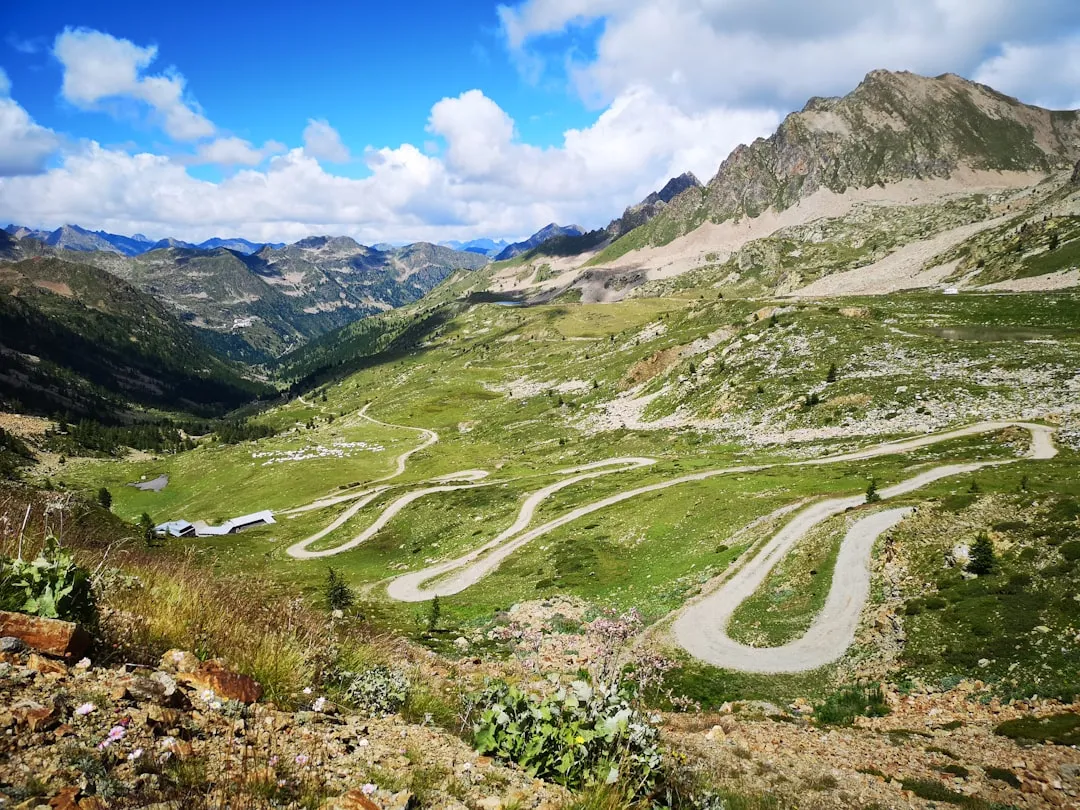
The Col de la Lombarde is a spectacular day walk located in the Maritime Alps, straddling the border between France and Italy. This route offers breathtaking panoramic views of the surrounding peaks, including the Mercantour National Park and the Italian Alps. It's a challenging yet rewarding hike, characterised by a significant elevation gain that leads to a high mountain pass, providing a true sense of alpine wilderness. The trail is well-defined for much of its length, making it accessible to experienced hikers seeking a substantial day out in a dramatic mountain landscape. The journey is a testament to the raw beauty of the high Alps, with alpine meadows, rocky outcrops, and sweeping vistas that change with every turn.
- Distance: 12.5 km one-way
- Duration: 5–6 hours
- Elevation Gain: 950 m
- Difficulty: Moderate to Challenging
- Season: June to September (snow-free conditions)
- Closest Town: Isola, France
- Trailhead Access: Via D97 road from Isola, parking available at the trailhead.
- Permits: Generally not required for day hiking, but always check local regulations.
Overview of the Col de la Lombarde Trail
The Col de la Lombarde trail is a classic alpine day hike that ascends from the French side of the border, near the ski resort of Isola 2000, to a prominent mountain pass. The hike is renowned for its consistent and substantial elevation gain, which rewards hikers with increasingly expansive views as they climb. The path winds through a variety of alpine environments, starting in lower mountain pastures and gradually transitioning to more rugged, rocky terrain as it approaches the pass. The summit of the Col de la Lombarde itself sits at a significant altitude, offering a commanding 360-degree panorama that encompasses the French Mercantour and the Italian landscape beyond.
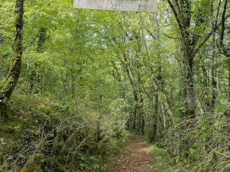
The trail's character is one of steady ascent. While not technically demanding in terms of scrambling or climbing, the sustained uphill effort requires good physical fitness. The path is generally well-maintained, though sections can be rocky and uneven, demanding careful footing. The flora changes with altitude, from vibrant alpine wildflowers in early summer to more sparse, hardy vegetation higher up. The air is crisp and clean, and the sense of remoteness is palpable, even though the trailhead is relatively accessible by road.
The Col de la Lombarde is a perfect destination for those who appreciate high-altitude scenery and the satisfaction of reaching a significant mountain pass. It offers a substantial physical challenge within a single day, making it an ideal objective for hikers looking to experience the grandeur of the Maritime Alps without the need for overnight accommodation. The descent offers a different perspective on the landscape, often quicker and allowing for reflection on the journey completed.
History and Significance of the Region
The region surrounding the Col de la Lombarde has a long history of human passage and interaction, primarily driven by its strategic location as a mountain pass. For centuries, this area served as a route for shepherds, traders, and travellers between the valleys of the French Mercantour and the Italian Piedmont. The presence of ancient tracks and shepherd huts in the vicinity hints at a long-standing human presence, adapted to the harsh alpine environment.
Historically, the Maritime Alps have been a frontier, and passes like the Col de la Lombarde played a role in regional connectivity and sometimes conflict. The area has seen periods of agricultural use, with shepherds guiding their flocks to high summer pastures, a practice that continues in some forms today. The development of modern infrastructure, such as the road leading to Isola 2000, has made these high-altitude areas more accessible, transforming them from remote wilderness into popular recreational destinations.
The establishment of national parks, such as the Mercantour National Park on the French side, has helped to preserve the natural beauty and ecological integrity of the region. These parks protect the unique alpine flora and fauna, ensuring that the landscape retains its wild character. The Col de la Lombarde, situated within this protected environment, benefits from these conservation efforts, allowing hikers to experience a relatively unspoiled mountain ecosystem.
Seasonal Considerations for the Col de la Lombarde
The Col de la Lombarde is a high-altitude trail, and its accessibility is heavily dependent on snow conditions. The primary hiking season typically runs from June to September. During these months, the snow generally melts from the higher elevations, revealing the trail and allowing for safe passage.
Spring (May to early June): Snow can persist at higher elevations well into June, especially in shaded areas and on north-facing slopes. Early season hikers should be prepared for potential snow crossings and may need to consult local sources for current conditions. The landscape begins to awaken, with early wildflowers appearing in the lower sections.
Summer (July to August): This is the peak season for hiking the Col de la Lombarde. The weather is generally more stable, and the days are long, providing ample time for the hike. Alpine meadows are typically in full bloom, offering a vibrant display of colours. However, summer can also bring thunderstorms, particularly in the afternoons. Hikers should always check the weather forecast and start their hike early to avoid potential storms.
Autumn (September to October): September often offers excellent hiking conditions with crisp air and fewer crowds. The autumn colours can be spectacular, with the alpine vegetation turning shades of gold and red. However, as October progresses, the risk of early snowfall increases, and temperatures drop significantly. By late October, the trail may become impassable due to snow.
Winter (November to April): The Col de la Lombarde is completely inaccessible and dangerous during winter due to heavy snowfall and avalanche risk. The area is covered in deep snow, and the trail is obliterated. This period is suitable only for experienced winter mountaineers with appropriate equipment and knowledge.
Recommended Itinerary
Col de la Lombarde Day Hike Itinerary
Early Morning: Departure from Isola
- Depart from Isola or nearby accommodation.
- Drive via the D97 road towards Isola 2000.
- Continue on the D97, which becomes a narrower, winding mountain road leading towards the Col de la Lombarde trailhead.
- The drive itself offers scenic views of the alpine landscape.
- Ensure you have sufficient fuel and supplies before starting the ascent.
Morning: Trailhead and Initial Ascent
- Arrive at the designated trailhead parking area near the Col de la Lombarde.
- GPS coordinates: 44.2436, 6.9278.
- Begin the hike. The initial section involves a steady climb through alpine pastures and open terrain.
- The path is generally well-marked, but always carry a map and compass or GPS device.
- Observe the changing vegetation and the first expansive views opening up.
- Distance covered: Approximately 3-4 km.
- Elevation gain: Approximately 300-400 m.
Midday: Ascending Towards the Pass
- Continue the ascent. The terrain may become rockier and steeper in sections.
- The trail may involve traversing scree slopes or rocky outcrops, requiring careful footing.
- Take breaks to admire the panoramic views unfolding behind you and to the sides.
- You will likely encounter other hikers, especially during peak season.
- Distance covered: Approximately 4-5 km.
- Elevation gain: Approximately 400-500 m.
Afternoon: Reaching the Col de la Lombarde and Descent
- Reach the summit of the Col de la Lombarde (altitude approximately 2,350 metres).
- Spend time at the pass, enjoying the 360-degree views of the surrounding mountains, including the Mercantour National Park and the Italian Alps.
- Take photographs and have a well-deserved lunch break.
- Begin the descent back towards the trailhead. The descent can be quicker but requires attention to avoid slips and falls on loose terrain.
- Distance covered: Approximately 4-5 km (descent).
- Elevation loss: Approximately 950 m.
Late Afternoon: Return to Trailhead
- Arrive back at the trailhead parking area.
- Total hiking time: 5–6 hours, excluding extended breaks.
- Drive back to Isola or your accommodation.
- Consider a celebratory meal or drink in Isola to mark the completion of your hike.
Planning and Bookings
Book Your Trip
Everything you need to plan your journey
Accommodation
Find places to stay near Isola
Flights
Search flights to Isola
Essential Preparation
The Col de la Lombarde is a day hike, meaning no overnight accommodation bookings are required. However, thorough preparation is crucial due to the significant elevation gain and alpine environment. The nearest significant town with amenities is Isola, which serves as a good base for accessing the trailhead. Ensure your vehicle is in good condition for mountain driving, as the road to the trailhead can be narrow and winding. Check the weather forecast meticulously in the days leading up to your hike, as alpine weather can change rapidly. Pack accordingly for variable conditions, including sun, wind, and potential rain or even snow at higher altitudes. Inform someone of your hiking plans, including your intended route and expected return time.
Trail Accommodation
This is a day hike requiring no overnight accommodation. The trail starts and finishes at the same trailhead, allowing for a return to Isola or other nearby accommodations each evening.
Required Gear
- Sturdy hiking boots: Waterproof and with good ankle support are essential for navigating rocky and uneven terrain.
- Waterproof and windproof jacket: Essential for protection against sudden weather changes and high-altitude winds.
- Waterproof overtrousers: Recommended for protection against rain and wind.
- Warm layers: Including a fleece or insulated jacket, and a hat and gloves, as temperatures can be significantly cooler at the pass.
- Sun protection: High SPF sunscreen, sunglasses, and a wide-brimmed hat are vital due to the intense sun at altitude.
- Navigation tools: A detailed map of the area, a compass, and a GPS device or smartphone with offline maps are highly recommended.
- First-aid kit: Including blister treatment, pain relievers, antiseptic wipes, and any personal medications.
- Head torch: With spare batteries, in case of unexpected delays or an early start/late finish.
- Backpack: A comfortable daypack (20-30 litres) to carry all your essentials.
What to Bring
- Sufficient water: Carry at least 2-3 litres of water per person. Water sources may be available but should be treated.
- Water treatment: A water filter or purification tablets are recommended if you plan to refill from natural sources.
- Food: High-energy snacks and a packed lunch are essential. Consider items like energy bars, nuts, dried fruit, sandwiches, and fruit.
- Toiletries: Biodegradable toilet paper, hand sanitiser, and any personal hygiene items.
- Mobile phone: Fully charged, though reception may be intermittent at higher elevations. Consider a power bank.
- Walking poles: Highly recommended for assisting with the steep ascents and descents, reducing strain on knees.
- Camera: To capture the stunning panoramic views.
- Small amount of cash: For any unexpected needs or local purchases.
Permits and Access
For day hiking on the Col de la Lombarde, specific permits are generally not required. The trail is part of the natural landscape and accessible to the public. However, it is always advisable to check with local authorities or the nearest tourist information office in Isola for any updated regulations or temporary restrictions that may be in place, especially concerning access roads or specific areas within the Mercantour National Park, which borders the region.
Trailhead Access:
- The most common access point is via the D97 road from Isola.
- The road is paved but can be narrow and winding, typical of mountain routes.
- Parking is available at the trailhead near the Col de la Lombarde. During peak season, parking areas can become busy, so arriving early is recommended.
- The nearest major airport is Nice Côte d'Azur Airport (NCE). From Nice, you would typically rent a car and drive approximately 1.5 to 2 hours to Isola.
- Public transport options to Isola are limited but may be available, particularly during the ski season. From Isola, local transport or a taxi might be needed to reach the trailhead if you do not have a private vehicle.
Road Conditions:
- The D97 road is generally well-maintained but can be subject to closures during winter months due to snow.
- Always check road conditions before travelling, especially outside of the main summer season.
Other Activities in the Area
The region around Isola and the Col de la Lombarde offers a variety of activities for outdoor enthusiasts:
- Skiing and Snowboarding: Isola 2000 is a popular ski resort, offering extensive slopes during the winter months.
- Mountain Biking: Numerous trails exist in the surrounding valleys and mountains, catering to various skill levels.
- Rock Climbing: The Mercantour National Park and surrounding areas offer opportunities for rock climbing and mountaineering.
- Exploring Isola Village: The historic village of Isola offers charming streets, traditional architecture, and local amenities.
- Scenic Drives: The mountain roads in the region provide spectacular views and are enjoyable for driving.
- Other Hiking Trails: Numerous other hiking routes of varying difficulty are available in the Mercantour National Park, offering diverse landscapes and experiences.
Safety and Conditions
Weather: Alpine weather is notoriously unpredictable. Be prepared for rapid changes, including sudden drops in temperature, strong winds, fog, and thunderstorms, especially in the afternoon. Always check the mountain forecast before setting out and be prepared to turn back if conditions deteriorate.
Altitude: The Col de la Lombarde is at a significant altitude (approx. 2,350 m). While most people do not experience severe altitude sickness on day hikes, be aware of symptoms such as headache, nausea, and dizziness. Ascend gradually and stay hydrated.
Terrain: The trail can be rocky, uneven, and steep. Good quality hiking boots with ankle support are essential. Be mindful of loose scree and potential slippery sections, especially after rain or if snow is present.
Navigation: While the main trail is generally well-marked, it is crucial to carry a map, compass, and/or GPS device. Do not rely solely on mobile phone reception, which can be unreliable in mountainous areas.
Water: Carry sufficient water for the entire hike. Natural water sources should be treated before consumption.
Wildlife: Be aware of local wildlife. While encounters are rare, it's important to maintain a safe distance and not feed any animals.
Emergency: In case of emergency, call the local mountain rescue number. It is advisable to have a fully charged mobile phone and consider carrying a personal locator beacon (PLB) for remote areas.
Physical Fitness: This hike involves a significant elevation gain of 950 metres over a relatively short distance, making it a strenuous day hike. Ensure you have a good level of cardiovascular fitness and leg strength.
Side Trips and Points of Interest
While the Col de la Lombarde itself is the primary objective, the journey offers several points of interest:
Alpine Meadows and Flora: Depending on the season, the lower and mid-sections of the trail pass through vibrant alpine meadows. In early to mid-summer, these areas are often carpeted with a diverse array of wildflowers, offering excellent photographic opportunities and a chance to observe alpine plant life.
Panoramic Viewpoints: Numerous points along the ascent offer increasingly spectacular views. Take time to pause and appreciate the unfolding vistas of the surrounding peaks, valleys, and the distant plains. These viewpoints are ideal for short breaks and enjoying the scale of the landscape.
Rocky Outcrops and Ridges: As the trail gains altitude, it traverses rocky terrain and sometimes follows narrow ridges. These sections provide a more rugged alpine experience and offer dramatic geological formations. Always exercise caution when navigating these areas.
The Border Itself: The Col de la Lombarde sits on the border between France and Italy. While not always clearly marked, you are technically crossing between two countries as you reach the pass, adding a unique geographical element to the hike.
Mercantour National Park Views: The trail offers excellent views into the heart of the Mercantour National Park on the French side, a vast protected area known for its rugged beauty and diverse wildlife.
Leave No Trace
The Col de la Lombarde trail traverses a sensitive alpine environment. Adhering to Leave No Trace principles is essential to preserve its natural beauty and ecological integrity for future visitors.
- Plan Ahead and Prepare: Understand the trail conditions, weather forecast, and your own capabilities. Pack appropriately for the conditions.
- Travel and Camp on Durable Surfaces: Stick to the marked trail. Avoid cutting switchbacks or walking on fragile vegetation, which can take years to recover.
- Dispose of Waste Properly: Pack out everything you pack in, including all food scraps, wrappers, and any other litter. Use designated toilet facilities where available, or dig catholes at least 70 metres away from water sources, trails, and campsites if necessary.
- Leave What You Find: Do not remove or disturb natural objects such as rocks, plants, or flowers.
- Minimise Campfire Impacts: Campfires are generally not permitted on day hikes and are discouraged in alpine environments. If permitted and necessary, use established fire rings and ensure fires are completely extinguished.
- Respect Wildlife: Observe wildlife from a distance. Never feed animals, as it can disrupt their natural behaviours and diets.
- Be Considerate of Other Visitors: Keep noise levels down and yield to other hikers on the trail.
By following these principles, you help ensure that the Col de la Lombarde remains a pristine and enjoyable destination.