Col de Coux Traverse
The Col de Coux Traverse is a captivating multi-day walk nestled in the heart of the Swiss Alps, offering a quintessential alpine experience. This route winds through dramatic mountain landscapes, traversing high passes, verdant alpine meadows, and charming mountain villages. It's a journey that rewards hikers with breathtaking vistas, a sense of accomplishment, and a deep connection with the natural beauty of the region. The traverse is renowned for its accessibility from major transport hubs while still providing a genuine wilderness feel, making it an ideal choice for those seeking a challenging yet manageable alpine adventure.
- Distance: 25.0 km
- Duration: 2-3 days
- Season: June to September (snow-free)
- Difficulty: Moderate
- Closest City: Monthey, Switzerland
- Trailhead Access: Nearest airport: Geneva (GVA). Take a train to Monthey, then bus 61 to Morgins. Road access via Route du Valais. Parking available in Morgins.
- No permits required for hiking.
Overview
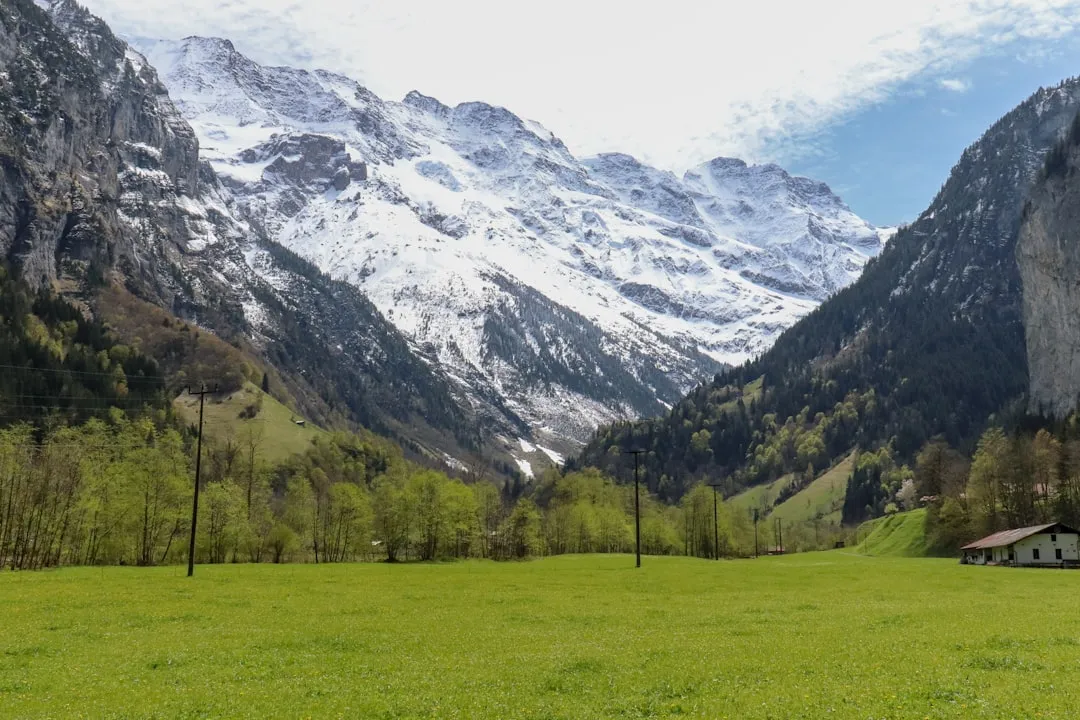
The Col de Coux Traverse is a moderately challenging route that typically spans two to three days, depending on the hiker's pace and preference for extended exploration. The trail begins in the picturesque village of Morgins, a well-established tourist destination in the Valais canton of Switzerland. From Morgins, the path ascends steadily, gradually revealing the majestic scale of the surrounding peaks. The initial stages often lead through dense pine forests, their scent filling the crisp mountain air, before opening up into expansive alpine pastures dotted with wildflowers during the summer months.
A significant feature of the traverse is the Col de Coux itself, a mountain pass that serves as a natural boundary and a high point offering panoramic views. The ascent to the pass is demanding, requiring a good level of fitness, but the reward is immense. From the summit, hikers are treated to sweeping vistas of the French Alps to one side and the Swiss Alps to the other, a truly awe-inspiring spectacle. The descent from the pass leads into new valleys, often featuring crystal-clear mountain lakes and traditional alpine chalets that offer a glimpse into the local way of life.
The trail is well-marked, a characteristic of Swiss hiking paths, ensuring that navigation is generally straightforward. However, the terrain can be rugged in places, with rocky sections and steep gradients that necessitate sturdy footwear and careful footing. The duration of the hike allows for a comfortable pace, with opportunities to pause, take photographs, and simply soak in the magnificent scenery. The journey concludes in a different valley or village, providing a sense of progression and discovery. The Col de Coux Traverse is an excellent introduction to multi-day hiking in the Alps, balancing physical exertion with unparalleled natural beauty and cultural immersion.
History and Cultural Context
The region surrounding the Col de Coux has a rich history intertwined with transhumance, trade, and the strategic importance of mountain passes. For centuries, these valleys have been traversed by shepherds moving their livestock between summer pastures (alpages) and winter quarters. This practice, known as transhumance, has shaped the cultural landscape, leaving behind traditional farming methods and architectural styles that are still visible today.
Mountain passes like the Col de Coux have historically served as vital links between communities, facilitating trade and cultural exchange between Switzerland and France. While not a major historical trade route in the same vein as some of the larger Alpine passes, it would have been used by local communities for centuries, connecting villages and enabling the movement of goods and people. The presence of old stone structures or remnants of ancient paths can sometimes be found, hinting at the historical significance of these routes.
The development of modern tourism in the Alps, particularly from the late 19th and early 20th centuries onwards, transformed these traditional routes into hiking trails. Local authorities and hiking associations began to mark and maintain paths, making them accessible to a wider audience. The Col de Coux Traverse, while perhaps not as historically documented as some of the more famous Alpine routes, benefits from this legacy of path maintenance and a long-standing appreciation for the mountain environment. Today, the traverse represents a blend of natural heritage and the enduring human connection to the Alpine landscape, offering a journey through a region that has been shaped by both nature and human endeavour over millennia.
Seasonal Highlights and Weather Reality
The Col de Coux Traverse is best enjoyed during the summer months, typically from June to September. During this period, the snow has largely receded from the higher elevations, making the trails accessible and safe for hiking. The weather in the Alps can be highly variable, even during the summer. Hikers should be prepared for a range of conditions, from warm sunshine to sudden thunderstorms and cooler temperatures at higher altitudes.
June: Early June can still see lingering snow at higher elevations, particularly on north-facing slopes. Wildflowers begin to bloom, and the landscape starts to turn green. The days are long, offering ample time for hiking. However, some higher passes might still be impassable or require snow gear.
July and August: These are the peak months for hiking. The weather is generally warmer, and the alpine meadows are in full bloom, creating a spectacular display of colour. This is also the busiest time for hikers. Thunderstorms are more common in the afternoons, so starting hikes early in the morning is advisable.
September: September offers a beautiful autumn palette with changing colours in the forests. The crowds thin out, and the air is often crisp and clear. However, the temperatures begin to drop, and there is an increased chance of early snowfall, especially towards the end of the month. The days are shorter, requiring careful planning of hiking times.
Weather Considerations: Regardless of the season, mountain weather can change rapidly. Hikers must always be prepared for rain, wind, and a significant drop in temperature, even on a sunny day. Hypothermia is a risk at higher altitudes. It is crucial to check the weather forecast before setting out and to carry appropriate clothing and safety equipment.
Recommended Itinerary
2-Day Col de Coux Traverse Itinerary
Day 1: Morgins to Chalet du Col de Coux (or nearby refuge)
- Distance: Approximately 12.0 km
- Elevation gain: Approximately 900 m
- Time: 4–5 hours
- Start in Morgins (1,350 m)
- Ascend through forests and alpine pastures
- Pass through areas with traditional alpages (summer pastures)
- Reach the Col de Coux (approx. 1,850 m)
- Descend slightly to a refuge or mountain hut near the pass for overnight stay
- Enjoy panoramic views of the surrounding Alps
- This day focuses on the ascent to the high point of the traverse
Day 2: Chalet du Col de Coux to Châtel (or other valley destination)
- Distance: Approximately 13.0 km
- Elevation loss: Approximately 700 m
- Time: 3–4 hours
- Depart from the refuge/hut near Col de Coux
- Continue descent through alpine terrain and forests
- The route may pass through different valleys or hamlets
- Arrive in the destination village, such as Châtel, offering amenities and transport links
- This day offers a different perspective of the Alpine landscape on the descent
3-Day Col de Coux Traverse Itinerary (with more leisure)
Day 1: Morgins to a mid-route mountain hut/alpage
- Distance: Approximately 8.0 km
- Elevation gain: Approximately 500 m
- Time: 3–4 hours
- A more relaxed start, allowing time to explore Morgins
- Ascend to a charming mountain hut or alpage situated at a lower elevation than the pass
- Enjoy the scenery and local hospitality
Day 2: Mid-route hut to Chalet du Col de Coux
- Distance: Approximately 7.0 km
- Elevation gain: Approximately 400 m
- Time: 2–3 hours
- Continue the ascent towards the Col de Coux
- Shorter hiking day allows for more time at the pass or exploring side areas
- Overnight at the refuge/hut near the Col de Coux
Day 3: Chalet du Col de Coux to Châtel
- Distance: Approximately 13.0 km
- Elevation loss: Approximately 700 m
- Time: 3–4 hours
- Descend from the pass to the final destination village
- This itinerary offers a more relaxed pace and deeper immersion in the Alpine environment
Important Notes:
- Accommodation in mountain huts or refuges must be booked in advance, especially during peak season.
- The exact route and overnight locations can vary based on available accommodation and personal preference.
- Always check trail conditions and weather forecasts before and during your hike.
- Carry sufficient water and snacks, as services can be limited between villages and huts.
Planning and Bookings
Book Your Trip
Everything you need to plan your journey
Accommodation
Find places to stay near Monthey
Flights
Search flights to Monthey
Essential Preparation
The Col de Coux Traverse is a multi-day hike that requires careful planning to ensure a safe and enjoyable experience. The closest major city with comprehensive services is Monthey, which serves as a convenient gateway to the region. From Monthey, public transport, primarily buses, connects hikers to the trailhead village of Morgins. It is advisable to spend at least one night in Monthey or Morgins before starting the hike to acclimatise, gather last-minute supplies, and confirm transport arrangements.
Fitness: The traverse involves significant elevation gain and loss, with moderate to challenging sections. Hikers should be in good physical condition, capable of walking for several hours each day with a backpack. Training that includes hill walking and carrying a weighted pack is highly recommended. The 1,500 metres of elevation gain over the course of the hike requires a reasonable level of cardiovascular fitness and leg strength.
Logistics: Plan your transport to and from the trailheads. Geneva Airport (GVA) is the nearest international airport. From Geneva, take a train to Monthey (approximately 1 hour 30 minutes). From Monthey, a bus (line 61) will take you to Morgins (approximately 30 minutes). Ensure you have a return plan from your finishing point, which may involve similar bus and train connections.
Base Town: Morgins is a charming village that serves as an excellent starting point. It offers hotels, guesthouses, restaurants, and basic amenities. For more extensive services, Monthey is the larger town with a wider range of accommodation, supermarkets, outdoor gear shops, and a more comprehensive public transport network.
Trail Accommodation
Accommodation along the Col de Coux Traverse typically consists of mountain huts (refuges) and guesthouses or hotels in the villages. Booking in advance is highly recommended, especially during the peak summer season (July and August).
Mountain Huts (Refuges):
- Booking Requirements: Essential to book in advance, often several weeks or months ahead for popular huts. Contact details and booking procedures are usually available online via the hut's website or through national alpine club directories.
- Facilities Provided: Dormitory-style sleeping quarters with mattresses and blankets. Communal dining areas. Often have basic toilet facilities (sometimes composting) and access to water from a nearby spring or stream. Some may offer simple meals (breakfast, dinner) for an additional charge.
- What's NOT Provided: Sleeping bags (a liner is usually mandatory), toiletries, towels, cooking equipment (unless specified), electricity for charging devices (rare), and often no hot water for showers.
- Seasonal Availability: Generally open from June/July to September/October, depending on snow conditions and the specific hut.
- Costs: Varies significantly, but expect approximately CHF 50-80 per person per night for a dorm bed, with meals costing extra.
Village Accommodation:
- Booking Requirements: Recommended to book in advance, especially in smaller villages.
- Facilities Provided: Hotels, guesthouses, and apartments offer private rooms or self-catering options with standard amenities like beds, bathrooms, and often Wi-Fi. Restaurants are usually available.
- What's NOT Provided: Specific to the establishment, but generally self-sufficient.
- Seasonal Availability: Typically year-round, but services might be reduced in the shoulder seasons.
- Costs: CHF 80-150+ per night for a double room, depending on the level of comfort and location.
Note: This is a day hike requiring no overnight accommodation.
Required Gear
- Sturdy Hiking Boots: Waterproof, with good ankle support and a well-worn sole. Essential for varied terrain.
- Backpack: A 30-45 litre pack is suitable for a 2-3 day hike, with a rain cover.
- Waterproof Jacket: Breathable and waterproof (e.g., Gore-Tex) with taped seams.
- Waterproof Overtrousers: Essential for protection against rain and wind.
- Warm Layers: Fleece jacket or insulated jacket, thermal base layers (merino wool or synthetic).
- Hat and Gloves: Even in summer, temperatures can drop significantly at altitude.
- Navigation Tools: Map of the area, compass, and a GPS device or smartphone with offline maps.
- Head Torch: With spare batteries, for use in huts or if hiking in low light.
- First-Aid Kit: Including blister treatment, pain relievers, antiseptic wipes, bandages, and any personal medications.
- Sun Protection: High SPF sunscreen, sunglasses, and a wide-brimmed hat.
What to Bring
- Food: High-energy snacks (nuts, dried fruit, energy bars), lunches for each day, and any preferred breakfast items if not planning to eat at huts.
- Water Bottles or Hydration Reservoir: Capacity for at least 2 litres per person.
- Water Purification: Filter or purification tablets as a backup, though stream water is generally potable at higher altitudes.
- Toiletries: Biodegradable soap, toothbrush, toothpaste, small towel, toilet paper, hand sanitiser.
- Personal Items: Camera, power bank for electronics, book or journal, insect repellent (especially for lower altitudes and evenings).
- Cash: For use in mountain huts or small villages where card payments may not be accepted.
- Trekking Poles: Highly recommended for stability on ascents and descents, and to reduce strain on knees.
- Sleeping Bag Liner: Often mandatory in mountain huts for hygiene.
Permits
For the Col de Coux Traverse, no specific hiking permits are required. The trails are part of the public domain and are generally accessible to all. However, it is crucial to note that accommodation in mountain huts or refuges along the route does require advance booking. These bookings are managed by the individual hut operators or relevant alpine clubs and are essential to secure a place to stay, particularly during the busy summer months.
Accommodation Booking:
- Advance Reservations: It is strongly advised to book your accommodation in mountain huts well in advance, ideally several months before your planned hike, especially if travelling during July or August.
- Contact Information: Hut contact details and booking procedures can typically be found on the websites of the Swiss Alpine Club (SAC) or French Alpine Club (CAF), or through local tourism offices.
- Flexibility: If your itinerary involves specific huts, have backup options in mind as popular huts can fill up quickly.
National Park Regulations: While no specific hiking permits are needed, always be aware of and adhere to any local regulations regarding camping, fires, and waste disposal in the areas you traverse. Respecting the natural environment is paramount.
Other Activities in the Area
The region surrounding the Col de Coux Traverse offers a wealth of activities for those looking to extend their stay or explore beyond the hiking trails:
- Mountain Biking: The valleys and lower slopes are crisscrossed with numerous mountain biking trails, catering to various skill levels.
- Via Ferrata: Several challenging via ferrata routes are accessible in the wider Chablais Alps region, offering a thrilling way to experience the vertical landscape.
- Paragliding: The thermal conditions in the Alps are often ideal for paragliding, with opportunities for tandem flights offering spectacular aerial views of the traverse route and surrounding peaks.
- Lake Geneva (Lac Léman): A short drive or train ride away, Lake Geneva offers opportunities for swimming, boating, and visiting charming lakeside towns like Montreux and Lausanne.
- Thermal Baths: The Val d'Illiez region, not far from Morgins, is known for its thermal spas, providing a relaxing way to unwind after a strenuous hike.
- Cultural Exploration: Visit local cheese dairies (alpages) to learn about traditional Alpine cheese-making and sample local produce. Explore the historic towns and villages in the surrounding valleys.
- Rock Climbing: Numerous climbing areas are available for those with the necessary skills and equipment.
Safety and Conditions
Weather: Mountain weather is unpredictable. Always check the forecast before you depart and be prepared for rapid changes. Afternoon thunderstorms are common in summer. Temperatures can drop significantly at higher altitudes, even on sunny days.
Trail Conditions: Trails are generally well-maintained and marked, but can be steep, rocky, and exposed in places. Snow can linger on higher passes well into June or even early July, and early snowfalls can occur in September. Always wear appropriate footwear and use trekking poles for stability.
Navigation: While trails are marked, it is essential to carry a map and compass and know how to use them. A GPS device or smartphone with offline maps is also highly recommended. Do not rely solely on mobile phone signal, as it can be unreliable in mountainous terrain.
Water: Carry sufficient water for your daily needs. While streams are often potable at higher altitudes, it is advisable to use a water filter or purification tablets as a precaution, especially at lower elevations or near livestock.
Altitude: The Col de Coux Traverse reaches an altitude of approximately 1,850 metres. While not extremely high, some individuals may experience mild altitude sickness. Ascend gradually and stay hydrated.
Emergency: In case of emergency, contact local mountain rescue services. The general emergency number in Switzerland is 144. For mountain rescue, specific numbers may apply depending on the region, but 144 is a good starting point. Ensure you have a fully charged mobile phone and consider carrying a personal locator beacon (PLB) for remote areas.
Wildlife: Be aware of local wildlife. While encounters are rare, respect their space and do not feed any animals. Livestock, such as cows and sheep, are common in alpine pastures; give them a wide berth.
Insurance: Ensure you have adequate travel insurance that covers hiking and potential mountain rescue.
Side Trips and Points of Interest
Alpine Pastures (Alpages): Throughout the traverse, you will likely pass through traditional alpine pastures where cows graze during the summer months. These areas are often dotted with charming wooden chalets and offer opportunities to witness traditional farming practices. Some alpages may offer fresh cheese for sale.
Panoramic Viewpoints: The Col de Coux itself is a significant viewpoint, offering expansive vistas. Along the route, numerous natural clearings and ridges provide excellent spots for photography and to simply admire the grandeur of the Alps. Keep an eye out for markers indicating specific viewpoints.
Local Villages: Morgins and Châtel (or other potential finishing villages) are points of interest in themselves. They offer a glimpse into local Swiss and French Alpine culture, with traditional architecture, local cuisine, and opportunities to interact with residents.
Flora and Fauna: The alpine meadows are rich in wildflowers during the summer months, providing a vibrant display of colour. Birdlife is also abundant, and with luck, you might spot chamois or ibex in the higher, more remote areas.
Geological Features: Observe the dramatic geological formations, including the U-shaped valleys carved by glaciers and the rugged rock faces that characterise the Alpine landscape.
Leave No Trace
The Col de Coux Traverse passes through pristine natural environments, and it is essential to practice Leave No Trace principles to preserve their beauty and ecological integrity for future generations.
- Plan Ahead and Prepare: Research the trail, understand the terrain, and be aware of weather conditions. Book accommodation in advance.
- Travel and Camp on Durable Surfaces: Stick to marked trails to avoid damaging fragile vegetation. If camping is permitted in designated areas (though generally not on this route), use established sites.
- Dispose of Waste Properly: Pack out everything you pack in, including all food scraps, wrappers, and any other litter. Use designated toilet facilities in huts and villages. If no facilities are available, dig a cathole at least 60 metres away from water sources, trails, and campsites.
- Leave What You Find: Do not remove any natural objects, such as rocks, plants, or flowers. Take only photographs and memories.
- Minimise Campfire Impacts: Campfires are generally not permitted on this route. If allowed in specific areas, use existing fire rings and ensure fires are completely extinguished.
- Respect Wildlife: Observe wildlife from a distance and never feed them. Feeding animals can disrupt their natural behaviours and diets.
- Be Considerate of Other Visitors: Keep noise levels down, yield to other hikers, and maintain a respectful attitude towards the local culture and environment.
By adhering to these principles, you help ensure that the Col de Coux Traverse remains a beautiful and wild place for everyone to enjoy.