Col de la Croix du Bonhomme - A High Alpine Traverse
The Col de la Croix du Bonhomme is a challenging multi-day walk traversing the French Alps, offering a spectacular high-altitude experience. This route is not a single, defined track like some famous long-distance paths, but rather a collection of interconnected trails and mountain passes that form a demanding circuit. It winds through dramatic alpine landscapes, past glacial lakes, over rugged mountain passes, and through charming mountain villages. The trail is renowned for its breathtaking panoramic views, diverse flora and fauna, and the sense of accomplishment that comes from navigating such a wild and beautiful environment.
- Distance: Approximately 85.0 km
- Duration: 5–7 days
- Elevation Gain: Approximately 5,500 m
- Difficulty: Challenging
- Best Season: June to September (summer months)
- Closest Major City: Chamonix
- Trailhead Access: Les Contamines-Montjoie
- Permits: Not required for general access
Overview
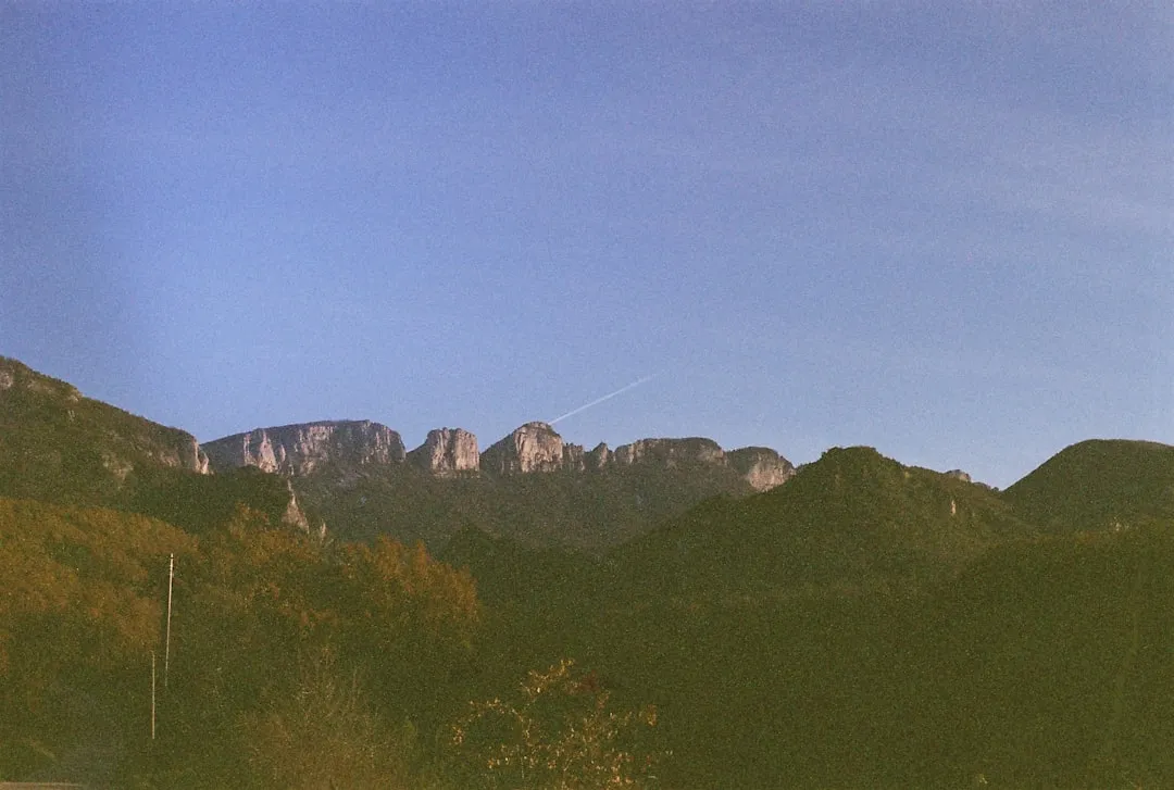
The Col de la Croix du Bonhomme walk is an immersion into the heart of the French Alps, a region celebrated for its rugged beauty and challenging terrain. This route is best described as a high-level traverse, connecting several significant mountain passes and valleys, with the Col de la Croix du Bonhomme itself being a prominent landmark. The journey typically begins in the picturesque valley town of Les Contamines-Montjoie, a gateway to the Vanoise National Park and the Mont Blanc massif. From here, the trail ascends steadily, gradually revealing the immense scale of the surrounding peaks and glaciers.
The path is characterised by its varied terrain. You will encounter well-maintained GR (Grande Randonnée) paths, rocky scree slopes, high alpine meadows bursting with wildflowers in summer, and sections that require careful navigation. The elevation gain is substantial, with numerous ascents and descents that test endurance and fitness. The reward for this effort is unparalleled. Expect to be surrounded by a panorama of snow-capped peaks, including views towards the Mont Blanc range on clear days. The air is crisp and clean, and the silence of the high mountains is broken only by the sound of wind, distant cowbells, or the call of alpine birds.
This walk is not for the faint-hearted. It demands a good level of physical fitness, experience with mountain terrain, and the ability to navigate. However, for those who are prepared, the Col de la Croix du Bonhomme offers an unforgettable adventure, a chance to disconnect from the everyday and reconnect with the raw power and beauty of the natural world. The sense of solitude and achievement at the summit of a pass, with the vast alpine landscape stretching out before you, is profoundly rewarding.
History and Cultural Context
The region surrounding the Col de la Croix du Bonhomme has a rich history deeply intertwined with pastoralism, trade, and pilgrimage. For centuries, these high mountain pastures have been used for summer grazing by livestock, a tradition that continues to this day. The presence of shepherds and their flocks has shaped the landscape and the local culture, with many of the mountain huts (refuges) along the route having origins as simple shelters for these pastoralists.
The Col de la Croix du Bonhomme itself has historically been an important crossing point. Its name, translating to "Pass of the Good Man," is believed to derive from a chapel or shrine dedicated to a benevolent figure, possibly a saint or a local benefactor, that once stood near the pass. Such landmarks often served as points of reference and spiritual solace for travellers navigating the challenging alpine terrain. The pass would have been used by traders, pilgrims, and local communities moving between valleys and regions, connecting the Savoie region with Italy.
The development of modern hiking trails, including the GR routes that often form the backbone of this traverse, began in the 20th century. These routes were established to make the mountains more accessible for recreation and tourism, while also preserving the traditional paths and cultural heritage of the region. The Vanoise National Park, established in 1963, plays a crucial role in protecting the natural environment and its historical significance, ensuring that the wild beauty and cultural legacy of the Alps are maintained for future generations.
Seasonal Highlights and Weather Reality
The optimal season for walking the Col de la Croix du Bonhomme is during the summer months, from June to September. During this period, the snow has largely receded from the higher passes, and the weather is generally more stable, although alpine conditions can change rapidly at any time.
June: Early June can still see significant snow cover on the higher passes, particularly on north-facing slopes. Some mountain refuges may not yet be fully operational. Wildflowers begin to bloom in the lower valleys, but the higher alpine meadows are still awakening. Days are long, offering ample daylight for hiking.
July and August: These are the peak months for wildflowers, with alpine meadows transforming into vibrant carpets of colour. The weather is typically at its warmest and most stable, though thunderstorms are common in the afternoons. This is also the busiest period, with refuges requiring advance booking. The Col de la Croix du Bonhomme and surrounding passes offer spectacular, unobstructed views.
September: September offers a beautiful autumn palette in the lower valleys, with crisp, clear air and fewer crowds. The higher passes may experience early snowfalls, especially towards the end of the month. The light can be particularly beautiful for photography, and the cooler temperatures can make for more comfortable hiking. However, days are shorter, and the risk of unpredictable weather increases.
Weather: The Alps are notorious for their unpredictable weather. Even in summer, you can experience sunshine, rain, hail, and strong winds all within a single day. Temperatures can drop significantly at higher altitudes, especially at night. It is crucial to be prepared for all conditions, including cold and wet weather, regardless of the season.
Recommended Itinerary
5-Day Col de la Croix du Bonhomme Itinerary (Example)
Day 1: Les Contamines-Montjoie to Refuge de la Croix du Bonhomme
- Distance: Approximately 12 km
- Elevation Gain: Approximately 1,200 m
- Time: 5–6 hours
- Start in Les Contamines-Montjoie (1,164 m)
- Ascend through forests and alpine pastures towards the Col de la Croix du Bonhomme
- Pass by the charming hamlet of La Chapelle-Blanche
- The final ascent offers increasingly dramatic views of the surrounding peaks
- Arrive at the Refuge de la Croix du Bonhomme (2,443 m)
- Settle in and enjoy the panoramic sunset views
Day 2: Refuge de la Croix du Bonhomme to Refuge des Lacs Merlet
- Distance: Approximately 15 km
- Elevation Gain: Approximately 800 m
- Elevation Loss: Approximately 700 m
- Time: 6–7 hours
- Descend from the refuge towards the Col des Fours (2,976 m) - a more challenging pass
- Alternatively, follow a lower route towards the Col du Bonhomme
- Traverse high alpine terrain with stunning views of the Mont Blanc massif
- Descend towards the picturesque Lac des Lacs Merlet
- Arrive at Refuge des Lacs Merlet (approx. 2,200 m)
- Enjoy the serene setting by the lakes
Day 3: Refuge des Lacs Merlet to Refuge de la Femma
- Distance: Approximately 18 km
- Elevation Gain: Approximately 900 m
- Elevation Loss: Approximately 1,000 m
- Time: 7–8 hours
- Continue traversing high mountain terrain
- Pass through varied landscapes, including rocky sections and alpine meadows
- Potential for wildlife sightings (marmots, chamois)
- Descend into a new valley system
- Arrive at Refuge de la Femma (approx. 2,100 m)
- A day of significant elevation changes and expansive vistas
Day 4: Refuge de la Femma to Refuge du Plan de la Lai
- Distance: Approximately 16 km
- Elevation Gain: Approximately 700 m
- Elevation Loss: Approximately 600 m
- Time: 6–7 hours
- Follow trails through alpine pastures and potentially some forested sections
- The route may involve crossing smaller cols and ridges
- Enjoy views of different mountain ranges as you progress
- Arrive at Refuge du Plan de la Lai (approx. 1,800 m)
- A slightly less demanding day in terms of elevation, allowing for more relaxed enjoyment of the scenery
Day 5: Refuge du Plan de la Lai to Les Contamines-Montjoie
- Distance: Approximately 14 km
- Elevation Gain: Approximately 300 m
- Elevation Loss: Approximately 900 m
- Time: 4–5 hours
- Descend from the refuge back towards the valley floor
- The trail will lead you through forests and past streams
- Rejoin the valley path near Les Contamines-Montjoie
- Complete the circuit back in Les Contamines-Montjoie
- A pleasant final day of descent and reflection on the journey
Note: This is a sample itinerary. The exact route and daily distances can vary significantly based on chosen paths, refuges, and personal pace. Always consult detailed maps and guidebooks for precise route planning.
Planning and Bookings
Book Your Trip
Everything you need to plan your journey
Accommodation
Find places to stay near Chamonix
Flights
Search flights to Chamonix
Essential Preparation
The Col de la Croix du Bonhomme is a challenging trek that requires thorough preparation. Given its alpine nature, fitness is paramount. Aim to have a solid base level of cardiovascular fitness, with regular hiking experience that includes significant elevation gain and carrying a loaded backpack. Practice hiking on varied terrain, including rocky and uneven paths, to prepare your body for the demands of the trail.
Logistics are key. The nearest major city and transport hub is Chamonix. From Geneva Airport (GVA), you can take a bus or train to Chamonix. From Chamonix, a local bus service connects to Les Contamines-Montjoie, the primary trailhead for this route. If driving, the A40 motorway provides access to the region, with parking available in Les Contamines. It is advisable to arrive in Les Contamines at least one day before starting your trek to acclimatise, finalise gear, and confirm transport arrangements.
Booking accommodation in mountain refuges is essential, especially during the peak summer months (July and August). Many refuges are popular and can book up weeks or even months in advance. It is highly recommended to book all your accommodation before you depart. Consider purchasing detailed topographic maps of the area and a guidebook to assist with navigation and route planning.
Trail Accommodation
The Col de la Croix du Bonhomme route typically involves staying in mountain refuges (refuges de montagne) or, in some cases, simpler bivouac shelters or designated camping areas (where permitted and available). These refuges offer basic but comfortable accommodation, usually in dormitory-style rooms with bunk beds.
Refuge Facilities:
- Bunk beds with mattresses and pillows (sleeping bags or liners are mandatory)
- Common dining area
- Often a bar serving drinks and sometimes snacks
- Toilets (may be basic pit toilets or more modern facilities)
- Access to water (usually from a spring or stream; treatment is recommended)
- Some refuges offer half-board (dinner and breakfast), which is highly recommended for convenience and nutrition.
What's NOT Provided:
- Bed linen (you must bring your own sleeping bag or liner)
- Towels
- Cooking equipment (you cannot cook your own food in most refuges, unless specified)
- Electricity for charging devices (limited availability in some refuges, often at a cost)
- Wi-Fi or mobile phone signal (highly unreliable in mountain areas)
Booking Requirements:
- Advance booking is essential, especially for refuges during the summer season (June-September).
- Bookings can typically be made directly via the refuge's website or by phone.
- Many refuges offer half-board options (dinner and breakfast), which is the most common and recommended way to stay.
- Costs vary, but expect to pay approximately €40-€70 per night for half-board.
Seasonal Availability: Most refuges are open from mid-June to mid-September, depending on snow conditions and demand. Always check the specific opening dates for the refuges you plan to use.
Required Gear
- Sturdy hiking boots: Waterproof, with good ankle support and a well-worn sole for grip on rocky terrain.
- Waterproof and windproof jacket: Essential for protection against sudden alpine weather changes.
- Waterproof overtrousers: To keep your legs dry during rain.
- Warm layers: Fleece jacket or down vest, thermal base layers (merino wool or synthetic).
- Hat and gloves: Even in summer, temperatures can drop significantly at altitude.
- Backpack: 40-60 litre capacity, with a comfortable harness and hip belt. A rain cover is highly recommended.
- Sleeping bag or sleeping bag liner: Mandatory for use in refuges. A 3-season bag is generally sufficient for summer.
- Head torch: With spare batteries, for navigating in refuges or during early morning/late evening hikes.
- First-aid kit: Including blister treatment, pain relievers, antiseptic wipes, bandages, and any personal medications.
- Navigation tools: Detailed topographic maps (1:25,000 scale recommended), compass, and a GPS device or smartphone with offline mapping capabilities.
- Sun protection: High SPF sunscreen, sunglasses, and a wide-brimmed hat.
What to Bring
- Food: While refuges offer meals, it's wise to carry high-energy snacks (nuts, dried fruit, energy bars) for lunches and in-between meals.
- Water bottles or hydration reservoir: Capacity of at least 2 litres per person.
- Water purification tablets or filter: Recommended for treating water from streams, even if you plan to rely on refuge water.
- Toiletries: Biodegradable soap, toothbrush, toothpaste, small quick-drying towel, hand sanitiser.
- Personal items: Camera, power bank for electronics, book or journal, trekking poles (highly recommended for ascents and descents).
- Cash: Some refuges may not accept credit cards, and it's useful for small purchases or tips. Euros are the currency.
- Duct tape: Invaluable for quick repairs to gear.
- Small backpack or daypack: For shorter excursions from refuges or for carrying essentials during the day.
Permits
For general hiking and staying in the mountain refuges along the Col de la Croix du Bonhomme route, no specific permits are required in the same way as for some national parks or protected areas. However, it is crucial to understand that staying in mountain refuges necessitates advance booking and payment. These refuges are privately or communally managed, and their services are paid for.
Refuge Bookings:
- Advance Reservation: It is strongly advised to book your accommodation in each refuge well in advance, especially if you are travelling during the peak season (July and August). Many refuges have limited capacity and can fill up quickly.
- Booking Methods: Most refuges have websites where you can book online, or they can be contacted by telephone. It is best to book directly with each refuge you intend to stay at.
- Half-Board: The most common booking option is "demi-pension" (half-board), which includes dinner and breakfast. This is highly recommended for convenience and to ensure you have adequate nutrition for your days of hiking.
- Costs: Prices vary per refuge, but expect to pay approximately €40-€70 per person per night for half-board.
Vanoise National Park Regulations: While no specific hiking permit is needed, the Vanoise National Park has regulations in place to protect its environment. These typically include rules against:
- Wild camping (except in designated bivouac zones, which are rare and often require special permission)
- Lighting fires
- Disturbing wildlife
- Leaving litter
Always familiarise yourself with the specific regulations of the Vanoise National Park before your trip.
Trail Access: The trails themselves are generally open to the public. The route is often part of the GR (Grande Randonnée) network, which is maintained for public access.
Other Activities in the Area
The region around the Col de la Croix du Bonhomme offers a wealth of activities for those looking to extend their stay or explore beyond the main hiking route:
- Day Hikes: Numerous shorter day hikes branch off from the main route or can be accessed from Les Contamines-Montjoie. These offer opportunities to explore different valleys, reach smaller peaks, or visit scenic lakes.
- Climbing and Mountaineering: For experienced individuals, the surrounding peaks offer opportunities for rock climbing and more technical mountaineering. The proximity to the Mont Blanc massif means there are options for all skill levels, though these require specific expertise and equipment.
- Via Ferrata: Several via ferrata routes are available in the wider Savoie region, offering a thrilling way to experience cliff faces with the aid of steel cables, ladders, and bridges.
- Mountain Biking: Dedicated mountain biking trails exist in the valleys, providing a different perspective on the alpine landscape.
- Paragliding: The high mountain air and stunning vistas make this region popular for paragliding, with opportunities for tandem flights for beginners.
- Visiting Chamonix: A short bus or car ride away, Chamonix offers a vibrant town atmosphere with shops, restaurants, museums, and access to attractions like the Aiguille du Midi cable car for unparalleled views of Mont Blanc.
- Exploring Local Villages: Les Contamines-Montjoie itself is a charming village with traditional architecture, local crafts, and excellent regional cuisine. Other nearby villages also offer a glimpse into alpine life.
Safety and Conditions
Pre-Trip Checks:
- Weather Forecast: Always check the most up-to-date mountain weather forecast before and during your trek. Websites like Météo-France provide detailed alpine forecasts. Be prepared for rapid changes.
- Trail Conditions: Inquire at local tourist offices or refuges about current trail conditions, especially early or late in the season when snow may still be present on higher passes.
- Emergency Contacts: Save local emergency numbers (SAMU: 15, Gendarmerie: 17, Fire Brigade: 18, European emergency number: 112) on your phone.
Alpine Hazards:
- Altitude Sickness: While this route may not reach extreme altitudes, rapid ascents can still affect some individuals. Ascend gradually, stay hydrated, and be aware of symptoms like headache, nausea, and dizziness.
- Hypothermia: Even in summer, temperatures can drop significantly, especially at night or in bad weather. Always carry warm layers, waterproofs, and a hat and gloves.
- Falls: The terrain can be steep, rocky, and uneven. Wear sturdy hiking boots, use trekking poles for stability, and watch your footing carefully.
- Getting Lost: While many trails are well-marked, visibility can be reduced in fog or bad weather. Carry and know how to use a map and compass, and consider a GPS device.
- Wildlife: While generally shy, be aware of potential encounters with marmots, chamois, or ibex. Do not approach or feed wild animals.
Refuge Safety:
- Respect Rules: Adhere to the rules of each refuge regarding noise, cleanliness, and sleeping arrangements.
- Water: While water sources are generally good, it is always advisable to treat water from streams or springs using purification tablets or a filter, especially if you have a sensitive stomach.
- Fire: Open fires are strictly prohibited in the mountains and refuges.
Communication: Mobile phone signal is often non-existent in the mountains. Consider carrying a personal locator beacon (PLB) or satellite messenger for emergencies.
Travel Insurance: Ensure your travel insurance covers hiking at altitude and potential emergency evacuation.
Side Trips and Points of Interest
Col des Fours: A challenging but rewarding detour from the main route, often taken on Day 2. This pass offers even more expansive views and a true sense of high alpine wilderness. It requires good navigation skills and is best attempted in clear weather.
Lac des Lacs Merlet: A series of beautiful alpine lakes that provide a stunning setting for a night's stay or a midday break. The reflections of the surrounding peaks in the clear water are particularly picturesque.
The Vanoise National Park: The entire route traverses or borders the Vanoise National Park, France's first national park. It is a haven for wildlife, including ibex, chamois, marmots, and a rich diversity of alpine flora. Keep an eye out for these creatures and the vibrant wildflowers that carpet the meadows in summer.
Traditional Alpine Villages: The starting and ending point, Les Contamines-Montjoie, is a charming example of a traditional Savoyard village. Exploring its streets, architecture, and local culture adds another dimension to the trip.
Panoramic Viewpoints: Numerous points along the trail offer breathtaking panoramic views. The Col de la Croix du Bonhomme itself provides a spectacular vantage point, as do many of the higher sections of the route, offering vistas of the Mont Blanc massif and the surrounding French and Italian Alps.
Leave No Trace
The Col de la Croix du Bonhomme route traverses sensitive alpine environments, including the Vanoise National Park. Adhering to Leave No Trace principles is crucial to preserving this pristine landscape for future generations and for the enjoyment of all who walk here.
Plan Ahead and Prepare: Research your route, book accommodation in advance, and be aware of local regulations. Pack appropriately for all weather conditions to avoid unnecessary risks or reliance on local resources.
Travel and Camp on Durable Surfaces: Stick to marked trails to avoid damaging fragile alpine vegetation. If camping is permitted in designated areas, use established sites. In refuges, follow the designated sleeping areas.
Dispose of Waste Properly: Pack out everything you pack in, including all food scraps, wrappers, and any other litter. Use designated toilet facilities in refuges. If no facilities are available, dig a cathole at least 60 metres away from water sources, trails, and campsites.
Leave What You Find: Do not remove plants, rocks, or any natural or cultural artifacts. Take only photographs and memories.
Minimise Campfire Impacts: Campfires are generally prohibited in alpine environments and national parks. Use a lightweight stove for cooking.
Respect Wildlife: Observe wildlife from a distance. Never feed animals, as this can disrupt their natural behaviours and diets. Store food securely to prevent attracting animals.
Be Considerate of Other Visitors: Keep noise levels down, especially in refuges and natural areas. Yield to others on narrow trails. Respect the peace and solitude of the mountains.