
Coastal Path of Brittany (GR34) - The Sentier des Douaniers
The Coastal Path of Brittany, known officially as the GR34 (Grande Randonnée 34), is one of France's most iconic and physically diverse long-distance trekking routes. Stretching over 2,000 kilometres, it traces the entirety of the Breton coastline, from the mystical bay of Mont Saint-Michel in the north to the industrial yet scenic estuary of Saint-Nazaire in the south. Originally established in the 18th century as a patrol path for customs officers—the "Sentier des Douaniers"—to combat smuggling, the trail has been transformed into a world-class hiking experience that offers an unparalleled immersion into the maritime soul of Brittany. Walkers traverse a landscape of dramatic granite cliffs, hidden turquoise coves, expansive salt marshes, and historic port towns where the rhythm of life is still dictated by the tides of the Atlantic Ocean.
This is not merely a walk; it is a journey through the geological and cultural heart of a region that feels distinct from the rest of France. With a total elevation gain exceeding 20,000 metres, the path is deceptively challenging, constantly rising and falling as it hugs the jagged contours of the Armorican Massif. Whether you are attempting a full thru-hike over several months or exploring specific sections over a week, the GR34 provides a sensory feast of salty air, the scent of blooming gorse and heather, and the ever-present sound of crashing waves. It is a trail that demands endurance but rewards the traveller with some of the most spectacular coastal scenery in Europe, all while remaining accessible to those who appreciate the comforts of Breton hospitality and gastronomy at the end of a long day's trek.
- Distance: 2,000 km (approximate total length)
- Duration: 80 to 100 days for a full thru-hike; variable for sections
- Season: Best from April to October (Spring and Autumn for milder weather)
- Accommodation: Gîtes d'étape, campsites, hotels, and chambres d'hôtes
- Highest point: Various coastal cliffs reaching up to 100 metres above sea level
- Difficulty: Moderate (high cumulative elevation gain and technical coastal terrain)
- Direction: Can be walked in either direction, though North to South is traditional
Overview
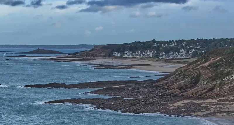
The Coastal Path of Brittany is a masterclass in coastal diversity. Unlike many mountain thru-hikes that offer a singular aesthetic, the GR34 evolves every few kilometres. In the north, the Emerald Coast (Côte d'Émeraude) presents walkers with deep green waters and elegant 19th-century villas. Further west, the Pink Granite Coast (Côte de Granit Rose) showcases surreal, wind-sculpted rock formations that glow with an ethereal copper hue at sunset. As the trail rounds the westernmost tip of France at the Pointe du Raz, the landscape becomes wilder and more elemental, facing the full brunt of the Atlantic gales. The southern coast offers a gentler, more Mediterranean atmosphere, with the Gulf of Morbihan providing sheltered waters and a labyrinth of islands.
The physical reality of the GR34 is one of constant motion. While the maximum altitude rarely exceeds 100 metres, the "sawtooth" profile of the trail—dropping down to sea level at every beach and climbing back up to every headland—results in a cumulative elevation gain that rivals many alpine crossings. The terrain varies from soft sandy beaches and pine-needle-covered forest floors to jagged rocky outcrops and narrow cliff-side ledges. Navigation is facilitated by the iconic red-and-white blazes of the French Grande Randonnée system, which are meticulously maintained by local volunteers. However, the complexity of the coastline means that walkers must remain vigilant, especially in areas where erosion has forced trail diversions.
Culturally, the trail is a deep dive into Breton identity. You will pass through ancient fishing villages where the local dialect still echoes Celtic roots, and encounter "menhirs" and "dolmens" that date back to the Neolithic era. The maritime heritage is omnipresent, from the numerous lighthouses (the "Sentinels of the Sea") that guard the treacherous waters to the oyster beds of Cancale and the salt pans of Guérande. The GR34 is as much a culinary journey as a physical one; the availability of fresh seafood, traditional buckwheat galettes, and local cider provides a high-calorie incentive for the weary hiker. It is a trail that balances the solitude of the wilderness with the warmth of community, making it one of the most rewarding long-distance paths in the world.
History and Cultural Context
The origins of the GR34 are rooted in the necessity of border control and the prevention of illegal trade. In 1791, following the French Revolution, the "Sentier des Douaniers" (Customs Officers' Path) was officially established. For over a century, customs officers patrolled this narrow track day and night, in all weather conditions, to intercept smugglers bringing in contraband such as tobacco, salt, and spirits from the sea. The path had to stay as close to the shoreline as possible to ensure no cove or inlet was left unmonitored. This historical requirement is why the modern trail remains so intimately connected to the water's edge today.
By the early 20th century, with the advent of modern surveillance and improved road networks, the customs path fell into disuse and was reclaimed by nature in many sections. Its revival as a recreational trail began in 1968, led by Émile Orain and a group of passionate hikers who saw the potential for a continuous coastal route. They began the arduous task of clearing overgrown sections and negotiating access with private landowners. This movement coincided with the growing popularity of "randonnée" (hiking) in France, and the GR34 quickly became a flagship of the national trail network. In 2018, the trail celebrated its 50th anniversary, having been voted "France's Favourite GR" by the public, a testament to its enduring appeal.
Beyond its administrative history, the land the GR34 traverses is steeped in Breton mythology and Celtic tradition. Brittany, or "Breizh" in the local language, has a history distinct from the French interior. The trail passes through sites associated with King Arthur and Merlin, particularly in the forested areas near the coast. The religious history is also prominent, with the "Tro Breizh" (a medieval pilgrimage around Brittany) overlapping with sections of the GR34. Every village church and coastal chapel tells a story of sailors' prayers and maritime tragedies. Understanding this cultural backdrop—the resilience of the Breton people and their profound connection to the sea—adds a layer of meaning to every kilometre walked.
Want more background? Read extended notes on history and cultural context → Learn more
Seasonal Highlights and Weather Reality
Brittany's weather is famously unpredictable, influenced by its position jutting out into the North Atlantic. The region experiences a maritime climate, meaning temperatures are rarely extreme, but wind and rain are frequent companions. Choosing the right season is crucial for balancing trail conditions with the availability of services.
Spring (April to June): This is arguably the most beautiful time to walk the GR34. The coastal cliffs are carpeted in yellow gorse and pink thrift, and the air is fresh. Birdlife is particularly active, with puffins and guillemots nesting on the offshore islands. While the water is too cold for swimming, the days are lengthening, and the trail is relatively quiet before the summer rush. Expect occasional "crachin"—a fine, persistent Breton drizzle—and cool evening temperatures.
Summer (July and August): This is the peak season. The weather is at its most stable, with temperatures typically ranging from 20°C to 25°C. The sea becomes inviting for swimming in the many coves along the route. However, this is also when the trail is most crowded, particularly near popular landmarks like Saint-Malo or the Gulf of Morbihan. Accommodation must be booked well in advance, and the prices for gîtes and hotels are at their highest. The coastal breeze usually prevents the heat from becoming oppressive, but sun protection is essential.
Autumn (September to October): September is a "golden month" on the GR34. The sea remains warm enough for a quick dip, the summer crowds have dispersed, and the light takes on a soft, autumnal quality that is perfect for photography. Many services remain open until the end of October. The weather can be variable, with the first of the autumn storms bringing dramatic waves to the western headlands, providing a spectacular show for those safely on the path.
Winter (November to March): Walking the GR34 in winter is a serious undertaking. Many accommodation options and restaurants close for the season, and daylight hours are short. The trail can become extremely muddy and slippery, and the wind on the exposed headlands can reach gale force. However, for the experienced hiker seeking solitude and the raw power of the Atlantic, a winter section-hike can be a transformative experience. Proper waterproof gear and flexible planning are mandatory.
Recommended Itinerary
The Grand Breton Odyssey: 8-Section Thru-Hike
Section 1: The Emerald Coast (Mont Saint-Michel to Saint-Brieuc)
- Distance: 180 km
- Time: 8–10 days
- Start at the UNESCO World Heritage site of Mont Saint-Michel
- Cross the polders and salt marshes towards Cancale, the oyster capital
- Navigate the rugged Pointe du Grouin with views of the Channel Islands
- Pass through the corsair city of Saint-Malo with its historic ramparts
- Walk the high cliffs of Cap Fréhel and visit the medieval Fort La Latte
- Finish in the bay of Saint-Brieuc, a nature reserve famous for scallops
Section 2: The Pink Granite Coast (Saint-Brieuc to Morlaix)
- Distance: 210 km
- Time: 10–12 days
- Explore the wild cliffs of Plouha, the highest in Brittany (104 m)
- Enter the surreal landscape of Ploumanac'h, where massive pink granite boulders are sculpted by the wind
- Cross the Tréguier estuary and visit the historic cathedral town
- Walk the Sillon de Talbert, a unique 3 km long pebble spit reaching into the sea
- Descend into the deep bay of Morlaix with its numerous islets and the Château du Taureau
Section 3: The Coast of Legends (Morlaix to Brest)
- Distance: 230 km
- Time: 11–13 days
- Traverse the "Abers"—deep, fjord-like inlets (Aber Wrac'h, Aber Benoît) that require careful timing with tides
- Visit the Phare de l'Île Vierge, the tallest stone lighthouse in the world
- Experience the raw, wind-beaten landscape of the Pays des Abers
- Round the western tip at Pointe de Saint-Mathieu with its abbey ruins and lighthouse
- Enter the military port city of Brest, the urban heart of Western Brittany
Section 4: The Crozon Peninsula (Brest to Douarnenez)
- Distance: 150 km
- Time: 7–8 days
- Often cited as the most spectacular section of the entire GR34
- Dramatic cliffs at Cap de la Chèvre and the Pointe de Pen-Hir
- Turquoise waters at Île Vierge beach (access restricted to protect the site)
- High elevation gain as the trail climbs and drops along the rugged peninsula
- Finish in the historic sardine port of Douarnenez
Section 5: The Cornouaille Coast (Douarnenez to Lorient)
- Distance: 240 km
- Time: 12–14 days
- Reach the Pointe du Raz, the "Land's End" of France, facing the treacherous Raz de Sein
- Walk the vast, sandy beaches of the Baie d'Audierne, a haven for surfers and birds
- Pass the Phare d'Eckmühl at Penmarc'h
- Explore the "Riviera" of Brittany around Bénodet and Concarneau (the walled city)
- Cross the Pont-Aven estuary, famous for its association with Paul Gauguin
Section 6: The Morbihan Coast (Lorient to Vannes)
- Distance: 160 km
- Time: 8–9 days
- Navigate the wild coast of Quiberon (Côte Sauvage) with its crashing Atlantic waves
- Enter the Gulf of Morbihan, an "inland sea" dotted with dozens of islands
- Gentler terrain with pine forests and calm, tidal waters
- Pass through the megalithic sites near Carnac (short detour required)
- Finish in the medieval walled city of Vannes
Section 7: The Rhuys Peninsula and Vilaine Estuary (Vannes to Saint-Nazaire)
- Distance: 180 km
- Time: 9–10 days
- Walk the southern shore of the Gulf of Morbihan on the Rhuys Peninsula
- Visit the massive Château de Suscinio, former residence of the Dukes of Brittany
- Cross the Vilaine river at the Arzal dam
- Traverse the salt marshes of Guérande, where "fleur de sel" is still harvested by hand
- Pass through the chic seaside resort of La Baule with its 9 km long beach
- Final stretch along the cliffs of Saint-Marc-sur-Mer to the bridge of Saint-Nazaire
Important Notes:
- The GR34 is a linear trail; logistics for returning to the start point usually involve the SNCF train network or regional BreizhGo buses.
- Tide tables are essential for sections involving beach crossings or estuaries.
- Water sources are plentiful in towns, but carrying 2 litres is recommended for remote sections.
- The trail is marked with red and white stripes; a single stripe means "continue," a right-angle turn means "turn," and an "X" means "wrong way."
Planning and Bookings
Book Your Trip
Everything you need to plan your journey
Accommodation
Find places to stay near Brest
Flights
Search flights to Brest
Essential Preparation
Planning a thru-hike of the GR34 requires a balance of logistical precision and flexibility. Because the trail passes through hundreds of small communes, you are never truly far from civilisation, but services can be sparse in the more rugged western sections. The first step is to decide whether you will carry full camping gear or rely on indoor accommodation. This decision significantly impacts your pack weight and daily mileage goals.
Fitness is a key consideration. While the trail is not "mountainous" in the traditional sense, the cumulative ascent of 20,000 metres over 2,000 kilometres means you will be climbing and descending constantly. Training on uneven terrain with a weighted pack is highly recommended. Additionally, basic French language skills are invaluable. While younger people in tourist hubs speak English, many gîte owners and shopkeepers in rural Brittany do not. Learning how to book a bed, ask for directions, and understand tide warnings will greatly enhance your experience.
Brest serves as the primary logistical hub for the western sections, with an international airport and TGV train connections to Paris. Rennes is the gateway for the northern sections. The regional transport system, BreizhGo, offers an extensive network of buses that connect coastal towns to inland rail hubs, making it easy to skip sections or return to a base city.
Trail Accommodation
The GR34 offers a wide variety of accommodation options, catering to different budgets and comfort levels. Unlike the mountain huts of the Alps, most accommodation is located within or near coastal villages.
Types of Accommodation:
- Gîtes d'étape: These are specifically designed for hikers and cyclists. They offer dormitory-style beds, shared kitchen facilities, and often a communal evening meal (table d'hôte). They are the most social and affordable indoor option.
- Campsites (Campings Municipaux): Almost every coastal town has a municipal campsite. These are generally high-quality, with hot showers, laundry facilities, and sometimes small grocery stores. They are the most budget-friendly option.
- Chambres d'hôtes: The French version of a Bed and Breakfast. These offer a more private and comfortable experience, often in historic Breton stone houses.
- Hotels: Available in larger towns and seaside resorts. Useful for "rest days" or when you need a guaranteed good night's sleep.
Booking Requirements:
- During July and August, booking at least 2–4 weeks in advance is essential for all types of accommodation.
- In the shoulder seasons (May, June, September), 1–2 days' notice is usually sufficient for gîtes.
- Many gîtes and campsites close from November to March.
- Costs: Campsites (€10–€15), Gîtes (€20–€35 for a bed), Hotels (€60+).
Required Gear
- Footwear: Mid-cut hiking boots or high-quality trail running shoes. The terrain is varied; you need good grip for rocky sections but flexibility for sandy stretches. Ensure they are well broken-in.
- Rain Gear: A high-quality waterproof jacket (Gore-Tex or similar) is non-negotiable. Brittany's rain can be horizontal and persistent. Waterproof overtrousers are also recommended.
- Pack: A 40–50L pack for those staying in gîtes; 60L+ for those carrying camping gear. A waterproof pack cover or internal dry bags are essential.
- Navigation: The FFRandonnée "Topo-guides" are the gold standard. They provide detailed 1:25,000 maps and cultural information. A GPS app (like Iphigénie or Komoot) with offline maps is a vital backup.
- Sun Protection: Even on cloudy days, the sea breeze masks the intensity of the sun. Bring a wide-brimmed hat, high-SPF sunscreen, and quality sunglasses.
- Trekking Poles: Highly recommended to save your knees on the constant short, steep climbs and descents.
What to Bring
- Water Treatment: While tap water is safe in France, a lightweight filter (like a Sawyer Squeeze) is useful for emergencies or when filling from rural fountains.
- First Aid: Focus on blister care (Compeed, leukotape), antiseptic wipes, and anti-inflammatory medication. Tick tweezers are essential as ticks are common in the bracken and tall grass.
- Clothing: The layering system is best. Merino wool base layers (odour resistant), a fleece or lightweight down mid-layer, and quick-drying hiking trousers. Avoid denim.
- Power: A portable power bank (10,000mAh+) to keep your phone/GPS charged between stops. France uses Type C and E plugs.
- Food: You don't need to carry days of food. Most villages have a "Boulangerie" (bakery) for morning pastries and sandwiches, and a "Supérette" (small supermarket) for dinner supplies. Always carry emergency snacks (nuts, dried fruit).
- Tide Table: A printed or digital tide table for the specific region you are walking. This is a critical safety item.
Permits

One of the great joys of the GR34 is that no permits are required to hike the trail. It is a public right-of-way, open to everyone free of charge. However, there are strict regulations regarding where you can sleep, particularly for those planning to camp.
Camping and Bivouacking:
- Wild Camping (Camping Sauvage): This is generally prohibited along the Breton coast, especially in protected natural areas, near historic monuments, and on beaches. Local "Arrêtés Municipaux" (municipal decrees) often strictly forbid it to protect the fragile coastal environment.
- Bivouacking: This is the practice of setting up a small tent at sunset and taking it down at sunrise. While technically tolerated in some rural areas of France, it is often discouraged in Brittany due to the high density of protected "Natura 2000" sites. If you must bivouac, do so discreetly, far from towns, and never in dunes or sensitive habitats.
- Municipal Campsites: The recommended approach is to use the extensive network of campsites. They are affordable and provide the necessary infrastructure to prevent environmental degradation.
Environmental Restrictions:
- Certain sections of the trail may be temporarily closed for bird nesting seasons (typically Spring) or due to cliff erosion. Always respect "Sentier Barré" (Path Closed) signs.
- Access to certain offshore islands may require a small ferry fee, but no hiking permit is needed once on the island.
Logistical Costs:
- While the trail is free, you should budget for ferries. Several estuaries (like the Aber Wrac'h or the crossing from Dinard to Saint-Malo) are best crossed by small passenger ferries (vedettes), which typically cost between €5 and €15.
Other Activities in the Area
Brittany is a region that rewards those who take the time to step off the trail. Consider these activities to enrich your journey:
- Mont Saint-Michel: If starting in the north, spend a full day exploring the abbey and the bay. Taking a guided walk across the quicksand of the bay at low tide is a unique experience.
- Sailing and Kayaking: The Gulf of Morbihan and the Abers are world-class locations for water sports. Renting a kayak for a few hours provides a different perspective on the coastline you've been walking.
- Oyster Tasting in Cancale: Visit the oyster stalls at the port of Cancale, buy a dozen fresh oysters for a few euros, and eat them sitting on the sea wall, throwing the shells back into the ocean as is tradition.
- Megalithic Sites: The alignments at Carnac are world-famous, but the GR34 passes dozens of smaller, less-visited dolmens and menhirs. These ancient stones offer a profound sense of the region's deep history.
- Fest-Noz: If you are in a village during a traditional Breton festival (Fest-Noz), join in. These are lively evenings of traditional music and group dancing that are central to Breton community life.
- Lighthouse Tours: Many of Brittany's iconic lighthouses, such as the Phare d'Eckmühl or the Phare de Saint-Mathieu, are open to the public. Climbing the spiral stone stairs offers breathtaking views of the trail.
Safety and Conditions
Tides: The Primary Hazard: The tides in Brittany are among the most powerful in Europe, with a range of up to 14 metres in the Bay of Mont Saint-Michel. Some sections of the GR34 involve crossing beaches or estuaries that are completely submerged at high tide. Never attempt to cross an estuary or a beach section without checking the tide times. The "Coefficient of Tide" indicates the magnitude; anything above 80 is a large tide, and above 100 is a spring tide where water moves with surprising speed.
Cliff Erosion and Stability: The Breton coastline is constantly changing. Heavy winter storms cause regular cliff collapses. Always stay on the marked path and never cross safety barriers to get a better photo. In wet weather, the granite can become incredibly slippery, and the mud on the trail can be deep and treacherous. Trekking poles are essential for maintaining balance on narrow cliff-side sections.
Weather Extremes: While temperatures are moderate, hypothermia is a risk in the shoulder seasons if you are caught in a cold rain with high winds. Conversely, heat exhaustion can occur in mid-summer on the southern coast where there is little shade. Always carry a minimum of 2 litres of water and high-energy snacks.
Emergency Services: The universal emergency number in France is 112. Mobile phone coverage is generally good along the coast, but there are "dead zones" in the deep Abers and under high cliffs. If you are hiking alone, consider using a tracking app or informing your accommodation of your expected arrival time.
Ticks and Lyme Disease: Ticks are prevalent in the ferns and tall grasses along the trail from Spring to Autumn. Wear long trousers in overgrown sections, use repellent, and perform a thorough tick check every evening. If you find a tick, remove it immediately with a proper tool.
Side Trips and Points of Interest
The Île de Bréhat: Located off the coast of Paimpol, this "Island of Flowers" is a car-free paradise. A short ferry ride takes you to an island where the Gulf Stream creates a microclimate allowing Mediterranean plants to flourish. You can walk the entire perimeter of the island in a few hours, making it a perfect "rest day" activity.
The Pointe du Raz: This is the westernmost point of mainland France (excluding the nearby Pointe de Corsen). It is a dramatic, jagged headland that stands 70 metres above the sea. The view across the Raz de Sein towards the Tevennec and La Vieille lighthouses is one of the most powerful maritime vistas in the world. The visitor centre provides excellent context on the local ecology and history.
The Walled City of Concarneau (Ville Close): This 14th-century fortress is built on an island in the middle of the harbour, connected to the town by a drawbridge. Walking the ramparts offers views of the fishing fleet and the narrow, medieval streets within. It is a perfect example of Brittany's historic maritime architecture.
The Sillon de Talbert: A geological curiosity, this is a 3.2 km long natural spit made of sand and pebbles. It is a protected site and a haven for migratory birds. Walking to the very end feels like walking into the middle of the ocean, but be mindful of the tide, as the spit can be breached in heavy weather.
The Parish Closes (Enclos Paroissiaux): While slightly inland from the GR34 (particularly in the Morlaix area), these elaborate religious complexes are unique to Brittany. They feature ornate stone carvings (calvaries) depicting biblical scenes and are a testament to the wealth and piety of the region during the 16th and 17th centuries.
Leave No Trace
The GR34 passes through some of the most ecologically sensitive landscapes in France. The dunes, salt marshes, and heathlands are home to rare flora and fauna that are easily damaged by human activity. As a walker, you are a guest in this environment, and your impact should be invisible.
Core Principles for the GR34:
- Stay on the Path: This is the most important rule. Coastal erosion is accelerated by people taking shortcuts or walking on the edges of cliffs. In dune areas, stay on the designated boardwalks to protect the marram grass that holds the sand in place.
- Waste Management: There are no bins on the trail itself. Pack out all your rubbish, including organic waste like orange peels or apple cores, which can take months to decompose in the salty air and can harm local wildlife.
- Respect the Flora: Do not pick wildflowers. Many coastal species, like the sea poppy or certain orchids, are protected by law.
- Wildlife Disturbance: Brittany is a major corridor for migratory birds. During nesting season, keep noise to a minimum and never approach nesting sites on cliffs or beaches. If you are hiking with a dog, it must be on a lead in all protected areas (and is prohibited on many beaches).
- Sanitation: Use public toilets in towns whenever possible. If you must go on the trail, ensure you are at least 50 metres from the path and any water source, and bury your waste deep in a "cathole." Pack out your toilet paper.