Coast to Coast Walk (Day Section) - A Journey Through Swaledale
The Coast to Coast Walk is arguably the most famous long-distance hiking route in England, traditionally spanning 309 kilometres from the Irish Sea at St Bees to the North Sea at Robin Hood's Bay. While the full crossing typically requires two to three weeks of sustained effort, the day section connecting the charming village of Reeth to the historic market town of Richmond offers a concentrated distillation of the trail's finest qualities. This 19.3-kilometre stretch traverses the heart of Swaledale, a landscape defined by its iconic dry-stone walls, emerald-green pastures, and the rhythmic flow of the River Swale. Unlike the rugged, high-altitude challenges of the Lake District or the bleak expanses of the Pennines, this section provides a more pastoral but no less spectacular experience, weaving through ancient woodland, past monastic ruins, and over rolling limestone scars.
Walking this segment allows hikers to experience the transition from the wilder, upland character of the Yorkshire Dales National Park into the softer, more cultivated landscapes of the Vale of Mowbray. It is a journey through time as much as terrain, passing the 12th-century remains of Marrick Priory and concluding beneath the formidable shadow of Richmond Castle, one of the finest Norman fortresses in Britain. For those with limited time, this day walk captures the essence of Alfred Wainwright’s vision: a route that celebrates the immense variety and quiet majesty of the English countryside. It is a moderate challenge that rewards the walker with sweeping views, deep historical immersion, and the quintessential atmosphere of Northern England’s rural heartland.
- Distance: 19.3 km (point-to-point)
- Duration: 6–8 hours
- Difficulty: Moderate (rolling terrain with some steady climbs)
- Elevation Gain: 500 m
- Highest Point: Beacon Hill / Applegarth Scars (approx. 320 m)
- Terrain: Grassy footpaths, riverside tracks, woodland trails, and quiet country lanes
- Start Point: Reeth, Swaledale
- End Point: Richmond, North Yorkshire
Overview
The Reeth to Richmond section of the Coast to Coast Walk is often cited by "End-to-Enders" as one of the most pleasant and visually rewarding days of the entire trans-Pennine journey. After the strenuous climbs over Nine Standards Rigg in the previous stages, this section offers a gentler rhythm, though it remains a substantial physical undertaking. The route follows the River Swale eastward, descending gradually from the high moors into a valley floor that is famously "patchworked" by centuries of traditional farming. The dry-stone walls here are a primary feature, creating a geometric lace across the hillsides that has remained largely unchanged for hundreds of years.
The walk begins in Reeth, a village that serves as the "capital" of Swaledale, situated at the meeting point of two valleys. From here, the path stays relatively low, hugging the northern bank of the river and passing through the tiny, picturesque hamlets of Marrick and Marske. The middle portion of the day introduces the "Nuns' Steps," a series of ancient stone flags leading down to the ruins of Marrick Priory, a former Benedictine nunnery. This area is particularly atmospheric, especially in the morning mist when the grey stone of the ruins blends into the surrounding woodland.
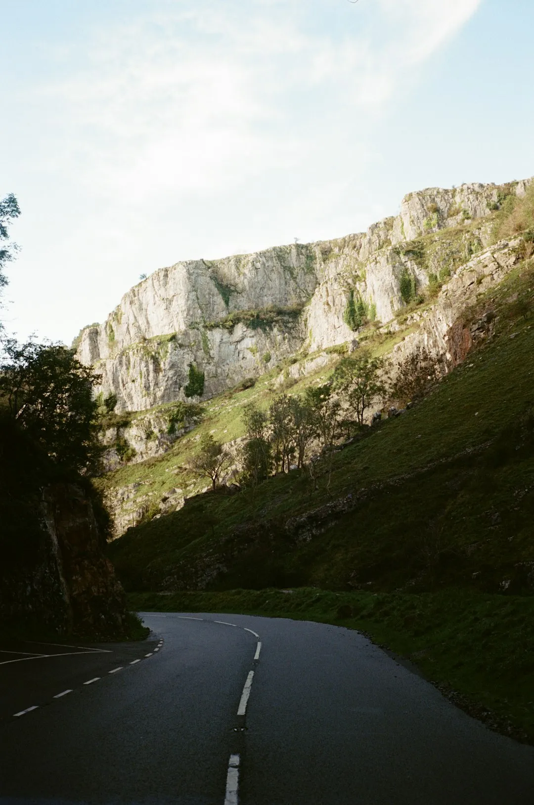
As the trail approaches Richmond, the landscape shifts. The valley narrows, and the path climbs onto the limestone scars of Applegarth. From this elevated vantage point, walkers are treated to panoramic views of the Cleveland Hills in the distance—the final mountain range of the Coast to Coast journey. The descent into Richmond is spectacular, as the massive keep of the castle grows larger on the horizon, eventually leading walkers directly into the cobbled market square. This section is not merely a walk between two points; it is a curated experience of English heritage, geology, and the enduring beauty of the Yorkshire Dales.
History and Cultural Context
The Coast to Coast Walk was first devised and popularised by Alfred Wainwright in his 1973 guidebook, "A Coast to Coast Walk." Wainwright, a legendary fell-walker and author, designed the route to link three of England's National Parks: the Lake District, the Yorkshire Dales, and the North York Moors. His intention was to create a route that was "unofficial"—a path that encouraged walkers to find their own way across the landscape rather than following a strictly mandated government trail. For decades, the route relied on the goodwill of local landowners and the navigational skills of hikers. However, its immense popularity eventually led to its official designation as a National Trail in 2022, ensuring its preservation and maintenance for future generations.
The specific section between Reeth and Richmond is steeped in much older history. Swaledale was once a thriving centre for lead mining, a heritage that is still visible in the spoil heaps and ruined smelt mills found in the side valleys. The dry-stone walls that define the landscape were largely constructed during the Enclosure Acts of the 18th and 19th centuries, though some foundations date back to the medieval period. These walls are built without mortar, relying entirely on the skill of the "waller" to balance stones in a way that allows wind and water to pass through while keeping livestock contained.
Richmond itself is a town of immense historical significance. Founded in 1071 by Alan Rufus, a companion of William the Conqueror, the town grew around its castle, which was designed to subdue the rebellious North of England. The town's market square is one of the largest in the country, and its medieval street plan remains largely intact. Walking into Richmond at the end of the day, hikers follow in the footsteps of Roman soldiers, medieval monks, and Victorian travellers, all of whom were drawn to this strategic and beautiful location on the banks of the Swale.
Want more background? Read extended notes on history and cultural context → Learn more
Seasonal Highlights and Weather Reality
The Coast to Coast Walk is best experienced between May and September, when the days are longest and the weather is most reliable. However, being in Northern England, walkers must be prepared for "four seasons in one day" regardless of the month. The Yorkshire Dales are notorious for sudden shifts in conditions, where bright sunshine can be replaced by heavy rain and mist within thirty minutes.
Spring (April to May): This is a beautiful time to walk, as the valley floors are carpeted with wildflowers and the lambs are in the fields. The air is crisp, and the visibility is often excellent. However, the ground can be very boggy after the winter rains, particularly in the wooded sections near Marrick. Temperatures typically range from 8°C to 14°C.
Summer (June to August): This is the peak season. The heather on the higher moors begins to turn purple in late August, and the hay meadows are at their most vibrant. While heatwaves are possible (with temperatures reaching 25°C or higher), the primary challenge is often the humidity and the occasional summer thunderstorm. This is also the busiest time on the trail, so expect to share the path with many other hikers.
Autumn (September to October): Many regular walkers consider September the best month. The "peak" crowds have dispersed, the air is cooler (10°C to 16°C), and the autumn colours in the woodlands around Marske and Richmond are stunning. The light in the late afternoon has a golden quality that is perfect for photography. By late October, the risk of frost and shorter daylight hours becomes a significant factor.
Winter (November to March): Walking this section in winter requires significant preparation. While the route does not reach high alpine altitudes, the limestone scars can become dangerously slippery when icy, and the riverside paths are prone to flooding. Daylight is limited, with the sun setting as early as 4:00 PM in December. This is only recommended for experienced walkers with appropriate cold-weather gear and navigation skills.
Recommended Itinerary
Reeth to Richmond Route Progression
The Departure: Reeth Green to Marrick Priory
- Distance: 5.5 km
- Time: 1.5–2 hours
- Start at the Reeth village green, heading east toward the River Swale.
- Follow the well-marked footpath through a series of small fields, crossing traditional stone stiles.
- The path stays relatively level, offering views of the river to your right and the rising moors to your left.
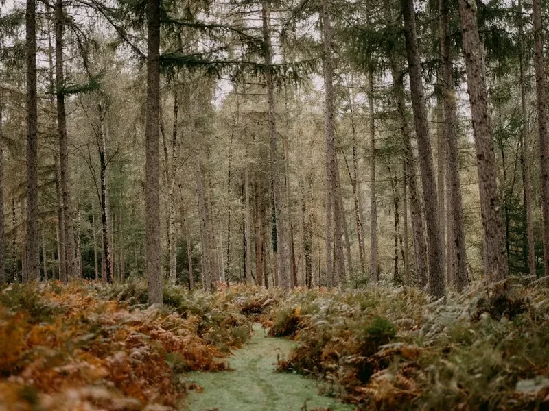
- Pass through the woodland near Marrick, where the path begins a gentle descent.
- Reach the "Nuns' Steps"—an ancient stone staircase that leads down to the valley floor.
- Arrive at Marrick Priory, a 12th-century ruin now used as an outdoor education centre. This is an ideal spot for a short break to admire the medieval stonework.
The Mid-Section: Marrick to Marske
- Distance: 4.5 km
- Time: 1.5 hours
- From the Priory, the path follows a quiet track through the woods, staying close to the river.
- The terrain is undulating but generally easy underfoot, though it can be muddy after rain.
- Cross the bridge into the village of Marske, a quiet and exceptionally pretty settlement.
- Marske is famous for its hall and its ancient church, St Edmund's, which dates back to the 12th century.
- There are no shops in Marske, but there is a public bench near the bridge that serves as a good midday rest point.
The Ascent: Marske to Applegarth Scars
- Distance: 5 km
- Time: 2 hours
- Leaving Marske, the trail begins its most significant climb of the day.
- The path ascends through fields toward the limestone cliffs known as Applegarth Scars.
- As you gain elevation, the views back toward Swaledale open up, revealing the scale of the valley.
- The route traverses the top of the scars, passing through High Applegarth and Low Applegarth farms.
- Keep an eye out for kestrels and buzzards, which often hunt along the cliff edges.
- This section can be exposed to the wind, so ensure you have an extra layer ready.
The Final Approach: Applegarth to Richmond
- Distance: 4.3 km
- Time: 1–1.5 hours
- The path begins a gradual descent from the scars, entering the outskirts of Richmond.
- Pass through Whitcliffe Woods, where the trail becomes a wide, well-maintained track.
- The first views of Richmond Castle appear through the trees—a dramatic sight as the fortress sits perched on a cliff above the river.
- The path leads directly into the town, passing the falls on the River Swale (Richmond Falls).
- Follow the steep, narrow streets up into the Market Place to finish the walk.
- Celebrate your arrival at one of the many historic pubs or tea rooms in the square.
Important Notes:
- The route is generally well-signed with the "Coast to Coast" acorn or arrow symbols, but a map is still essential.
- Public transport between Richmond and Reeth is limited (Bus 30), so check timetables in advance if you are not using a taxi.
- Many fields contain livestock; always keep dogs on a lead and give cattle a wide berth.
- The "Nuns' Steps" can be very slippery when wet; use trekking poles if available.
Planning and Bookings
Book Your Trip
Everything you need to plan your journey
Accommodation
Find places to stay near Richmond
Flights
Search flights to Richmond
Essential Preparation
While this is a day walk, it covers nearly 20 kilometres of varied terrain and requires a good level of cardiovascular fitness. Walkers should be comfortable being on their feet for 6 to 8 hours. Because this is a point-to-point walk, logistics are the most critical part of your preparation. Most walkers choose to base themselves in Richmond, which has a wider range of services, and take a taxi or the local bus (Little 30) to Reeth in the morning to walk back. This allows you to finish the walk at your own pace without worrying about catching a return bus.
Richmond is a well-equipped town with several supermarkets, outdoor gear shops, and a pharmacy. Reeth is smaller but has a good village store and several pubs. It is highly recommended to book your transport or accommodation at least a few weeks in advance, especially during the summer months when the Coast to Coast Walk is at its peak capacity. Ensure your mobile phone is fully charged, but do not rely on it for navigation, as signal can be intermittent in the deeper parts of the valley.
Trail Accommodation
As this is a day section, overnight accommodation on the trail itself is not required, but there are excellent options at both the start and end points. In Reeth, the accommodation is primarily traditional: cosy B&Bs, the historic Buck Hotel, and the Black Bull Inn. There is also a popular campsite (Orchard Caravan and Camping Park) located right in the village.
In Richmond, the options are more diverse. You will find everything from budget-friendly hostels and hikers' bunkhouses to high-end boutique hotels and traditional coaching inns. For those walking the full Coast to Coast, Richmond is a popular "rest day" location due to its wealth of amenities. If you are planning to stay in Richmond, look for accommodation near the Market Place for easy access to the trailhead and restaurants. Note that during the peak season (June–August), many B&Bs require a two-night minimum stay, so plan accordingly.
Required Gear
- Footwear: Sturdy, waterproof hiking boots with good ankle support are essential. The terrain includes rocky paths and muddy fields where trainers will not suffice.
- Waterproofs: A high-quality waterproof jacket and overtrousers. The weather in North Yorkshire is unpredictable, and staying dry is the key to safety and comfort.
- Navigation: OS Explorer Map OL30 (Yorkshire Dales - Northern & Central areas) and a compass. A GPS device or phone app (like OS Maps) is a great backup.
- Backpack: A 20–30 litre daypack with a waterproof cover or internal dry bags.
- Clothing: Layering is essential. Use moisture-wicking base layers (merino wool or synthetic), a warm fleece mid-layer, and avoid denim, which becomes heavy and cold when wet.
- Safety: A basic first aid kit (including blister plasters), a whistle, and a silver emergency blanket.
- Sun Protection: Even on overcast days, the wind on the scars can mask the intensity of the sun. Bring SPF 30+ sunscreen and a hat.
What to Bring
- Water: At least 2 litres per person. There are no reliable public water fountains between Reeth and Richmond, and drinking from the Swale is not recommended due to agricultural runoff.
- Food: A substantial packed lunch plus high-energy snacks (nuts, dried fruit, chocolate). While there are pubs in Reeth and Richmond, there are no food stops in Marrick or Marske.
- Electrolytes: On warmer days, electrolyte tablets can help prevent cramping during the climb to Applegarth.
- Cash: Some small honesty stalls in villages may sell cakes or eggs, and some local buses may prefer cash (though most now take contactless).
- Power Bank: To ensure your phone remains charged for photos and emergency calls.
- Trekking Poles: Highly recommended for the descent of the Nuns' Steps and the final descent into Richmond to save your knees.
Permits
One of the great joys of walking in England is the "Right to Roam" and the extensive network of Public Rights of Way. No permits, fees, or registrations are required to walk the Coast to Coast path. The route follows established public footpaths and bridleways that cross both public and private land. However, this freedom comes with the responsibility to follow the Countryside Code.
Access Rights:
- You are permitted to walk on any path marked as a Public Footpath (yellow arrows) or Public Bridleway (blue arrows).
- The Coast to Coast Walk is currently being upgraded to National Trail status, which means signage is becoming more consistent, but you must still respect "Private - No Entry" signs on land adjacent to the path.
- There are no "check-ins" or daily limits for this trail, making it one of the most accessible long-distance routes in the world.
Parking and Logistics Costs:
- Parking in Reeth: There is an honesty box system for parking on the village green (approx. £2–£3 per day).
- Parking in Richmond: Long-stay parking is available at Nuns Close Car Park or the Yorke Square Car Park (approx. £6–£8 per day).
- Public Transport: The bus from Richmond to Reeth costs approximately £2–£4 for a single journey under the current national fare cap.
- Taxis: A pre-booked taxi between Richmond and Reeth typically costs between £25 and £35. It is advisable to book these at least 24 hours in advance.
Other Activities in the Area
If you have extra time in Richmond or Reeth, the area offers a wealth of cultural and outdoor experiences:
- Richmond Castle: Explore the massive keep and the "Cockpit" garden. The views from the top of the keep over the Swale Valley are the best in the town.
- The Green Howards Museum: Located in the centre of Richmond, this museum tells the fascinating story of one of the British Army's most famous infantry regiments.
- The Georgian Theatre Royal: Built in 1788, this is the oldest working theatre in Britain in its original form. Guided tours are available daily.
- Easby Abbey: A pleasant 1.5 km flat walk from Richmond along the river leads to these extensive and beautiful Premonstratensian ruins.
- Swale Trail: For those who prefer two wheels, the Swale Trail is a 20 km mountain bike route that runs roughly parallel to the walking path between Reeth and Keld.
- Richmond Falls: A series of dramatic waterfalls on the River Swale right at the edge of the town, perfect for a picnic or a quick dip on a hot summer day.
Safety and Conditions
Navigation and Visibility: While the path is generally well-trodden, the section over Applegarth Scars can become confusing in thick fog or "haar" (sea mist that occasionally rolls in). Always carry a physical map and compass and know how to use them. Do not rely solely on following other walkers, as many paths intersect in this area.
Livestock Safety: You will pass through many fields containing sheep and cattle. During the spring (lambing season) and early summer, cows can be protective of their calves. If you have a dog, keep it on a short lead. If cattle approach you aggressively, let the dog off the lead—the cattle will chase the dog, and the dog will easily outrun them, allowing you to reach safety. Always close gates behind you to prevent livestock from escaping.
Terrain Hazards: The limestone in this region becomes exceptionally slippery when wet. The "Nuns' Steps" and the rocky sections of Applegarth Scars require careful foot placement. In winter, these areas can hold black ice. Additionally, the River Swale is known as the fastest-flowing river in England; never attempt to ford it if the water is high or if the path is flooded.
Emergency Contacts: In the event of an emergency, dial 999 or 112 and ask for "Police" and then "Mountain Rescue." Be prepared to give your location using a grid reference or a "What3Words" address. Note that mobile reception is very poor in the valley bottom near Marrick Priory.
Side Trips and Points of Interest
Marrick Priory: This is the most significant historical site on the route. Founded around 1154, it served as a Benedictine nunnery for nearly 400 years until the Dissolution of the Monasteries under Henry VIII. The church tower still stands, and the surrounding graveyard contains stones dating back centuries. It is a place of profound quiet and a highlight for history enthusiasts.
The Nuns' Steps: Legend has it that these 375 stone flags were laid by the nuns of Marrick Priory to provide a dry path to the village of Marrick on the hill above. Whether or not the legend is true, the steps are a remarkable piece of ancient engineering and provide a unique walking experience through the steep woodland.
Applegarth Scars: These limestone cliffs offer a dramatic geological contrast to the green fields of the valley. The "scars" are the result of glacial erosion and the weathering of the Carboniferous limestone. The area is a haven for birdlife, including peregrine falcons, and the flat plateau at the top provides the best lunch spot on the entire day's walk.
Richmond Falls: As you enter Richmond, the River Swale tumbles over a series of limestone steps. This was a popular spot for Victorian tourists and remains a favourite for locals today. The power of the water is a reminder of the force that shaped the valley you have just walked through.
Leave No Trace
The Yorkshire Dales is a living, working landscape. Much of the land you walk across is privately owned and used for agriculture. To ensure the trail remains open and beautiful for everyone, please adhere to the following principles:
- Take your litter home: There are no bins on the trail. This includes organic waste like banana skins and orange peels, which take a long time to decompose in the cool upland climate and can be harmful to local wildlife.
- Stick to the path: To prevent erosion and protect the delicate hay meadows (some of the rarest habitats in the UK), always walk in single file in the centre of the path.
- Respect the walls: Never climb over dry-stone walls. Use the provided stiles or gates. These walls are expensive and time-consuming to repair.
- No fires or BBQs: The moorland and woodland are highly susceptible to fire, especially in the summer months.
- Keep dogs under control: This is a high-livestock area. A dog chasing sheep can cause miscarriages in ewes or lead to the dog being legally shot by a farmer.
- Leave what you find: Do not pick wildflowers or remove stones from the walls or ruins.