
Coast to Coast Walk - England's Ultimate Cross-Country Odyssey
The Coast to Coast Walk is arguably the most famous long-distance trail in the United Kingdom, a 309-kilometre journey that traverses the width of Northern England. Conceived by the legendary fell-walker and author Alfred Wainwright in 1973, the route links the Irish Sea at St Bees in Cumbria to the North Sea at Robin Hood's Bay in North Yorkshire. This is not merely a walk; it is a pilgrimage through the changing soul of the English landscape. The trail weaves through three distinct and spectacular National Parks: the rugged, glaciated peaks of the Lake District; the rolling limestone scars and pastoral valleys of the Yorkshire Dales; and the vast, purple-clad heather moorlands of the North York Moors. With a total elevation gain of approximately 8,000 metres—nearly the height of Mount Everest—the Coast to Coast demands physical resilience, navigational competence, and an appreciation for the unpredictable British weather. It remains an unofficial route, largely following public rights of way, which adds a sense of discovery and personal challenge to every step. From the red sandstone cliffs of the west to the dramatic Jurassic coastline of the east, this walk offers a definitive cross-section of England's natural beauty, rural heritage, and geological diversity.
- Distance: 309.0 km
- Duration: 12–14 days
- Elevation Gain: 8,000 m
- Difficulty: Challenging
- Best Time: May to September (late spring to early autumn)
- Start Point: St Bees, Cumbria (Irish Sea)
- End Point: Robin Hood's Bay, North Yorkshire (North Sea)
- National Parks: Lake District, Yorkshire Dales, North York Moors
Overview
The Coast to Coast Walk is a masterclass in landscape transition. Unlike many trails that follow a single mountain range or coastline, the "C2C" provides a constantly evolving backdrop that prevents any hint of monotony. The journey is traditionally walked from west to east, keeping the prevailing wind and rain at the walker's back and allowing the dramatic scenery of the Lake District to serve as a powerful opening act. The walk begins with a symbolic gesture: walkers traditionally dip their booted feet in the Irish Sea at St Bees and pocket a pebble, which they will carry across the country to deposit in the North Sea at Robin Hood's Bay.
The first third of the walk is dominated by the Lake District National Park. This is the most strenuous section, featuring steep ascents over mountain passes like Loft Beck and Kidsty Pike (the highest point on the trail at 780 metres). The terrain is rocky, often wet, and requires a high degree of fitness. However, the rewards are immense: views of iconic fells, deep glacial lakes like Ennerdale Water and Ullswater, and the charming stone-built villages of Rosthwaite and Grasmere. This section tests the legs and the lungs, preparing the walker for the miles ahead.
As the trail leaves the Lake District, it crosses the Westmorland Plateau toward the Yorkshire Dales. The landscape softens into "limestone country," characterised by dramatic scars, deep caves, and the iconic dry-stone walls that criss-cross the emerald-green valleys (dales). The crossing of Nine Standards Rigg marks the watershed of England; from this point forward, all rivers flow east toward the North Sea. The Dales section offers a mix of high moorland walking and riverside paths along the River Swale, passing through historic lead-mining areas and the beautiful village of Reeth.
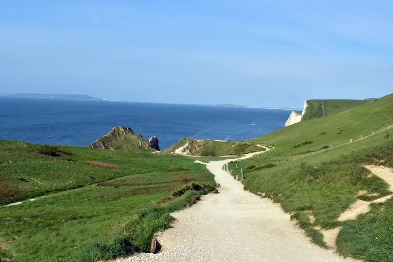
The final leg traverses the Vale of Mowbray—a flat, agricultural stretch that provides a brief respite for the feet—before rising into the North York Moors National Park. Here, the trail follows the escarpment of the Cleveland Hills, offering vast views across the Tees Valley before plunging into the expansive heather moors. The final day is a spectacular cliff-top walk along the North Sea coast, culminating in a steep descent into the narrow, winding streets of Robin Hood's Bay. Completing the walk is a profound achievement, celebrated with a final pint at the Bay Hotel and the ceremonial tossing of the St Bees pebble into the waves.
History and Cultural Context
The Coast to Coast Walk is unique among world-class trails because it was the creation of a single individual rather than a historical trade route or a government-mandated path. Alfred Wainwright, a quiet accountant from Blackburn who became the most influential chronicler of the English fells, published "A Coast to Coast Walk" in 1973. His intention was to encourage people to look beyond the established National Trails and find their own way across the country. Wainwright’s hand-drawn maps and idiosyncratic commentary turned the route into an instant classic, and it has since become one of the most popular long-distance walks in the world.
While the route itself is modern, the paths it follows are ancient. Walkers tread upon Roman roads, medieval "corpse roads" used to transport the dead to consecrated ground, and 18th-century packhorse tracks used by traders. In the Lake District, the trail passes through landscapes that inspired the Romantic poets, most notably William Wordsworth, whose home in Grasmere lies directly on the route. In the Yorkshire Dales, the ruins of lead mines and smelting chimneys serve as a reminder of the industrial heritage that once dominated these now-peaceful valleys. The North York Moors section follows the "Ironstone" routes, where Victorian industry extracted ore from the hillsides.
Culturally, the walk is a journey through the heart of rural England. It passes through communities that have remained largely unchanged for centuries, where sheep farming is still the primary way of life. The tradition of the "C2C" has become an integral part of these villages; local pubs and B&Bs have hosted decades of weary walkers, creating a unique culture of camaraderie. In 2022, the UK government announced that the Coast to Coast would be formally designated as a National Trail, a move that will bring increased funding and improved signage to the route, ensuring its preservation for future generations while maintaining the spirit of Wainwright’s original vision.
Want more background? Read extended notes on history and cultural context → Learn more
Seasonal Highlights and Weather Reality
The Coast to Coast Walk is best attempted between May and September. During this window, the days are long, the ground is generally drier, and the services (accommodation and baggage transfer) are in full operation. However, the British weather is notoriously fickle, and walkers must be prepared for "four seasons in one day" regardless of the month.
Spring (May–June): Many consider this the prime time for the walk. The Lake District is vibrant with new green growth, bluebells carpet the woodlands, and the weather is often surprisingly stable. The days are approaching their longest, providing ample daylight for the more strenuous stages. However, late snow can occasionally linger on the higher fells of the Lake District, and the "boggy" sections of the Dales can still be very soft after winter rains.
Summer (July–August): This is the warmest period, with temperatures typically ranging from 15°C to 25°C. The heather on the North York Moors begins to bloom in late August, turning the landscape a stunning shade of purple. This is also the busiest season; accommodation must be booked many months in advance, and the trail can feel social. The main challenge in summer is the lack of shade on the high moors and the potential for sudden, heavy thunderstorms.
Autumn (September–October): September offers cooler walking temperatures and beautiful autumnal colours, particularly in the wooded valleys of the Dales. The crowds begin to thin, and the light becomes softer and more photogenic. By October, however, the days shorten significantly, and the risk of prolonged Atlantic storms increases. Many B&Bs and baggage services begin to close for the season in mid-October.
Winter (November–April): Attempting the Coast to Coast in winter is a serious undertaking reserved for experienced mountaineers. The Lake District fells become true alpine environments requiring ice axes and crampons. Navigation becomes extremely difficult in frequent mist and snow, and many sections of the trail become impassable due to flooding or deep snowdrifts. Most support infrastructure is closed, making logistics nearly impossible for the average walker.
Recommended Itinerary
14-Day Coast to Coast Itinerary
Day 1: St Bees to Ennerdale Bridge
- Distance: 22.5 km
- Elevation gain: 750 m
- Time: 6–7 hours
- Start by dipping boots in the Irish Sea and collecting a pebble
- Follow the dramatic red sandstone cliffs of St Bees Head
- Turn inland through the villages of Sandwith and Moor Row
- First taste of the Lake District fells as you climb Dent Hill
- Descend into the quiet valley of Ennerdale
Day 2: Ennerdale Bridge to Rosthwaite
- Distance: 23.5 km
- Elevation gain: 700 m
- Time: 7–8 hours
- Walk the length of Ennerdale Water, a remote and beautiful lake
- Pass the Black Sail Youth Hostel, the most remote in England
- Steep climb up Loft Beck onto the high fells
- Spectacular views of Great Gable and the Scafell range
- Descend into the lush Borrowdale Valley to the village of Rosthwaite
Day 3: Rosthwaite to Grasmere
- Distance: 14.5 km
- Elevation gain: 550 m
- Time: 5–6 hours
- A shorter but steep day crossing the spine of the Lake District
- Climb alongside Lining Crag to the Greenup Edge pass
- Navigate the often-boggy plateau before descending into Far Easedale
- Arrive in Grasmere, the heart of the Lakes and home to Wordsworth
Day 4: Grasmere to Patterdale
- Distance: 14 km
- Elevation gain: 650 m
- Time: 5–6 hours
- Climb to Grisedale Tarn, a stunning mountain lake nestled between peaks
- Optional ascent of Helvellyn (950 m) for experienced walkers
- Descend the long, scenic Grisedale Valley
- Arrive in Patterdale near the shores of Ullswater
Day 5: Patterdale to Shap
- Distance: 26 km
- Elevation gain: 950 m
- Time: 8–9 hours
- The hardest day in the Lakes: a long climb to Kidsty Pike (780 m)
- Last views over the high fells before descending to Haweswater Reservoir
- Follow the shoreline of Haweswater for several kilometres
- Pass the ruins of Shap Abbey before entering the village of Shap
Day 6: Shap to Kirkby Stephen
- Distance: 32 km
- Elevation gain: 500 m
- Time: 8–9 hours
- Leave the Lake District for the limestone plateau of the Westmorland Fells
- Pass the "Sunbiggin Tarn" and the dramatic Smardale Viaduct
- Enter the Yorkshire Dales National Park
- Arrive in the historic market town of Kirkby Stephen
Day 7: Kirkby Stephen to Keld
- Distance: 20 km
- Elevation gain: 650 m
- Time: 6–7 hours
- Climb to the Nine Standards Rigg, marked by nine ancient stone cairns
- Cross the watershed of England (rivers now flow east)
- Navigate the notorious peat bogs of the high moorland
- Descend into Swaledale to the tiny, picturesque hamlet of Keld
Day 8: Keld to Reeth
- Distance: 18 km
- Elevation gain: 450 m
- Time: 5–6 hours
- Two route options: the high route via old lead mines or the low route along the River Swale
- The high route offers haunting industrial ruins and vast views
- The low route passes through flower-rich hay meadows and stone barns
- Arrive in Reeth, a classic Dales village with a large central green
Day 9: Reeth to Richmond
- Distance: 17 km
- Elevation gain: 300 m
- Time: 4–5 hours
- A gentler day following the River Swale through woodland and pasture
- Pass the ruins of Marrick Priory
- Enter Richmond, a major town dominated by its massive Norman castle
- Excellent opportunity for a rest or resupply
Day 10: Richmond to Ingleby Cross
- Distance: 37 km
- Elevation gain: 200 m
- Time: 9–10 hours
- The longest day distance-wise, crossing the flat Vale of Mowbray
- Mostly agricultural land and quiet country lanes
- A test of mental endurance rather than physical climbing
- Arrive at the edge of the North York Moors
Day 11: Ingleby Cross to Clay Bank Top
- Distance: 19 km
- Elevation gain: 750 m
- Time: 6–7 hours
- Enter the North York Moors National Park
- A series of steep climbs and descents over the Cleveland Hills
- Pass the "Lordstones" viewpoint
- Spectacular views north toward Middlesbrough and the Tees estuary
Day 12: Clay Bank Top to Glaisdale
- Distance: 29 km
- Elevation gain: 400 m
- Time: 8–9 hours
- Walk across the high, open heather moorland
- Follow the route of an old ironstone railway
- Pass the "Lion Inn" at Blakey Ridge, the highest pub on the route
- Descend into the quiet, wooded valley of Glaisdale
Day 13: Glaisdale to Littlebeck
- Distance: 13 km
- Elevation gain: 300 m
- Time: 4–5 hours
- A shorter day through the beautiful Esk Valley
- Pass through Egton Bridge and the ancient woods of Arncliffe Woods
- Visit the "Falling Foss" waterfall and the hermitage carved into a boulder
- Arrive in the tiny valley of Littlebeck
Day 14: Littlebeck to Robin Hood's Bay
- Distance: 25 km
- Elevation gain: 500 m
- Time: 7–8 hours
- Cross the final stretch of moorland at Sneaton High Moor
- Reach the North Sea coast at Hawsker
- Follow the dramatic cliff-top path for the final 5 kilometres
- Descend the steep hill into Robin Hood's Bay to finish at the Bay Hotel
- Dip boots in the sea and deposit your St Bees pebble
Planning and Bookings
Book Your Trip
Everything you need to plan your journey
Accommodation
Find places to stay near Lancaster
Flights
Search flights to Lancaster
Essential Preparation
The Coast to Coast Walk requires significant logistical planning, primarily due to its length and the popularity of certain villages. Most walkers take between 12 and 15 days, though 14 days is the standard "comfortable" pace. Fitness is paramount; you should be capable of walking 25 kilometres a day with significant elevation gain for multiple consecutive days. Training with a weighted pack on hilly terrain is highly recommended.
Logistically, the walk is usually tackled from West to East. The nearest major airport is Manchester (MAN), which has direct train links to Lancaster. From Lancaster, you can take a local train to St Bees. At the end of the walk, buses run from Robin Hood's Bay to Whitby or Scarborough, where train connections back to major cities are available. Many walkers use a baggage transfer service (such as Sherpa Van or Packhorse), which moves your main luggage between accommodations each day, allowing you to walk with only a daypack.
Trail Accommodation
Accommodation on the Coast to Coast is varied but can be a bottleneck in the planning process. Because the trail passes through small hamlets with limited beds, booking 6–12 months in advance is essential for the peak summer months.
Types of Accommodation:
- Bed & Breakfasts (B&Bs): The most common choice. Usually includes a room in a private home or small inn with a full English breakfast. Costs range from £80–£120 per night for a double room.
- Inns and Pubs: Many historic pubs along the route offer rooms. These are social hubs where you will meet fellow walkers.
- Youth Hostels (YHA): Located in Ennerdale, Rosthwaite, Grasmere, Patterdale, and Kirkby Stephen. These offer budget-friendly dorms or private rooms and self-catering kitchens.
- Campsites: Available in almost every stopping point. Some are basic farm fields, while others have full shower facilities. Wild camping is technically illegal in England without landowner permission, though it is tolerated in some higher parts of the Lake District if done responsibly and discreetly.
- Bunkhouses: Simple, communal accommodation often found on farms, providing a mattress and basic kitchen facilities.
What's Provided: Most B&Bs and inns provide bedding, towels, and breakfast. Many will also provide a packed lunch for an additional fee (usually £7–£10). Drying rooms for wet gear are a standard feature in most walker-friendly accommodations.
Required Gear
- Footwear: High-quality, waterproof hiking boots with good ankle support. Ensure they are thoroughly broken in before starting. The terrain varies from sharp rock to deep mud.
- Waterproofs: A high-end waterproof jacket and overtrousers (Gore-Tex or similar). The British rain can be relentless and wind-driven.
- Navigation: Ordnance Survey (OS) maps (1:25,000 scale) or a dedicated C2C guidebook (Wainwright or Stedman). A GPS or smartphone app (like OS Maps or Komoot) is excellent, but a physical map and compass are essential backups as batteries fail and signals drop in deep valleys.
- Backpack: A 30–40L daypack if using baggage transfer, or a 55–65L pack if carrying all your gear. Ensure it has a waterproof rain cover.
- Clothing: A layering system is vital. Use moisture-wicking base layers (merino wool is excellent), a fleece mid-layer, and a lightweight insulated jacket for stops. Avoid cotton, which stays cold and heavy when wet.
- Safety Gear: A whistle, a basic first aid kit (heavy on blister care like Compeed), and a survival bag or lightweight bivvy.
What to Bring
- Water Treatment: While tap water in accommodations is safe, you may need to refill from streams on long days. Use a filter bottle (like LifeStraw) or purification tablets, as upland streams can be contaminated by sheep.
- Food and Snacks: High-energy snacks (nuts, dried fruit, chocolate). While you can buy lunch in most villages, some stages (like Patterdale to Shap) have no shops for the entire day.
- Toiletries: Sunscreen (the wind can mask the sun's strength), lip balm, and insect repellent (midges can be an issue in the Lake District in summer).
- Personal Items: A portable power bank for your phone/GPS, a lightweight travel towel (if hostelling), and earplugs (essential for communal dorms or noisy pubs).
- Cash: While most places take cards, some small tea rooms or honesty boxes on farms still require cash (GBP).
Permits
One of the great appeals of the Coast to Coast Walk is that no permits or fees are required to walk the trail. The route follows public rights of way, which are legally protected paths across both public and private land. You are free to walk the trail at any time without registration.
Access Rights and Responsibilities:
- Public Footpaths: Open to walkers only. You must stay on the marked path when crossing farmland.
- Bridleways: Open to walkers, cyclists, and horse riders.
- Open Access Land: In many upland areas of the Lake District and the Moors, you have the "Right to Roam" across open country, though the C2C usually follows established tracks.
- National Park Regulations: While there are no entry fees for the Lake District, Yorkshire Dales, or North York Moors, you must adhere to the Countryside Code (leave gates as you find them, protect plants and animals, and take your litter home).
Designation as a National Trail: As of 2025, the route is undergoing a transition to official National Trail status. This does not change the permit-free nature of the walk, but it does mean that signage is becoming more standardised (look for the acorn symbol alongside the traditional C2C signs). It also means that certain sections are being upgraded to improve accessibility and reduce erosion in boggy areas.
Organised Tours: If you choose to book through a trekking company, they will handle your accommodation and baggage transfers for a fee, but the "permit" to walk remains free and universal.
Other Activities in the Area
If you have extra time before, during, or after your walk, Northern England offers a wealth of cultural and outdoor experiences:
- Grasmere Gingerbread: A visit to Sarah Nelson's famous shop in Grasmere is a mandatory stop for many walkers. The recipe has remained secret since 1854.
- Richmond Castle: Spend a morning exploring one of the best-preserved Norman fortresses in England, with commanding views over the River Swale.
- Whitby Abbey: Just a short bus ride from the finish at Robin Hood's Bay, these dramatic ruins inspired Bram Stoker's "Dracula."
- Steam Railways: The North York Moors Railway offers a nostalgic trip through the moors on a vintage steam train, passing through stations used in the Harry Potter films.
- Hardraw Force: Located near Hawes in the Dales, this is England's highest single-drop waterfall (30 metres), located behind a historic pub.
- Wordsworth Grasmere: Visit Dove Cottage, where William Wordsworth wrote some of his most famous poetry, located directly on the trail.
Safety and Conditions
Navigation and Visibility: The single greatest danger on the Coast to Coast is becoming lost in low visibility. The Lake District fells and the North York Moors are frequently shrouded in "clag" (thick mist). In these conditions, the trail can vanish, and features become indistinguishable. You must be able to use a map and compass. Do not rely solely on a smartphone, as cold temperatures and GPS usage drain batteries rapidly.
The "Bog" Factor: Several sections of the trail, particularly Nine Standards Rigg and the crossing of the North York Moors, are notorious for deep peat bogs. In wet weather, these can be knee-deep. Stick to the marked paths or the stone flags where provided. If you find yourself in a boggy area, look for tufts of darker "reedy" grass, which usually indicate firmer ground.
Weather Extremes: Hypothermia is a genuine risk even in summer. A combination of wet clothing, high winds, and exhaustion can lead to a dangerous drop in body temperature. Always carry a high-quality waterproof shell and a warm spare layer. Conversely, on the exposed moors, heat exhaustion and dehydration can occur during summer heatwaves; carry at least 2 litres of water on these stages.
Road Walking: The Vale of Mowbray section involves significant stretches of road walking. While these are mostly quiet country lanes, be aware of farm machinery and local traffic. Walk on the right-hand side of the road (facing oncoming traffic) and wear high-visibility gear if the light is fading.
Emergency Services: In an emergency, dial 999 or 112 and ask for "Police" and then "Mountain Rescue." Be prepared to give your exact location (a six-figure grid reference or a "What3Words" address).
Side Trips and Points of Interest
Helvellyn via Striding Edge: For those with a head for heights and good weather, the ascent of Helvellyn from Patterdale is a classic. Instead of the standard C2C route, you can take the narrow, rocky ridge of Striding Edge to the summit. This is a Grade 1 scramble and should not be attempted in high winds or wet conditions.
Nine Standards Rigg: These nine massive stone cairns stand on the summit of Hartley Fell. Their origin is unknown—some suggest they were built by the Roman army to look like distant sentries, while others believe they are boundary markers. They provide a haunting and atmospheric landmark at the midpoint of the walk.
The Lion Inn, Blakey Ridge: This 16th-century inn is the fourth-highest pub in England and sits in total isolation on the high moors. It is a legendary stop for C2C walkers, offering a warm fire and hearty food in a landscape that can feel incredibly bleak in bad weather.
Falling Foss: A hidden gem in the final stages of the walk. This 10-metre waterfall is tucked away in ancient woodland. Nearby is "The Hermitage," a cave carved into a massive gritstone boulder in the 18th century, reportedly used as a secluded retreat by a local hermit.
Robin Hood's Bay: The village itself is a point of interest. A former smuggling stronghold, its tiny alleys and "slipways" were designed to confuse excise men. Exploring the labyrinthine streets after finishing the walk is a perfect way to wind down.
Leave No Trace
The Coast to Coast Walk passes through some of England's most fragile ecosystems. With thousands of walkers completing the route annually, the cumulative impact can be significant. Adhering to Leave No Trace principles is essential to keep the trail sustainable.
Key Principles for the C2C:
- Stick to the Path: In the Lake District and the Dales, "braiding" (where walkers create multiple parallel paths to avoid mud) causes massive erosion. Walk through the mud, not around it, to keep the trail narrow.
- Litter: There are no bins on the fells or moors. Pack out everything, including biodegradable items like banana skins and orange peels, which take years to decompose in the cold upland climate.
- Human Waste: Use toilets in villages and pubs whenever possible. If you must go on the trail, ensure you are at least 50 metres from water sources and bury waste in a "cathole" 15cm deep. Pack out all toilet paper and sanitary products.
- Gates and Livestock: This is a working landscape. Always leave gates as you found them (usually closed). Keep dogs on a short lead near sheep, especially during lambing season (March–May).
- Wild Camping: If you must wild camp, arrive late, leave early, and ensure your site is invisible from the trail. Never light open fires; use a small camping stove instead.