Wainwright's Coast to Coast - England's Ultimate Cross-Country Odyssey
Wainwright's Coast to Coast is not merely a walk; it is a rite of passage for hikers across the globe. Stretching approximately 306 kilometres from the Irish Sea at St Bees to the North Sea at Robin Hood's Bay, this legendary thru-hike traverses the full width of Northern England. Conceived by the legendary fell-walker and author Alfred Wainwright in 1973, the route is a masterwork of landscape curation, linking three of the United Kingdom's most spectacular National Parks: the Lake District, the Yorkshire Dales, and the North York Moors. It is a journey of profound geographical and emotional transitions, moving from the rugged, glaciated peaks of Cumbria through the rolling limestone plateaus of the Pennines and finally across the expansive, purple-hued heather moors of North Yorkshire.
Unlike many official National Trails, the Coast to Coast was born from a personal vision of what a great walk should be—varied, challenging, and deeply connected to the character of the land. It remains one of the most popular long-distance trails in the world, despite its unofficial status for many decades (it was only recently granted National Trail status in 2022, with upgrades ongoing). The tradition of the walk is steeped in ritual: hikers begin by dipping their booted feet in the Irish Sea at St Bees and picking up a pebble, which they carry across the breadth of the country to deposit in the North Sea at Robin Hood's Bay. This simple act of carrying a piece of the west to the east symbolises the physical and spiritual continuity of the journey. It is a trail that demands stamina, rewards curiosity, and offers an unparalleled window into the soul of the English countryside.
- Distance: 306.0 km (approximate, depending on detours)
- Duration: 12–16 days
- Total Elevation Gain: 8,500 m
- Difficulty: Challenging (requires high fitness and navigation skills)
- Highest Point: Kidsty Pike (780 m)
- Start Point: St Bees, Cumbria
- End Point: Robin Hood's Bay, North Yorkshire
- National Parks Traversed: Lake District, Yorkshire Dales, North York Moors
Overview
The Coast to Coast is a symphony of three movements, each defined by a distinct geological and cultural character. The first movement, the Lake District, is arguably the most physically demanding and visually dramatic. Here, the trail climbs over high mountain passes, skirts deep glacial ribbons of water like Ennerdale and Haweswater, and navigates the rocky, often mist-shrouded fells that inspired the Romantic poets. The terrain is steep, the weather is famously unpredictable, and the sense of wilderness is at its peak. Walkers must contend with significant elevation changes daily, testing their knees and their resolve before descending into charming stone-built villages like Grasmere and Patterdale.
The second movement begins as the trail leaves the high peaks behind and enters the limestone country of the Yorkshire Dales. The landscape softens into rolling green hills, divided by an intricate lattice of dry-stone walls that have stood for centuries. This section features the iconic "Nine Standards Rigg"—a line of mysterious stone cairns standing sentinel on the edge of the Pennines—and the lush, waterfall-rich valley of Swaledale. The walking here is often across high moorland plateaus where the wind whistles through the grass, followed by descents into "Old England" villages where the local pub serves as the community's beating heart. The midpoint of the trail is marked by the market town of Kirkby Stephen, a vital logistical hub for weary travellers.
The final movement takes hikers across the Vale of Mowbray and into the North York Moors. After the steep climbs of the Lakes and the steady pulls of the Dales, the Moors offer a different kind of challenge: vast, open spaces where the horizon seems infinite. In late summer, these moors are transformed into a sea of vibrant purple heather. The trail follows ancient trods and dismantled railway lines, providing a sense of historical continuity. The journey concludes with a dramatic cliff-top walk along the North Sea coast, culminating in a steep descent into the narrow, winding streets of Robin Hood's Bay. The transition from the red sandstone cliffs of the west to the dark, fossil-rich shale of the east is a geological journey of millions of years, compressed into a fortnight of human effort.
History and Cultural Context
The Coast to Coast owes its existence to Alfred Wainwright (1907–1991), a man whose meticulous hand-drawn guidebooks redefined British fell-walking. Wainwright was a municipal accountant by trade, but his heart belonged to the mountains of Cumbria. In 1973, he published "A Coast to Coast Walk," intended as a successor to his famous "Pictorial Guides to the Lakeland Fells." His goal was to encourage people to look beyond the established boundaries of National Parks and see the interconnectedness of the English landscape. He famously stated that he wanted to provide a route that was "a continuous walk from one side of England to the other," and he did so with a characteristic blend of practical advice and poetic appreciation.
Culturally, the trail is a tapestry of English history. In the Lake District, you walk through landscapes shaped by Norse settlers and later by the mining and quarrying industries of the Victorian era. In the Yorkshire Dales, the trail passes through lead-mining ruins in Swaledale, where abandoned hushes and smelting chimneys stand as silent monuments to a vanished industrial past. The North York Moors are crisscrossed by ancient "corpse roads" and monastic paths used by monks travelling between the great abbeys of Rievaulx and Whitby. Even the start and end points are steeped in lore: St Bees is named after St Bega, an Irish princess who supposedly fled across the sea to escape a forced marriage, while Robin Hood's Bay was once a notorious haven for smugglers who used the labyrinthine alleys to evade the excise men.
For decades, the Coast to Coast remained an "unofficial" route, maintained by the goodwill of landowners and the footsteps of thousands of hikers. It was only in 2022 that the UK government announced it would become a National Trail, ensuring long-term funding for maintenance and signage. This transition marks a new chapter in the trail's history, balancing Wainwright's original "find-your-own-way" ethos with the need for sustainable tourism management in an increasingly popular outdoor destination.
Want more background? Read extended notes on history and cultural context → Learn more
Seasonal Highlights and Weather Reality
The Coast to Coast is a seasonal undertaking, with the vast majority of hikers attempting the route between April and October. Each season offers a distinct palette of colours and challenges. Spring (April to June) is perhaps the most popular time; the days are lengthening, the lambs are in the fields of the Dales, and the spring flowers are in bloom. However, the high fells of the Lake District can still hold snow well into April, and the ground is often saturated from winter rains, making the notorious "bogs" of the Pennines particularly treacherous.
Summer (July and August) offers the warmest weather and the most reliable conditions, but it also brings the largest crowds. Accommodation in popular villages like Grasmere and Richmond can be booked out months in advance. This is also the season of the "midge" in damp, sheltered valleys, though they are rarely as fierce as their Scottish cousins. The North York Moors are at their most spectacular in late August when the heather blooms, turning the hillsides into a carpet of royal purple.
Autumn (September to October) is many experienced hikers' favourite time. The air is crisp, the light is golden, and the bracken on the fells turns a deep russet brown. The crowds thin out, and the pubs feel even more welcoming with a roaring fire. However, the days shorten rapidly, and the risk of Atlantic storms bringing heavy rain and high winds increases. Winter (November to March) is only for the most experienced and well-equipped hikers. Many B&Bs and campsites close for the season, navigation becomes significantly harder in snow and low cloud, and the limited daylight hours make the longer stages nearly impossible without night-walking.
Regardless of the season, the "Weather Reality" of Northern England is that you should expect rain at any time. The Lake District is one of the wettest places in England, and it is entirely possible to experience four seasons in a single afternoon. Waterproofing is not an option; it is a survival requirement.
Recommended Itinerary
14-Day Coast to Coast Itinerary
Day 1: St Bees to Ennerdale Bridge
- Distance: 22.5 km
- Elevation gain: 750 m
- Time: 6–7 hours
- Start by dipping boots in the Irish Sea and collecting a pebble
- Dramatic cliff-top walk along St Bees Head (RSBP bird reserve)
- Inland transition through the villages of Sandwith and Moor Row
- First views of the Lake District mountains appearing on the horizon
- Steady climb over Dent Fell (450 m) for a panoramic view of the coast and the fells
- Descend into the quiet village of Ennerdale Bridge
Day 2: Ennerdale Bridge to Rosthwaite
- Distance: 23.5 km
- Elevation gain: 800 m
- Time: 7–8 hours
- Walk along the remote southern shore of Ennerdale Water
- Pass the Black Sail Youth Hostel, one of the most isolated in England
- Steep climb up Loft Beck to reach the high fells
- Traverse the rugged terrain beneath Great Gable and Brandreth
- Descend via the Honister Slate Mine into the beautiful Borrowdale Valley
- Stay in the charming hamlet of Rosthwaite
Day 3: Rosthwaite to Grasmere
- Distance: 14.5 km
- Elevation gain: 600 m
- Time: 5–6 hours
- A shorter but steep day crossing the heart of the Lakes
- Climb alongside Stonethwaite Beck up to Greenup Edge (600 m)
- Navigate the often-boggy plateau of the ridge
- Spectacular views of the Langdale Pikes and Easedale Tarn
- Long descent into Grasmere, the former home of William Wordsworth
- Excellent opportunity to try the world-famous Grasmere Gingerbread
Day 4: Grasmere to Patterdale
- Distance: 14 km
- Elevation gain: 650 m
- Time: 5–6 hours
- Climb out of Grasmere towards Grisedale Pass (600 m)
- Pass the atmospheric Grisedale Tarn, nestled between high peaks
- Optional detour: Summit Helvellyn (950 m) via Striding Edge for experienced hikers
- Steady descent through the glacial Grisedale Valley
- Arrive in Patterdale at the southern end of Ullswater
Day 5: Patterdale to Shap
- Distance: 26 km
- Elevation gain: 1,100 m
- Time: 8–9 hours
- The hardest day in the Lake District with significant climbing
- Steep ascent to Kidsty Pike (780 m), the highest point on the entire trail
- Breathtaking views over Haweswater Reservoir
- Long, undulating walk along the high ridge before descending to the ruins of Shap Abbey
- Finish in the village of Shap, crossing the M6 motorway—a jarring return to modernity
Day 6: Shap to Orton
- Distance: 13 km
- Elevation gain: 250 m
- Time: 3–4 hours
- A much-needed "recovery day" through limestone plateau country
- Walk across the Westmorland Fells with their unique "limestone pavement"
- Pass ancient stone circles and prehistoric settlements
- Arrive in the picturesque village of Orton, home to a famous chocolate factory
Day 7: Orton to Kirkby Stephen
- Distance: 21 km
- Elevation gain: 400 m
- Time: 6–7 hours
- Gentle rolling terrain through the Eden Valley
- Cross Smardale Gill via a spectacular Victorian railway viaduct
- Climb over Smardale Fell for views of the Pennines ahead
- Arrive in Kirkby Stephen, the traditional midpoint and a great place for a rest day
Day 8: Kirkby Stephen to Keld
- Distance: 20 km
- Elevation gain: 600 m
- Time: 6–7 hours
- Cross the "backbone of England"—the Pennine watershed
- Climb to the Nine Standards Rigg (650 m), iconic stone cairns
- Navigate the notorious peat bogs of the plateau (seasonal routes apply)
- Descend into Swaledale, entering the Yorkshire Dales National Park
- Finish in Keld, a tiny village famous for its numerous waterfalls
Day 9: Keld to Reeth
- Distance: 18 km
- Elevation gain: 450 m
- Time: 5–6 hours
- Two route options: High (over the moors) or Low (along the river)
- High route passes through dramatic lead-mining ruins at Old Gang Smelt Mill
- Low route follows the River Swale through flower-rich hay meadows
- Both routes converge in Reeth, a classic Dales village with a massive village green
Day 10: Reeth to Richmond
- Distance: 17 km
- Elevation gain: 300 m
- Time: 5–6 hours
- A gentler walk through the lower reaches of Swaledale
- Pass the ruins of Marrick Priory
- Walk through ancient woodland and across parkland
- Enter Richmond, a historic market town dominated by its massive Norman castle
- Richmond offers the best selection of shops and services since the start
Day 11: Richmond to Ingleby Cross
- Distance: 37 km (often split into two days)
- Elevation gain: 200 m
- Time: 9–11 hours
- The longest and flattest stage, crossing the Vale of Mowbray
- Mostly agricultural land, country lanes, and bridleways
- A test of mental endurance rather than physical climbing
- Pass through the village of Danby Wiske
- Finish at Ingleby Cross, at the foot of the North York Moors
Day 12: Ingleby Cross to Clay Bank Top
- Distance: 19 km
- Elevation gain: 750 m
- Time: 6–7 hours
- Enter the North York Moors National Park
- A series of steep "ups and downs" along the Cleveland Hills
- Pass the Wainstones, dramatic sandstone rock formations
- Spectacular views north towards Teesside and south across the moors
- Finish at the remote Clay Bank Top (requires transport to nearby accommodation)
Day 13: Clay Bank Top to Glaisdale
- Distance: 29 km
- Elevation gain: 350 m
- Time: 8–9 hours
- Walk along the "Lion Inn" ridge, following an ancient dismantled railway
- Vast, open moorland scenery—the quintessential North York Moors experience
- Pass the "Fat Betty" and "Young Ralph" ancient stone crosses
- Long, steady descent into the wooded valley of Glaisdale
- Cross the medieval Beggar's Bridge
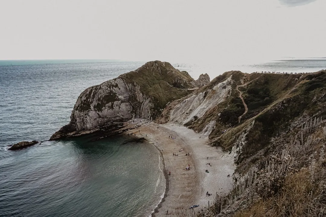
Day 14: Glaisdale to Robin Hood's Bay
- Distance: 31 km
- Elevation gain: 500 m
- Time: 8–10 hours
- The final push to the sea
- Walk through Egton Bridge and Grosmont (home to the North Yorkshire Moors Railway)
- Final climb onto the moors at Sleights Moor
- First glimpse of the North Sea and Whitby Abbey in the distance
- Dramatic cliff-top finish from Hawsker to Robin Hood's Bay
- Descend the steep village street to dip boots in the sea and deposit the pebble
Planning and Bookings
Book Your Trip
Everything you need to plan your journey
Accommodation
Find places to stay near Kirkby Stephen
Flights
Search flights to Kirkby Stephen
Essential Preparation
The Coast to Coast is a significant physical undertaking. Even fit walkers will find the consecutive days of 20–30 km distances challenging. Training should focus on hill walking with a weighted pack. Because the trail is not a single managed entity, logistics require careful coordination. You must decide whether to carry your own gear or use a luggage transfer service (highly recommended for most). Kirkby Stephen is the logical midpoint for a rest day or for those wishing to split the walk into two separate trips.
Transport to the start at St Bees is best handled by train via Carlisle or Lancaster. The finish at Robin Hood's Bay is more remote; most hikers take a bus to Whitby or Scarborough and then a train onward. Booking accommodation at least 6 months in advance is essential for the peak months of May, June, and September.
Trail Accommodation
The trail relies on a network of private and commercial accommodation. There are no "huts" in the New Zealand or Alpine sense, but rather a mix of traditional English hospitality options.
Accommodation Types:
- Bed & Breakfasts (B&Bs): The backbone of the trail. Usually private homes or small guesthouses. Expect a "Full English" breakfast. Costs: £45–£90 per person.
- Pubs/Inns: Many historic pubs offer rooms. These are the social hubs of the trail. Costs: £60–£110 per room.
- Youth Hostels (YHA) and Independent Hostels: Budget-friendly options in key locations like Ennerdale (Black Sail), Grasmere, and Patterdale. Offer dorms and private rooms.
- Campsites: Plentiful in the Lakes and Dales, scarcer on the Moors. Many pubs allow camping in their gardens for a small fee.
Facilities: Most B&Bs and pubs provide linens, towels, and hot showers. Drying rooms are common in the Lake District but not guaranteed elsewhere. WiFi is generally available but can be patchy in remote valleys like Ennerdale or Keld.
Required Gear
- Footwear: High-quality waterproof hiking boots with good ankle support. Ensure they are thoroughly broken in. The terrain varies from sharp rock to deep mud.
- Waterproofs: A high-spec breathable waterproof jacket and overtrousers (Gore-Tex or similar). Do not skimp here; the rain can be horizontal and relentless.
- Navigation: Ordnance Survey (OS) maps (1:25,000 scale) or a dedicated C2C guidebook (Wainwright's or Stedman's). A compass is essential for the high fells and moors where mist can drop visibility to metres.
- Pack: 35–45L if using luggage transfer; 60–75L if carrying full gear. Must have a waterproof cover.
- Safety: A whistle, a survival bag (bivvy bag), and a basic first aid kit (heavy on blister plasters like Compeed).
What to Bring
- Clothing: Layering system (merino base layers, fleece mid-layer). Avoid cotton. Bring spare socks (at least 3 pairs) to ensure you always have a dry pair.
- Supplies: A 2-litre water capacity (bladder or bottles). Water from streams should be treated due to livestock.
- Food: High-energy snacks (nuts, chocolate, dried fruit). While you can buy lunch in most villages, some stages (like Patterdale to Shap) have no shops for the entire day.
- Personal Items: Sunscreen (the wind masks the sun's strength), insect repellent, and a portable power bank for your phone/GPS.
- Cash: While most places take cards, some remote B&Bs and honesty stalls (selling cakes or water) still require cash.
Permits
One of the great joys of walking in England is the "Right of Way" system. No permits are required to walk the Coast to Coast. The trail follows public footpaths, bridleways, and minor roads that are free for all to use. However, this does not mean the trail is "unregulated." You are often walking through working farmland and private estates; staying on the marked path is a legal and ethical requirement.
Wild Camping: In England, wild camping is technically illegal without the landowner's permission (unlike in Scotland). While it is sometimes tolerated in the high fells of the Lake District if done discreetly and above the highest fell wall, it is not permitted in the Yorkshire Dales or North York Moors. Hikers are strongly encouraged to use official campsites to support the local economy and minimise environmental impact.
Group Sizes: While there is no official limit, large groups (10+) should notify accommodation providers well in advance, as many villages have limited capacity. If you are organising a charity event with a large number of participants, it is good practice to contact the National Park authorities.
Other Activities in the Area
If you have extra time or need a break from walking, the regions traversed by the Coast to Coast offer world-class attractions:
- Lake District Steamers: Take a boat trip on Ullswater or Windermere for a different perspective of the fells. The Ullswater "Steamers" connect Patterdale to Pooley Bridge.
- Wordsworth Grasmere: Visit Dove Cottage, the home of poet William Wordsworth, and the adjacent museum to understand the literary history of the Lakes.
- Richmond Castle: Explore one of the finest Norman fortresses in Britain, offering commanding views over the River Swale.
- North Yorkshire Moors Railway: Take a heritage steam train from Grosmont to Pickering or Whitby. This is a fantastic way to see the moors without the legwork.
- Whitby Abbey: A short bus or taxi ride from the finish, these dramatic ruins inspired Bram Stoker's "Dracula" and offer incredible views over the coast.
- Hardraw Force: Located near Hawes (a short detour from the trail), this is England's highest unbroken above-ground waterfall.
Safety and Conditions
Navigation: This is the primary safety concern. The Coast to Coast is not consistently waymarked like a US National Scenic Trail. In the Lake District and on the North York Moors, paths can disappear into boulder fields or heather. In low cloud (common), it is extremely easy to become disoriented. You must be able to use a map and compass. Do not rely solely on a smartphone, as batteries die and GPS signals can be blocked by steep valley walls.
The "Bogs": The section between Nine Standards Rigg and Keld is notorious for deep peat bogs. In wet weather, these can be waist-deep. Always follow the seasonal markers (the "Green Route" for summer/dry, the "Red Route" for winter/wet) and use a trekking pole to test the ground before stepping.
Weather: Hypothermia is a genuine risk, even in summer. A combination of wet clothing, high winds on the ridges, and dropping temperatures can be fatal. Always check the Mountain Weather Information Service (MWIS) forecast before heading onto the fells. If the forecast calls for 60+ mph winds or zero visibility, consider taking a lower-level valley route or a bus to the next village.
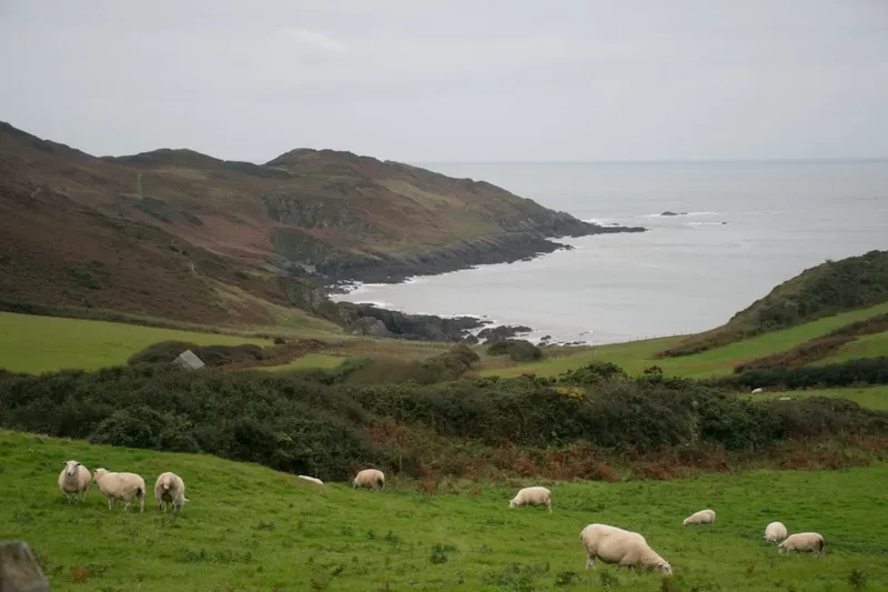
Livestock: You will walk through hundreds of fields containing sheep and cattle. During lambing season (spring), keep dogs on a short lead. If cattle (especially those with calves) approach you aggressively, do not run; move calmly away and, if necessary, let your dog off the lead so it can escape, as the cattle are usually interested in the dog, not you.
Side Trips and Points of Interest
Helvellyn via Striding Edge: For those with a head for heights and scrambling experience, the detour from the standard Patterdale route to summit Helvellyn is the ultimate Lake District "extra." Striding Edge is a narrow, rocky arête that requires steady nerves but offers the most exhilarating walking in England. The views from the summit plateau are unmatched.
Nine Standards Rigg: These nine giant stone cairns stand on the summit of Hartley Fell. Their origin is unknown—some say they were built to look like an army from a distance to deter invaders, others believe they are ancient boundary markers. Regardless of their history, they are the most evocative landmark on the trail.
The Wainstones: Located on the edge of the Cleveland Hills, these dramatic sandstone crags are a favourite for climbers and offer a fantastic spot for a lunch break with views stretching all the way to the North Sea.
Robin Hood's Bay Smuggling Alleys: Once you finish, spend an hour wandering the "snickets" and "wynds" of the lower village. Many of the houses were interconnected by secret passages used to move contraband away from the shoreline without being seen from the main street.
Leave No Trace

The Coast to Coast passes through fragile ecosystems and working landscapes. The cumulative impact of thousands of walkers can be significant. Following the "Countryside Code" is essential for the trail's survival.
Key Principles:
- Respect the Walls: Dry-stone walls are expensive and time-consuming to repair. Never climb over them; always use the provided stiles or gates. If a gate is closed, close it behind you; if it is propped open, leave it open.
- Protect the Peat: On the moors, stay on the main path. Peat bogs are vital carbon sinks; trampling them releases CO2 and destroys rare plant life.
- Litter: There are no bins on the trail. Pack out everything, including biodegradable items like banana skins and orange peel, which take years to decompose in the cold upland climate.
- Human Waste: Use public toilets in villages. If caught short, ensure you are at least 50 metres from any water source and bury waste deeply. Carry out all toilet paper and sanitary products.
- Dogs: Keep dogs under effective control. This is a trail through sheep country; a dog chasing sheep can be legally shot by a farmer.