Ciudad Perdida Trek - The Ancient Heart of the Sierra Nevada
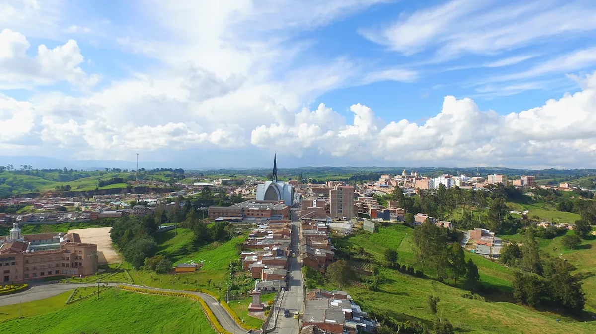
The Ciudad Perdida Trek, or the "Lost City" trek, is Colombia’s most iconic multi-day hiking adventure, leading deep into the lush, steam-filled jungles of the Sierra Nevada de Santa Marta. This 46-kilometre journey is more than a physical challenge; it is a pilgrimage through time to Teyuna, an ancient archaeological site built by the Tairona people approximately 650 years before Machu Picchu was even conceived. The route winds through the world’s highest coastal mountain range, crossing the turquoise waters of the Buritaca River and ascending over 1,200 ancient stone steps to reach the majestic circular terraces that once supported a thriving civilisation of thousands. Unlike many global treks that have been sanitised for tourism, the path to the Lost City remains raw, humid, and deeply connected to the indigenous communities—the Kogui, Wiwa, Arhuaco, and Kankuamo—who still consider this land sacred. It is a journey of sweat, steep gradients, and profound cultural immersion, where the reward is not just a view, but a connection to the "Elder Brothers" of the earth.
- Distance: 46.0 km out-and-back
- Duration: 4–6 days (4 days is the standard pace)
- Season: December to March (dry season is optimal; September is usually closed for indigenous cleansing)
- Accommodation: Basic jungle camps (hammocks or bunk beds with mosquito nets)
- Highest point: Approximately 1,200 metres at the Teyuna ruins
- Difficulty: Challenging (due to high humidity, heat, and steep "Colombian flats")
- Access: Mandatory guided tour starting from Santa Marta or Taganga
Overview
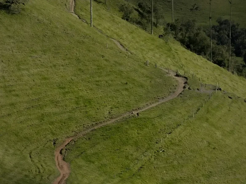
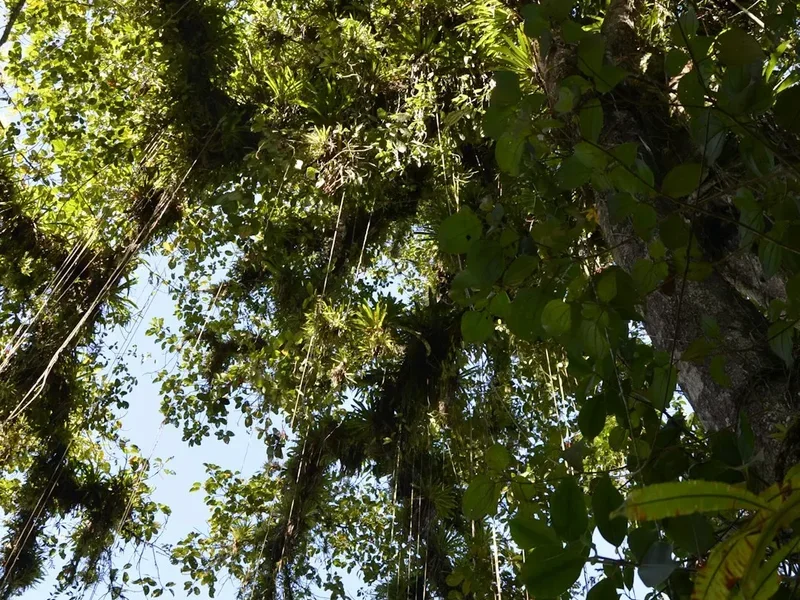
The Ciudad Perdida Trek is widely regarded as one of the most rewarding trekking experiences in South America, offering a stark contrast to the high-altitude, arid landscapes of the Andes. Located in the Sierra Nevada de Santa Marta, the trek traverses a unique ecosystem where tropical rainforest meets cloud forest. The trail type is an out-and-back route, meaning hikers follow the same primary path into the mountains and back out, though the perspective changes dramatically as the light shifts through the dense canopy. The terrain is defined by what locals affectionately call "Colombian flats"—a relentless series of steep ascents and descents that ensure you are rarely walking on level ground. Over the course of the journey, you will gain and lose significant elevation, testing your endurance in a climate where humidity often hovers near 90 per cent.
The experience is defined by its sensory intensity. The air is thick with the scent of damp earth and tropical blooms; the soundtrack is a constant cacophony of cicadas, howler monkeys, and the rushing Buritaca River. This river is the lifeblood of the trek, providing essential cooling opportunities in deep swimming holes that offer a brief respite from the sweltering heat. The trail passes through several indigenous villages, where you will see the white-clad Kogui and Wiwa people going about their daily lives, maintaining a spiritual and physical connection to the land that has remained largely unchanged for centuries. They view the Sierra Nevada as the "Heart of the World," and as a visitor, you are invited to walk through this heart with respect and mindfulness.
Reaching the Lost City itself is a crescendo of effort. After days of trekking through the jungle, you are faced with the final challenge: 1,200 narrow, moss-covered stone steps that climb steeply from the riverbank. Emerging from the trees onto the upper terraces of Teyuna is a moment of genuine awe. The site consists of over 160 terraces carved into the mountainside, connected by a network of tiled roads and small circular plazas. Because access is strictly limited to those who arrive on foot, the site retains an atmosphere of quiet mystery, free from the massive crowds found at other world heritage sites. It is a place of profound stillness, where the clouds often roll through the terraces, momentarily obscuring and then revealing the ancient stone foundations of a lost world.
Wakahi Guide
Detailed route notes, maps, logistics & tips for the Ciudad Perdida Trek (PDF).
History and Cultural Context
The history of Ciudad Perdida, or Teyuna, is a narrative of resilience and rediscovery. Built around 800 AD by the Tairona civilisation, the city was the political and spiritual centre of a vast network of villages in the Sierra Nevada. At its peak, it is estimated that between 2,000 and 8,000 people lived here, utilising sophisticated agricultural techniques and advanced engineering to manage the steep, rain-heavy terrain. The Tairona were master goldsmiths and potters, and their social structure was deeply integrated with their spiritual beliefs, which centred on the balance between humanity and nature. When the Spanish arrived in the 16th century, the Tairona resisted fiercely, but eventually, the combination of disease and warfare forced them to abandon their lowland cities and retreat higher into the mountains. Teyuna was swallowed by the jungle, remaining hidden from the outside world for nearly four centuries.
The "rediscovery" of the site occurred in 1972, not by archaeologists, but by "guaqueros" (tomb raiders). A group of local treasure hunters discovered the stone steps rising from the river and followed them to the ruins, where they found gold ornaments and fine pottery. For several years, the site was looted, and news of the "Green Hell" (as the looters called it) spread through the black market. It wasn't until 1975 that the Colombian government became aware of the site's significance. Archaeologists from the Colombian Institute of Anthropology and History (ICANH) arrived in 1976 to begin the painstaking process of clearing the jungle and restoring the terraces. They renamed the site Ciudad Perdida, though the indigenous descendants of the Tairona—the Kogui, Wiwa, Arhuaco, and Kankuamo—had always known of its existence, referring to it as Teyuna.
Today, the site is managed with a deep emphasis on indigenous sovereignty. The four tribes of the Sierra Nevada consider themselves the "Elder Brothers," tasked with protecting the earth's balance, while the rest of the world are the "Younger Brothers" who have lost their way. The trek provides a rare opportunity to learn about their philosophy of "Aluna"—the spiritual dimension where all things are created before they manifest in the physical world. Every September, the trail is closed to tourists to allow the indigenous communities to perform traditional ceremonies and "cleanse" the land of the spiritual footprint left by visitors. This ongoing cultural presence makes the Ciudad Perdida Trek one of the most authentic archaeological experiences in the world.
Want more background? Read extended notes on history and cultural context → Learn more
Seasonal Highlights and Weather Reality
The Sierra Nevada de Santa Marta experiences a tropical climate with two distinct seasons: the dry season and the wet season. Because of its proximity to the Caribbean coast and its extreme vertical rise, weather patterns can be unpredictable, and rain is possible at any time of year. However, choosing the right window can significantly impact the comfort and safety of your trek.
Dry Season (December to March): This is the most popular time to trek. The trails are firmer, river crossings are shallower and safer, and there is a higher probability of clear blue skies, which makes for spectacular photography at the ruins. However, the heat can be more intense during these months, and the trail is at its busiest. Even in the dry season, the humidity remains high, and afternoon tropical showers are still common.
Wet Season (April to November): During these months, the jungle is at its most vibrant and lush. The waterfalls are thunderous, and the Buritaca River runs deep and powerful. The primary challenge during the wet season is the mud; the trail can become extremely slippery and "tacky," making the steep climbs and descents much more physically demanding. River crossings may occasionally be delayed if water levels rise too high after a heavy downpour. October is typically the wettest month, with significant rainfall almost every afternoon.
The September Closure: It is critical to note that the Ciudad Perdida Trek usually closes for the entire month of September. This is a scheduled closure requested by the indigenous communities to allow for environmental recovery and spiritual rituals. If you are planning a trip to Colombia in September, you will need to look for alternative hikes, as no operators are permitted to run tours during this time.
Regardless of the season, temperatures generally range from 25°C to 35°C during the day, dropping to a comfortable 18°C to 22°C at night in the higher camps. The humidity is the constant factor—expect to be damp from either sweat or rain for the duration of the trek. Proper moisture-wicking clothing and dry bags for your gear are essential year-round.
Recommended Itinerary
4-Day Ciudad Perdida Itinerary
Day 1: Santa Marta to Camp 1 (Adán or Alfredo)
- Distance: 7.6 km
- Elevation gain: 450 m
- Time: 3–4 hours
- Morning departure from Santa Marta via 4x4 vehicle to the village of El Mamey (Machete Pelao)
- Lunch in El Mamey before starting the trek in the midday heat
- Initial steep climb on an exposed dirt road with little shade
- Transition into the jungle canopy as the path narrows
- Arrival at Camp 1, featuring a spectacular natural swimming hole in the river
- Evening briefing on Tairona culture and the days ahead
- First night sleeping in hammocks or bunks with mosquito nets
Day 2: Camp 1 to Camp 3 (Paraíso Teyuna)
- Distance: 14.7 km
- Elevation gain: 600 m
- Time: 7–8 hours
- Early 5:00 AM start to beat the heat of the day
- Long ascent through the valley of the Buritaca River
- Pass through the indigenous village of Mutanyi, home to the Kogui people
- Multiple river crossings—be prepared to remove boots or use water shoes
- Lunch at Camp 2 (Wiwa Camp) before the final push
- The "Uphill of Death"—a notorious steep section that tests endurance
- Arrival at Camp 3, the closest camp to the ruins, located deep in the canyon
- The sound of the river provides a constant backdrop for the night
Day 3: Camp 3 to Ciudad Perdida and back to Camp 2
- Distance: 8 km (plus exploration of the ruins)
- Elevation gain: 250 m (to the ruins)
- Time: 6–7 hours
- The highlight of the trek: crossing the river and ascending the 1,200 stone steps
- Arrival at the lower terraces of Teyuna just as the sun begins to hit the valley
- Guided tour of the archaeological site, including the ritual centres and the "Map Stone"
- Time for meditation and photography at the iconic upper terraces
- Descent back to Camp 3 for lunch
- Trek back down the valley, retracing steps to Camp 2 (Wiwa Camp)
- Evening cultural exchange with Wiwa guides, often including a demonstration of "Poporo" (traditional coca leaf usage)
Day 4: Camp 2 to El Mamey and Santa Marta
- Distance: 15.7 km
- Elevation gain: 350 m (various undulations)
- Time: 6–7 hours
- Final long day of trekking to return to civilisation
- Retracing the path through Mutanyi and back over the initial ridges
- The final descent into El Mamey is often the hottest part of the trek
- Celebratory lunch in El Mamey with the group
- 4x4 transport back to Santa Marta, arriving late afternoon
- The sense of accomplishment is immense as you leave the jungle behind
Important Notes:
- The trail is an out-and-back route; you will see the same scenery twice, but the direction of travel changes the difficulty of the climbs
- All river crossings should be handled with care; follow guide instructions during high water
- Hydration is critical—mules carry most food, but you must carry your own water
- The 1,200 steps to the ruins are narrow and can be very slippery when wet
- Respect indigenous privacy; always ask before taking photos of locals or their homes
- The itinerary can be extended to 5 or 6 days for a more relaxed pace with more time at the ruins
Planning and Bookings
Book Your Trip
Everything you need to plan your journey
Accommodation
Find places to stay near Santa Marta
Flights
Search flights to Santa Marta
Essential Preparation
The Ciudad Perdida Trek is not a hike you can do independently. By law and out of respect for the indigenous territories, you must book through one of the authorised tour operators based in Santa Marta. These operators coordinate the logistics, including 4x4 transport to the trailhead, all meals, accommodation in the jungle camps, and the mandatory permits. When choosing an operator, consider whether you want a Spanish-speaking guide or a translator; many companies now offer bilingual guides or provide a translator for the group.
Physical preparation is vital. While the total distance of 46 kilometres over four days might seem manageable on paper, the combination of steep gradients and extreme humidity makes it significantly more taxing than a similar distance in a temperate climate. Cardiovascular fitness is important, but leg strength for the constant "up and down" is what will serve you best. Santa Marta is the primary base for the trek. It is a vibrant coastal city with a range of accommodation from luxury hotels to backpacker hostels. Most hikers leave their main luggage at their hostel or the tour operator's office, taking only a small 20–30 litre daypack into the jungle.
Trail Accommodation
Accommodation on the Ciudad Perdida Trek is basic and communal, designed to have a minimal impact on the jungle environment. There are several "camps" (campamentos) along the route, which are shared by the various tour operators. You do not need to book these individually; your tour operator handles all arrangements.
Hut and Camp Facilities:
- Sleeping arrangements: Most camps offer either bunk beds or hammocks. All are equipped with mosquito nets, which are essential.
- Bedding: A thin blanket and pillow are usually provided, but many trekkers prefer to bring a lightweight silk liner for hygiene.
- Toilets and Showers: Camps have basic flushing toilets and cold-water showers. The cold water is actually a welcome relief from the jungle heat.
- Dining: Communal dining areas where hearty, high-calorie meals are served.
- Electricity: Very limited. Some camps have generators that run for a few hours in the evening, allowing for basic phone charging, but do not rely on this.
- Water: Large containers of treated or boiled water are provided at every camp for refilling your bottles.
What Camps Don't Provide:
- Towels or toiletries
- WiFi or mobile signal (you will be completely offline for the duration)
- Private rooms (all sleeping areas are open-air and shared)
- Hot water
- Laundry services (clothes will not dry in the humidity anyway)
Required Gear
- Hiking boots or trail shoes: Must have excellent grip for mud and wet stone. Ensure they are well broken-in.
- Water shoes or sandals: Essential for river crossings and for wearing around the camp in the evening.
- Daypack: 20–30 litres is sufficient. A rain cover is mandatory.
- Dry bags: Use these to waterproof everything inside your pack. A "waterproof" pack will still leak in a tropical downpour.
- Moisture-wicking clothing: Lightweight, quick-dry fabrics. Avoid cotton, which stays wet and becomes heavy.
- Long-sleeved shirt and trousers: For the evenings to protect against mosquitoes and "puri-puri" (sandflies).
- Socks: At least 3–4 pairs of high-quality trekking socks. Keeping feet dry is the best way to prevent blisters.
- Head torch: Essential for navigating the camps at night and for early morning starts.
What to Bring
- Insect repellent: High DEET concentration is recommended. The sandflies in the Sierra Nevada are notorious.
- Sun protection: SPF 50+ sunscreen, sunglasses, and a wide-brimmed hat for the exposed sections.
- Hydration system: 2–3 litre capacity (Bladder or bottles). You will sweat significantly.
- Personal first aid: Blister pads (Compeed), rehydration salts, ibuprofen, and any personal medications.
- Toiletries: Biodegradable soap, toothbrush, toothpaste, and a quick-dry travel towel.
- Hand sanitiser: Use frequently, especially before meals.
- Cash: Small denominations of Colombian Pesos (COP) for buying snacks, Gatorade, or beer at the camps.
- Power bank: To keep your camera or phone charged for photos.
- Swimwear: For the river swimming holes.
- Snacks: While meals are provided, personal favourites like energy bars or nuts can provide a much-needed boost.
Permits
Access to the Ciudad Perdida is strictly regulated by the Colombian Institute of Anthropology and History (ICANH) and the indigenous authorities of the Sierra Nevada. Unlike many other famous treks, there is no "permit lottery" for individuals to navigate. Instead, the permit system is integrated into the tour booking process. When you book with an authorised operator, a portion of your fee goes directly to the ICANH for site maintenance and to the indigenous and local peasant communities for land use and conservation.
Booking Process:
- You must book through one of the five or six authorised agencies (e.g., Expotur, Wiwa Tour, Magic Tour, Guias y Baquianos).
- Bookings can be made online in advance or in person in Santa Marta. During the peak season (December–January), it is advisable to book at least a few weeks ahead.
- The price is standardised across all agencies to prevent a "race to the bottom" that could compromise safety or fair wages for guides and porters.
- As of 2024, the cost for the 4-day trek is approximately 1,800,000 to 2,150,000 COP (roughly £350–£420 / $450–$540 USD).
What the Permit/Tour Fee Includes:
- Round-trip 4x4 transport from Santa Marta to El Mamey.
- All meals and snacks during the trek.
- Accommodation in the jungle camps.
- Entrance fee to the Ciudad Perdida archaeological park.
- A contribution to the indigenous and local communities.
- Guided services (usually a lead guide and a translator/assistant).
- Travel insurance for the duration of the trek.
Important Considerations: There are no "budget" ways to do this trek legally. Anyone offering a significantly cheaper price is likely operating without permits or fair labour practices. By paying the standardised fee, you ensure that the guides (many of whom are former guaqueros or indigenous locals) receive a fair wage and that the archaeological site is preserved for the future.
Other Activities in the Area
The region surrounding Santa Marta is one of the most diverse in the world. Consider these activities to complement your trek:
- Tayrona National Natural Park: Located just an hour from Santa Marta, this park features some of Colombia's most beautiful beaches, where the jungle meets the Caribbean Sea. Cabo San Juan is the most famous spot, offering iconic views and palm-fringed bays.
- Minca: A small village in the foothills of the Sierra Nevada, famous for its coffee and cacao farms, birdwatching, and cooler climate. It is the perfect place to relax for a few days after the trek.
- Palomino: A laid-back beach town further east, popular for "tubing" down the Palomino River, where you can float from the jungle all the way to the ocean.
- Taganga: A traditional fishing village turned scuba diving hub. It offers affordable PADI courses and a rugged, desert-like coastline.
- Santa Marta Historic Centre: Explore the oldest city in Colombia, visit the Cathedral, and dine in the vibrant Parque de los Novios.
- Quebrada Valencia: A series of beautiful waterfalls and natural pools located near the entrance to Tayrona Park, ideal for a half-day trip.
Safety and Conditions
Health and Physical Safety:
- Heat and Humidity: Heat exhaustion is the most common issue. Drink more water than you think you need and use rehydration salts. Listen to your body and take breaks in the shade.
- Water Safety: Never drink untreated water from the river. Only consume the water provided by your guides at the camps.
- Insects: While malaria is rare in this specific trekking corridor, Dengue and Zika are present in the region. Use high-DEET repellent and wear long sleeves in the evening.
- Vaccinations: Yellow Fever vaccination is often recommended for travel to the Sierra Nevada. Check current requirements before travelling.
Environmental Hazards:
- Flash Floods: During the wet season, the Buritaca River can rise rapidly. Always follow your guide's instructions regarding river crossings. If they say it is unsafe to cross, wait.
- Slippery Terrain: The 1,200 stone steps and the muddy descents are prime locations for ankle sprains. Use trekking poles if you have weak knees or balance concerns.
- Wildlife: Snakes and spiders exist in the jungle but are rarely seen on the well-trodden path. Do not stick your hands into dark crevices or hollow logs.
Security: The Sierra Nevada de Santa Marta has a complex history involving various armed groups. However, the trekking corridor to Ciudad Perdida has been safe and stable for over 15 years. The presence of the Colombian military at the ruins and the self-policing of the indigenous and local communities ensure a high level of security for tourists. Stick to the group and follow the established trail.
Travel insurance that covers "adventure activities" and "emergency evacuation" is mandatory for this trek. Ensure your policy specifically covers hiking up to 1,500 metres.
Side Trips and Points of Interest
The Indigenous Village of Mutanyi: On Day 2, the trail passes through Mutanyi, a significant Kogui settlement. While you cannot enter the private homes, walking through the village offers a glimpse into their traditional architecture—circular mud huts with thatched conical roofs. You will see children playing and women weaving "mochilas" (traditional bags). It is a powerful reminder that the Sierra Nevada is a living cultural landscape, not just an archaeological museum.
The Buritaca River Swimming Holes: Every camp is located near the river, and each has its own unique swimming spot. The water is crystal clear, cool, and incredibly refreshing after a day of trekking. Some spots have natural rock slides or deep pools for jumping. These moments of relaxation in the river are often the most cherished memories for trekkers.
The Map Stone (Piedra de la Memoria): Located within the Ciudad Perdida site, this large boulder is carved with intricate lines that archaeologists believe represent a map of the Sierra Nevada, showing the various paths and settlements that connected the Tairona world. It is a testament to the advanced geographical knowledge of the ancient inhabitants.
The Upper Terraces (The Iconic View): The most famous view of Ciudad Perdida is from the highest terraces, looking back down over the central plazas. This is where the "Cacique" (chief) and the "Mamo" (spiritual leader) would have lived. Standing here, surrounded by 360-degree views of the emerald mountains, you can truly feel the strategic and spiritual importance of the site's location.
Leave No Trace
The Sierra Nevada de Santa Marta is a fragile ecosystem and a sacred ancestral land. As "Younger Brothers," it is our responsibility to minimise our impact on this environment. The sheer volume of trekkers (thousands per year) means that even small actions can have a cumulative negative effect.
Your responsibility as a walker:
- Waste Management: Pack out everything you pack in. Do not leave even "organic" waste like banana peels or apple cores on the trail, as they are not native to this specific ecosystem and can attract pests.
- Respect the Water: Do not use soap or shampoo directly in the river. Even biodegradable products can harm aquatic life in concentrated amounts. Wash at the camp facilities provided.
- Stay on the Path: The jungle floor is a complex web of roots and small plants. Straying from the trail causes erosion and destroys habitat.
- Cultural Respect: The indigenous people are not "tourist attractions." Always ask for permission before taking a photograph of a person, especially children. Respect "off-limits" areas in the villages.
- No Graffiti: Never carve names or symbols into trees or the ancient stones of the ruins. This is an act of desecration.
- Silence is Golden: Keep noise levels down, especially near indigenous villages and in the ruins. The spiritual value of the site is found in its tranquility.
By following these principles, you help ensure that the "Heart of the World" remains healthy and that the indigenous communities continue to welcome visitors to their sacred Teyuna.