Chirripó Day Hike - Scaling the Roof of Costa Rica
The Chirripó Day Hike is arguably the most demanding single-day trekking challenge in Central America. Located within the Cordillera de Talamanca, Cerro Chirripó stands as the highest peak in Costa Rica, reaching an imposing 3,820 metres above sea level. While most hikers choose to tackle this ascent over two or three days, staying overnight at the Base Crestones lodge, the "Day Hike" is a formidable undertaking reserved for the physically elite and the mentally resilient. This 19.5-kilometre journey involves a staggering 2,100 metres of vertical elevation gain, transitioning from the lush premontane forests of San Gerardo de Rivas through ancient oak stands and cloud forests, finally emerging into the rare sub-alpine paramo ecosystem. On a clear day, the summit offers the legendary opportunity to see both the Pacific Ocean and the Caribbean Sea simultaneously—a geographical reward that few places on Earth can provide. This is not merely a walk; it is a vertical pilgrimage through the biological heart of the Talamanca Range, a UNESCO World Heritage site that protects some of the most pristine wilderness in the neotropics.
- Distance: 19.5 km (one-way to summit or high-intensity return to Base Crestones)
- Elevation Gain: 2,100 m
- Duration: 10–12 hours
- Difficulty: Very Challenging
- Best Time: December to April (dry season)
- Closest City: San Isidro de El General
- Trailhead: San Gerardo de Rivas
- Highest Point: 3,820 m (Cerro Chirripó summit)
Overview
The Chirripó Day Hike is a test of endurance that begins in the pre-dawn darkness of the Talamanca mountains. The trail, known as the Sendero Principal (Main Trail), is a relentless upward grind that begins at approximately 1,350 metres in the village of San Gerardo de Rivas. For the first several kilometres, hikers are enveloped in the dense, humid canopy of the premontane forest, where the sounds of the Chirripó River provide a constant acoustic backdrop. As the sun rises, the landscape undergoes a dramatic transformation. The humid forest gives way to the "Bosque de los Robles" (Oak Forest), where massive, centuries-old trees draped in epiphytes and mosses create a cathedral-like atmosphere. This section is often shrouded in mist, lending the trail a mystical, ethereal quality that defines the Costa Rican cloud forest experience.
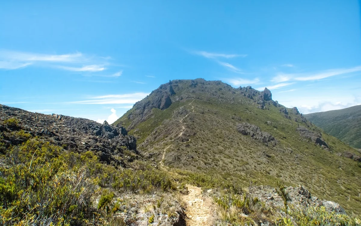
The physical toll of the hike becomes most apparent at the "Cuesta de los Arrepentidos" (The Slope of the Repentant), a notoriously steep section of the trail just before reaching the Base Crestones plateau. Here, the air begins to thin, and the vegetation stunts as you enter the paramo—a high-altitude shrubland found only in the tropics. The paramo of Chirripó is the northernmost example of this ecosystem in the Americas, featuring unique flora such as the "Chusquea" (dwarf bamboo) and various species of flowering shrubs that have adapted to the intense UV radiation and freezing night-time temperatures. Reaching the Base Crestones area at 3,400 metres is a milestone in itself, offering views of the iconic Los Crestones rock formations—jagged granite spires that have been designated a National Symbol of Costa Rica.
For those attempting the full day-hike experience, the final push to the summit involves navigating the Valle de los Conejos (Valley of the Rabbits) and a final, rocky scramble to the peak. The sheer scale of the landscape is humbling; looking down, you can see glacial lakes formed during the last ice age, such as Lago Chirripó, nestled in cirques carved by ancient ice. The descent is equally taxing, requiring careful footwork on steep, often slippery terrain. This hike is a masterclass in ecological transition, taking the walker through more life zones in a single day than one might experience in a cross-continental journey. It is a raw, unfiltered encounter with the power of the tropical mountains.
History and Cultural Context
The Talamanca Range has been a site of human significance for millennia. Long before the arrival of European explorers, the indigenous peoples of the region, including the Brunka (Boruca) and Cabécar, held Cerro Chirripó in deep spiritual reverence. The name "Chirripó" itself is derived from indigenous words meaning "Land of Eternal Waters," a reference to the numerous lakes and rivers that originate in these high-altitude catchments. For these cultures, the high peaks were the dwelling places of the gods, and the paramo was a sacred space that few dared to enter. Even today, the Cabécar people maintain a profound connection to the mountains, and their traditional knowledge of the local flora and fauna remains an integral part of the region's cultural fabric.
The first recorded non-indigenous ascent of Cerro Chirripó occurred in 1904, led by the priest Agustín Blessing Presinger. However, it wasn't until the mid-20th century that the mountain began to attract significant attention from scientists and mountaineers. In 1975, the Costa Rican government established Chirripó National Park, recognising the need to protect this unique high-altitude ecosystem from the threats of deforestation and cattle grazing. The park was later incorporated into the La Amistad International Park, a bi-national protected area shared with Panama, which was designated a UNESCO World Heritage site in 1983. This international recognition highlights the global importance of the Talamanca Range as a hotspot of biodiversity and endemism.
The history of the trail itself is one of constant adaptation. In 1976, a massive forest fire, sparked by human activity, devastated large swathes of the paramo and oak forests. The recovery has been slow, and the charred remains of ancient trees can still be seen in certain sections, serving as a stark reminder of the ecosystem's fragility. Today, the trail is managed by SINAC (Sistema Nacional de Áreas de Conservación) in collaboration with local community organisations in San Gerardo de Rivas. This partnership ensures that the benefits of tourism are shared with the local population while maintaining strict environmental standards to preserve the "Roof of Costa Rica" for future generations.
Want more background? Read extended notes on history and cultural context → Learn more
Seasonal Highlights and Weather Reality
Weather is the most critical factor in determining the success and safety of a Chirripó Day Hike. Costa Rica's climate is divided into two primary seasons: the dry season (Verano) and the green season (Invierno). The dry season, running from December to April, is the most popular time for the ascent. During these months, hikers can expect clear skies, particularly in the early morning, which provides the best chance of seeing both oceans from the summit. However, the dry season also brings the coldest temperatures; at the summit, temperatures can drop to -5 degrees Celsius at night, and frost is common in the paramo. Strong winds are also a feature of the dry season, which can increase the risk of wind chill and exhaustion.
The green season, from May to November, offers a different but equally beautiful experience. The landscape is vibrantly green, and the cloud forest is at its most atmospheric, with heavy mists and frequent rainfall. While the mornings may start clear, afternoon thunderstorms are almost a daily occurrence. These storms can be intense, with heavy rain and lightning, making the high ridges and the summit extremely dangerous. Hikers during this season must be prepared for wet conditions and should aim to be off the high plateau by midday. The trail can also become very muddy and slippery, significantly increasing the time required for both the ascent and descent.
Regardless of the season, weather on Chirripó is notoriously unpredictable. A clear morning can transform into a white-out within minutes as clouds roll up from the Caribbean lowlands. Temperature fluctuations are extreme; you may start the hike in 20-degree heat in San Gerardo and find yourself in near-freezing conditions at the summit just a few hours later. Proper layering and high-quality waterproof gear are non-negotiable requirements for anyone attempting this hike, regardless of the time of year. The "eternal waters" of Chirripó are a reality that every hiker must respect.
Recommended Itinerary
Chirripó Day Hike Itinerary
Early Morning: The Night Ascent
- 03:00: Start from the trailhead in San Gerardo de Rivas (1,350 m).
- Headlamps are essential as you navigate the lower forest sections in total darkness.
- The first 4 km involve a steady climb through premontane forest; listen for the nocturnal sounds of the jungle.
- Pass the "Termómetro" (The Thermometer) sign, marking your progress as the air begins to cool.
- Maintain a steady, sustainable pace to manage the 2,100 m of total gain.
Morning: The Cloud Forest and Llano Bonito
- 05:30: Reach Llano Bonito (7 km mark, 2,500 m).
- This is the only official rest stop with potable water and basic shelter before the lodge.
- Watch the sunrise over the Talamanca Range; the light filtering through the oak forest is spectacular.
- Continue through the "Bosque de los Robles" (Oak Forest), where the trail becomes steeper and more rugged.
- 08:00: Tackle the "Cuesta de los Arrepentidos" (The Slope of the Repentant). This is the most mentally taxing section of the climb.
Midday: The Paramo and Base Crestones
- 09:30: Arrive at the Base Crestones plateau (14.5 km mark, 3,400 m).
- The landscape opens up into the sub-alpine paramo; the jagged spires of Los Crestones dominate the skyline.
- Take a short break to refuel and assess weather conditions. If clouds are building rapidly, consider this your turnaround point.
- If conditions allow, push toward the summit via the Valle de los Conejos.
- 11:00: Reach the summit of Cerro Chirripó (3,820 m). On clear days, enjoy the dual-ocean view.
Afternoon: The Long Descent
- 11:30: Begin the descent. Do not linger too long at the summit, as afternoon storms are common.
- The descent is hard on the knees; use trekking poles to manage the impact.
- 13:30: Pass back through Llano Bonito for a final water refill.
- 16:00: Arrive back at the trailhead in San Gerardo de Rivas.
- Celebrate your achievement with a meal in the village; your body will require significant calorie replacement.
Important Notes:
- This itinerary is for highly fit individuals; adjust times based on your personal pace.
- Always check in with the park rangers at the trailhead before starting.
- Water is available at Llano Bonito and Base Crestones, but treatment is recommended.
- The "Day Hike" requires a specific permit from SINAC, distinct from overnight bookings.
- Cell signal is intermittent; do not rely on it for navigation or emergencies.
Planning and Bookings
Book Your Trip
Everything you need to plan your journey
Accommodation
Find places to stay near San Isidro de El General
Flights
Search flights to San Isidro de El General
Essential Preparation
Preparation for the Chirripó Day Hike begins months before you set foot on the trail. The physical requirements cannot be overstated; you are climbing the equivalent of two vertical kilometres in a single day at high altitude. Training should focus on sustained uphill hiking with a weighted pack, as well as cardiovascular conditioning. If possible, spend a few days at moderate altitude (such as in San Gerardo de Rivas or San José) before the hike to help your body begin the acclimatisation process.
Logistically, San Isidro de El General is the nearest major city and serves as the gateway to the region. From San Isidro, you must travel to the village of San Gerardo de Rivas, which sits at the base of the mountain. It is highly recommended to stay in San Gerardo for at least one night before your hike to ensure an early start. The village has several hostels and eco-lodges that cater specifically to hikers. You must also coordinate your transport to the trailhead, as the "Day Hike" starts well before public buses begin running.
Trail Accommodation
While this is a day hike, understanding the accommodation options is vital for safety and contingency planning. The primary facility on the mountain is the Base Crestones Lodge (officially the Albergue El Páramo), located at 3,400 metres. This lodge is managed by a private concessionaire and requires separate bookings from the park permit.
Lodge Facilities:
- Shared dormitory-style rooms with bunk beds and blankets.
- A cafeteria serving hot meals (breakfast, lunch, and dinner) for those with pre-purchased meal plans.
- Basic shared bathrooms with cold-water showers.
- A small shop selling snacks and basic supplies.
- Solar-powered lighting (limited hours) and no charging facilities for electronics.
Important for Day Hikers: Day hikers are generally not permitted to stay overnight at the lodge unless there is an emergency. However, the lodge serves as a critical safety point where you can seek shelter or medical assistance if needed. There are no other shelters or campsites allowed on the trail; wild camping is strictly prohibited within the national park to protect the fragile ecosystem.
Required Gear
- Footwear: High-quality hiking boots with excellent grip and ankle support. Ensure they are well broken-in to avoid blisters.
- Clothing: A moisture-wicking base layer, an insulating mid-layer (fleece or down), and a high-quality waterproof and windproof outer shell. Avoid cotton at all costs.
- Headlamp: Essential for the 03:00 start. Bring spare batteries or a power bank.
- Trekking Poles: Highly recommended to save your knees during the 2,100 m descent.
- Backpack: A 20–30 litre daypack with a rain cover.
- Navigation: A physical map or a reliable offline GPS app (like Gaia GPS or AllTrails).
- Emergency Kit: A basic first aid kit, an emergency space blanket, and a whistle.
What to Bring
- Hydration: At least 3 litres of water capacity. Bring a filtration system or purification tablets for refills at Llano Bonito.
- Nutrition: High-calorie, easily digestible snacks (energy bars, nuts, dried fruit) and a substantial lunch. You will burn 4,000–6,000 calories on this hike.
- Sun Protection: High-SPF sunscreen, lip balm with SPF, sunglasses, and a wide-brimmed hat. The UV radiation at 3,800 m is intense.
- Personal Items: Toilet paper and a small trowel (though using the facilities at Llano Bonito or the lodge is preferred), hand sanitiser, and any personal medications.
- Identification: A copy of your passport and your printed SINAC permit.
- Cash: Small denominations of Costa Rican Colones for local transport or emergency supplies in San Gerardo.
Permits
Securing a permit for Chirripó is a notorious challenge and requires navigating the SINAC (Sistema Nacional de Áreas de Conservación) online booking system. Permits for the "Day Hike" (known as "Pase de un Día") are limited and often sell out months in advance, particularly for the dry season. Unlike the overnight permits, which include lodge stays, the day permit only grants access to the trail for a specific 24-hour period.
Booking Process:
- Create an account on the official SINAC website (serviciosenlinea.sinac.go.cr).
- Select "Parque Nacional Chirripó" and choose the "Sector San Gerardo" entry point.
- Look for the "Caminata de un Día" option. If it is not visible, it may mean all slots for your dates are taken.
- Payment must be made via credit or debit card at the time of booking.
- Once booked, you will receive a confirmation email. You MUST print this or have a digital copy to present at the park office in San Gerardo de Rivas.
Check-in Requirements: All hikers must check in at the SINAC office in San Gerardo de Rivas the day before their hike. You will be required to show your identification and your permit. The rangers will provide you with a wristband or a physical permit that must be worn or carried at all times. Failure to check in the day before may result in your permit being cancelled. The office typically closes at 16:00, so plan your arrival in San Gerardo accordingly.
Costs: The permit fee for international visitors is approximately US$18 per day, while Costa Rican residents pay a significantly lower rate (around 4,000 Colones). These fees contribute directly to the maintenance of the trail and the protection of the national park.
Other Activities in the Area
San Gerardo de Rivas and the surrounding Chirripó valley offer several excellent activities for those looking to recover or explore further:
- Cloudbridge Nature Reserve: A private reforestation project adjacent to the national park. It offers beautiful trails, spectacular waterfalls, and excellent birdwatching (including the Resplendent Quetzal) without the permit requirements of Chirripó.
- Gevi Hot Springs: Located just outside San Gerardo, these natural thermal pools are the perfect way to soothe aching muscles after the 2,100 m descent.
- Butterfly Garden (Mariposario): A small, well-run garden in the village where you can learn about the local lepidoptera and the ecology of the valley.
- Coffee Tours: The region around San Isidro de El General is famous for its high-altitude coffee. Several local farms offer tours that explain the process from bean to cup.
- Quesería Chirripó: Visit the local cheese factory to sample artisanal cheeses made from the milk of cows grazing on the mountain slopes.
Safety and Conditions
Altitude Sickness (Soroche): While 3,820 metres is not "extreme" altitude, it is high enough to cause Acute Mountain Sickness (AMS). Symptoms include headache, nausea, dizziness, and fatigue. Because the Chirripó Day Hike involves a very rapid ascent, the risk of AMS is higher than on the multi-day trek. If you experience severe symptoms, the only cure is descent. Do not push toward the summit if you are feeling unwell.
Hypothermia: Even in the tropics, hypothermia is a genuine risk on Chirripó. The combination of sweat-soaked clothing, high winds, and plummeting temperatures can lead to a dangerous drop in body temperature. Always carry a dry base layer and a windproof shell. If you get wet, change into dry clothes as soon as possible.
Trail Conditions: The trail is well-marked but can be extremely rugged. Exposed roots, loose rocks, and deep mud are common. Ankle injuries are the most frequent medical issue on the mountain. Take your time on the descent, as fatigue often leads to careless footwork. During the rainy season, be aware of the risk of landslides in steep sections.
Lightning: The high ridges and the summit are extremely exposed. If you hear thunder or see dark clouds building, descend immediately. Do not wait for the rain to start. Lightning strikes on the high peaks are a documented hazard.
Emergency Contacts: Ensure someone knows your itinerary and expected return time. There is no dedicated mountain rescue team in the area; any evacuation is organised by park rangers and the Red Cross, which can take many hours. Carrying a satellite communication device (like a Garmin inReach) is highly recommended for solo hikers.
Side Trips and Points of Interest
Los Crestones: These iconic rock formations are the result of millions of years of erosion on volcanic and metamorphic rock. They are a symbol of Costa Rican national pride and offer some of the most dramatic photography opportunities in the park. While the main trail passes near them, a short detour allows you to stand at their base and appreciate their scale.
Valle de los Conejos: A high-altitude glacial valley located between Base Crestones and the summit. It is named for the rabbits that were once common here. The valley is a prime example of the paramo ecosystem and offers a sense of immense solitude and silence.
Cerro Ventisqueros: The second-highest peak in the park (3,812 m). The trail to Ventisqueros branches off near the lodge and offers a slightly different perspective of the range. It is often less crowded than the main summit and provides incredible views of the "Sabana de los Leones" (Lion's Savannah).
Glacial Lakes: From the summit of Chirripó, you can look down into the Moraine Valley to see several glacial lakes, including Lago Chirripó and Lago Ditkevi. These are the highest lakes in Central America and are remnants of the glaciers that covered these peaks during the Pleistocene epoch.
Leave No Trace
The Chirripó ecosystem is one of the most fragile in the world. The plants in the paramo grow incredibly slowly due to the cold temperatures and thin soil; a single footstep off the trail can destroy decades of growth. As a visitor to this UNESCO World Heritage site, you have a profound responsibility to minimise your impact.
Core Principles for Chirripó:
- Pack it in, pack it out: This includes all organic waste like banana peels and orange pips, which do not decompose quickly at high altitudes and can disrupt the local fauna's diet.
- Stay on the trail: The Sendero Principal is clearly defined. Do not create "social trails" or shortcuts, which lead to severe erosion.
- Respect the water: Do not wash in the lakes or streams. Even biodegradable soap can harm the delicate aquatic life in these high-altitude catchments.
- No fires: Fire is the greatest threat to the paramo. The 1976 fire proved how devastating a single spark can be. Cooking is only permitted in the designated area at the lodge.
- Wildlife: Observe animals from a distance. Do not feed the birds or the occasional coati you may encounter near the lodge.