Chilkoot Trail - The World's Longest Museum
The Chilkoot Trail is a legendary 53-kilometre journey that transcends simple hiking, offering a profound immersion into one of the most dramatic chapters of human history. Stretching from the ghost town of Dyea, Alaska, in the United States, to the abandoned railway terminus of Bennett, British Columbia, in Canada, this point-to-point route serves as a living monument to the 1897–1898 Klondike Gold Rush. Often referred to as "the world's longest museum," the trail is littered with the rusted relics of a century ago—discarded stoves, rotting leather boots, and collapsed tramway towers—all preserved by the sub-arctic climate. It is a path of immense physical challenge and staggering ecological diversity, climbing from the lush, temperate rainforests of the Pacific coast, over the formidable granite ramparts of the Chilkoot Pass, and into the high-altitude alpine tundra and boreal forests of the Canadian interior. To walk the Chilkoot is to follow in the footsteps of the 30,000 "stampeders" who hauled tonnes of supplies over these mountains in a desperate bid for gold, and the Tlingit people who utilised this route for centuries as a vital trade link between the coast and the interior.
- Distance: 53.0 km point-to-point
- Duration: 3–5 days
- Season: Late June to early September (snow-free window)
- Campsites: 9 designated backcountry campgrounds (reservations mandatory)
- Highest point: Chilkoot Pass (1,067 m)
- Daily capacity: Strictly limited by permit (approximately 50 people per day)
- Direction: South to north (Dyea to Bennett) is the standard and recommended direction
Overview
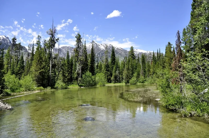
The Chilkoot Trail is a masterclass in environmental transition and historical storytelling. Unlike many wilderness treks that focus solely on natural beauty, the Chilkoot is defined by the tension between the raw power of the landscape and the desperate ambition of the humans who tried to conquer it. The journey begins at sea level in the Taiya River valley, where the air is thick with the scent of Sitka spruce and the ground is a carpet of emerald moss. As you progress inland, the trail ascends through three distinct ecological zones, each presenting its own set of challenges and rewards. The coastal rainforest gives way to sub-alpine scrub, which eventually disappears entirely as you reach the "Scales" and prepare for the final, brutal ascent of the Chilkoot Pass—a 45-degree scramble over massive granite boulders that remains the psychological and physical crux of the entire trek.
Once over the pass, the landscape undergoes a radical transformation. You cross the international border from the United States into Canada, leaving behind the damp, maritime influence of the Pacific and entering the rain shadow of the Coast Mountains. Here, the terrain opens up into a vast, high-altitude plateau of turquoise lakes, stunted sub-arctic flora, and expansive granite slabs. The final stages of the trail follow the shores of Lake Lindeman and Lake Bennett, where the stampeders once paused to build the boats that would carry them down the Yukon River toward the goldfields of Dawson City. The silence of the modern trail is a stark contrast to the industrial cacophony of 1898, yet the presence of the past is inescapable. Every rusted tin can and every weathered timber tells a story of endurance, failure, and the indomitable human spirit.
This is a challenging trek that requires a high level of physical fitness and backcountry competence. The weather is notoriously fickle; even in the height of summer, the Chilkoot Pass can be shrouded in freezing fog, lashed by torrential rain, or dusted with fresh snow. The trail surface varies from soft forest duff and muddy river flats to jagged rock fields and slippery snow patches. However, for those who are prepared, the Chilkoot offers a sense of accomplishment that few other trails can match. It is not merely a walk through the woods; it is a pilgrimage through history, a test of character, and a rare opportunity to experience the wild, untamed heart of the North American frontier.
History and Cultural Context
The history of the Chilkoot Trail is layered, beginning long before the first gold seeker set foot in the Taiya Valley. For centuries, the route was a strictly controlled trade path owned and managed by the Chilkoot Tlingit (Klukwan) people. They acted as the essential middlemen between the coastal Tlingit and the interior Athabaskan peoples (Tagish and Tutshone), trading coastal resources like eulachon oil (candlefish oil) for interior furs and copper. The Tlingit fiercely guarded the pass, preventing European explorers and traders from using the route until the late 19th century. Their intimate knowledge of the terrain and their ability to carry immense loads made them the primary packers during the early years of exploration and the subsequent gold rush.
The world changed forever in August 1896 when gold was discovered in Rabbit Creek (later renamed Bonanza Creek) in the Klondike region of the Yukon Territory. By 1897, the "Klondike Fever" had gripped the globe. Tens of thousands of people from all walks of life—doctors, labourers, mayors, and teachers—descended on the ports of Skagway and Dyea. The Chilkoot Trail became one of the two primary overland routes to the goldfields (the other being the White Pass). However, the North-West Mounted Police, stationed at the summit, enforced a strict "one tonne of goods" rule. To prevent mass starvation in the remote Yukon, every stampeder was required to bring a year's supply of food and equipment—roughly 900 to 1,000 kilograms. Because no pack animal could navigate the steep boulders of the Chilkoot Pass, men and women had to carry these supplies on their backs, making 30 to 40 return trips over the summit. This Herculean effort created the iconic image of the "Golden Stairs"—a continuous line of men carved into the snow, slowly ascending the pass in a human chain.
The boom was short-lived. By 1899, the White Pass & Yukon Route railway was completed, rendering the arduous Chilkoot Trail obsolete almost overnight. The towns of Dyea and Bennett were abandoned, left to the elements. In the 1960s and 70s, the governments of Canada and the United States recognised the historical significance of the route, eventually establishing the Klondike Gold Rush International Historical Park. Today, the trail is co-managed by Parks Canada and the US National Park Service, ensuring that the relics remain in situ and the stories of the Tlingit and the stampeders continue to be told to new generations of adventurers.
Want more background? Read extended notes on history and cultural context → Learn more
Seasonal Highlights and Weather Reality
The Chilkoot Trail is only accessible for a brief window each year, typically from late June to early September. Outside of this period, the trail is reclaimed by the sub-arctic winter, with deep snowpacks, extreme cold, and significant avalanche danger making it the domain of only the most experienced winter mountaineers. Even within the summer season, the weather is the primary factor determining the difficulty and safety of the trek.
Late June to Mid-July: This is the "early season." While the lower elevations are lush and green, the Chilkoot Pass and the high-altitude sections in Canada are often still covered in significant snow. Hikers must be prepared for "post-holing" (sinking into soft snow) and navigating steep, slippery slopes. The benefit of this period is the nearly 24-hour daylight of the northern summer and the spectacular sight of alpine wildflowers beginning to bloom at the edges of the retreating snow. However, river levels can be high due to snowmelt, making some crossings more challenging.
Late July to Mid-August: This is generally considered the peak season. The snow on the pass has usually melted back to a few manageable patches, and the trail is at its driest. Temperatures in the valleys can reach a pleasant 20°C, though the summit remains cool. This is also the peak time for biting insects—mosquitoes and blackflies can be intense, particularly in the forested sections and near the lakes. Hikers should be prepared with head nets and strong repellent.
Late August to Early September: The "late season" brings the first hints of autumn. The tundra turns brilliant shades of red and gold, and the biting insects begin to disappear. The weather becomes more unstable, with a higher frequency of autumn storms blowing in from the Gulf of Alaska. Night-time temperatures can drop below freezing, and fresh snow on the pass (known as "termination dust") is a real possibility. The days shorten significantly, and the northern lights (Aurora Borealis) may occasionally be visible on clear nights.
Regardless of the month, hikers must respect the "Chilkoot Weather." It is common to experience four seasons in a single day. The coastal side is notoriously wet, receiving heavy rainfall even when the interior is sunny. The pass acts as a weather divide; it is frequently shrouded in "the soup"—a thick, disorienting fog that makes navigation difficult and increases the risk of hypothermia.
Recommended Itinerary
5-Day Chilkoot Trail Itinerary
Day 1: Dyea Trailhead to Canyon City
- Distance: 12.5 km
- Elevation gain: 150 m
- Time: 4–6 hours
- Start at the Dyea trailhead (15 km from Skagway)
- The trail begins with a flat section through coastal forest before climbing "Saintly Hill"
- Follow the Taiya River through dense rainforest of Sitka spruce and hemlock
- Pass the ruins of the "Dyea-Klondike Transportation Company" powerhouse
- Arrive at Canyon City Campground, located near the ruins of a once-booming town of 1,500 people
- Explore the Canyon City ruins, including the famous large rusted boiler
- This day is a relatively gentle introduction, allowing hikers to adjust to their pack weight
Day 2: Canyon City to Sheep Camp
- Distance: 10.5 km
- Elevation gain: 250 m
- Time: 4–6 hours
- The trail becomes more rugged, with frequent ups and downs over glacial moraines
- Pass through "Pleasant Camp," a small site often used as a lunch spot
- The forest begins to thin, offering glimpses of the surrounding hanging glaciers and granite peaks
- Cross several suspension bridges over rushing glacial streams
- Arrive at Sheep Camp, the largest and most popular campground on the US side
- Sheep Camp is the final staging area before the pass; rangers usually give a mandatory weather and trail briefing here every evening
- Rest early, as the following day is the most demanding of the trek
Day 3: Sheep Camp to Happy Camp (The Summit Day)
- Distance: 12 km
- Elevation gain: 785 m gain, 300 m descent
- Time: 8–12 hours
- Start at dawn (4:00 AM – 6:00 AM) to ensure enough time to cross the pass safely
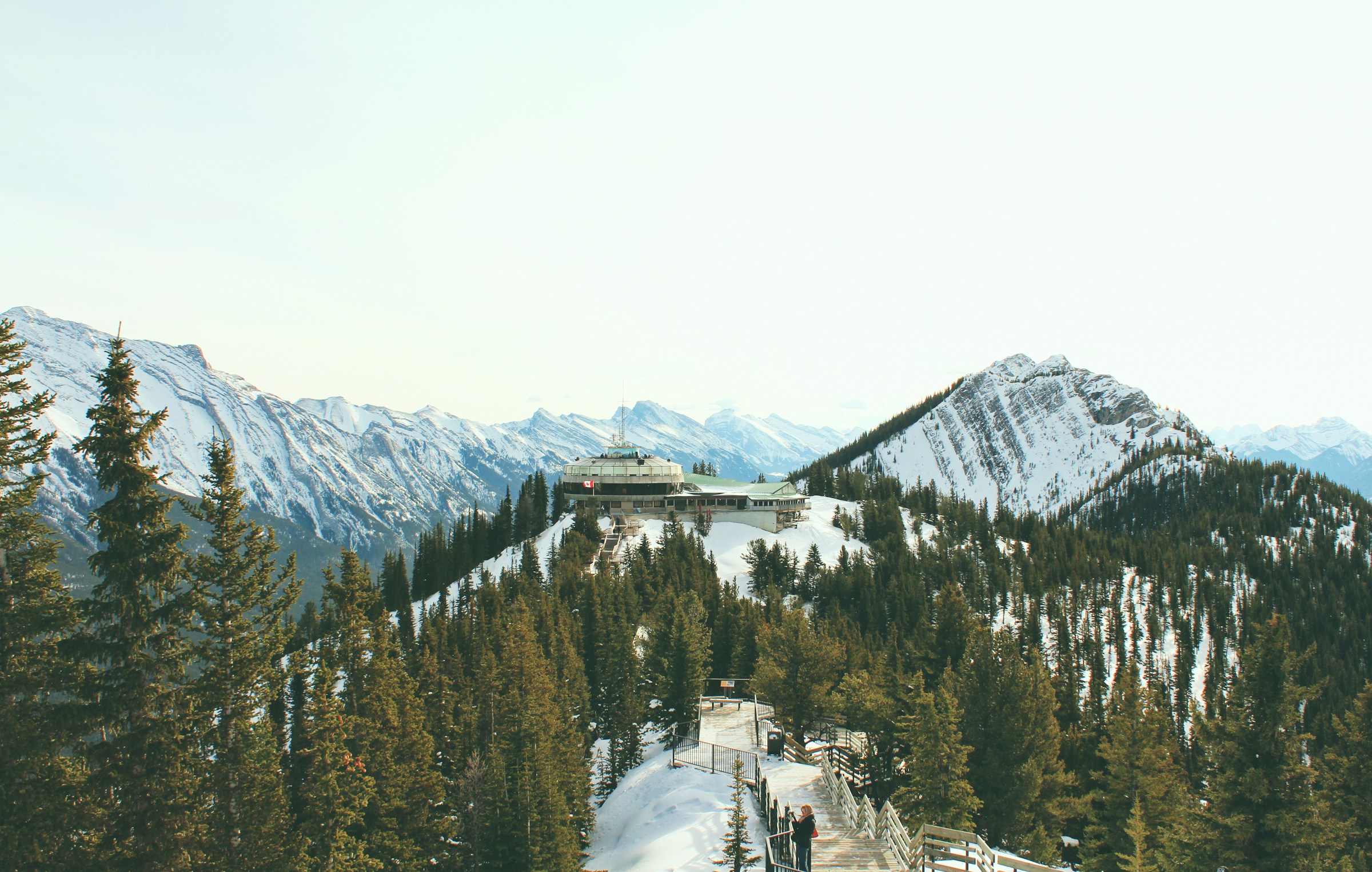
- Climb above the treeline to "The Scales," where stampeders re-weighed their loads
- The "Golden Stairs": A 300-metre vertical scramble over massive boulders to the summit
- Cross the international border at the summit (1,067 m) and check in with the Parks Canada warden
- Descend through the "Stone Crib" and navigate across the high-altitude snowfields (if present)
- The landscape shifts to sub-arctic tundra with stunning views of Crater Lake
- Arrive at Happy Camp, the only campground located in the true alpine zone
- This is the most physically and mentally taxing day, requiring stamina and careful footwork
Day 4: Happy Camp to Lindeman City
- Distance: 14.5 km
- Elevation: 200 m descent, various undulating terrain
- Time: 5–7 hours
- Walk through the "Long Lake" section, featuring expansive granite slabs and turquoise water
- The trail follows the eastern shore of Deep Lake and Long Lake
- Vegetation returns in the form of stunted sub-alpine fir and krummholz
- Pass through the "Moose Flats" area, a prime spot for birdwatching
- Arrive at Lindeman City, situated on the shores of beautiful Lake Lindeman
- Visit the Parks Canada tent museum, which displays artefacts and photos from the Lindeman encampment
- The descent is gradual but the rocky terrain can be hard on the knees
Day 5: Lindeman City to Bennett
- Distance: 11 km
- Elevation: 150 m descent
- Time: 4–5 hours
- The trail climbs over a ridge between Lake Lindeman and Lake Bennett
- Pass through the "Bare Loon Lake" campground, a scenic spot overlooking a small lake
- The final descent leads through a sandy pine forest toward the Bennett railway station
- Arrive at Bennett, the end of the trail
- Explore the historic St. Andrew’s Presbyterian Church, the only building remaining from the gold rush
- Board the White Pass & Yukon Route train or a pre-arranged floatplane for the return journey
- Celebrate the completion of a historic odyssey
Important Notes:
- Permits are mandatory and must be carried at all times
- The trail is point-to-point; transport from Bennett must be booked in advance
- Bear canisters are mandatory for all food and scented items
- Water must be treated (boiling, filtering, or chemical treatment)
- The Chilkoot Pass is a serious alpine environment; do not attempt in poor visibility without GPS
- Respect all historical artefacts—it is illegal to move or remove them
Planning and Bookings
Book Your Trip
Everything you need to plan your journey
Accommodation
Find places to stay near Skagway
Flights
Search flights to Skagway
Essential Preparation
The Chilkoot Trail requires meticulous planning, often beginning six months to a year in advance. Because the trail crosses an international border, all hikers must possess a valid passport and any necessary visas for both the United States and Canada. You will technically "clear customs" at the summit, though the process is informal; however, you must submit your customs information to the relevant authorities before starting.
Physical fitness is paramount. This is not a flat walk; it involves significant elevation gain, technical rock scrambling, and potentially long days on your feet with a heavy pack (15–25 kg). Training should include hill climbing with a weighted pack and exercises to strengthen the core and ankles. Logistically, Skagway, Alaska, serves as the primary base. It is accessible via the Alaska Marine Highway (ferry), by road via the Klondike Highway, or by small aircraft from Juneau. Most hikers spend at least one night in Skagway to collect permits, purchase fuel, and arrange transport to the Dyea trailhead.
Trail Accommodation
Accommodation on the Chilkoot Trail consists exclusively of designated backcountry campgrounds. There are no indoor sleeping huts or lodges along the route. Each campground is equipped with specific facilities to manage human impact and protect the environment.
Campground Facilities:
- Designated tent platforms or cleared dirt sites
- Composting or pit toilets (toilet paper is usually provided, but bring a backup)
- Bear-proof food storage lockers (mandatory use)
- Grey-water disposal pits for cooking water
- Warming shelters: Most camps have a communal wooden shelter with a wood-burning stove. These are for cooking, drying gear, and socialising—sleeping in shelters is strictly prohibited except in extreme medical emergencies.
- Water sources: Nearby creeks or lakes (all water must be treated)
What is NOT Provided:
- Bedding, mattresses, or tents
- Cooking stoves or fuel
- Food or rubbish collection (Pack it in, pack it out)
- Electricity or mobile phone service
Booking Requirements:
- Reservations are mandatory for the peak season (June–September)
- Bookings typically open in early spring (check the Parks Canada website for the exact date)
- You must specify which campground you will stay in each night; you cannot "wing it"
- Cost: Approximately CAD$15–$20 per person per night, plus a reservation fee and the Chilkoot Trail permit fee (approx. CAD$60–$70)
Required Gear
- Footwear: High-quality, waterproof hiking boots with excellent ankle support. The "Golden Stairs" and rocky Canadian sections require boots with a stiff sole and good grip. Ensure they are thoroughly broken in.
- Rain Gear: A heavy-duty waterproof jacket and overtrousers (Gore-Tex or similar). The coastal side of the pass can experience relentless rain for days.
- Backpack: 55–75 litre capacity with a high-quality suspension system and a waterproof rain cover.
- Shelter: A lightweight, 3-season backpacking tent capable of withstanding high winds and heavy rain.
- Sleeping System: A sleeping bag rated to at least -5°C (even in summer) and an insulated sleeping pad.
- Navigation: A detailed topographic map, a compass, and a GPS device with offline maps. The trail is generally well-marked, but fog on the pass can make finding the route difficult.
- Bear Safety: An approved bear-resistant food canister (if not using lockers) and bear spray (carried in an accessible holster, not inside the pack).
What to Bring
- Food: High-calorie, lightweight dehydrated meals. Bring an extra day's worth of food in case of weather delays on the pass.
- Water Treatment: A reliable filter (hollow fibre or ceramic) or purification drops/tablets. Glacial silt can clog some filters, so a pre-filter is useful.
- Stove and Fuel: A lightweight backpacking stove (isobutane/propane canisters or liquid fuel). Fuel cannot be taken on planes, so purchase it in Skagway.
- Clothing Layers: Moisture-wicking base layers (merino wool is best), an insulating mid-layer (fleece or down), and a warm hat and gloves for the summit. Avoid cotton at all costs.
- First Aid: A comprehensive kit including blister care (moleskin/Leukotape), anti-inflammatories, and any personal medications.
- Sun Protection: Sunglasses (essential for snow glare on the pass), sunscreen, and a wide-brimmed hat.
- Insect Protection: A head net and repellent with a high DEET or Picaridin concentration.
- Personal Items: Biodegradable soap, a small trowel (for emergencies between camps), and a lightweight camp towel.
Permits
The Chilkoot Trail is a highly regulated environment to preserve its historical integrity and wilderness character. A "Chilkoot Trail Classic Hike Permit" is required for all overnight users during the peak season. This permit covers both the US and Canadian portions of the trail.
How to Obtain a Permit:
- Permits are managed through the Parks Canada reservation system.
- Reservations usually open in late March or April for the upcoming summer season. Demand is extremely high, particularly for July and August dates, so it is recommended to be online the moment the system opens.
- You must provide your full itinerary (which camp you stay in each night) at the time of booking.
- Once reserved, you must pick up your physical permit in person at the Trail Centre in Skagway, Alaska, before you start your hike. You will be required to watch a safety orientation video.
Customs and Border Requirements:
- Because you are hiking from the US into Canada, you must comply with all border crossing regulations.
- Hikers must possess a valid passport.
- You are required to submit an ArriveCAN declaration (if applicable) and potentially contact Canada Border Services Agency (CBSA) before departure.
- The Parks Canada warden at the summit or at Lindeman City may ask to see your permit and identification.
Day Use: If you are only hiking a portion of the trail and returning to Dyea on the same day, a permit is generally not required, but you should still check in at the Trail Centre for safety reasons.
Other Activities in the Area
The region surrounding the Chilkoot Trail is steeped in history and natural beauty. Consider these activities to round out your trip:
- White Pass & Yukon Route Railway: Often called the "Scenic Railway of the World," this narrow-gauge railway is a marvel of engineering. Even if you don't use it to return from Bennett, a day trip from Skagway provides incredible views of the White Pass and the rugged mountains.
- Skagway Historic District: Spend a day exploring the boardwalks of Skagway. Visit the Mascot Saloon, the Arctic Brotherhood Hall, and the various museums managed by the National Park Service.
- Dyea Ghost Town and Slide Cemetery: Before starting your hike, visit the ruins of Dyea and the sobering Slide Cemetery, where many victims of the 1898 Palm Sunday Avalanche are buried.
- Flightseeing: Take a helicopter or floatplane tour from Skagway to see the massive glaciers of the Juneau Icefield and get a bird's-eye view of the Chilkoot Pass.
- Haines, Alaska: A short ferry ride from Skagway, Haines offers excellent wildlife viewing (including bald eagles), hiking, and a more laid-back, local atmosphere.
- Yukon Suspension Bridge: Located on the Klondike Highway, this offers a thrilling view of the Tutshi River rapids and informative displays about the region's geology.
Safety and Conditions
Bear Safety: The Chilkoot Trail is prime habitat for both Black Bears and Grizzly (Brown) Bears. Encounters are common. To stay safe: always store food, rubbish, and scented items (toothpaste, sunscreen) in the provided bear lockers or an approved canister. Never cook inside your tent. Carry bear spray in an accessible location and know how to use it. Make noise while hiking, especially in dense brush or near rushing water, to avoid surprising a bear.
Hypothermia: This is the most significant medical risk on the trail. The combination of cold temperatures, high winds, and wet clothing can lead to hypothermia even in mid-summer. Always carry high-quality rain gear and warm layers. Recognise the "umbles" (stumbling, mumbling, fumbling) in yourself and your companions. If someone becomes hypothermic, stop immediately, get them into dry clothes, and provide warm fluids and shelter.
The Chilkoot Pass: The ascent from the Scales to the summit is the most dangerous part of the trail. It involves scrambling over large, potentially unstable boulders. In wet or icy conditions, these rocks are incredibly slippery. If the "soup" (fog) rolls in, visibility can drop to a few metres. Follow the markers (painted rocks and poles) carefully. If you lose the trail in the fog, stay put until it clears or use a GPS to reorient yourself. Do not attempt to "glissade" (slide) down snowfields unless you are experienced and the run-out is safe.
Water Safety: Giardia and other waterborne pathogens are present in the environment. All water from streams and lakes must be filtered, boiled for at least one minute, or chemically treated. Be cautious during river crossings; glacial rivers can be fast, deep, and extremely cold. Use the provided bridges whenever possible.
Emergency Communication: There is no mobile phone coverage on the trail. Parks Canada and NPS wardens are stationed at various points (Sheep Camp, the Summit, Lindeman City) and have radio communication. However, carrying a satellite messenger (like a Garmin inReach or Zoleo) is highly recommended for summoning help in a life-threatening emergency.
Side Trips and Points of Interest
The Scales and the Golden Stairs: Located just below the summit on the US side, this area is a treasure trove of history. Look for the rusted remains of the various tramway systems that were built to haul freight over the pass. The "Golden Stairs" themselves are a massive boulder field; as you climb, imagine doing so with 40 kilograms on your back in the middle of winter.
Canyon City Ruins: A short side trail from the Canyon City campground leads to the site of the original town. You can see the remains of a large boiler, building foundations, and various household items half-buried in the forest floor. It is a haunting reminder of how quickly these boomtowns rose and fell.
Lindeman City Museum: Parks Canada maintains a small but excellent "tent museum" at Lindeman City. It contains fascinating photographs of the thousands of boats that were built here in 1898 and artefacts recovered from the lake shore. The wardens are often available to share stories and answer questions about the area's history.
St. Andrew’s Presbyterian Church: Located at the very end of the trail in Bennett, this weathered wooden structure is the last standing building from the gold rush era in the town. It sits on a hill overlooking Lake Bennett, providing a perfect spot for reflection at the end of your journey.
Bare Loon Lake: This small, picturesque lake between Lindeman and Bennett is a beautiful spot for a swim on a rare warm day. The water is clearer and slightly warmer than the larger glacial lakes, and the surrounding granite slabs are perfect for sunbathing.
Leave No Trace
The Chilkoot Trail is a fragile sub-arctic environment and a protected historical site. Every hiker has a responsibility to minimise their impact to ensure the trail remains pristine for future generations. The "Leave No Trace" principles are strictly enforced by both US and Canadian rangers.
Key Principles for the Chilkoot:
- Respect Historical Artefacts: This is the most important rule on the Chilkoot. It is a federal offence in both countries to move, disturb, or remove any historical object, no matter how small. A rusted nail or a piece of broken glass is part of the archaeological record. Leave everything exactly where you find it.
- Dispose of Waste Properly: Use the provided toilets at all campgrounds. If you must go between camps, dig a "cathole" at least 15 centimetres deep and 60 metres from water. Pack out all toilet paper. All rubbish, including food scraps and organic waste (like orange peels), must be packed out.
- Stay on the Trail: The alpine tundra is extremely slow to recover from trampling. Stay on the established path or on durable surfaces like rock and gravel.
- Store Food Securely: Use the bear lockers at every camp. Never leave food unattended, even for a minute. This prevents bears from becoming "habituated" to human food, which usually results in the bear having to be destroyed.
- Minimise Campfire Impact: Fires are only permitted in the provided stoves in the warming shelters. Do not build new fire rings. Use only dead and downed wood if provided, but preferably use your backpacking stove for all cooking.
By following these principles, you honour the history of the trail and protect the wildlife that calls this rugged landscape home.