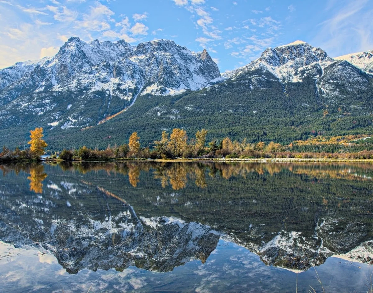
Chilcotin Mountains Traverse - The Serengeti of the North
The Chilcotin Mountains Traverse is Canada’s premier wilderness expedition—an 80.0 km journey through the rugged heart of the South Chilcotin Mountains Provincial Park and the Spruce Lake Protected Area in British Columbia. This challenging 6 to 8-day trek offers an unparalleled immersion into a landscape defined by vast alpine meadows, volcanic peaks of vibrant ochre and violet, and crystal-clear turquoise lakes. Unlike the more manicured trails of the Canadian Rockies, the Chilcotin Traverse is a raw, multi-use backcountry experience where hikers share the path with mountain bikers and horse-packers, yet the sheer scale of the terrain ensures a profound sense of isolation. Starting from the remote trailheads near Gold Bridge or Tyax Lake, the route climbs through diverse ecosystems—from dense Douglas fir forests to high-altitude tundra—crossing dramatic mountain passes that offer 360-degree views of the Coast Range. This is a journey for the self-sufficient adventurer, demanding high levels of fitness, navigation skills, and a deep respect for the grizzly bear territory that defines this wild corner of the world.
- Distance: 80.0 km point-to-point
- Duration: 6–8 days
- Season: July to September (snow-free window; wildflowers peak in July, larches turn gold in September)
- Accommodation: Wilderness campsites (Spruce Lake, Hummingbird Lake, Lorna Lake, Bear Creek)
- Elevation Gain: 3,000 m total ascent
- Highest Point: Deer Pass (2,340 m)
- Difficulty: Challenging (remote, significant elevation, grizzly bear habitat)
- Closest City: Williams Lake or Lillooet, British Columbia
Overview
The Chilcotin Mountains Traverse is often referred to as the "Serengeti of the North" due to its incredible biodiversity and the vast, rolling alpine grasslands that resemble the African savannah, albeit at 2,000 metres above sea level. The route is a masterclass in geological diversity. As you travel from south to north, the landscape shifts from the lush, rain-shadow forests of the Gun Creek valley to the stark, multi-coloured volcanic ridges of the Big Creek drainage. The trail is not a single, fixed path but a network of interconnected routes that allow for various configurations, though the classic traverse from Tyax Lake to the Relay Creek trailhead remains the gold standard for those seeking the full experience.
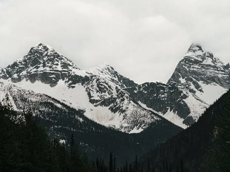
The terrain is demanding but immensely rewarding. Walkers can expect long days of steady climbing, followed by exhilarating descents into hanging valleys where ice-cold streams provide the only source of water. The highlight for many is the crossing of Deer Pass, the highest point on the traverse. From this vantage point, the scale of the South Chilcotin Mountains Provincial Park becomes clear: a sea of peaks stretching toward the horizon, with no roads, no permanent structures, and no signs of modern civilisation. The weather here is notoriously fickle; even in the height of summer, a clear morning can transform into a snow squall by mid-afternoon, requiring hikers to be prepared for all four seasons in a single day.
What sets the Chilcotin Traverse apart from other Canadian long-distance walks is its history as a multi-use corridor. You are as likely to see a group of horse-packers carrying supplies to a remote camp as you are to see a mountain biker tackling the technical descents. This shared heritage creates a unique backcountry culture based on mutual respect and a shared love for the "Chilcotin High." The solitude found here is genuine; once you move beyond the popular Spruce Lake area, you may go days without seeing another human soul, leaving you alone with the whistling marmots, soaring golden eagles, and the ever-present possibility of a grizzly bear encounter.
History and Cultural Context
The South Chilcotin Mountains have been the ancestral home of the Tsilhqot’in (Chilcotin) and St’at’imc First Nations for millennia. These mountains were not merely a backdrop but a vital source of sustenance, providing hunting grounds for mountain goats, deer, and marmots, as well as rich picking grounds for huckleberries and medicinal plants. The trails used by modern hikers often follow the ancient grease trails—trade routes used to transport eulachon oil from the coast to the interior. The cultural significance of this land is profound, and hikers are encouraged to travel with an awareness of the deep spiritual connection the Indigenous peoples maintain with these peaks and valleys.
In the late 19th and early 20th centuries, the region saw a surge of European interest during the gold rush era. Prospectors combed the creeks—Gun Creek, Tyaughton Creek, and Relay Creek—searching for the elusive mother lode. While no massive gold deposits were found on the scale of the Klondike, the era left behind a legacy of old mining cabins and names that reflect the optimism of the time. Following the miners came the outfitters and guides. The Chilcotin became world-renowned for its big-game hunting and rugged horse-packing expeditions. Legendary guides like Charlie Miller and the Taylor family established the first permanent camps and helped map the intricate trail systems that form the basis of the traverse today.
The transition from a resource-extraction and hunting landscape to a protected wilderness began in the late 20th century. After decades of advocacy by conservationists and local residents who recognised the unique ecological value of the area, the South Chilcotin Mountains Provincial Park was formally established in 2010. This designation, along with the adjacent Spruce Lake Protected Area, ensures that the "Serengeti of the North" remains a sanctuary for wildlife and a premier destination for non-motorised wilderness recreation. Today, the park is managed with a focus on maintaining the delicate balance between its multi-use heritage and the preservation of its pristine alpine ecosystems.
Want more background? Read extended notes on history and cultural context → Learn more
Seasonal Highlights and Weather Reality
The window for completing the Chilcotin Mountains Traverse is relatively short, typically spanning from early July to mid-September. Outside of this period, snowpack makes the high passes impassable for those without advanced winter mountaineering skills and equipment. Even within the summer season, the weather is a dominant force that dictates the daily rhythm of the trek.
July: This is the month of the great alpine bloom. The meadows of Taylor Basin and Deer Pass become a riot of colour, with Indian paintbrush, lupine, and western anemone carpeting the hillsides. However, July is also the peak of "bug season." Mosquitoes and blackflies can be relentless in the lower valleys and near lake shores, making a head net and strong repellent essential. Snow patches may still linger on the north faces of the passes, requiring careful footwork.
August: Generally the most stable month for weather, August offers the best chance for clear skies and dry trails. The bugs begin to subside as the nights grow cooler. This is the prime time for wildlife viewing, as grizzly bears move into the high meadows to forage on berries and marmots. Water levels in the creeks begin to drop, making river crossings easier, though some smaller streams may dry up entirely.
September: For many, this is the finest time to be in the Chilcotins. The sub-alpine larches turn a brilliant gold, and the dwarf birch and willow in the valleys shift to deep reds and oranges. The air is crisp, and the first dustings of "termination dust" (early snow) often appear on the highest peaks. However, the days are significantly shorter, and temperatures can plummet well below freezing at night. By late September, the risk of a major autumn storm increases, potentially ending the hiking season abruptly.
Regardless of the month, hikers must be prepared for the "Chilcotin Factor"—sudden, violent thunderstorms that can roll over the ridges with little warning. Lightning is a genuine hazard on the exposed passes, and hypothermia is a risk even in mid-summer if a hiker is caught in a cold rain without proper layers.
Recommended Itinerary
7-Day Chilcotin Traverse Itinerary
Day 1: Jewel Creek Trailhead to Spruce Lake
- Distance: 14 km
- Elevation gain: 450 m
- Time: 5–6 hours
- Start at the Jewel Creek trailhead (accessible via Gold Bridge)
- Follow the Gun Creek trail through open Douglas fir forest and grassy slopes
- Gradual climb with views of the Gun Creek valley
- Arrive at Spruce Lake, a stunning turquoise lake surrounded by peaks
- Set up camp at the designated Spruce Lake wilderness site
- Excellent fishing for rainbow trout in the evening
Day 2: Spruce Lake to Hummingbird Lake
- Distance: 12 km
- Elevation gain: 350 m
- Time: 4–5 hours
- Depart Spruce Lake heading north towards the Tyaughton Creek drainage
- Pass through the "Open Heart" area, known for its wide-open meadows
- Cross several small creeks (usually easy rock-hops in mid-summer)
- Arrive at Hummingbird Lake, a smaller, more secluded alpine tarn
- This is a shorter day, allowing for exploration of the surrounding ridges
Day 3: Hummingbird Lake to Deer Pass Base
- Distance: 15 km
- Elevation gain: 600 m
- Time: 6–7 hours
- Descend into the Tyaughton Creek valley before beginning the long climb towards Deer Pass
- The trail becomes more rugged and less defined in sections
- Pass through prime grizzly bear habitat; make plenty of noise
- Camp at a suitable wilderness spot near the base of the final climb to Deer Pass
- Ensure all food is stored in bear-resistant canisters or hung properly
Day 4: Deer Pass Base to Bear Creek via Deer Pass
- Distance: 12 km
- Elevation: 800 m gain to pass, 700 m descent
- Time: 7–9 hours
- The most challenging and spectacular day of the traverse
- Steep, unrelenting climb to the summit of Deer Pass (2,340 m)
- 360-degree views of the South Chilcotin and Big Creek ranges
- Descend into the Bear Creek drainage via steep scree slopes and alpine meadows
- Arrive at the Bear Creek campsite, a remote and wild location
- Watch for mountain goats on the cliffs above the pass
Day 5: Bear Creek to Lorna Lake
- Distance: 14 km
- Elevation gain: 400 m
- Time: 6–7 hours
- Follow the Bear Creek trail northwards
- The landscape becomes more volcanic, with red and purple rock formations
- Cross the Big Creek divide, entering the Big Creek Provincial Park area
- Arrive at Lorna Lake, the northern jewel of the park
- Lorna Lake is often used as a base for floatplane drop-offs or pick-ups
Day 6: Lorna Lake to Elbow Pass Base
- Distance: 10 km
- Elevation gain: 500 m
- Time: 5–6 hours
- Climb out of the Lorna Lake basin towards Elbow Pass
- The trail traverses high alpine tundra with minimal vegetation
- Spectacular views back towards the heart of the Chilcotins
- Camp near the headwaters of the Relay Creek drainage
- This area is very exposed; ensure your tent is well-staked against high winds
Day 7: Elbow Pass to Relay Creek Trailhead
- Distance: 13 km
- Elevation: 800 m descent
- Time: 5–6 hours
- Final descent through the Relay Creek valley
- The trail follows the creek, passing through old mining exploration areas
- The terrain transitions back into thicker forest as you lose elevation
- Finish at the Relay Creek trailhead
- Requires a pre-arranged shuttle or a long walk back to the main road
Important Notes:
- This is a wilderness route; trail markings are minimal and navigation skills are required
- Campsites are primitive; there are no huts or permanent shelters on this route
- Water must be treated or filtered from all sources
- Grizzly bear safety is paramount; carry bear spray and know how to use it
- The itinerary can be shortened by using a floatplane to Lorna Lake or Spruce Lake
Planning and Bookings
Book Your Trip
Everything you need to plan your journey
Accommodation
Find places to stay near Williams Lake
Flights
Search flights to Williams Lake
Essential Preparation
The Chilcotin Mountains Traverse requires meticulous planning due to its remoteness and the lack of services. Your journey begins long before you hit the trail, starting with the logistics of reaching the trailhead. The nearest major centre is Williams Lake, but most hikers access the park via the small community of Gold Bridge. The drive from Vancouver takes approximately 5 to 7 hours, involving winding mountain roads and significant sections of unpaved logging roads. A high-clearance 4x4 vehicle is strongly recommended, as road conditions can deteriorate rapidly after rain.
Fitness is a critical factor. You will be carrying a full multi-day pack (typically 15–20 kg) over rugged terrain with significant elevation changes. Training should include weighted hikes and cardiovascular conditioning. Furthermore, you must be proficient in backcountry navigation. While some sections of the trail are well-worn, others—especially over the high passes—can be obscured by snow or scree. Carrying a GPS with offline maps, a topographic map, and a compass is non-negotiable.
Trail Accommodation
Accommodation on the Chilcotin Traverse consists entirely of wilderness camping. There are no public huts or lodges along the main traverse route, although some private lodges (such as Tyax Lodge) exist at the periphery of the park.
Campsite Facilities:
- Designated sites (Spruce Lake, Lorna Lake) may have basic pit toilets and bear-proof food caches
- Most other sites are "random camping" locations with no facilities
- No treated water; all water must be sourced from lakes or streams
- No fires are permitted in the alpine; a lightweight backpacking stove is required
- Campsites are first-come, first-served
What is NOT Provided:
- Shelter of any kind (you must bring a high-quality 3-season tent)
- Bedding or mattresses
- Cooking equipment or fuel
- Waste management (you must pack out all rubbish)
Booking Requirements:
- As of the current season, no formal "booking" is required for the wilderness campsites, but you must register your trip with BC Parks
- Backcountry camping fees apply (currently $10 per person, per night) and should be paid online via the BC Parks website before departure
- If using a floatplane service (Tyax Air), bookings should be made months in advance as they fill up quickly during the summer season
Required Gear
- Sturdy hiking boots - waterproof with excellent ankle support for scree slopes
- Backpacking pack - 60–75L capacity with a high-quality suspension system
- 3-Season tent - must be capable of withstanding high winds and heavy rain/snow
- Sleeping bag - rated to at least -5°C (alpine nights are cold even in August)
- Sleeping pad - insulated (R-value 3 or higher) to protect against ground chill
- Navigation kit - GPS, topographic maps, compass, and spare batteries
- Bear spray - carried in an accessible holster (not inside the pack)
- Satellite messenger - (e.g., Garmin inReach) essential for emergency communication in a region with zero mobile signal
- Multi-tool and gear repair kit - for fixing tents, stoves, or packs in the field
What to Bring
- Food for 8 days - high-calorie, lightweight dehydrated meals plus extra emergency rations
- Water filtration system - pump filter or gravity bag (UV filters may struggle with glacial silt)
- Bear-resistant food canister - (e.g., BearVault) required for areas without food caches
- Stove and fuel - canister or liquid fuel stove (ensure you have enough for the entire trip)
- Clothing layers - merino wool base layers, fleece mid-layer, down/synthetic puffy jacket
- Rain gear - high-quality waterproof jacket and trousers (Gore-Tex or similar)
- Sun protection - SPF 50 sunscreen, polarised sunglasses, and a wide-brimmed hat
- First aid kit - including blister care, antiseptic, and personal medications
- Toiletries - biodegradable soap, trowel for waste, and "wag bags" for high-alpine areas
- Head torch - with extra batteries (though summer days are long, the forest is dark)
Permits
While the Chilcotin Mountains Traverse does not currently operate on a strict "limited entry" permit system like the West Coast Trail, there are still regulatory requirements that every hiker must follow to ensure the sustainability of the park and the safety of its visitors.
Backcountry Registration: All overnight visitors to South Chilcotin Mountains Provincial Park and Big Creek Provincial Park are required to purchase a backcountry camping permit. This can be done through the BC Parks "Discover Camping" portal. The permit is not for a specific site but covers your stay within the park boundaries. You should print a copy of your permit and keep it in a waterproof bag attached to your pack.
Fees:
- Adults (16+): $10.00 per person, per night
- Children (6–15): $5.00 per person, per night
- Fees are used for trail maintenance and the provision of basic facilities like bear caches and pit toilets at popular lakes
Group Size: To minimise environmental impact and reduce the risk of negative wildlife encounters, BC Parks recommends a maximum group size of 8 people. Larger groups require special permission and are generally discouraged in the sensitive alpine tundra zones.
Floatplane Access: If you choose to fly into Lorna Lake or Spruce Lake to begin your traverse, you must coordinate with Tyax Air. They are the primary operator in the region. Flying in saves two days of uphill hiking but requires careful weight management, as floatplanes have strict baggage limits (typically 11–14 kg per person including your pack).
Other Activities in the Area
The South Chilcotins are a hub for outdoor adventure beyond just hiking. Consider these options to round out your trip:
- Mountain Biking: The park is world-famous for its "backcountry flow" trails. Many hikers choose to return with a bike to experience the long, winding descents of Gun Creek or Taylor Pass.
- Floatplane Sightseeing: Even if you aren't using a plane for transport, a sightseeing flight from Tyax Lake offers a breathtaking perspective on the glaciers and hidden valleys of the Coast Range.
- Fishing: Spruce Lake and Lorna Lake are renowned for their vibrant populations of rainbow trout. A lightweight collapsible rod is a worthy addition to your pack.
- Horseback Trekking: Several local outfitters offer guided multi-day horse-packing trips, providing a traditional way to see the mountains without the heavy pack.
- Photography: The unique mineral composition of the mountains (reds, oranges, and purples) combined with the golden larches in September makes this a bucket-list destination for landscape photographers.
Safety and Conditions
Grizzly Bear Safety: The South Chilcotin Mountains are home to a significant and healthy population of grizzly bears (Ursus arctos). This is their kingdom, and you are a guest. Safety is managed through prevention: always travel in groups, make constant noise (calling out "Hey bear!" especially near rushing water or thick brush), and maintain a scrupulously clean camp. Never cook near your tent, and always store food, toiletries, and "smellies" in bear-proof containers or caches. Carry bear spray in a holster on your hip or chest—not in your pack—and know how to deploy it in seconds.
Remote Terrain and Communication: There is no mobile phone coverage anywhere on the traverse. In the event of an injury or emergency, you are on your own until help can be summoned. A satellite communication device (like an inReach or Zoleo) is essential. Be aware that Search and Rescue (SAR) response times can be measured in days, not hours, depending on weather and helicopter availability. Carry a comprehensive first aid kit and have at least one member of your party trained in wilderness first aid.
Water and Weather: While water is generally abundant, it must be treated. Giardia and Cryptosporidium are present in the backcountry. Furthermore, glacial silt can quickly clog standard filters; a pre-filter or a gravity system is recommended. Weather can change from 25°C and sunny to 0°C and snowing in a matter of hours. Hypothermia is the leading cause of SAR calls in the region. Always carry full waterproofs and an insulating layer, even on a day that starts perfectly clear.
River Crossings: Depending on the time of year and recent rainfall, some creek crossings (particularly Tyaughton Creek and Big Creek) can be challenging. Always unclip your pack's waist belt before crossing, wear shoes to protect your feet, and use trekking poles for stability. If a crossing looks too deep or fast, wait until the following morning when water levels are typically lower due to reduced glacial melt overnight.
Side Trips and Points of Interest
Warner Pass: A spectacular detour from the Lorna Lake area, Warner Pass offers a gateway into the even more remote Big Creek drainage. The pass is flanked by towering peaks and provides a sense of "end of the world" solitude that is hard to find elsewhere. It is a steep climb but offers some of the best geological displays in the park.
Mount Sheba: For those with extra energy at Spruce Lake, a day hike up the slopes of Mount Sheba provides a bird's-eye view of the entire Gun Creek system. The mountain is famous for its crumbling volcanic ridges and the vibrant wild flowers that cling to its lower slopes. The summit is a scramble and should only be attempted by those comfortable with loose rock.
The "Graveyard" Valley: Located near the northern end of the traverse, this valley earned its name from the numerous bleached bones of elk and deer found there—likely the result of heavy winters or predator activity. It is a hauntingly beautiful, wide-bottomed valley that feels like a scene from a Western movie.
Taylor Basin: If you have an extra day, a side trip into Taylor Basin (near the start of the trek) is highly recommended. The basin is a lush alpine bowl that holds snow late into the season and is a frequent haunt for mountain goats and marmots. The old mining remains in the area add a touch of historical intrigue to the natural beauty.
Leave No Trace
The alpine environment of the Chilcotin Mountains is extremely fragile. At 2,000 metres, the growing season is measured in weeks, and a single footprint off-trail can damage mosses and lichens that take decades to recover. As the popularity of this route grows, our collective responsibility to protect it becomes even more vital.
Core Principles for the Chilcotins:
- Travel on Durable Surfaces: Stay on the established trail whenever possible. In the high alpine where no trail exists, spread out your group to avoid creating new "social trails."
- Dispose of Waste Properly: Pack out everything. This includes orange peels, tea bags, and cigarette butts. For human waste, use pit toilets where available. In the high alpine, use a "wag bag" to pack out waste, or dig a cathole at least 20 cm deep in organic soil at least 70 metres from water.
- Leave What You Find: Do not collect wildflowers, rocks, or historical artefacts from old mining sites. Take photos instead.
- Minimise Campfire Impacts: Fires are discouraged and often banned during the summer due to wildfire risk. Use a stove for all cooking.
- Respect Wildlife: Observe bears, goats, and deer from a distance. Never feed wildlife, as a "fed bear is a dead bear."