
Chembra Peak Trek - A Verdant Ascent in Wayanad
The Chembra Peak Trek is a captivating day walk located in the Wayanad district of Kerala, India. Standing at an elevation of 2,100 metres (2,100 m) above sea level, Chembra Peak is the highest point in the Western Ghats of Wayanad, offering breathtaking panoramic views of the surrounding lush green hills, valleys, and tea plantations. The trek is renowned for its moderate difficulty, accessible trailhead, and the iconic heart-shaped lake nestled midway up the mountain, a natural wonder that draws visitors from far and wide. This trek provides an immersive experience into the rich biodiversity and serene landscapes of the region, making it a popular destination for nature enthusiasts, trekkers, and photographers.
- Distance: 9.0 km one-way
- Elevation gain: 800 m
- Duration: 5-6 hours round trip
- Season: September to May (avoid monsoon season)
- Difficulty: Moderate
- Closest City: Kalpetta
- Trailhead Access: Nearest airport: Calicut International Airport (CCJ). From Calicut, take a taxi or bus to Kalpetta (approx. 3 hours). From Kalpetta, hire a jeep or taxi to Chembra Peak base (approx. 1 hour). Road conditions are generally good but can be narrow and winding in places. Parking available at the base. Permits are mandatory and can be obtained at the forest office near the trailhead. Registration is required.
Overview
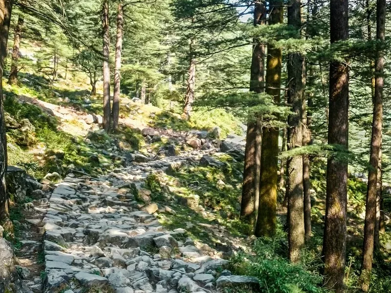
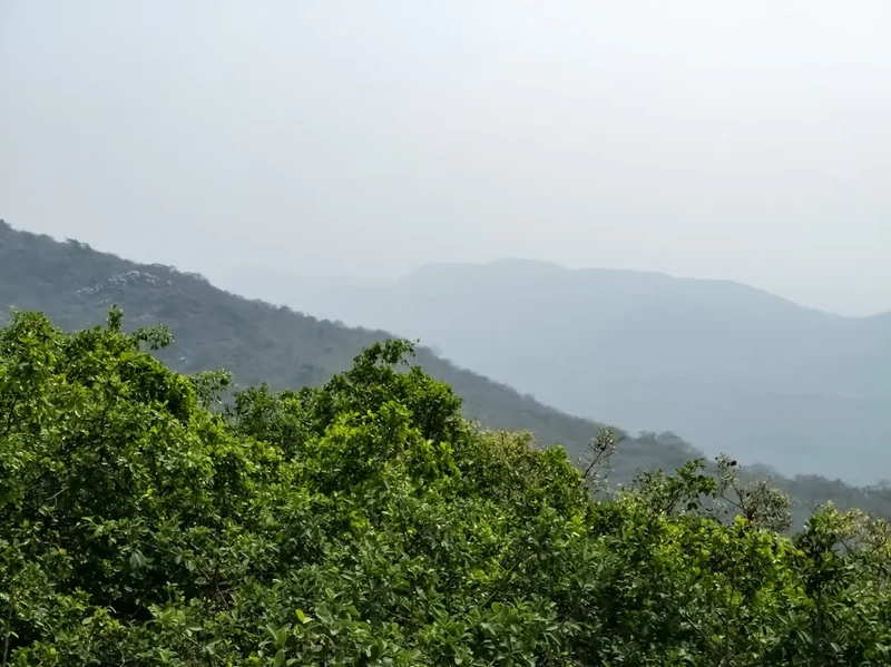
The Chembra Peak Trek is a journey through a landscape that epitomises the natural beauty of the Western Ghats. The trail begins at the foothills, gradually ascending through dense forests teeming with diverse flora and fauna. As you climb higher, the vegetation transitions, offering glimpses of rolling hills carpeted with tea estates and spice plantations. The air is fresh, carrying the scent of earth and exotic spices, a testament to Wayanad's rich agricultural heritage.
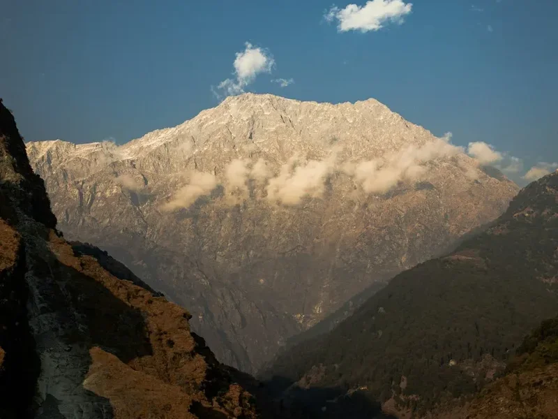
The most distinctive feature of the trek is the heart-shaped lake, a natural freshwater body situated about two-thirds of the way up the peak. This picturesque spot is a popular resting point and a photographer's delight. Legend has it that the lake has never dried up, even during the harshest summers, adding to its mystique. The trek continues beyond the lake, leading to the summit of Chembra Peak. From the top, the vista is simply spectacular. On a clear day, you can see as far as the neighbouring districts and even the Arabian Sea in the distance. The vast expanse of green, punctuated by mist-laden valleys and distant mountain ranges, creates a truly awe-inspiring panorama.
The trek is managed by the Kerala Forest Department and the local tourism promotion council, ensuring that the environment is protected and visitors have a safe and enjoyable experience. The moderate difficulty level makes it accessible to most fitness levels, though the significant elevation gain requires a reasonable level of stamina. The trek is best undertaken during the post-monsoon and winter months when the weather is pleasant, and the landscape is at its most vibrant.
History and Cultural Context
Chembra Peak, like many natural landmarks in India, is steeped in local folklore and has been a significant feature of the Wayanad landscape for centuries. While there isn't a documented history of ancient civilisations or major historical events directly tied to the peak itself, its presence has always been integral to the lives of the indigenous communities and early settlers of the region. The area is known for its rich tribal heritage, with communities like the Adiyans, Kurichians, and Paniyas inhabiting the surrounding forests and hills. These communities have traditionally lived in harmony with nature, relying on the forests for sustenance and resources.
The peak's name, "Chembra," is believed to have origins in the local dialects, possibly referring to a type of medicinal herb or a geographical feature. The heart-shaped lake, a major attraction today, is often the subject of local legends. One popular tale speaks of a mythical couple whose eternal love is symbolised by the lake's enduring form. Another story suggests it was a place of meditation for ancient ascetics.
In more recent times, Chembra Peak gained prominence as a trekking destination with the rise of adventure tourism in Kerala. The Kerala Forest Department and the District Tourism Promotion Council (DTPC) recognised its potential and developed it into a managed trekking route. Efforts have been made to preserve its natural beauty and ensure sustainable tourism practices. The trek offers not just a physical challenge but also an opportunity to connect with the natural and cultural heritage of Wayanad, a region that has historically been a melting pot of various tribal cultures and agricultural traditions.
Seasonal Highlights and Weather Reality
The best time to undertake the Chembra Peak Trek is from September to May. During these months, the weather is generally pleasant, making the ascent comfortable and the views clear.
Post-Monsoon (September to November): This period marks the end of the heavy monsoon rains. The landscape is at its most vibrant, with lush greenery and numerous small waterfalls cascading down the hillsides. The air is fresh, and the weather is typically mild, with temperatures ranging from 20°C to 25°C. Visibility is usually excellent, offering stunning panoramic views from the summit. The heart-shaped lake is full and picturesque.
Winter (December to February): This is considered the peak season for trekking in Wayanad. The weather is cool and dry, with daytime temperatures averaging between 15°C and 20°C. Nights can be cooler, sometimes dropping to 10°C. The skies are generally clear, providing unobstructed views. This is an ideal time for photography and enjoying the serene beauty of the mountains. Sandflies can be present, though less aggressive than in warmer months.
Summer (March to May): While still a viable time to trek, the temperatures begin to rise, with daytime highs reaching up to 30°C. The landscape can appear drier, though the heart-shaped lake remains a constant attraction. Mornings and late afternoons are the most comfortable times to trek. The chances of encountering mist are higher during this period, adding a dramatic element to the scenery.
Monsoon Season (June to August): This period is generally not recommended for trekking Chembra Peak. Heavy rainfall can make the trails slippery and dangerous. Visibility is severely reduced due to fog and mist, obscuring the panoramic views. The risk of landslides and flash floods increases, making the trek unsafe. The forest department often closes the trail during heavy monsoon periods for safety reasons.
Recommended Itinerary
Chembra Peak Day Trek Itinerary
Early Morning (Approx. 7:00 AM - 8:00 AM): Arrival at Trailhead & Registration
- Arrive at the base of Chembra Peak, near the forest check post.
- Complete the mandatory registration process at the forest office. This typically involves providing identification and paying the entry fee.
- Briefing by forest guides regarding the trail, safety precautions, and rules.
- Final preparations: hydrate, apply sunscreen, and ensure you have all necessary gear.
Morning (Approx. 8:00 AM - 11:00 AM): Ascent to the Heart-Shaped Lake
- Begin the trek from the base. The initial part of the trail winds through dense forest cover.
- The path is well-defined but can be steep in sections.
- Observe the diverse flora and fauna; listen to the sounds of the forest.
- Reach the iconic heart-shaped lake, a natural freshwater body.
- Spend time here for rest, photography, and enjoying the unique natural formation.
Midday (Approx. 11:00 AM - 1:00 PM): Summit Push & Panoramic Views
- Continue the ascent from the heart-shaped lake towards the summit.
- The terrain becomes more open, with fewer trees and more exposed rocky paths.
- The gradient increases, requiring more effort.
- Reach the summit of Chembra Peak.
- Immerse yourself in the 360-degree panoramic views of Wayanad's rolling hills, tea plantations, and distant horizons.
- Take ample time to absorb the scenery and capture photographs.
Afternoon (Approx. 1:00 PM - 3:00 PM): Descent & Return to Base
- Begin the descent from the summit. The downhill journey is generally quicker but requires careful footing.
- Pass the heart-shaped lake again on your way down.
- Continue descending through the forest trails.
- Arrive back at the trailhead/forest check post.
- Complete any necessary exit formalities.
Post-Trek (Approx. 3:00 PM onwards): Departure or Local Exploration
- Enjoy a packed lunch or visit a local eatery in Kalpetta for refreshments.
- Option to explore other nearby attractions in Wayanad.
Important Notes:
- The trek is typically completed within 5-6 hours round trip, including time spent at the summit and the lake.
- A forest guide is mandatory for the trek.
- Carry sufficient water and snacks, as facilities are limited on the trail.
- Wear comfortable trekking shoes and clothing suitable for varied terrain and weather.
- Respect the environment and adhere to all forest department regulations.
Planning and Bookings
Book Your Trip
Everything you need to plan your journey
Accommodation
Find places to stay near Kalpetta
Flights
Search flights to Kalpetta
Essential Preparation
The Chembra Peak Trek is a day hike, meaning no overnight accommodation is required. However, thorough preparation is still essential for a safe and enjoyable experience. The closest major town and logistical hub is Kalpetta, which offers a range of accommodation options from budget guesthouses to mid-range hotels. It is advisable to stay in or near Kalpetta the night before your trek to allow for an early start. From Kalpetta, you can hire a taxi or a local jeep to reach the Chembra Peak base, which is approximately an hour's drive. The roads leading to the base are generally well-maintained but can be narrow and winding, characteristic of the hilly terrain. Ensure you have your identification documents ready for registration at the forest check post. It is also wise to check the weather forecast for Wayanad before your trip and pack accordingly.
Trail Accommodation
This is a day hike requiring no overnight accommodation.
Required Gear
- Trekking Shoes: Sturdy, well-broken-in trekking shoes with good grip are essential for navigating the varied terrain, which includes forest paths, rocky sections, and inclines.
- Backpack: A small to medium-sized daypack (20-30 litres) to carry essentials like water, snacks, camera, and personal items. A rain cover for the backpack is advisable, especially during the shoulder seasons.
- Clothing: Lightweight, breathable clothing suitable for warm and humid conditions. Long-sleeved shirts and trousers are recommended to protect against the sun, insects, and scratches from vegetation. A light jacket or fleece can be useful for cooler mornings or evenings.
- Rain Gear: A lightweight, waterproof jacket or poncho is highly recommended, even outside the monsoon season, as sudden showers can occur in the Western Ghats.
- Navigation: While the trail is generally well-marked and a guide is mandatory, carrying a basic map or using a GPS-enabled phone with offline maps can be helpful.
- Safety Gear: A basic first-aid kit including antiseptic wipes, bandages, pain relievers, and any personal medications. A whistle can be useful in emergencies.
What to Bring
- Water: Carry at least 1.5 to 2 litres of water per person. Staying hydrated is crucial, especially during the ascent. Refill points are not available on the trail.
- Food: Pack energy-boosting snacks such as fruits, nuts, energy bars, and biscuits. A packed lunch is recommended if you plan to spend a significant amount of time at the summit.
- Sun Protection: High SPF sunscreen, a wide-brimmed hat or cap, and sunglasses are essential to protect against strong sunlight, especially at higher altitudes.
- Insect Repellent: A good quality insect repellent is highly recommended to ward off mosquitoes and sandflies, particularly during the warmer months and near the lake.
- Camera: To capture the stunning landscapes, the heart-shaped lake, and the panoramic views from the summit. Ensure you have spare batteries or a power bank.
- Toiletries: Hand sanitiser, wet wipes, and any personal hygiene items.
- Cash: Carry sufficient Indian Rupees (INR) for registration fees, guide charges, potential purchases at the base, and local transport. Card payments are unlikely to be accepted at the trailhead.
- Identification: Carry a valid photo ID (e.g., passport, driver's license, Aadhaar card) for registration purposes.
Permits
To trek Chembra Peak, a permit is mandatory and must be obtained from the forest check post located at the base of the peak. This is a requirement enforced by the Kerala Forest Department to manage visitor numbers, ensure safety, and contribute to the conservation of the area.
Permit Acquisition:
- Location: The forest check post is situated at the entry point to the trekking trail.
- Process: Visitors are required to register their names, provide identification details, and pay the prescribed entry and guide fees.
- Identification: A valid photo identification document (such as an Indian driver's license, Aadhaar card, or passport) is necessary for registration. Foreign nationals will need their passports.
- Fees: The fees typically include an entry fee per person and a mandatory fee for a local forest guide. These fees are subject to change and are usually nominal.
Guide Requirement:
- A local forest guide is compulsory for all trekkers. This is a safety measure, as the trails can be challenging, and guides are knowledgeable about the terrain, weather patterns, and potential hazards. They also ensure that trekkers adhere to the rules and regulations of the forest area.
Operating Hours:
- The registration and trekking are usually permitted during specific hours, typically from morning (around 7:00 AM or 8:00 AM) until early afternoon (around 2:00 PM or 3:00 PM) to allow sufficient time for the round trip before dusk. It is advisable to confirm these timings beforehand.
Booking in Advance:
- For day hikes like Chembra Peak, advance booking of permits is generally not required or possible. Permits are issued on-the-spot at the forest check post on the day of the trek. However, arriving early is recommended, especially during peak season, to avoid queues and ensure you can start your trek at a favourable time.
Other Activities in the Area
Wayanad offers a plethora of attractions and activities that can complement your Chembra Peak Trek:
- Soochipara Falls: Also known as Sentinel Rock Waterfall, these stunning three-tiered falls offer a picturesque spot for relaxation and photography. You can trek to the base of the falls and even swim in the pool below (with caution).
- Edakkal Caves: These ancient Neolithic rock-cut caves are famous for their pictorial writings and carvings, offering a glimpse into the region's prehistoric past. The trek to the caves involves a moderate climb.
- Lakkidi View Point: Located at the highest point of the Wayanad Ghat Road, this viewpoint offers spectacular vistas of the surrounding valleys and mountains, often shrouded in mist.
- Pookode Lake: A natural freshwater lake nestled amidst lush greenery, Pookode Lake is ideal for boating and enjoying the serene natural surroundings. It also has a children's park and a fresh water aquarium.
- Wayanad Wildlife Sanctuary (Muthanga & Tholpetty): Explore the rich biodiversity of Wayanad by taking a jeep safari through these wildlife sanctuaries, home to elephants, tigers, various species of deer, and numerous bird species.
- Tea and Spice Plantations: Wayanad is renowned for its sprawling tea and spice plantations. Visiting a plantation offers insights into the cultivation of coffee, tea, cardamom, pepper, and other spices, often including guided tours and tasting sessions.
- Banasura Sagar Dam: The largest earth dam in India and the second largest in Asia, it offers beautiful views and opportunities for speed boating. The surrounding hills provide excellent trekking opportunities.
Safety and Conditions
Pre-Trek Checks:
- Weather Forecast: Always check the local weather forecast for Wayanad before your trek. While the monsoon season is generally avoided, unexpected showers can occur.
- Trail Conditions: The trail is generally well-maintained, but can become slippery and muddy after rain. Wear appropriate footwear with good traction.
- Guide: A mandatory forest guide will accompany you. Listen carefully to their instructions and advice regarding the trail, wildlife, and any potential hazards.
On the Trail:
- Hydration: Carry ample water. Dehydration can lead to fatigue and heatstroke, especially during the ascent.
- Sun Protection: The sun can be intense at higher altitudes. Use sunscreen, wear a hat, and sunglasses.
- Insect Bites: Use insect repellent to protect against mosquitoes and sandflies, particularly around the lake and in shaded forest areas.
- Wildlife: While the trek is generally safe, you are in a natural habitat. Maintain a safe distance from any wildlife you encounter. Do not feed the animals.
- Footing: Be cautious on steep and rocky sections. Use trekking poles if you have them for added stability.
- Communication: Mobile network coverage can be intermittent on the trail. Inform someone about your trekking plans and expected return time.
- Emergency: In case of an emergency, contact your guide immediately. They are equipped to handle basic first-aid situations and can contact authorities if necessary.
General Conditions:
- The trail is primarily a forest path with some rocky and exposed sections towards the summit.
- The elevation gain of 800 metres is significant and requires a moderate level of fitness.
- The heart-shaped lake is a popular spot, and the summit offers expansive views.
- The trek is best enjoyed during daylight hours. Ensure you start early enough to complete the trek and return before dusk.
Side Trips and Points of Interest
The Heart-Shaped Lake: This is the most iconic feature of the Chembra Peak trek. Located approximately two-thirds of the way up, this natural freshwater lake is a stunning sight, perfectly formed in the shape of a heart. Legend has it that it never dries up, regardless of the season. It serves as a perfect resting spot and a prime location for photography, offering a unique natural wonder amidst the verdant landscape.
Panoramic Summit Views: The summit of Chembra Peak provides breathtaking 360-degree views of the entire Wayanad district. On a clear day, you can see the rolling hills, lush tea and spice plantations, mist-covered valleys, and distant mountain ranges stretching towards the horizon. It's an ideal spot for panoramic photography and to appreciate the vastness of the Western Ghats.
Dense Forest Trails: The initial part of the trek winds through dense tropical forests. These trails are rich in biodiversity, offering opportunities to spot various species of birds, butterflies, and unique flora. The cool, shaded environment of the forest provides a refreshing contrast to the more exposed sections higher up.
Tea and Spice Plantations: While not directly on the trail, the surrounding areas of Chembra Peak are dotted with extensive tea and spice plantations. The views from the peak often include these meticulously cultivated landscapes, showcasing the agricultural richness of Wayanad. Many plantations offer guided tours that can be combined with your visit to the region.
Leave No Trace
The Chembra Peak Trek traverses a sensitive ecological zone within the Western Ghats, a UNESCO World Heritage Site. It is imperative that all visitors adhere to Leave No Trace principles to preserve the natural beauty and ecological integrity of this remarkable landscape for future generations.
Your responsibility as a trekker:
- Pack It In, Pack It Out: Carry out all your litter, including food wrappers, plastic bottles, and any other waste. Do not leave anything behind on the trail or at the summit.
- Stay on the Trail: Stick to the designated paths to avoid damaging fragile vegetation, disturbing wildlife habitats, and causing erosion. Venturing off-trail can lead to getting lost and harming the ecosystem.
- Respect Wildlife: Observe wildlife from a distance and never feed them. Feeding animals can alter their natural behaviour, make them dependent on human food, and pose risks to both animals and humans.
- Dispose of Waste Properly: Use the designated waste disposal facilities at the base camp or carry your waste back to Kalpetta for proper disposal. Avoid burying waste, as it can contaminate the soil and water.
- Minimise Campfire Impacts: Campfires are generally not permitted on this day trek. If you are camping in designated areas (not applicable for Chembra Peak day hike), use established fire rings and ensure fires are completely extinguished.
- Leave What You Find: Do not take any natural souvenirs such as rocks, plants, or flowers. Appreciate the beauty of the area and leave it as you found it.
- Be Considerate of Other Visitors: Keep noise levels down to enjoy the natural sounds of the environment and respect the experience of other trekkers.
By following these principles, you contribute to the conservation of Chembra Peak and the surrounding natural heritage, ensuring its pristine condition for years to come.