Char Dham Yatra - The Sacred Himalayan Circuit
The Char Dham Yatra is not merely a trek; it is one of the most profound spiritual journeys on Earth, weaving through the high-altitude sanctuaries of the Garhwal Himalayas in Uttarakhand, India. Spanning approximately 1,600 kilometres in total road and trail distance, this pilgrimage connects four ancient holy sites: Yamunotri, Gangotri, Kedarnath, and Badrinath. Each "Dham" (abode) is dedicated to a specific deity and represents the source of a major river or a significant mythological event. Traditionally undertaken in a clockwise direction (Parikrama)—starting from the west at Yamunotri, moving to Gangotri, then Kedarnath, and finally Badrinath in the east—the circuit takes travellers through some of the most dramatic landscapes in the world. From lush rhododendron forests and roaring glacial torrents to the stark, jagged peaks of the high Himalayas, the Yatra is a test of physical endurance, mental fortitude, and spiritual devotion. At elevations exceeding 3,500 metres, the air is thin, the weather is unpredictable, and the terrain is unforgiving, yet millions of pilgrims and trekkers are drawn here annually to witness the raw power of the mountains and the deep-rooted traditions of Hindu culture.
- Distance: ~1,600 km (total circuit including road and trekking)
- Duration: 10–15 days
- Season: May to June and September to October (closed in winter)
- Key Shrines: Yamunotri, Gangotri, Kedarnath, Badrinath
- Highest point: Kedarnath (3,583 m) and surrounding passes
- Difficulty: Challenging (due to altitude, steep climbs, and long road journeys)
- Starting Point: Rishikesh or Haridwar, Uttarakhand, India
Overview
The Char Dham Yatra is often referred to as the "Teerth Yatra" (pilgrimage) of a lifetime. While the term "Char Dham" originally referred to a larger circuit across the four corners of India, the "Chota Char Dham" (Small Char Dham) in Uttarakhand has become the most popular and accessible version for those seeking the Himalayan experience. The journey is a masterclass in geographical diversity. It begins in the foothills at Rishikesh, where the Ganges exits the mountains, and ascends into the heart of the Greater Himalayas. The route follows the deep river valleys of the Yamuna, Bhagirathi, Mandakini, and Alaknanda, each offering a distinct micro-climate and landscape. You will transition from the humid subtropical forests of the lower valleys to the temperate alpine meadows (Bugyals) and eventually to the cold, high-altitude deserts near the Tibetan border.
The physical challenge of the Yatra is significant. While much of the distance is covered by road, reaching the shrines themselves often requires strenuous trekking. The 16-kilometre (one-way) climb to Kedarnath is particularly legendary, involving a steep ascent from Gaurikund that tests the limits of even fit hikers. Similarly, the 6-kilometre trek to Yamunotri from Janki Chatti, though shorter, is consistently steep. Beyond the physical exertion, the Yatra is defined by the "Panch Prayag"—the five sacred confluences where rivers meet to eventually form the Ganges. These confluences (Devprayag, Rudraprayag, Karnaprayag, Nandprayag, and Vishnuprayag) serve as natural milestones along the road, each marked by ancient temples and vibrant local markets.
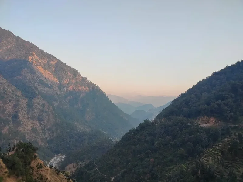
The weather is the ultimate arbiter of the Yatra experience. The region is prone to heavy monsoonal rains in July and August, which frequently cause landslides and road closures, making travel during this window extremely dangerous. The ideal windows are the pre-monsoon spring (May–June) and the post-monsoon autumn (September–October). During these times, the skies are often crystal clear, offering staggering views of peaks like Bandarpoonch, Shivling, Neelkanth, and the Chaukhamba massif. However, even in peak season, temperatures can drop below freezing at night, and sudden snowstorms are not uncommon at the higher shrines. This is a journey that requires meticulous planning, a respect for the mountains, and an openness to the chaotic, beautiful, and deeply moving culture of the Indian Himalayas.
History and Cultural Context
The origins of the Char Dham Yatra are shrouded in antiquity, blending historical fact with rich Vedic mythology. The circuit was formally organised and popularised by the 8th-century philosopher and theologian Adi Shankara. Seeking to revive Hinduism and unify the diverse spiritual practices of the Indian subcontinent, Shankara established various "Mathas" (monasteries) and identified these four Himalayan sites as essential destinations for seekers. However, the sanctity of these locations predates Shankara by millennia, appearing in the Puranas and the Mahabharata. The region is known as "Kedarkhand," the land of Lord Shiva, and is believed to be the place where the Pandavas sought penance after the Kurukshetra war.
Each shrine has its own unique historical and mythological narrative. Yamunotri is dedicated to Goddess Yamuna, the daughter of the Sun god Surya and sister of Yama, the god of death. Bathing in her waters is said to protect the devotee from an untimely death. Gangotri marks the spot where Goddess Ganga descended to Earth from the locks of Lord Shiva to wash away the sins of King Bhagirath's ancestors. Kedarnath is one of the twelve "Jyotirlingas" (radiant signs of Shiva) and is linked to the story of the Pandavas chasing Shiva, who had taken the form of a bull to elude them. Badrinath, dedicated to Lord Vishnu, is where the deity is said to have meditated in the form of "Badrinarayan" while his consort, Goddess Lakshmi, took the form of a Badri (jujube) tree to provide him shade.
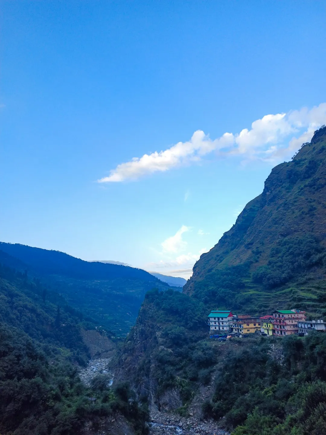
The architecture of the temples is equally significant. The Kedarnath temple, built of massive stone slabs, survived the catastrophic 2013 floods, an event many locals attribute to divine protection. The Badrinath temple, with its brightly painted facade and "Singh Dwara" (Lion Gate), reflects a blend of traditional Himalayan and more modern influences. For centuries, these shrines were accessible only to the most hardy ascetics and pilgrims who walked hundreds of kilometres on foot. It was only in the mid-20th century that road networks began to penetrate these deep valleys, transforming the Yatra into a journey accessible to millions, yet the sense of ancient devotion remains palpable in every village and trailside tea stall.
Want more background? Read extended notes on history and cultural context → Learn more
Seasonal Highlights and Weather Reality
The Char Dham Yatra is strictly seasonal, as the high-altitude temples are buried under several metres of snow during the winter. The temples typically open on the auspicious day of Akshaya Tritiya (late April or early May) and close shortly after Diwali (October or November). Outside this window, the "Utsav Murtis" (idols) of the deities are moved to lower-altitude winter abodes: Ukhimath for Kedarnath, Joshimath for Badrinath, Mukhba for Gangotri, and Kharsali for Yamunotri.
Spring (May to June): This is the most popular time for the Yatra. The weather is generally pleasant in the lower reaches, though still cold at the shrines. The snow has recently melted, leaving the meadows vibrant and the waterfalls at their peak flow. However, this is also the period of maximum crowding. Expect long queues at temples, heavy traffic on narrow mountain roads, and the need to book accommodation months in advance. Daytime temperatures at the shrines range from 10°C to 18°C, but can drop to 0°C at night.
Monsoon (July to August): Travel is strongly discouraged during these months. The Garhwal Himalayas receive intense rainfall, which leads to frequent landslides, flash floods, and "cloudbursts." Roads can be blocked for days, and the trekking trails become slippery and hazardous. While the landscape is incredibly lush and green, the risk to personal safety is high. Many experienced trekkers avoid the main Yatra during this time, though some visit the nearby Valley of Flowers, which blooms specifically during the rains.
Autumn (September to October): Many consider this the best time for the Yatra. The monsoon rains have washed the dust from the air, resulting in the clearest views of the high peaks. The crowds are significantly thinner than in the spring, and the atmosphere is more serene. The weather is crisp and cool, though by late October, the temperatures at Kedarnath and Badrinath can plummet well below freezing. This is the ideal window for photography and for those who prefer a quieter, more contemplative journey.
Recommended Itinerary
12-Day Char Dham Circuit Itinerary
Day 1: Rishikesh to Barkot
- Distance: 200 km (Drive)
- Time: 7–8 hours
- Drive through the scenic Mussoorie hills and along the Yamuna River
- Stop at Kempty Falls near Mussoorie
- Arrive in Barkot (1,220 m), a base for the Yamunotri trek
- Rest and acclimatise to the increasing altitude
Day 2: Barkot to Yamunotri and back
- Distance: 45 km drive to Janki Chatti; 6 km trek to Yamunotri (one-way)
- Elevation: 3,293 m at Yamunotri
- Time: 6–8 hours total trekking
- Early morning drive to Janki Chatti, the trailhead
- Steep trek to the Yamunotri temple; ponies and palanquins available
- Visit Surya Kund (hot spring) and Divya Shila
- Return to Barkot for overnight stay
Day 3: Barkot to Uttarkashi
- Distance: 82 km (Drive)
- Time: 4–5 hours
- Drive along the banks of the Bhagirathi River
- Visit the ancient Vishwanath Temple in Uttarkashi
- Uttarkashi (1,158 m) is a major spiritual hub and "Kashi of the North"
- Prepare for the high-altitude journey to Gangotri
Day 4: Uttarkashi to Gangotri and back
- Distance: 100 km drive (one-way)
- Elevation: 3,415 m at Gangotri
- Time: 7–8 hours total driving
- Drive through the stunning Harsil Valley, famous for apple orchards
- Visit the Gangotri Temple and the Bhagirath Shila
- Witness the "Gauri Kund" waterfalls near the temple
- Return to Uttarkashi for overnight stay
Day 5: Uttarkashi to Guptkashi
- Distance: 220 km (Drive)
- Time: 8–9 hours
- A long, scenic drive crossing from the Bhagirathi valley to the Mandakini valley
- Pass through Tehri Dam, one of the world's highest dams
- Arrive in Guptkashi (1,319 m), the gateway to Kedarnath
- Visit the Vishwanath and Ardhnareshwar temples
Day 6: Guptkashi to Kedarnath
- Distance: 30 km drive to Sonprayag/Gaurikund; 16 km trek to Kedarnath
- Elevation: 3,583 m at Kedarnath
- Time: 6–9 hours trekking
- Drive to Gaurikund, the starting point of the trek
- A strenuous uphill climb on a well-paved but steep trail
- Arrive at Kedarnath in the evening; witness the evening Aarti
- Overnight stay in basic guesthouses or tents near the temple
Day 7: Kedarnath to Guptkashi
- Distance: 16 km trek down to Gaurikund; 30 km drive to Guptkashi
- Time: 5–7 hours trekking and driving
- Early morning Darshan (viewing) of the Kedarnath Jyotirlinga
- Trek back down to Gaurikund
- Drive back to Guptkashi for a well-deserved rest
- Optional: Stay in Phata or Sitapur to shorten the travel day
Day 8: Guptkashi to Joshimath
- Distance: 160 km (Drive)
- Time: 6–7 hours
- Drive via Chopta, often called the "Mini Switzerland of India"
- Pass through the confluences of Rudraprayag and Karnaprayag
- Arrive in Joshimath (1,875 m), the winter seat of Badrinath
- Visit the Narasimha Temple and the ancient Shankaracharya Math
Day 9: Joshimath to Badrinath
- Distance: 45 km (Drive)
- Elevation: 3,133 m at Badrinath
- Time: 2–3 hours
- Drive through the narrow Alaknanda valley
- Visit the Badrinath Temple and take a dip in the Tapt Kund (hot springs)
- Explore Mana Village, the last Indian village before the Tibet border
- Overnight stay in Badrinath
Day 10: Badrinath to Rudraprayag
- Distance: 160 km (Drive)
- Time: 6–7 hours
- Begin the return journey following the Alaknanda River downstream
- Stop at Vishnuprayag and Nandprayag confluences
- Arrive in Rudraprayag (895 m), where the Alaknanda and Mandakini rivers meet
- Overnight stay in Rudraprayag
Day 11: Rudraprayag to Rishikesh
- Distance: 140 km (Drive)
- Time: 5–6 hours
- Visit Devprayag, the most significant confluence where the Alaknanda and Bhagirathi meet to form the Ganges
- Arrive back in Rishikesh (340 m)
- Evening Ganga Aarti at Triveni Ghat to conclude the Yatra
Day 12: Departure from Rishikesh
- Transfer to Jolly Grant Airport (Dehradun) or Haridwar Railway Station
- End of the sacred circuit
Planning and Bookings
Book Your Trip
Everything you need to plan your journey
Accommodation
Find places to stay near Rishikesh
Flights
Search flights to Rishikesh
Essential Preparation
The Char Dham Yatra requires significant logistical coordination. The most critical step is the mandatory Biometric Registration, which can be done online via the Uttarakhand Tourism portal or at physical kiosks in Rishikesh and Haridwar. Without this registration, you may be turned back at checkpoints. Fitness is paramount; even if you plan to use ponies or helicopters for the treks, the long hours of driving on winding mountain roads and the high altitude can be physically draining. It is highly recommended to spend at least two days in Rishikesh or Haridwar before starting to acclimatise and finalise transport.
Transport options include hiring a private taxi (the most flexible), joining a fixed-departure bus tour (the most economical), or booking a helicopter package (the fastest but most expensive). If driving, ensure your vehicle is in top condition and your driver is experienced in Himalayan terrain. Road conditions can change rapidly due to weather, so always build in at least one "buffer day" in your itinerary to account for potential delays.
Trail Accommodation
Accommodation along the Char Dham route ranges from basic ashrams and dharamshalas to mid-range hotels and government-run guesthouses (GMVN - Garhwal Mandal Vikas Nigam). During the peak season (May–June), everything sells out months in advance.
Hut and Lodge Facilities:
- GMVN Guesthouses: Generally the most reliable option, offering clean rooms, hot water (sometimes for a fee), and basic vegetarian meals.
- Private Hotels: Available in Barkot, Uttarkashi, Guptkashi, and Joshimath. Quality varies significantly; check recent reviews.
- Ashrams/Dharamshalas: Very basic, often with shared bathrooms. These are budget-friendly and offer a more traditional pilgrimage experience.
- Kedarnath Tents: Due to limited permanent structures at Kedarnath, many pilgrims stay in large, weather-proof tents provided by GMVN or private operators.
What is NOT Provided:
- Heating: Most budget and mid-range accommodations do not have central heating. Heavy blankets are usually provided, but you should bring thermal layers.
- Consistent Electricity: Power cuts are common in the mountains. Carry a power bank.
- Western Amenities: While many hotels have western toilets, many ashrams and smaller guesthouses only have squat toilets.
- Non-Vegetarian Food/Alcohol: The entire Char Dham circuit is a "dry" and vegetarian zone. Alcohol and meat are strictly prohibited.
Required Gear
- Trekking Boots: Sturdy, waterproof boots with good ankle support are essential for the Kedarnath and Yamunotri treks.
- Rain Gear: A high-quality waterproof jacket and trousers (or a heavy-duty poncho) are non-negotiable, as mountain weather is unpredictable.
- Layered Clothing: Merino wool or synthetic base layers, a fleece mid-layer, and a down jacket for the high-altitude nights.
- Backpack: A 30–40L daypack if you are using a porter/mule for your main luggage, or a 50–60L pack if carrying your own gear.
- Walking Poles: Highly recommended for the steep descents at Kedarnath to save your knees.
- Head Torch: Essential for early morning starts and navigating during power outages.
- Sun Protection: High-SPF sunscreen, lip balm with SPF, and polarised sunglasses to prevent snow blindness.
What to Bring
- Personal Medications: Include Diamox (for altitude sickness, after consulting a doctor), rehydration salts (ORS), pain relief, and basic first-aid supplies.
- Water Purification: A portable filter or purification tablets. While bottled water is available, reducing plastic waste is crucial.
- High-Energy Snacks: Dry fruits, nuts, energy bars, and chocolates to maintain energy during long treks and drives.
- Toiletries: Biodegradable soap, wet wipes, hand sanitiser, and a quick-dry towel.
- Cash: Many remote areas do not have ATMs, and network issues often make card or UPI payments impossible. Carry sufficient Indian Rupees in small denominations.
- Documents: Multiple copies of your Biometric Yatra registration, ID proof (Aadhar card or Passport), and emergency contact details.
Permits
The primary "permit" for the Char Dham Yatra is the mandatory Biometric Registration. This system was introduced to track the number of pilgrims and ensure safety following the 2013 floods. There is no fee for the registration itself, but it is a legal requirement for all travellers, including international tourists.
Registration Process:
- Online: Visit the official Uttarakhand Tourism website (registrationandtouristcare.uk.gov.in) or use the "Tourist Care Uttarakhand" mobile app. You will need to upload a photo and a copy of your ID.
- Offline: Registration counters are located at Haridwar Railway Station, Rishikesh Bus Stand, and several points along the route (e.g., Barkot, Sonprayag). Expect long queues at these physical locations.
- Verification: You will receive a "Yatra Registration Letter" or a physical card with a QR code. This will be scanned at various checkpoints throughout the journey.
Helicopter Bookings: If you intend to fly to Kedarnath, you must book your tickets through the official IRCTC Heli Yatra portal. Demand is astronomical, and tickets often sell out within minutes of being released. Be wary of third-party agents claiming to have "guaranteed" tickets, as scams are common. You must have a valid Yatra registration before you can book a helicopter ticket.
Special Permits: If you plan to extend your trek beyond the main shrines (e.g., to Gaumukh Glacier from Gangotri), you will need an additional permit from the District Forest Officer in Uttarkashi. These are limited to 150 people per day and should be arranged in advance.
Other Activities in the Area
The Garhwal region offers numerous opportunities to extend your adventure beyond the four main shrines:
- Yoga and Meditation in Rishikesh: Spend a few days in the "Yoga Capital of the World" before or after your Yatra. Attend a Ganga Aarti at Parmarth Niketan or take a class at one of the many world-renowned ashrams.
- White Water Rafting: For an adrenaline rush, the Ganges near Rishikesh offers world-class rapids (Grade II to IV), best experienced in March–April or September–October.
- Valley of Flowers National Park: A UNESCO World Heritage site located near Joshimath. This high-altitude valley blooms with hundreds of species of wild flowers between July and September.
- Hemkund Sahib: A sacred Sikh pilgrimage site located at 4,329 m, featuring a stunning glacial lake surrounded by seven snow-capped peaks. The trek starts from the same base as the Valley of Flowers.
- Auli Ski Resort: Located near Joshimath, Auli offers spectacular views of Nanda Devi and is a popular destination for skiing in winter and trekking in summer.
- Tungnath Trek: Visit the highest Shiva temple in the world, located on the way between Guptkashi and Joshimath. It is a relatively easy 4 km trek from Chopta.
Safety and Conditions
Altitude Sickness (AMS): This is the most significant health risk on the Yatra. Kedarnath and Gangotri are both above 3,000 metres. Symptoms of Acute Mountain Sickness include headache, nausea, dizziness, and fatigue. To prevent AMS: ascend slowly, stay hydrated (drink 3–4 litres of water daily), avoid alcohol, and consider taking preventative medication like Diamox. If symptoms persist or worsen, descend immediately.
Road Safety: The Himalayan roads are narrow, winding, and often carved into steep cliffs. Landslides are a constant threat, especially after rain. Avoid travelling at night, as visibility is poor and the risk of accidents increases. Ensure your driver is not fatigued and follows mountain driving etiquette (uphill traffic has the right of way).
Weather Extremes: Even in summer, temperatures at Kedarnath can drop to near zero. Hypothermia is a real risk if you get wet. Always carry waterproof layers and a warm jacket in your daypack, even if the morning starts sunny. In the event of a sudden storm, seek shelter immediately and do not attempt to cross high passes or steep trails.
Physical Strain: The treks to Yamunotri and Kedarnath are demanding. If you have pre-existing heart or lung conditions, consult a doctor before attempting the Yatra. Ponies, palanquins (dandis), and porters are available for those who cannot walk, but even these require a level of physical resilience to endure the bumpy ride and the thin air.
Emergency Contacts: Save the Uttarakhand state emergency helpline (108) and the SDRF (State Disaster Response Force) numbers. Mobile network coverage is patchy; BSNL and Jio generally have the best reach in the mountains, but expect long periods without signal.
Side Trips and Points of Interest
Mana Village: Located just 3 km beyond Badrinath, Mana is officially designated as the "Last Indian Village" before the border with Tibet. It is inhabited by the Marchas, a community of Bhotia people. Key sites here include the Vyas Gufa (where Sage Vyas is said to have composed the Mahabharata), the Ganesh Gufa, and the Bhim Pul—a massive natural stone bridge over the roaring Saraswati River.
Vasudhara Falls: A 5 km trek from Mana Village leads to these spectacular 122-metre waterfalls. Legend has it that the water of Vasudhara will not fall on anyone who is not pure of heart. The trek offers incredible views of the Alkapuri glacier and the surrounding peaks.
Tapt Kund and Surya Kund: These natural thermal springs at Badrinath and Yamunotri, respectively, are central to the pilgrimage ritual. The water in Surya Kund is hot enough to cook rice and potatoes, which pilgrims then take home as "Prasad." Bathing in the Tapt Kund at Badrinath is considered mandatory before entering the temple, providing a much-needed warmth in the cold mountain air.
Chopta (Mini Switzerland): Located on the route between Guptkashi and Joshimath, Chopta is a pristine meadow surrounded by dense forests of pine, deodar, and rhododendron. It serves as the base for the trek to Tungnath and Chandrashila Peak, offering one of the best 360-degree views of the Himalayan range, including Nanda Devi, Trishul, and Chaukhamba.
Leave No Trace
The Char Dham region is an ecologically sensitive zone that faces immense pressure from the millions of visitors it receives each year. As a traveller, it is your responsibility to minimise your impact on this sacred landscape. The "Land of the Gods" deserves to be treated with the utmost respect.
Guidelines for Responsible Travel:
- Plastic-Free Yatra: Avoid single-use plastic bottles. Carry a reusable bottle and use filtered water stations or purification tablets. Pack out all your plastic waste, including snack wrappers and wet wipes.
- Respect the Water: The rivers are considered holy. Do not use soap or detergents directly in the rivers or streams. Wash yourself and your clothes at least 30 metres away from any water source.
- Stay on the Path: In alpine meadows like those near Kedarnath or Chopta, stay on the designated trails to avoid trampling fragile high-altitude flora.
- Waste Management: Use the toilets provided at guesthouses and along the trails. If you must go in the wild, dig a "cathole" at least 15 cm deep and 60 metres away from water, trails, and campsites.
- Respect Local Culture: Dress modestly (shoulders and knees covered), especially when entering temples. Always ask for permission before taking photos of people or religious ceremonies.
- No Noise Pollution: The mountains are a place for peace and reflection. Avoid playing loud music and keep your voice low on the trails and in the temples.