Cervati Mountain Circuit - A Southern Italian Alpine Gem
The Cervati Mountain Circuit is a challenging multi-day walk nestled in the heart of the Cilento National Park, Campania, Southern Italy. This route offers a profound immersion into a rugged, ancient landscape, traversing high mountain passes, remote villages, and dramatic karst formations. It's a journey that rewards the intrepid with breathtaking panoramas, a deep connection to rural Italian life, and a sense of true wilderness often lost in more accessible mountain ranges. Unlike more famous Italian treks, the Cervati Circuit remains relatively undiscovered, offering a genuine sense of solitude and the opportunity to experience the authentic spirit of the Apennine mountains.
- Distance: 45.0 km
- Elevation Gain: 2500 m
- Duration: 3-4 days
- Difficulty: Challenging
- Best Time: June to September
- Closest City: Sapri
- Trailhead Access: Nearest airport: Naples (NAP). From Naples, take a train to Sapri. From Sapri, taxi or local bus to the trailhead near Sanza or Monte San Giacomo. Road conditions are generally good. Parking available near trailhead. No permits generally needed, but check local regulations before hiking.
Overview
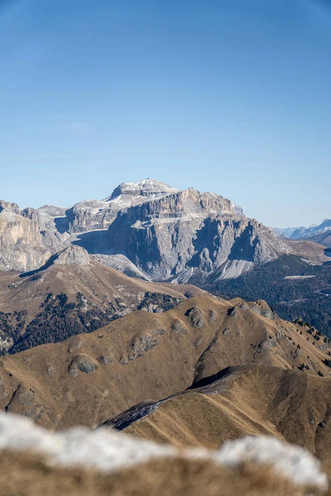
The Cervati Mountain Circuit is a demanding yet incredibly rewarding trek that circumnavigates Monte Cervati, the highest peak in the Cilento region. This route is not for the faint-hearted; it demands good physical fitness, navigational skills, and a willingness to embrace remote mountain environments. The circuit is typically completed over three to four days, allowing ample time to appreciate the diverse scenery and the unique cultural heritage of the area.
The trail begins its ascent from the lower slopes, gradually climbing through dense forests of beech and oak, interspersed with rocky outcrops and alpine meadows. As you gain altitude, the vegetation thins, revealing vast, sweeping vistas of the surrounding Apennine mountains and, on clear days, the shimmering Tyrrhenian Sea in the distance. The circuit is characterised by its significant elevation changes, with steep ascents and descents that test your stamina and provide a true mountain walking experience.
Key features of the Cervati Circuit include its dramatic karst landscapes, with sinkholes, caves, and unusual rock formations sculpted by millennia of erosion. You'll pass through remote shepherd settlements, offering glimpses into a traditional way of life that has persisted for centuries. The highest point of the circuit often involves traversing high mountain passes, where the air is crisp and the silence profound. The descent typically leads you through different ecological zones, showcasing the rich biodiversity of the Cilento National Park, a UNESCO World Heritage site renowned for its natural beauty and cultural significance.
This trek is an excellent choice for those seeking an authentic Italian mountain adventure away from the crowds. It offers a challenging physical experience combined with stunning natural beauty and a deep dive into the history and culture of Southern Italy.
History and Cultural Context
The Cilento region, and Monte Cervati in particular, has a long and rich history stretching back to ancient times. The area was inhabited by the Oenotrians, an ancient Italic people, and later became a significant part of Magna Graecia, with Greek colonies like Paestum flourishing nearby. The rugged terrain of Monte Cervati provided a natural refuge and a strategic vantage point throughout various historical periods.
For centuries, the mountains have been a vital resource for local communities, primarily for pastoralism. Shepherds have grazed their flocks on the high mountain pastures, following ancient transhumance routes that are still discernible today. The small, remote settlements and refuges you might encounter along the circuit are testaments to this enduring pastoral tradition. These structures, often simple stone buildings, were built to withstand the harsh mountain climate and provide shelter for shepherds and their animals.
The Cervati Mountain Circuit itself is not a formally designated "trail" in the same way as some of the more famous European long-distance paths. Instead, it is a network of ancient shepherd tracks, mule paths, and natural routes that have been used for generations. The modern circuit has been pieced together and marked by local hiking enthusiasts and park authorities, aiming to connect these historical pathways into a cohesive and challenging trek.
The area's cultural significance is further underscored by its designation as a UNESCO World Heritage site, recognised for both its outstanding natural beauty and its rich cultural landscape, which bears witness to a continuous human settlement from prehistoric times to the present day. Walking the Cervati Circuit is, therefore, not just a physical journey but also a step back in time, offering a tangible connection to the ancient history and enduring traditions of this remarkable region of Italy.
Seasonal Highlights and Weather Reality
The Cervati Mountain Circuit is best experienced during the warmer months, when the mountain passes are clear of snow and the weather is generally more stable. However, mountain weather can be unpredictable at any time of year.
Spring (April to May): The lower slopes begin to bloom with wildflowers, and the air is fresh. However, higher passes may still hold snow, and temperatures can be cool. This is a good time for those who enjoy a cooler climate and are prepared for potential snow patches. Rainfall can still be frequent.
Summer (June to August): This is the most popular season for hiking the circuit. The weather is typically warm and sunny, with long daylight hours. The mountain pastures are vibrant, and the views are often spectacular. However, summer can also bring intense heat at lower elevations, and thunderstorms can develop rapidly in the afternoons. Water sources can become scarcer in late summer.
Autumn (September to October): Autumn offers a beautiful display of changing foliage, particularly in the forested sections. The temperatures are cooler and more pleasant for hiking, and the crowds are thinner. The weather can be more variable, with an increased chance of rain and cooler temperatures, especially at higher altitudes. Snowfall can begin on the highest peaks by late October.
Winter (November to March): The Cervati Mountain Circuit is generally not recommended for hiking during winter. Heavy snowfall can make the passes impassable, and conditions can be extremely hazardous. Temperatures will be well below freezing at higher elevations, and avalanche risk is a significant concern. Only experienced winter mountaineers with appropriate gear and knowledge should consider attempting sections of the route during this period.
Weather Considerations: Regardless of the season, always be prepared for rapid weather changes in the mountains. Temperatures can drop significantly with altitude and with the onset of rain or wind. Always check the weather forecast before you set out and be ready to adapt your plans.
Recommended Itinerary
3-Day Cervati Mountain Circuit Itinerary
Day 1: Sanza to Rifugio Cervati (or nearby bivouac)
- Distance: Approximately 12-15 km
- Elevation Gain: Approximately 1000-1200 m
- Time: 5-7 hours
- Start from the village of Sanza, a common access point.
- The initial part of the trail ascends through mixed woodland, gradually increasing in gradient.
- Pass through areas with ancient beech trees and rocky terrain.
- Aim to reach the vicinity of Rifugio Cervati (check its operational status and booking requirements in advance) or a designated bivouac area.
- This day focuses on gaining significant altitude and immersing yourself in the mountain environment.
- Enjoy the expansive views as you climb higher.
Day 2: Rifugio Cervati to Rifugio Monte Sirino (or similar bivouac/village)
- Distance: Approximately 15-18 km
- Elevation Gain: Approximately 800-1000 m
- Elevation Loss: Approximately 700-900 m
- Time: 6-8 hours
- This is often the most challenging day, involving traversing high mountain passes and potentially reaching the highest points of the circuit.
- Navigate through alpine meadows, rocky scree slopes, and potentially karst formations.
- The route may pass near the summit of Monte Cervati (1898 m), offering spectacular 360-degree views.
- Descend towards the Monte Sirino area, which may have a rifugio or other basic accommodation options.
- Be prepared for exposed sections and potentially strong winds.
Day 3: Rifugio Monte Sirino to Monte San Giacomo (or return to Sanza)
- Distance: Approximately 12-15 km
- Elevation Gain: Approximately 400-600 m
- Elevation Loss: Approximately 800-1000 m
- Time: 4-6 hours
- The final day involves a descent through varied terrain, potentially passing through more forested areas or smaller hamlets.
- The route may lead towards Monte San Giacomo, another significant peak in the area, or directly back towards Sanza.
- Enjoy the final mountain vistas and the changing landscape as you descend.
- This day concludes the circuit, offering a sense of accomplishment after a challenging trek.
Alternative 4-Day Itinerary: For a more relaxed pace, consider breaking Day 2 into two shorter days, allowing more time for exploration of high passes or specific points of interest. This would involve finding suitable wild camping spots or smaller, more basic refuges/villages for an overnight stop.
Important Notes:
- Accommodation options (rifugi/bivouacs) can be basic and may require advance booking or confirmation of operational status.
- Water sources can be scarce at higher altitudes; carry sufficient water or a reliable purification method.
- Navigation is crucial; carry detailed maps and a compass/GPS device.
- Weather can change rapidly; always be prepared for rain, wind, and temperature drops.
- This is a challenging trek; ensure you have adequate fitness and experience.
Planning and Bookings
Book Your Trip
Everything you need to plan your journey
Accommodation
Find places to stay near Sapri
Flights
Search flights to Sapri
Essential Preparation
The Cervati Mountain Circuit requires thorough preparation due to its challenging nature and remote locations. Begin by assessing your fitness level; this is a demanding trek with significant elevation gain and loss, often on rough terrain. Ensure you are comfortable hiking for 5-8 hours per day with a loaded backpack.
Logistics are key. The nearest major transport hub is Naples. From Naples, you will need to take a train south to Sapri. Sapri is the closest coastal town with good rail connections. From Sapri, you will need to arrange onward transport to your chosen trailhead, typically near Sanza or Monte San Giacomo. Taxis are available in Sapri, but pre-booking is advisable, especially if travelling outside peak tourist times. Local buses may operate, but schedules can be infrequent and unreliable for reaching remote trailheads.
Accommodation along the route is limited and can be basic. Research the availability and operational status of any rifugi (mountain huts) or bivouacs you plan to use. Booking in advance is highly recommended, especially during the summer months. If relying on wild camping, ensure you are aware of local regulations and practice responsible camping. Consider basing yourself in Sapri or a nearby village for a night before and after your trek to allow for travel and acclimatisation.
Trail Accommodation
Accommodation options on the Cervati Mountain Circuit are sparse and can vary significantly in comfort and availability. It is essential to research and book in advance where possible.
Rifugi (Mountain Huts): There are a few mountain huts in the vicinity of Monte Cervati, such as Rifugio Cervati and potentially others near Monte Sirino. These huts typically offer basic dormitory-style sleeping arrangements, communal dining areas, and sometimes simple meals. Facilities can be rudimentary, with shared bathrooms and limited running water. Booking is usually mandatory, especially during peak season (June-September).
Bivouacs: In more remote areas, you may find basic bivouac shelters. These are often simple stone structures or small wooden cabins offering minimal protection from the elements. They typically provide just a roof and a place to sleep, with no other facilities. They are usually free to use on a first-come, first-served basis, but it's wise to have a backup plan.
Wild Camping: In some areas, wild camping may be permitted, but it is crucial to check local regulations and practice Leave No Trace principles rigorously. Choose established, durable surfaces away from water sources and trails. Be aware that regulations can change, and it's always best to err on the side of caution.
Villages: Depending on the exact route, you might pass through small villages where basic guesthouses or rooms to let (affittacamere) might be available. This is more likely on the approach or descent stages of the circuit.
What's NOT Provided: Huts and bivouacs generally do not provide bedding, cooking equipment, food, or electricity. You will need to bring your own sleeping bag, cooking gear, and all your food supplies.
Seasonal Availability: Most rifugi and bivouacs are typically open from late spring to early autumn (May to October). Outside these months, they may be closed or unstaffed, and access can be severely restricted by snow.
Costs: Costs for rifugi can vary, but expect to pay approximately €20-€40 per night for a dormitory bed. Bivouacs are usually free. Wild camping is free but requires self-sufficiency.
Required Gear
- Sturdy hiking boots: Waterproof, with good ankle support and well broken-in. Essential for the rough and uneven terrain.
- Waterproof and windproof jacket: A high-quality shell jacket is crucial for protection against sudden mountain weather changes.
- Waterproof overtrousers: To complement your jacket and keep you dry during rain.
- Warm layers: Including a fleece or down jacket, thermal base layers (merino wool or synthetic), and a warm hat and gloves. Temperatures can drop significantly at altitude, even in summer.
- Backpack: A comfortable and robust backpack of 45-65 litres, with a good hip belt and rain cover.
- Navigation tools: Detailed topographic maps of the area, a compass, and a GPS device or smartphone with offline maps. Ensure you know how to use them.
- Head torch: With spare batteries, essential for early starts, late finishes, or navigating in bivouacs.
- First-aid kit: Comprehensive kit including blister treatment, pain relievers, antiseptic wipes, bandages, and any personal medications.
- Sun protection: High SPF sunscreen, sunglasses, and a wide-brimmed hat. The sun can be intense at altitude.
- Trekking poles: Highly recommended for stability on ascents and descents, and to reduce strain on knees.
What to Bring
- Food: Sufficient non-perishable food for the duration of your trek, including breakfasts, lunches, dinners, and plenty of high-energy snacks. Plan meals carefully to minimise weight.
- Water treatment: A water filter or purification tablets. While streams are often present, treating water is always recommended.
- Cooking equipment: A lightweight camping stove, fuel, a pot, utensils, and a mug.
- Sleeping bag: A 3-season sleeping bag is recommended, rated for temperatures down to 0-5°C.
- Toiletries: Biodegradable soap, toothbrush, toothpaste, toilet paper, hand sanitiser, and any personal hygiene items.
- Personal items: Camera, power bank for electronics, book or journal, insect repellent (especially for lower elevations in summer).
- Cash: Small denominations of Euros for any small purchases in villages or for potential use at rifugi where card payment might not be accepted.
- Duct tape and cordage: Useful for repairs.
- Trash bags: To pack out all your waste.
Permits
Generally, no specific permits are required to hike the Cervati Mountain Circuit. The trails are part of the public domain and the Cilento National Park. However, it is always advisable to check with the park authorities or local tourist information offices for any specific regulations or temporary restrictions that may be in place, especially concerning wild camping or access to certain areas.
National Park Regulations: While no formal permits are needed for hiking, visitors are expected to adhere to the rules and guidelines of the Cilento National Park. This includes respecting the natural environment, staying on marked trails where they exist, and practising Leave No Trace principles. Information on park regulations can usually be found on the official website of the Parco Nazionale del Cilento, Vallo di Diano e Alburni.
Accommodation Bookings: If you plan to stay in rifugi or designated bivouacs, advance booking is highly recommended, and in some cases, mandatory. Contacting the specific accommodation providers directly is the best way to secure your spot and confirm their operating status and any associated fees.
Wild Camping: If you intend to wild camp, research the local regulations thoroughly. In Italy, wild camping is often a grey area; while not always explicitly permitted, it may be tolerated in remote areas if done discreetly and responsibly, away from protected zones and private property. Always pack out everything you pack in and leave no trace of your presence.
Local Information: For the most up-to-date information, it is best to consult local tourist information offices in towns like Sapri, Sanza, or Monte San Giacomo before you begin your trek. They can provide details on trail conditions, accommodation availability, and any specific park advisories.
Other Activities in the Area
The Cilento region offers a wealth of activities beyond the Cervati Mountain Circuit, making it an ideal destination for a longer stay:
- Explore the Cilento Coast: Discover charming coastal towns like Acciaroli, Pioppi, and Santa Maria di Castellabate. Enjoy beautiful beaches, crystal-clear waters, and delicious seafood.
- Visit Paestum: Step back in time at the remarkably well-preserved ancient Greek temples of Paestum, a UNESCO World Heritage site.
- Hike in other parts of the National Park: The Cilento National Park is vast and offers numerous other hiking trails, ranging from coastal walks to explorations of its diverse interior landscapes.
- Discover the Grotte di Castelcivita: Explore one of Italy's most extensive cave systems, featuring impressive stalactites and stalagmites.
- Experience local gastronomy: Cilento is the birthplace of the Mediterranean Diet. Savour local specialities like mozzarella, olive oil, fresh pasta, and regional wines.
- Visit Certosa di Padula: Explore the magnificent Carthusian Monastery of Padula, another UNESCO World Heritage site, known for its impressive architecture and vast cloister.
- Enjoy water sports: The coastline offers opportunities for swimming, snorkelling, diving, and sailing.
Safety and Conditions
Pre-Trip Checks:
- Weather Forecast: Always check the mountain weather forecast for the Cilento region before and during your trek. Websites like IlMeteo.it or local meteorological services can provide detailed forecasts. Be prepared for rapid changes, especially at higher altitudes.
- Trail Conditions: While the Cervati Circuit is not as formally maintained as some Alpine trails, local information can be obtained from park authorities or tourist offices regarding any recent landslides or significant trail damage.
- Accommodation Status: Confirm the operational status and opening dates of any rifugi or bivouacs you plan to use.
On-Trail Safety:
- Navigation: This is paramount. The trails can be faint in places, especially above the treeline. Carry detailed maps, a compass, and a GPS device or smartphone with offline maps. Inform someone of your planned route and expected return time.
- Water: Carry sufficient water, especially for higher sections where sources may be scarce. Always treat water from streams or springs.
- Altitude: While not extremely high, the circuit reaches elevations where the air is thinner. Ascend gradually and be aware of any symptoms of altitude sickness.
- Terrain: Be prepared for steep ascents and descents, rocky paths, scree slopes, and potentially slippery sections, especially after rain.
- Wildlife: While large dangerous wildlife is rare, be aware of snakes and insects.
- Communication: Mobile phone signal can be unreliable in remote mountain areas. Consider carrying a personal locator beacon (PLB) for emergencies.
- Emergency Contacts: Know the emergency numbers for Italy (112).
Hypothermia and Heatstroke: Be prepared for both extremes. Layer your clothing to adapt to changing temperatures. In summer, stay hydrated and avoid strenuous activity during the hottest parts of the day. In cooler conditions, ensure you have adequate warm layers and protection from wind and rain.
Travel Insurance: It is strongly recommended to have travel insurance that covers hiking and potential emergency evacuation.
Side Trips and Points of Interest
Monte Cervati Summit (1898 m): The highest point on the circuit, offering unparalleled panoramic views. If conditions permit and your itinerary allows, a detour to the summit is highly recommended. The climb can be steep and exposed, but the reward is immense, with vistas stretching across the Apennines and towards the sea.
Karst Formations: The Monte Cervati massif is known for its significant karst topography. Keep an eye out for sinkholes (doline), natural bridges, and cave entrances. These geological features are a testament to the erosive power of water over millennia.
Ancient Shepherd Paths: The circuit largely follows ancient routes used by shepherds for centuries. These paths, often marked by stone cairns or worn tracks, offer a tangible connection to the region's pastoral heritage. Imagine the lives of those who traversed these routes with their flocks.
Remote Villages and Hamlets: Depending on the specific route taken, you may pass through or near small, isolated villages or hamlets. These offer a glimpse into traditional rural Italian life, often unchanged for generations. They can be excellent places to rest, resupply (if available), and experience authentic local culture.
Panoramic Viewpoints: Numerous points along the circuit offer spectacular viewpoints. Take time to pause, especially on clear days, to admire the vastness of the landscape, the rolling hills, distant mountains, and the distant glint of the Tyrrhenian Sea.
Flora and Fauna: The Cilento National Park is rich in biodiversity. During spring and early summer, the mountain meadows are carpeted with wildflowers. Keep an eye out for various bird species, and if you are lucky, you might spot chamois or other mountain fauna.
Leave No Trace
The Cervati Mountain Circuit traverses a pristine natural environment within the Cilento National Park. Adhering to Leave No Trace principles is crucial to preserving this fragile ecosystem for future generations and ensuring a positive experience for all visitors.
Plan Ahead and Prepare: Research your route thoroughly, understand the terrain, and be aware of accommodation and water availability. Pack appropriately for all conditions.
Travel and Camp on Durable Surfaces: Stick to established trails whenever possible. If camping, choose established campsites or durable surfaces away from water sources and vegetation. Avoid creating new paths.
Dispose of Waste Properly: Pack out everything you pack in, including all food scraps, wrappers, and toilet paper. Use designated toilets where available. If no facilities exist, dig a cathole at least 60 metres away from water, trails, and campsites.
Leave What You Find: Do not remove or disturb natural objects such as rocks, plants, or historical artefacts. Take only photographs and memories.
Minimise Campfire Impacts: Campfires are generally discouraged or prohibited in national parks. If permitted and necessary, use established fire rings and keep fires small. Ensure they are completely extinguished before leaving.
Respect Wildlife: Observe wildlife from a distance. Never feed animals, as it can disrupt their natural behaviours and diets. Store food securely to prevent attracting animals.
Be Considerate of Other Visitors: Keep noise levels down, especially in remote areas. Yield to other hikers on narrow trails. Respect the local culture and traditions.
By following these principles, you help protect the natural beauty and cultural heritage of the Cervati Mountain Circuit and the Cilento National Park.