Cerro Torre Trek - Journey to the Spire of Granite
The Cerro Torre Trek is one of the most iconic alpine experiences in the Southern Hemisphere, a journey that leads deep into the heart of Los Glaciares National Park in Argentine Patagonia. Spanning approximately 60 kilometres over four to five days, this circuit offers an unparalleled encounter with the raw, unbridled power of the Southern Patagonian Ice Field. The trek is defined by its namesake, Cerro Torre—a 3,128-metre granite needle often shrouded in "scud" clouds and crowned by a treacherous rime-ice mushroom. This is not merely a walk; it is a pilgrimage through a landscape of geological extremes, where ancient Lenga forests give way to glacial moraines, and turquoise lagoons serve as the final resting place for icebergs calved from the Great Glacier Grande.
Starting and ending in the vibrant mountain village of El Chaltén, the "Trekking Capital of Argentina," the route weaves through the Fitz Roy and Torre valleys. It connects the two most famous massifs in the region, providing walkers with shifting perspectives of vertical granite walls that have haunted the dreams of world-class climbers for decades. The trek demands respect for the notorious Patagonian winds—the "Roaring Forties"—which can transform a calm morning into a test of endurance within minutes. Yet, for those who traverse these paths, the reward is a profound sense of isolation and a front-row seat to one of the most dramatic mountain skylines on Earth. This is a wilderness where nature remains the ultimate architect, and every kilometre reveals a new facet of Patagonia's haunting, jagged beauty.
- Distance: 60.0 km (full circuit including side trips)
- Duration: 4–5 days
- Season: October to April (Best in November or March for stability)
- Accommodation: Wilderness campsites (Campamento Poincenot, Campamento De Agostini)
- Highest point: Laguna de los Tres / Maestri Viewpoint (approx. 1,200 m)
- Difficulty: Challenging (due to weather and terrain, not technicality)
- Direction: Usually completed as a loop or "P" shaped circuit from El Chaltén
Overview
The Cerro Torre Trek is a masterclass in Patagonian geography. Unlike many high-altitude treks in the Andes, this route stays primarily in the valleys and on the lower moraines, meaning walkers spend less time struggling with oxygen deprivation and more time immersed in the sheer verticality of the landscape. The trek is designed to showcase the contrast between the lush, deciduous beech forests (Lenga and Ñire) and the sterile, monochromatic world of the high glaciers. The route typically links the Fitz Roy valley with the Torre valley via the "Lagunas Madre e Hija" (Mother and Daughter Lakes) trail, creating a comprehensive loop that captures the essence of the region.
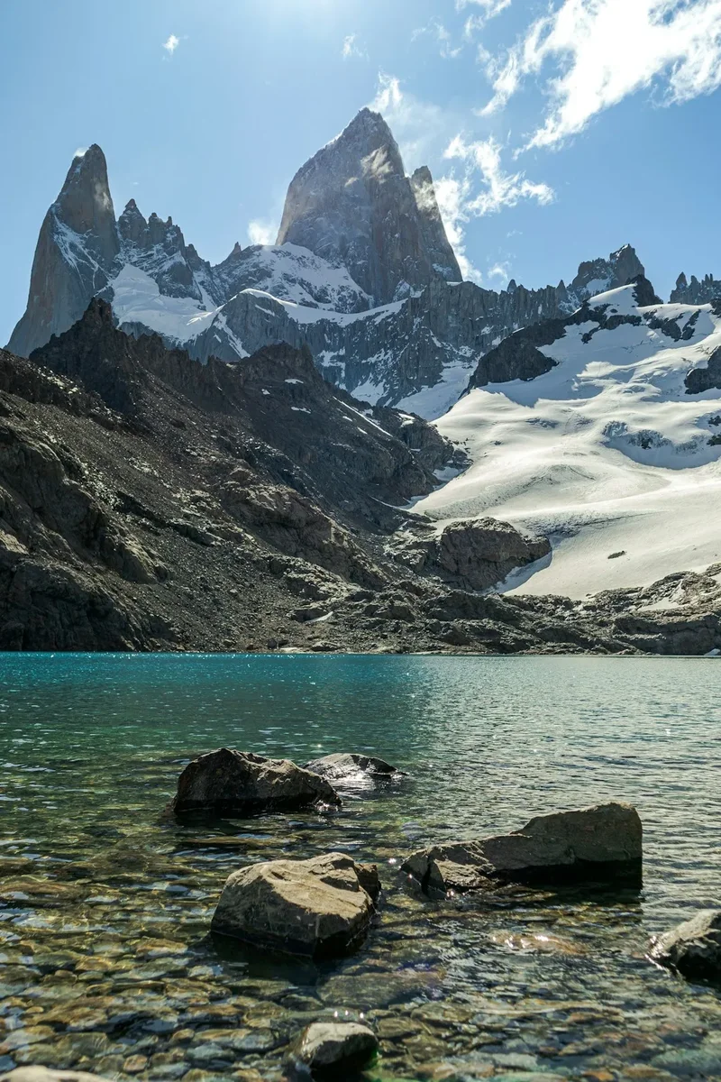
The primary objective for many is reaching the shores of Laguna Torre. Here, the Glacier Grande spills into the lake, sending small icebergs drifting toward the shore. On a clear day, the view from the lake's edge toward Cerro Torre, Torre Egger, and Aguja Standhardt is arguably the most impressive mountain vista in South America. The spires rise nearly two vertical kilometres from the glacier floor, their sheer faces polished by wind and ice. The trek also incorporates the legendary Laguna de los Tres, which sits at the base of Mount Fitz Roy (Chaltén), providing a dual-peak experience that defines the Los Glaciares experience.
What sets this trek apart is the accessibility combined with the wildness. While the trailheads are mere metres from the cafes of El Chaltén, within two hours of walking, you are in a world where the only sounds are the thunderous cracks of calving glaciers and the cry of the Magellanic woodpecker. The terrain is a mix of well-trodden forest paths, rocky river crossings, and steep, unstable moraine slopes. It is a physical challenge that requires steady footing and a high tolerance for rapidly changing weather, but it does not require technical climbing skills. It is the quintessential Patagonian experience: rugged, beautiful, and entirely unpredictable.
The 60-kilometre distance accounts for the primary loop and the essential side trips to viewpoints like the Mirador Maestri and the Piedras Blancas glacier. These detours are not optional for the true enthusiast; they provide the context and the scale necessary to understand the glacial systems that have carved these valleys over millennia. To walk the Cerro Torre Trek is to witness the ongoing battle between stone and ice, a slow-motion geological drama played out in one of the windiest corners of the globe.
History and Cultural Context
The history of the Cerro Torre region is a blend of indigenous heritage, early exploration, and some of the most controversial chapters in mountaineering history. Long before European explorers arrived, the region was the ancestral home of the Aonikenk (Tehuelche) people. They called the dominant peak "Chaltén," which translates to "Smoking Mountain," a reference to the near-constant cap of clouds that clings to the summit, often mistaken for volcanic smoke. To the Aonikenk, these mountains were sacred, and while they did not climb the high peaks, they navigated the valleys for hunting and seasonal migration.
European recognition came in the late 19th century. In 1877, the Argentine explorer Francisco "Perito" Moreno named the highest peak Mount Fitz Roy in honour of Robert FitzRoy, the captain of the HMS Beagle. However, Cerro Torre remained a mystery for much longer, its impossible verticality leading many early explorers to believe it was "unclimbable." The mountain became the centre of a global controversy in 1959 when Italian climber Cesare Maestri claimed the first ascent with Toni Egger. Egger perished in an avalanche during the descent, and with him, the only camera containing proof of their success. Decades of subsequent attempts by elite climbers failed to find any trace of Maestri’s route, leading to widespread doubt. In a fit of defiance, Maestri returned in 1970 and used a petrol-powered compressor to drill hundreds of bolts into the rock, creating the "Compressor Route." This act remains one of the most debated events in climbing history, highlighting the tension between human ambition and wilderness preservation.
The village of El Chaltén itself has a unique history. It was founded as recently as 1985, not for tourism, but as a strategic move by the Argentine government to establish a permanent settlement in a disputed border zone with Chile. Since then, it has evolved from a dusty outpost into a world-renowned trekking hub. The trails you walk today were largely pioneered by these early residents and the National Park rangers (Guardaparques), who have worked to balance the influx of international visitors with the need to protect the fragile sub-antarctic ecosystem. Walking these trails today, one is treading on ground that has seen more drama in the last 70 years than many mountain ranges see in a millennium.
Want more background? Read extended notes on history and cultural context → Learn more
Seasonal Highlights and Weather Reality
Weather is the defining characteristic of the Cerro Torre Trek. Located at approximately 49 degrees south, the region is directly in the path of the prevailing westerly winds that sweep across the Pacific and the Southern Patagonian Ice Field. This creates a microclimate where "four seasons in one day" is not a cliché, but a daily reality.
Summer (December to February): This is the peak trekking season. Days are long, with daylight lasting until 10:00 PM, providing ample time for long distances. Temperatures are generally mild, ranging from 10°C to 20°C during the day, though they can drop to near freezing at night. However, summer is also the windiest season. Gusts exceeding 100 km/h are common, particularly on exposed ridges and moraines. These winds can make walking difficult and can even blow trekkers off their feet.
Shoulder Seasons (October–November and March–April): Many experienced trekkers prefer these months. November offers the blooming of the Ciruelillo (Firebush), which paints the valleys in vibrant red. March and April bring the spectacular autumn colours, as the Lenga forests turn brilliant shades of orange and deep crimson. The winds are often less ferocious than in mid-summer, though the temperatures are cooler and the chance of early or late snow increases. April, in particular, offers the best chance for the "still" days required for perfect reflections of Cerro Torre in the lagoons.
Winter (May to September): The trek becomes a serious winter expedition. Most services in El Chaltén close, and the trails are often buried under deep snow. Daylight is short, and temperatures frequently remain well below freezing. Only those with advanced winter navigation and survival skills should attempt the circuit during this time, as the risk of hypothermia and getting lost is significantly higher. The lagoons freeze over, and the landscape becomes a silent, white wilderness.
Regardless of the season, the "Patagonian Factor" must be accounted for. Rain can be horizontal, and the sun can be piercingly intense due to the thin ozone layer in the southern latitudes. A clear morning is never a guarantee of a clear afternoon. Successful trekkers are those who remain flexible with their itinerary, often building in "buffer days" to wait out the worst of the storms in the safety of the forest or the village.
Recommended Itinerary
4-Day Cerro Torre & Fitz Roy Circuit
Day 1: El Chaltén to Campamento Poincenot
- Distance: 10 km
- Elevation gain: 350 m
- Time: 3–4 hours
- Start at the northern end of El Chaltén at the Fitz Roy trailhead
- Steady climb through Lenga forest to the Mirador del Fitz Roy
- Continue past Laguna Capri, a beautiful lake with the first major views of the massif
- Arrive at Campamento Poincenot, the primary base camp for the Fitz Roy area
- Set up camp and enjoy the evening light on the granite walls of Aguja Mermoz and Fitz Roy
- The trail is well-maintained and serves as an excellent introduction to the local terrain
Day 2: Laguna de los Tres and Piedras Blancas Glacier
- Distance: 12 km (return from camp)
- Elevation gain: 500 m
- Time: 5–6 hours
- Early start for sunrise at Laguna de los Tres (the steepest kilometre of the trek)
- Witness the "Alpenglow" as the granite of Fitz Roy turns bright orange
- Explore the hidden Laguna Sucia nearby for a more secluded experience
- Afternoon side trip to the Mirador Piedras Blancas to see the hanging glacier
- Return to Campamento Poincenot for a second night
- This day involves the most significant vertical gain but offers the most iconic views of the circuit
Day 3: Campamento Poincenot to Campamento De Agostini
- Distance: 15 km
- Elevation gain: 200 m (mostly undulating)
- Time: 5–6 hours
- Traverse the "Lagunas Madre e Hija" trail, connecting the two main valleys
- Walk through ancient forests and across open marshes with views of the Torre massif
- Pass the shores of the Mother and Daughter lakes, often seeing waterfowl and trout
- Descend into the Torre valley and follow the Fitz Roy river upstream
- Arrive at Campamento De Agostini, nestled in the trees near the shore of Laguna Torre
- This section is less crowded than the main Fitz Roy trail and offers a sense of deep wilderness
Day 4: Laguna Torre, Mirador Maestri, and Return to El Chaltén
- Distance: 23 km
- Elevation gain: 250 m
- Time: 7–9 hours
- Pre-dawn walk to the shore of Laguna Torre for sunrise
- Hike along the lateral moraine to Mirador Maestri for a close-up view of Glacier Grande and Cerro Torre
- Observe the icebergs in the lake and the sheer scale of the Torre Egger spire
- Begin the long but gentle descent back toward El Chaltén via the Torre Valley trail
- Pass the Mirador del Torre for a final look back at the mountains
- Finish the trek in El Chaltén for a celebratory meal and local craft beer
- The final day is long in distance but mostly downhill, making it a rewarding conclusion to the journey
Important Notes:
- Campsites are free and operate on a first-come, first-served basis
- Water is abundant in streams; while generally pure, treatment is recommended near campsites
- High winds on the Day 4 moraine walk can be dangerous; exercise caution
- Always check the wind forecast at the Ranger Station before heading to Mirador Maestri
- Pack out all waste; there are no bins at the wilderness camps
Planning and Bookings
Book Your Trip
Everything you need to plan your journey
Accommodation
Find places to stay near El Chalten
Flights
Search flights to El Chalten
Essential Preparation
Preparation for the Cerro Torre Trek begins with logistics in El Calafate, the nearest major city with an airport (FTE). From El Calafate, a three-hour bus journey takes you to El Chaltén. It is highly recommended to spend at least one night in El Chaltén before starting the trek to check weather forecasts, register at the National Park office (Guardaparques), and purchase any last-minute supplies. Fitness requirements are moderate; while the trails are not technically difficult, carrying a full multi-day pack over uneven terrain for 15–20 kilometres a day requires a good level of cardiovascular health and leg strength.
Booking coordination is relatively simple compared to other major treks like the Torres del Paine "W" or the Milford Track. Because the campsites within Los Glaciares National Park are free and do not require reservations, the primary logistical hurdle is ensuring you have high-quality camping gear and enough food. El Chaltén has several outdoor gear shops that offer rentals for tents, sleeping bags, and stoves, but during the peak months of January and February, these can sell out. It is wise to reserve rental gear in advance if you are not bringing your own.
Trail Accommodation
Accommodation on the Cerro Torre Trek consists of designated wilderness campsites managed by the Administración de Parques Nacionales (APN). There are no mountain huts or lodges along this specific route, meaning you must be self-sufficient with a tent and sleeping gear.
Campamento Poincenot and Campamento De Agostini:
- Facilities: These are basic sites. They provide cleared areas for tents and basic pit toilets (latrines). There are no showers, no electricity, and no trash collection.
- Water: Water is sourced from nearby streams. While the water in this region is famously pure, it is best practice to filter or treat water collected near the campsites due to the high volume of trekkers.
- Cost: Free. There are no fees for camping within the national park boundaries on these specific trails.
- Availability: No bookings are possible. During peak season, sites can become very crowded; it is advisable to arrive by early afternoon to secure a good spot.
- What is NOT provided: No food, no fuel, no bedding, and no shelter from the wind other than what you bring.
Required Gear
- Tent: A high-quality 3-season or 4-season tent is essential. It must be able to withstand high winds (60–100 km/h). Lightweight "ultralight" tents may struggle unless they are specifically designed for high-wind environments.
- Sleeping Bag: Rated to at least -5°C (comfort rating). Even in summer, night temperatures can drop significantly.
- Footwear: Sturdy, waterproof trekking boots with good ankle support. The terrain includes rocky moraines and muddy forest paths.
- Clothing Layers: The layering system is vital. Include a moisture-wicking base layer (merino wool is best), an insulating mid-layer (fleece or down), and a high-quality waterproof and windproof outer shell (Gore-Tex or similar).
- Navigation: While trails are well-marked, a physical map and a GPS app with offline maps (like Gaia GPS or AllTrails) are necessary for safety in low visibility.
- Backpack: A 50–65 litre pack with a rain cover. Ensure it is fitted correctly to distribute weight to your hips.
What to Bring
- Food: All meals for 4–5 days. Focus on high-calorie, lightweight options like dehydrated meals, nuts, dried fruit, and chocolate. There are no shops on the trail.
- Cooking System: A reliable stove (gas canisters are easily found in El Chaltén) and a lightweight pot. Remember a lighter and a backup.
- Water Treatment: A lightweight filter (like a Sawyer Squeeze) or purification tablets.
- Sun Protection: High SPF sunscreen, lip balm with SPF, and polarised sunglasses. The UV radiation is exceptionally high here.
- First Aid: Blister kits (Compeed), ibuprofen, antiseptic wipes, and any personal medications.
- Personal Items: Biodegradable toilet paper, a small trowel (though latrines are provided at main camps), and a headlamp with spare batteries.
- Trash Bags: You must carry out every scrap of waste, including organic matter like orange peels or tea bags.
Permits
As of the current season, no formal permits or fees are required to enter the northern sector of Los Glaciares National Park for trekking on the standard routes. This makes the Cerro Torre Trek one of the most accessible world-class hikes in terms of bureaucracy. However, there are several administrative steps and rules that every trekker must follow to ensure the continued health of the park and their own safety.
Registration and Regulations:
- National Park Office: Upon arrival in El Chaltén, all trekkers are encouraged to visit the Guardaparques (Ranger) station located at the entrance of the town. Here, you can receive the latest weather updates, trail condition reports, and safety briefings.
- Voluntary Registration: For more remote sections or if you are trekking solo, it is highly recommended to leave your itinerary with the rangers or your accommodation provider in town.
- Group Size: There are no strict limits on group size for independent trekkers, but large organised groups may need special authorisation.
- Stay Limits: While there is no formal permit, the park asks that you do not stay more than two consecutive nights in the same campsite to reduce environmental impact.
Important Restrictions:
- No Fires: Lighting fires is strictly prohibited throughout the national park. This rule is enforced with heavy fines and potential expulsion from the park. Use only gas or liquid fuel stoves for cooking.
- Camping Areas: You must only camp in the designated "Campamentos." Wild camping in non-designated areas is not permitted to protect the fragile soil and vegetation.
- Drones: The use of drones is strictly forbidden within the national park to protect wildlife and the experience of other visitors.
While the lack of a permit fee is a benefit, it also means the park relies on the "Leave No Trace" ethics of its visitors. The rangers are active on the trails and will check that you are following the rules, particularly regarding fire and waste management.
Other Activities in the Area
El Chaltén and the surrounding Los Glaciares National Park offer a wealth of activities for those with extra time or those looking for a break from multi-day trekking:
- Ice Trekking on Viedma Glacier: Take a boat across Lake Viedma and strap on crampons to explore the blue ice, crevasses, and ice caves of Argentina's largest glacier.
- Rock Climbing: El Chaltén is a world-class climbing destination. While the big spires are for experts, there are many granite crags near the town suitable for beginners and intermediates with local guides.
- Huemul Circuit: For those seeking a more technical and remote challenge, this 4-day trek involves river crossings by zip-line and incredible views of the Southern Patagonian Ice Field.
- Lago del Desierto: A 37 km drive north of town leads to this stunning lake. You can take a boat across to the Chilean border or hike to the Huemul Glacier.
- Mountain Biking: Several trails around the valley floor are open to mountain bikes, offering a different way to see the Rio de las Vueltas.
- Fly Fishing: The rivers and lakes around El Chaltén are famous for trout. Local guides offer day trips for catch-and-release fishing in pristine waters.
- Craft Beer Tasting: El Chaltén has a thriving microbrewery scene. After a long trek, visiting places like La Cervecería or Fresco is a local tradition.
Safety and Conditions
Weather Awareness: The primary safety concern in Patagonia is the weather. High winds can make crossing moraines or ridges dangerous, and sudden drops in temperature can lead to hypothermia. Always check the "Windguru" or "Meteoblue" forecasts specifically for El Chaltén and the surrounding peaks. If winds are predicted to exceed 80 km/h, it is often safer to stay in the forest or return to town.
Terrain Hazards: The trail to Mirador Maestri and Laguna de los Tres involves steep, loose rock (scree) and large boulders. Ankle injuries are the most common medical issue on these trails. Trekking poles are highly recommended to provide stability, especially when carrying a heavy pack. River crossings are generally bridged on the main trails, but after heavy rain, small streams can become difficult to cross.
Water and Health: While the water is generally safe, the increase in tourism has put pressure on the local watersheds. Always collect water upstream from campsites and use a filter. Giardia is rare but not unheard of. Ensure you are familiar with the symptoms of hypothermia and carry an emergency space blanket at all times.
Emergency Services: There is no cell phone signal once you leave the village of El Chaltén. In the event of an emergency, you must send someone to the nearest Ranger Station or back to town. Carrying a satellite communication device like a Garmin inReach or a Zoleo is highly recommended for solo trekkers or those heading into more remote areas. The local volunteer rescue team (Comisión de Auxilio) is highly skilled but relies on donations and may take many hours to reach you.
Wildlife: The most significant wildlife concern is the Puma. While sightings are rare, they do inhabit the park. If you encounter a puma, do not run; stand your ground, make yourself look large, and shout. Do not leave food inside your tent, as it can attract smaller scavengers like foxes and mice.
Side Trips and Points of Interest
Mirador Maestri: This is the essential extension of the Cerro Torre Trek. From the shore of Laguna Torre, a trail leads along the crest of the right-hand lateral moraine. It takes about an hour to reach the viewpoint named after Cesare Maestri. From here, you are significantly closer to the Glacier Grande and have a much clearer view of the technical climbing routes on the Torre massif. The perspective of the ice flowing down from the Adela range is breathtaking.
Laguna Sucia: Often overlooked by those rushing to Laguna de los Tres, Laguna Sucia (Dirty Lagoon—though it is anything but) sits in a hanging valley to the left of the main Fitz Roy viewpoint. It features hanging glaciers that frequently calve into the deep blue water, creating spectacular waterfalls. The path is unmaintained and involves some light scrambling over boulders, but the solitude and beauty are well worth the extra 90 minutes.
Piedras Blancas Glacier: Located a short walk from Campamento Poincenot, this viewpoint offers a classic look at a "hanging" glacier. You can watch as chunks of ice break off and tumble down the rock face. It is one of the best places in the park to hear the "thunder" of the mountains—the sound of moving ice echoing through the valley.
Chorrillo del Salto: A beautiful 20-metre waterfall located just a short walk from the town of El Chaltén. It is a perfect "warm-up" or "cool-down" walk that doesn't require a full pack. The forest surrounding the falls is particularly lush and provides a great opportunity for birdwatching, including the chance to see the large Magellanic Woodpecker with its distinctive red head.
Leave No Trace
Los Glaciares National Park is a fragile sub-antarctic ecosystem that faces increasing pressure from global tourism. The "Leave No Trace" principles are not just guidelines here; they are essential for the survival of the park's biodiversity. The soil is thin and easily eroded, and the cold climate means that organic waste takes years to decompose.
Core Principles for Patagonia:
- Plan Ahead and Prepare: Know the weather and your limits to avoid needing rescue, which puts strain on local resources.
- Travel and Camp on Durable Surfaces: Stay on the marked trails. Taking shortcuts across switchbacks causes massive erosion and destroys the root systems of the Lenga trees.
- Dispose of Waste Properly: "Pack it in, pack it out" applies to everything. This includes fruit peels, nut shells, and used toilet paper. Use the pit toilets at campsites whenever possible. If you must go elsewhere, dig a "cathole" 15–20 cm deep and at least 60 metres from water.
- Leave What You Find: Do not take rocks, plants, or archaeological artefacts. The fossils found in some areas of the park are protected by law.
- Minimise Campfire Impacts: Fires are strictly forbidden. A single spark can (and has) destroyed thousands of hectares of ancient forest in Patagonia.
- Respect Wildlife: Observe animals from a distance. Never feed foxes or birds, as this makes them dependent on humans and can lead to aggressive behaviour.
- Be Considerate of Others: Keep noise levels low. Many people come to these mountains for the silence. Yield to uphill trekkers on narrow paths.