Cerro Madsen Ascent - A Patagonian Challenge
The Cerro Madsen Ascent is a demanding mountain track located in the heart of Argentinian Patagonia, offering a strenuous but incredibly rewarding day hike for experienced trekkers. This route plunges you into a landscape of dramatic granite spires, glacial valleys, and windswept plateaus, characteristic of the region surrounding El Chaltén, Argentina's trekking capital. The ascent to Cerro Madsen is not for the faint of heart; it requires significant physical exertion, navigational skills, and a robust appreciation for wild, untamed environments. The trail culminates in breathtaking panoramic views that stretch across the vast Southern Patagonian Ice Field and surrounding peaks, a true testament to the raw beauty of this iconic mountain range.
- Distance: 12.0 km one-way
- Elevation Gain: 1,100 m
- Duration: 8–10 hours round trip
- Difficulty: Challenging
- Season: December to March (Southern Hemisphere summer)
- Closest City: El Chaltén
- Trailhead Access: El Chaltén town centre; no vehicle required
- Coordinates: -49.2694, -72.9922
Overview
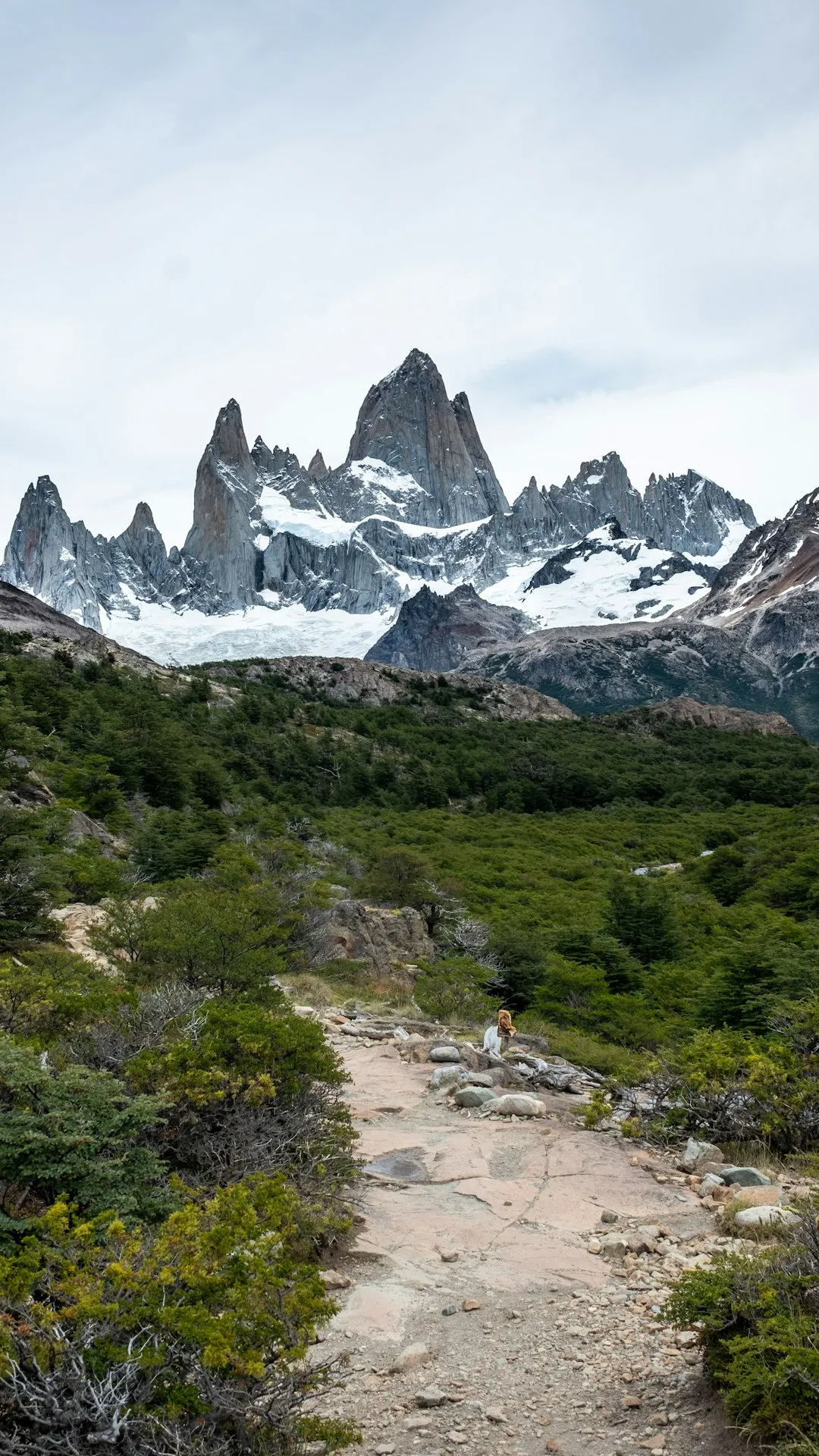
The Cerro Madsen Ascent is a quintessential Patagonian trek, embodying the spirit of adventure that draws thousands to El Chaltén each year. Unlike the more famous Fitz Roy or Cerro Torre circuits, Cerro Madsen offers a less crowded, yet equally spectacular, experience. The trail begins with a relatively gentle introduction, winding through lenga forests and alongside clear mountain streams. However, this initial phase is merely a prelude to the significant challenge that lies ahead. As the tree line recedes, the terrain transforms into scree slopes and rocky ascents, demanding steady footwork and considerable stamina.
The defining characteristic of this hike is its relentless elevation gain. Over approximately 6 kilometres, you will ascend a staggering 1,100 metres. This steep gradient means that progress can be slow, and every metre gained is hard-earned. The landscape opens up dramatically as you climb, revealing increasingly expansive vistas. The air becomes thinner, the wind stronger, and the sense of being in a truly wild, exposed environment intensifies. The summit of Cerro Madsen, while not a technically difficult climb in terms of mountaineering, presents a significant physical and mental test due to its steepness and the exposed nature of the terrain.
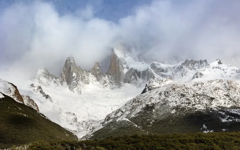
Upon reaching the summit, the reward is immense. The 360-degree views are simply phenomenal. To the north, the iconic spires of Fitz Roy and Cerro Torre may be visible on a clear day, though often partially obscured by other peaks. More prominently, the vast expanse of the Southern Patagonian Ice Field dominates the horizon, a seemingly endless sea of ice and snow that stretches for hundreds of kilometres. Glacial lakes, often a striking turquoise or deep blue, dot the landscape below. The sheer scale and raw power of nature are palpable from this vantage point, making the arduous climb entirely worthwhile. This is a hike that tests your limits and rewards you with unparalleled Patagonian grandeur.
History and Cultural Context
The history of Cerro Madsen, like much of the El Chaltén region, is intertwined with the exploration and settlement of Patagonia. While specific historical accounts directly detailing the naming or early ascents of Cerro Madsen are less prominent than those for its more famous neighbours like Fitz Roy or Cerro Torre, the area's exploration dates back to the late 19th and early 20th centuries. European explorers and surveyors, driven by a desire to map and understand this remote and rugged territory, gradually charted the valleys and peaks.
The name "Madsen" itself suggests a possible connection to early settlers or explorers of Scandinavian origin, a common occurrence in Patagonian place names due to significant immigration from Norway, Sweden, and Denmark. These early pioneers faced immense challenges, navigating treacherous terrain, unpredictable weather, and vast distances with limited resources. Their efforts laid the groundwork for the modern trekking routes that are now accessible to adventurers from around the globe.
The establishment of El Chaltén as a national park and trekking hub in the latter half of the 20th century transformed the region from a remote frontier into a world-renowned destination. The development of trails, including those leading to peaks like Cerro Madsen, was often a collaborative effort between park authorities and local guides, aiming to provide safe access to the stunning natural beauty while minimising environmental impact. The cultural context of the region is also deeply rooted in the indigenous Tehuelche people, who inhabited these lands for millennia, possessing an intimate knowledge of the environment long before European arrival. While their direct connection to specific peak names might be less documented in Western records, their ancestral presence and stewardship of this land are an integral part of Patagonia's heritage.
Seasonal Highlights and Weather Reality
The Cerro Madsen Ascent is a summer-only trek, with the optimal window for attempting this challenging hike falling between December and March. This period corresponds to the Southern Hemisphere's summer, offering the longest daylight hours and the highest probability of encountering favourable weather conditions.
Summer (December to March): This is the prime season for trekking in El Chaltén. Daylight extends well into the evening, allowing for ample time to complete the demanding 8–10 hour round trip. Temperatures are generally milder, though still highly variable. You can expect daytime temperatures to range from 10°C to 20°C, but it is crucial to be prepared for much colder conditions, especially at higher elevations and during windy spells. Snow can still be present on the upper reaches of the trail, particularly in early December or late March, and icy patches can form overnight. The primary challenge during summer is the infamous Patagonian wind, which can be relentless and extremely strong, significantly increasing the perceived temperature and making progress difficult.
Shoulder Seasons (November and April): While technically possible, these months are less ideal. November can still see significant snowfall and colder temperatures, and daylight hours are shorter than in mid-summer. April brings autumn colours to the lenga forests, which can be stunning, but the weather becomes increasingly unpredictable, with a higher chance of snow, stronger winds, and shorter days. For a challenging ascent like Cerro Madsen, sticking to the core summer months is strongly recommended for safety and enjoyment.
Winter (May to October): The trail is generally inaccessible and unsafe during winter due to heavy snowfall, extreme cold, and high avalanche risk. The park is often closed or has very limited access, and attempting such a hike would require advanced mountaineering skills and specialised equipment far beyond the scope of a typical day hike.
Weather Reality: It cannot be stressed enough that Patagonian weather is notoriously fickle. Even during the summer, you can experience all four seasons in a single day. Clear skies can rapidly give way to driving rain, sleet, or snow, accompanied by gale-force winds. It is imperative to check the forecast daily, but also to be prepared for the worst-case scenario. The summit of Cerro Madsen is exposed, and conditions can change dramatically and without warning.
Recommended Itinerary
Cerro Madsen Ascent - Day Hike Itinerary
Early Morning (Approx. 7:00 AM): Departure from El Chaltén
- Begin your day in El Chaltén. Ensure you have had a hearty breakfast and are well-hydrated.
- Final gear check and pack preparation.
- Walk to the trailhead, which is well-marked within the town.
Morning (Approx. 7:30 AM - 12:30 PM): Ascent through Forest and Open Terrain
- Distance: ~6.0 km
- Elevation Gain: ~1,100 m
- Time: 5–5.5 hours
- The trail starts with a moderate incline through the lenga forest, offering initial shade and a gentler introduction.
- As you gain altitude, the forest thins, and the path transitions to open, rocky terrain and scree slopes.
- The gradient becomes significantly steeper, requiring careful foot placement and steady pacing.
- Occasional viewpoints offer glimpses of the surrounding valleys and peaks.
- The wind can become a significant factor as you ascend above the tree line.
Midday (Approx. 12:30 PM - 1:30 PM): Summit and Lunch Break
- Distance: ~0.5 km (final push to summit)
- Elevation Gain: ~50 m
- Time: 30–60 minutes
- The final approach to the summit is steep and exposed.
- Reach the summit of Cerro Madsen (exact elevation varies by source, but the gain is the key metric).
- Take time to absorb the spectacular 360-degree panoramic views.
- Enjoy your packed lunch and rehydrate, but be mindful of the wind and potential for rapid weather changes.
- Take photographs and appreciate the immense scale of the Southern Patagonian Ice Field.
Afternoon (Approx. 1:30 PM - 5:30 PM): Descent and Return to El Chaltén
- Distance: ~6.5 km
- Elevation Loss: ~1,150 m
- Time: 4–5 hours
- Begin the descent, which can be as challenging as the ascent, particularly on the knees and ankles.
- Exercise caution on the scree and rocky sections; use trekking poles to aid stability.
- Re-enter the lenga forest as you lose altitude.
- Continue descending back towards El Chaltén.
- Arrive back in El Chaltén, tired but accomplished.
Important Notes:
- This is a strenuous day hike requiring excellent physical fitness.
- Start early to maximise daylight and allow ample time for the descent.
- Always check the weather forecast before setting out and be prepared for rapid changes.
- Carry sufficient water and high-energy food.
- Trekking poles are highly recommended for the steep ascents and descents.
- Mobile phone signal is unreliable; consider a personal locator beacon for remote areas.
- This is a self-guided hike; navigation skills are essential.
Planning and Bookings
Book Your Trip
Everything you need to plan your journey
Accommodation
Find places to stay near El Chaltén
Flights
Search flights to El Chaltén
Essential Preparation
The Cerro Madsen Ascent is a challenging day hike that requires thorough preparation. El Chaltén, the closest town, serves as the primary logistical base. It offers a range of accommodation options, from budget hostels and campsites to comfortable hotels, as well as numerous outdoor gear shops, supermarkets, and restaurants. It is crucial to arrive in El Chaltén at least one day prior to your hike to acclimatise, check weather forecasts, purchase any last-minute supplies, and mentally prepare for the demanding trek.
Given the remote nature of the trail and the potential for rapidly changing weather, it is advisable to have a flexible itinerary. If the weather is unfavourable on your planned hike day, be prepared to postpone or choose an alternative, less exposed route. Ensure you have a reliable way to check the mountain forecast daily. While no specific park entry permits are required for day hikes in Los Glaciares National Park, it is always wise to check the official park website for any updated regulations or advisories before your visit.
Trail Accommodation
This is a day hike requiring no overnight accommodation. The Cerro Madsen Ascent is designed to be completed within a single day, starting and finishing in El Chaltén. Hikers will return to their chosen accommodation in El Chaltén at the end of the day.
Required Gear
- Sturdy Hiking Boots: Waterproof, well-broken-in hiking boots with good ankle support are essential for navigating the rocky and scree terrain.
- Waterproof and Windproof Outerwear: A high-quality waterproof and windproof jacket and trousers are non-negotiable. Patagonian winds can be extreme, and sudden rain or sleet is common.
- Warm Layers: Multiple insulating layers (e.g., fleece, down jacket, merino wool base layers) are crucial. Temperatures can drop significantly at higher altitudes and with wind chill.
- Hat and Gloves: A warm hat (beanie) and insulated gloves are essential, even in summer.
- Backpack: A comfortable daypack (30-40 litres) with a rain cover to carry all your gear.
- Trekking Poles: Highly recommended for stability on steep ascents and descents, and to reduce strain on knees.
- Head Torch: With spare batteries, in case of unexpected delays or an early start/late finish.
- Navigation Tools: A reliable map of the area, a compass, and a GPS device or smartphone with offline maps downloaded. Mobile signal is unreliable.
- First-Aid Kit: Comprehensive kit including blister treatment, pain relievers, antiseptic wipes, bandages, and any personal medications.
- Sun Protection: High SPF sunscreen, sunglasses, and a wide-brimmed hat. The sun can be intense at altitude, even on cloudy days.
What to Bring
- Food: High-energy, non-perishable food for the entire day. This should include breakfast, lunch, and plenty of snacks (e.g., nuts, dried fruit, energy bars, chocolate). There are no facilities on the trail.
- Water: At least 2-3 litres of water per person. While streams are present, it is advisable to treat all water using a filter or purification tablets, especially at lower elevations.
- Water Treatment: A reliable water filter or purification tablets.
- Toiletries: Biodegradable toilet paper, hand sanitiser, and a small trowel for burying human waste if necessary (though packing out is preferred).
- Personal Items: Mobile phone (for emergencies, though signal is poor), power bank for electronics, camera.
- Emergency Shelter: A lightweight emergency bivy bag or space blanket.
- Identification: Passport or ID.
- Cash: Some Argentinian Pesos for any unexpected needs in El Chaltén.
Permits
For day hikes such as the Cerro Madsen Ascent within Los Glaciares National Park, specific permits are generally not required for independent trekkers. Access to the trailheads is typically free, and the park operates on a principle of self-reliance and respect for the environment.
However, it is always prudent to verify the latest regulations directly with the Argentinian National Parks Administration (Administración de Parques Nacionales) or the local park rangers in El Chaltén before your visit. Regulations can change, and it's important to be aware of any specific requirements, such as registration for certain trails or adherence to particular safety guidelines.
Key points regarding permits:
- No specific permit needed for Cerro Madsen Ascent day hike.
- Check official sources: Always consult the official website of Los Glaciares National Park or contact the El Chaltén visitor centre for the most up-to-date information on park access and regulations.
- Respect park rules: Adhere to all posted signs and guidelines regarding waste disposal, camping (not applicable for this day hike), fire restrictions, and wildlife interaction.
- Self-reliance: The park operates on the principle that hikers are responsible for their own safety and preparedness.
While no permit is required, the spirit of the park is one of conservation. Visitors are expected to practice Leave No Trace principles and minimise their impact on this fragile ecosystem.
Other Activities in the Area
El Chaltén is a paradise for outdoor enthusiasts, offering a wealth of activities beyond the Cerro Madsen Ascent:
- Hiking to Laguna de los Tres (Mount Fitz Roy Base): The most iconic hike in El Chaltén, offering unparalleled views of Mount Fitz Roy. This is a full-day, challenging trek.
- Hiking to Laguna Torre (Cerro Torre Base): Another classic day hike leading to the stunning Laguna Torre, with views of the dramatic Cerro Torre and its surrounding spires.
- Cerro Fitz Roy viewpoint hikes: Numerous shorter trails offer different perspectives of the Fitz Roy massif, such as the Mirador de los Cóndores and Mirador de las Águilas.
- Glacier viewing: While not directly accessible from El Chaltén town, day trips can be organised to see glaciers such as the Viedma Glacier, often involving boat trips or short hikes.
- Rock Climbing: El Chaltén is a world-renowned destination for technical rock climbing, attracting climbers from across the globe to its challenging granite walls.
- Horseback Riding: Explore the Patagonian steppe and foothills on horseback, offering a different perspective of the landscape.
- Kayaking and Rafting: Depending on water levels and season, opportunities for kayaking or rafting on nearby rivers may be available.
- Exploring El Chaltén Town: Enjoy the laid-back atmosphere of El Chaltén, visit local breweries, artisan shops, and enjoy delicious Patagonian cuisine.
Safety and Conditions
Pre-Departure Checks:
- Weather Forecast: This is paramount. Check multiple reliable sources (e.g., MetSul, local park ranger reports) for the mountain forecast specifically for the El Chaltén region. Be prepared to postpone your hike if strong winds, heavy rain, snow, or poor visibility are predicted.
- Trail Conditions: While generally well-marked, conditions can change rapidly. Inquire at the visitor centre or with local guides about any recent hazards, such as fallen trees, washouts, or snow/ice patches on the upper sections.
- Personal Fitness: Ensure you are physically prepared for an 8–10 hour strenuous hike with significant elevation gain.
- Communication: Mobile phone reception is extremely limited or non-existent on the trail. Inform someone in El Chaltén of your hiking plans, including your intended route and estimated return time. Consider carrying a Personal Locator Beacon (PLB) or satellite messenger for emergencies.
Trail Hazards:
- Wind: Patagonian winds are legendary and can be dangerously strong, especially at higher elevations and on exposed ridges. They can cause disorientation, make walking difficult, and increase the risk of falls.
- Steep Terrain and Scree: The ascent and descent involve steep, loose scree slopes and rocky sections. Careful foot placement is essential to avoid slips and falls. Trekking poles are highly recommended for stability.
- Rapid Weather Changes: Conditions can shift from clear and sunny to blizzard-like within minutes. Hypothermia is a real risk, even in summer, due to wind chill and sudden drops in temperature.
- Navigation: While the main trail is generally clear, visibility can be severely reduced in fog or snow. Ensure you have reliable navigation tools and know how to use them.
- Water Crossings: Depending on recent rainfall, some stream crossings may be challenging. Assess the depth and current before attempting to cross.
Wildlife: While encounters are rare, be aware of your surroundings. Condors are often seen soaring overhead. Do not feed any wildlife.
Emergency Procedures: In case of an emergency, stay calm. If you have a PLB or satellite messenger, activate it. If not, try to reach a point with mobile signal or send someone for help. Know the location of the nearest park ranger station or visitor centre.
Travel insurance is strongly recommended to cover potential medical emergencies, evacuation, and trip cancellations.
Side Trips and Points of Interest
While the Cerro Madsen Ascent is a significant undertaking in itself, the journey offers several points of interest and potential minor detours that enhance the experience:
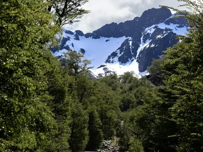
Lenga Forest Sections: The initial part of the trail winds through the beautiful lenga (Nothofagus pumilio) forests. In autumn (April-May), these forests transform into a spectacle of vibrant reds, oranges, and yellows, making the hike particularly stunning during this period. Even in summer, the dappled light filtering through the canopy creates a magical atmosphere.
Scree Slopes and Rocky Outcrops: As the trail ascends above the tree line, the landscape opens up to vast scree fields and rugged rocky formations. These areas offer a stark contrast to the forest and provide excellent opportunities to observe the geological processes that have shaped the Patagonian Andes. The texture and colour of the rocks change as you gain altitude, offering a dynamic visual experience.
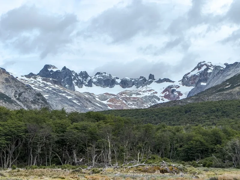
Panoramic Viewpoints: Throughout the ascent, there are numerous natural viewpoints that offer increasingly expansive vistas of the surrounding valleys, rivers, and distant peaks. These are ideal spots to pause, catch your breath, and appreciate the scale of the landscape. Keep an eye out for the iconic shapes of Mount Fitz Roy and Cerro Torre, which may become visible on clearer days as you gain elevation.
The Summit of Cerro Madsen: The ultimate point of interest is the summit itself. Reaching this exposed peak provides an unparalleled 360-degree panorama. The dominant feature is the vast Southern Patagonian Ice Field, a breathtaking expanse of ice that stretches to the horizon. You will also see numerous glacial lakes, rugged mountain ranges, and potentially other famous peaks of the region. The sense of accomplishment and the sheer beauty of the view make the arduous climb entirely worthwhile.
Wildlife Spotting: While not guaranteed, keep an eye out for Patagonian condors soaring on the thermals above the peaks. You might also spot smaller birds adapted to the alpine environment. The silence of the higher altitudes, broken only by the wind, can be profound.
Leave No Trace
The Cerro Madsen Ascent traverses a pristine natural environment within Los Glaciares National Park. Practising Leave No Trace (LNT) principles is not just recommended; it is essential to preserve this fragile ecosystem for future generations. The beauty of this trail lies in its wildness, and it is our collective responsibility to ensure it remains that way.
Your responsibility as a hiker:
- Plan Ahead and Prepare: Understand the trail, weather conditions, and any regulations before you go. Pack appropriately for all conditions.
- Travel and Camp on Durable Surfaces: Stick to the marked trail at all times. Avoid cutting switchbacks or walking on fragile vegetation, especially in the lenga forests and alpine meadows. The scree slopes are naturally durable, but avoid disturbing any established vegetation.
- Dispose of Waste Properly: Pack out everything you pack in. This includes all food scraps, wrappers, tissues, and any other litter. There are no bins on the trail. Use designated toilet facilities in El Chaltén before and after your hike. If nature calls on the trail, find a spot at least 70 metres away from water sources and the trail, dig a cathole 15-20 cm deep, and bury your waste. Pack out all toilet paper.
- Leave What You Find: Do not take rocks, plants, or any other natural objects. Leave them for others to enjoy and for the ecosystem to thrive.
- Minimise Campfire Impacts: Campfires are not permitted on this day hike. If you were to camp (which is not advised or permitted on this route), use a portable stove for cooking and ensure fires are completely extinguished.
- Respect Wildlife: Observe wildlife from a distance. Never feed animals, as it can disrupt their natural behaviours and diets. Store food securely to prevent attracting animals.
- Be Considerate of Other Visitors: Keep noise levels down, yield to other hikers, and maintain a respectful attitude. The goal is to enjoy the wilderness without disturbing others or the environment.
By adhering to these principles, you help ensure that the Cerro Madsen Ascent remains a wild and beautiful place for everyone to experience.