Uganda — Kasese
Central Circuit Rwenzori Mountains, Uganda: A 56km, 6-7 day loop through Africa's "Mountains of the Moon." This very challenging trek traverses rugged alpine terrain, ancient highland wilderness, and pristine glacial valleys. Expect demanding ascents, rocky passes, and breathtaking panoramas on this remote, otherworldly route.
Distance: 56.0 km
Elevation Gain: 4267 m
Difficulty: Very Challenging
Duration: 6-7 days
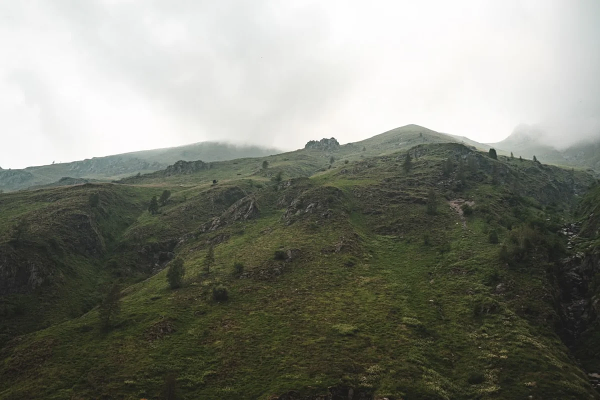
The Central Circuit in the Rwenzori Mountains is one of Africa's most demanding, rewarding, and otherworldly trekking experiences. Located on the border of Uganda and the Democratic Republic of the Congo, this 56-kilometre loop traverses the heart of the "Mountains of the Moon"—a name bestowed by the ancient Greek geographer Ptolemy, who believed these snow-capped peaks were the source of the Nile River. Unlike the volcanic peaks of Mount Kilimanjaro or Mount Kenya, the Rwenzoris are a non-volcanic range formed by the uplift of the Earth's crust, resulting in a rugged, jagged landscape of extreme verticality and profound ecological diversity. The Central Circuit is a journey through five distinct vegetation zones, from lush montane rainforests to the surreal Afro-alpine moorlands filled with giant lobelias and groundsels, culminating in the permanent glaciers of the high peaks. This is not merely a hike; it is an expedition into a prehistoric world where the weather is unpredictable, the mud is legendary, and the sense of isolation is absolute.
The Rwenzori Mountains National Park, a UNESCO World Heritage site, protects the highest mountain range in Africa. While Kilimanjaro is taller, the Rwenzoris offer a more complex and technically demanding environment. The Central Circuit is the traditional route through this wilderness, providing a comprehensive experience of the range's unique geography. The trek is famous for its "bogs"—vast, high-altitude wetlands where hikers must navigate over "bog boards" or leap between tussocks of grass. This moisture, combined with the equatorial sun, creates a greenhouse effect that fuels the growth of "botanical big game": giant heathers draped in usnea (old man's beard) lichen, and lobelias that grow to the size of trees.
The landscape pacing of the Central Circuit is relentless. Day 1 begins in the humid montane forest, where the sounds of Rwenzori turacos and blue monkeys fill the air. By Day 3, you enter the Heather-Rapanea zone, a misty, ethereal forest that feels like a scene from a fantasy novel. The upper reaches of the circuit, particularly around Lake Bujuku and the Scott-Elliot Pass, offer views of the range's three highest peaks: Mount Stanley, Mount Speke, and Mount Baker. These peaks remain capped with glaciers, though they are receding rapidly due to climate change, making a visit to this frozen equatorial world a time-sensitive endeavour.
Physicality on the Rwenzoris is defined by the terrain rather than just the altitude. The paths are often steep, slippery, and obscured by thick vegetation or deep mud. Hikers must be prepared for "vertical mud" climbing and long days of balancing on slippery roots. However, the reward is a level of biodiversity and landscape drama found nowhere else on Earth. The silence of the high valleys, broken only by the sound of rushing meltwater and the occasional call of a mountain bird, provides a profound sense of sanctuary. This is a trek for those who seek a genuine wilderness experience, far removed from the crowded trails of more famous African peaks.
The Rwenzori Mountains have been shrouded in myth for millennia. Ptolemy's 2nd-century descriptions of the "Lunae Montes" (Mountains of the Moon) remained unverified by outsiders for nearly 1,700 years. It wasn't until 1888 that the explorer Henry Morton Stanley caught a glimpse of the snow-capped peaks, finally confirming their existence to the Western world. The first successful scientific expedition to map the range and summit the major peaks was led by the Duke of Abruzzi in 1906. His team, which included the legendary mountain photographer Vittorio Sella, named many of the peaks and glaciers after European royalty and explorers, names that persist today alongside the local Bakonjo names.
For the local Bakonjo people, the mountains are the home of their primary deity, Kitasamba, who resides in the high snows. The mountains are a source of life, providing the water that feeds the surrounding plains. Traditionally, the Bakonjo used the lower slopes for hunting and gathering, but the high peaks were considered sacred and largely avoided. Today, the Bakonjo are the primary guides and porters for the Rwenzori treks, and their knowledge of the terrain and weather is indispensable. Their culture is deeply intertwined with the mountains, and many of the trail's landmarks have spiritual significance. The establishment of the National Park in 1991 and its subsequent UNESCO listing in 1994 recognised both the natural and cultural importance of this unique landscape.
Want more background? Read extended notes on history and cultural context → Learn more
The Rwenzori Mountains are notorious for their wet weather. Precipitation can occur at any time of year, and the range is often shrouded in mist and cloud. However, there are two distinct dry seasons when trekking is most feasible. The primary dry season runs from late December to February, offering the clearest skies and the best chances for summit views. The secondary dry season occurs from June to August. During these windows, the bogs are slightly more manageable, and the risk of being "rained out" is lower, though never zero.
The wet seasons (March to May and September to November) transform the trail into a series of challenging watercourses and deep mud pits. While the mountains are at their most lush and the waterfalls are at their most spectacular during these months, the technical difficulty of the trek increases significantly. High-altitude snow is common on the passes and peaks year-round, and temperatures at night frequently drop below freezing above 3,500 metres.
Weather in the Rwenzoris is highly localised. It can be sunny in the Bujuku Valley while a blizzard rages on the Elena Glacier. Hikers must be prepared for four seasons in a single day. The "Rwenzori mist" is a constant companion, creating an atmosphere of mystery but also making navigation difficult without an experienced guide. The best time to visit for photography is usually early morning, before the daily cloud cover builds up around the peaks.
Day 1: Nyakalengija to Nyabitaba Hut
Day 2: Nyabitaba Hut to John Matte Hut
Day 3: John Matte Hut to Bujuku Hut
Day 4: Bujuku Hut to Elena Hut (Summit Base)
Day 5: Elena Hut to Margherita Peak and down to Kitandara Hut
Day 6: Kitandara Hut to Guy Yeoman Hut
Day 7: Guy Yeoman Hut to Nyakalengija
Important Notes:
The Central Circuit requires significant logistical coordination. Most trekkers book through one of two primary authorised operators: Rwenzori Mountaineering Services (RMS), which manages the Central Circuit huts, or Rwenzori Trekking Services (RTS), which operates the Kilembe Route but can also facilitate Central Circuit treks. It is essential to book your trek at least 2–3 months in advance, especially during the peak dry seasons. Your operator will handle park fees, hut bookings, guides, and porters.
Physical fitness is paramount. This is not a walk on a groomed trail; it involves high-stepping over roots, balancing on slippery logs, and navigating deep mud at high altitudes. Cardiovascular training and leg strength exercises are essential. You should also be comfortable with basic rock scrambling. If you plan to summit Margherita Peak, you must have basic knowledge of using crampons and ice axes, although guides will provide on-trail instruction.
The base town for the Rwenzoris is Kasese. It is accessible from Kampala or Entebbe by a 6–7 hour drive or a short domestic flight. Kasese offers several hotels and guesthouses where you can store extra luggage and have a final hot shower before heading to the trailhead at Nyakalengija.
Accommodation on the Central Circuit consists of basic mountain huts. These are managed by Rwenzori Mountaineering Services (RMS) in partnership with the Uganda Wildlife Authority (UWA).
Hut Facilities:
What Huts Don't Provide:
Booking Requirements:
All visitors to the Rwenzori Mountains National Park must pay park entrance fees and trekking fees to the Uganda Wildlife Authority (UWA). These are almost always included in the package price provided by your trekking operator (RMS or RTS). However, it is important to understand the breakdown of these costs and the requirements for entry.
Permit and Fee Structure:
Important Documentation:
Booking Strategy: Because the Central Circuit has limited hut capacity, it is vital to secure your dates early. Once your operator confirms your booking, they will pay the necessary fees to UWA on your behalf. You will receive a briefing at the Nyakalengija park headquarters on the morning of Day 1, where your permits will be verified and you will sign the park register.

Detailed route notes, maps, logistics & tips for the Central Circuit Rwenzori Mountains (PDF).

Precisely traced GPX for the Central Circuit Rwenzori Mountains, ready for your GPS or favourite mapping app.
The Rwenzori region and Western Uganda offer numerous opportunities to extend your adventure:
Altitude Sickness: Acute Mountain Sickness (AMS) is a significant risk on the Central Circuit, as you ascend from 1,600 m to over 4,000 m in just three days. Symptoms include headache, nausea, dizziness, and fatigue. The best prevention is a slow ascent, drinking plenty of water (4–5 litres per day), and "climbing high, sleeping low." If symptoms persist or worsen into HAPE (High Altitude Pulmonary Edema) or HACE (High Altitude Cerebral Edema), immediate descent is the only cure.
Hypothermia: The combination of wet clothes, wind, and cold temperatures makes hypothermia a constant threat. Always keep a set of dry clothes in a waterproof bag for use inside the huts. Never wear cotton; stick to wool or synthetic fabrics that retain heat when wet.
Terrain Hazards: The "vertical mud" and slippery bog boards are the most common causes of injury. Use trekking poles for balance and take your time. The descent from Freshfield Pass and the "Kichuchu" rock steps are particularly taxing on the knees and require careful foot placement.
Glacier Safety: For those summiting Margherita Peak, the glaciers have deep crevasses. You must remain roped to your guide at all times. The weather on the summit plateau can change in minutes, reducing visibility to zero. Trust your guide's decision to turn back if conditions become dangerous.
Emergency Evacuation: There is no helicopter rescue available in the Rwenzoris. In the event of a serious injury or illness, the porters will carry the patient down the mountain on a "stretcher" (often a modified ladder or chair). This is a slow and arduous process, highlighting the importance of self-care and caution.
Margherita Peak (5,109 m): The ultimate side trip. While the Central Circuit is a loop, most fit trekkers add an extra day at Elena Hut to attempt the summit of Mount Stanley's highest peak. It involves crossing the Elena and Margherita glaciers and a final scramble up a steep rock face. Standing on the summit, you are on the border of Uganda and the DRC, with the vast Congo basin stretching out to the west.
Weismann's Peak (4,620 m): For those who want a high-altitude summit without the technical glacier travel of Margherita, Weismann's Peak on Mount Luigi di Savoia is a popular alternative. It offers incredible views of the Stanley massif and the Kitandara Lakes.
Lake Bujuku: This black-water lake sits at 3,962 m and is surrounded by the "Big Three" massifs. It is one of the most photogenic spots in the range. The walk around the lake through the giant groundsel forest is hauntingly beautiful.
The Bigo Bogs: While often cursed by hikers, the Lower and Upper Bigo Bogs are unique ecosystems. The sight of thousands of giant lobelias (Lobelia bequaertii) rising out of the mist is a highlight of the trek. The bog boards have made this section easier, but the scale of the wetland remains impressive.
Freshfield Pass: At 4,282 m, this pass offers a different perspective of the range, looking south towards the Edward Flats and the distant mountains of the Congo. It is a place of immense solitude and often the last high-altitude view before the long descent.
The Rwenzori Mountains are a fragile Afro-alpine ecosystem. The slow growth rates of plants at this altitude mean that damage can take decades to heal. As a UNESCO World Heritage site, it is the responsibility of every trekker to minimise their impact.
Leave No Trace Principles: