Cascade Saddle Trek (Day Section) - The Gateway to the Southern Alps
The Cascade Saddle Trek is widely regarded as one of New Zealand's most spectacular and demanding alpine crossings. While the full route connects the West Matukituki Valley with the Dart Valley, the "Day Section"—the ascent from the Matukituki Valley floor to the saddle itself—offers a concentrated dose of everything that makes the Southern Alps legendary. This 18-kilometre return journey is not a casual walk; it is a high-stakes alpine adventure that demands 1,200 metres of vertical gain over challenging, often slippery terrain. Walkers are rewarded with unparalleled views of the "Matterhorn of the South," Mount Aspiring/Tititea (3,033 m), and the sprawling ice fields of the Dart Glacier. This is a landscape of raw power, where ancient beech forests give way to steep sub-alpine tussock and eventually to the stark, wind-swept beauty of the high alpine zone. For those with the fitness and experience to tackle it, the Cascade Saddle provides a perspective on New Zealand’s wilderness that few other day hikes can match.
- Distance: 18.0 km return (from Raspberry Creek car park)
- Elevation Gain: 1,200 m
- Duration: 8–10 hours
- Difficulty: Challenging / Expert
- Best Time: December to March (summer months)
- Highest Point: Cascade Saddle (1,524 m)
- Closest City: Wanaka (approx. 1.5–2 hours drive)
- Terrain: Flat valley floor, steep beech forest, exposed alpine ridges, and rock scrambles
Overview
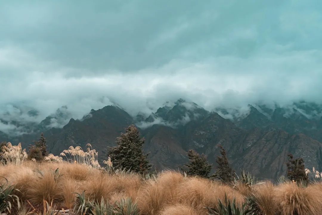
The Cascade Saddle Trek is a journey of dramatic transitions. It begins in the pastoral serenity of the West Matukituki Valley, where the Matukituki River meanders through wide, grassy flats grazed by cattle and sheep. The first few kilometres are deceptively easy, following a well-formed farm track that allows walkers to warm up while gazing at the hanging glaciers of the surrounding peaks. However, the character of the hike changes abruptly once you pass the historic Aspiring Hut. From here, the trail leaves the valley floor and plunges into a dense forest of silver beech, beginning a relentless 1,000-metre climb that rarely relents until you reach the alpine zone.
The ascent is famous for its steepness. In many sections, walkers must use tree roots as natural ladders to navigate the muddy, vertical forest floor. As the trees begin to stunt and thin, you emerge onto the sub-alpine scrub, where the views begin to open up. This is where the "Pylon" section begins—a notorious stretch of the track that traverses steep, north-facing tussock slopes. In dry conditions, it is a test of lung capacity and leg strength; in wet or icy conditions, it becomes a hazardous traverse where a slip can have serious consequences. The Pylon itself, a historic marker, serves as the gateway to the upper alpine basin.
Once above the Pylon, the gradient eases slightly as you enter a world of schist rock and alpine tarns. The final push to the saddle reveals the true prize: a 360-degree panorama that includes the shimmering Dart Glacier to the west and the formidable pyramid of Mount Aspiring/Tititea to the north. The saddle itself is a broad, often windy ridge that feels like the edge of the world. Standing here, you are surrounded by the sheer scale of the Mount Aspiring National Park, a UNESCO World Heritage area. The descent requires just as much concentration as the ascent, as the steep forest sections can be punishing on the knees and treacherous if the ground is damp. This is a hike that requires a full day of effort, a keen eye on the weather, and a deep respect for the alpine environment.
History and Cultural Context
The Matukituki Valley and the surrounding peaks hold deep significance for Māori, particularly the Ngāi Tahu iwi. For centuries, these valleys served as seasonal routes for gathering resources and as passages for those travelling to the West Coast in search of pounamu (greenstone). The name Matukituki refers to the "thumping" or "pounding" sound of the river, a testament to the power of the glacial meltwater that carves through the landscape. To Māori, the mountains are more than just physical landmarks; they are ancestors, and Mount Aspiring/Tititea (meaning "steep peak of glistening white") is a sacred presence that dominates the spiritual and physical geography of the region.
European history in the valley is closely tied to the early days of New Zealand mountaineering and pastoral farming. The West Matukituki was first surveyed by Europeans in the mid-19th century, and by the late 1800s, high-country runs were established. The Raspberry Creek area, where the trailhead is located, remains an active farming operation today, reflecting the long-standing tradition of New Zealand's "backcountry" economy. The New Zealand Alpine Club (NZAC) has a storied connection to this area; they built the original Aspiring Hut in 1949 to serve as a base for climbers attempting the surrounding peaks. The hut has since been upgraded but remains a symbol of the golden age of New Zealand exploration.
The Cascade Saddle route itself was pioneered by early explorers and climbers looking for a direct link between the Matukituki and Dart catchments. Unlike the more groomed Great Walks, the Cascade Saddle track has retained its rugged, "tramper's track" character. It was never intended to be a high-volume tourist route, and its history is marked by the stories of those who sought the ultimate alpine challenge. The inclusion of the area in the Te Wāhipounamu World Heritage site in 1990 recognised its global importance, ensuring that the pristine nature of the saddle and its surrounding glaciers is preserved for future generations.
Want more background? Read extended notes on history and cultural context → Learn more
Seasonal Highlights and Weather Reality
The Cascade Saddle is a strictly seasonal objective. Due to its elevation and the steepness of the "Pylon" section, the trek is only recommended for general trampers during the summer and early autumn months (December to March). Even during this window, the weather in the Southern Alps is notoriously fickle and can change from bluebird skies to a life-threatening storm in less than an hour.
Summer (December to February): This is the prime window. The days are long, with daylight lasting until 9:30 PM, providing a safety margin for the long 10-hour return trip. The alpine flowers, including the iconic Mount Cook Lily (Ranunculus lyallii), are in bloom, and the tarns on the upper ridge are usually clear of ice. However, heat can be an issue on the exposed tussock slopes, and the "Pylon" section can become very dusty and slippery. Afternoon thunderstorms are a common occurrence and should be monitored closely.
Autumn (March to April): March offers stable weather and cooler temperatures, which can make the 1,200-metre climb more comfortable. The light in autumn is exceptionally clear, making for world-class photography. By April, however, the risk of early-season snow increases, and the days shorten significantly. Frost can make the rock sections near the saddle extremely slick in the early morning.
Winter and Spring (May to November): During these months, the Cascade Saddle is the domain of experienced mountaineers only. The "Pylon" section becomes a lethal slide of snow and ice, and the avalanche risk in the upper basins is high. Bridges in the valley may be removed to prevent avalanche damage, and the track is often obscured. Unless you are equipped with ice axes, crampons, and the knowledge of how to use them, the saddle is inaccessible during this period.
Regardless of the season, the "Weather Reality" of the Matukituki Valley is that it sits in the path of the "Roaring Forties." Strong westerly winds can make standing on the saddle impossible, and heavy rain can turn the forest section into a mudslide. Always check the high-altitude forecast before leaving Wanaka.
Recommended Itinerary
Cascade Saddle Day Trek Itinerary
Early Morning: The Valley Approach
- 07:00 – Depart Wanaka for the 1.5-hour drive to Raspberry Creek car park. The road includes several fords; check conditions if there has been recent rain.
- 08:30 – Begin the walk from Raspberry Creek. The first 5 km is a flat, easy stroll through the West Matukituki Valley.
- 09:30 – Reach Aspiring Hut. This is the last reliable place for treated water and a proper toilet. Take a short break and ensure your gear is ready for the climb.
- Key Waypoints: Raspberry Creek Carpark, Ninemile Creek, Aspiring Hut.
Morning: The Great Ascent
- 10:00 – Leave Aspiring Hut and enter the beech forest. The track immediately steepens.
- 10:00–12:00 – The "Root Ladder" climb. Navigate the 800-metre vertical gain through the forest. This section is physically demanding and requires steady pacing.
- 12:00 – Emerge from the bushline. The views of the Matukituki Valley open up spectacularly.
- Key Waypoints: Bushline, start of the alpine tussock.
Midday: The Pylon and the Saddle
- 12:00–13:30 – Traverse the "Pylon" section. This is the most exposed part of the hike. Follow the orange poles carefully through the steep tussock.
- 13:30 – Reach the Pylon (a historic iron marker). From here, the gradient levels out as you enter the upper basin.
- 14:00 – Arrive at Cascade Saddle (1,524 m). Spend time exploring the ridge to see the Dart Glacier and Mount Aspiring/Tititea.
- Key Waypoints: The Pylon, Cascade Saddle, Dart Glacier viewpoint.
Afternoon: The Descent
- 14:30 – Begin the descent. Extreme care is needed on the Pylon section; many accidents occur here due to fatigue.
- 16:00 – Re-enter the forest. The descent through the roots is slow and requires concentration to avoid ankle injuries.
- 17:30 – Return to Aspiring Hut. Refill water and take a moment to rest your legs.
- 17:30–18:30 – The final flat walk back to Raspberry Creek car park.
- 19:00 – Arrive back at the car for the drive back to Wanaka.
Important Notes:
- This itinerary assumes a high level of fitness and good weather conditions.
- There is no water available between Aspiring Hut and the alpine tarns near the saddle; carry at least 2–3 litres.
- The "Pylon" section is dangerous in the rain; if it starts to pour, turn back immediately.
- Ensure you have a head torch in case the descent takes longer than planned.
Planning and Bookings
Book Your Trip
Everything you need to plan your journey
Accommodation
Find places to stay near Wanaka
Flights
Search flights to Wanaka
Essential Preparation
The Cascade Saddle Day Trek requires significant physical and logistical preparation. Unlike the Great Walks, there is no transport service that drops you at the trailhead; you will need a private vehicle or a pre-arranged shuttle from Wanaka. The drive from Wanaka to Raspberry Creek takes approximately 1.5 to 2 hours, and the final 30 kilometres are on a gravel road with several fords (stream crossings). While usually passable in a standard car, these fords can become impassable after heavy rain. Always check the road status with the Wanaka DOC Visitor Centre before heading out.
Fitness is the most critical preparation. You must be comfortable with a 1,200-metre vertical gain and loss in a single day. This is equivalent to climbing the Empire State Building three times over, on uneven and often slippery terrain. Training on steep hills or stairs with a weighted pack is highly recommended. Additionally, you should be comfortable with "exposure"—sections of the track where there are steep drops nearby.
Trail Accommodation
As this is a day hike description, no overnight stay is required on the track itself. However, many walkers choose to stay at Aspiring Hut to break up the journey or to get an earlier start on the climb.
Aspiring Hut (DOC/NZAC):
- Facilities: 38 bunks, mattresses, gas cookers (summer only), wood burner, toilets, and non-treated water.
- Booking: Mandatory during the peak season (late October to April) via the DOC website.
- Cost: Approximately NZ$40 per night for adults.
- Note: You must bring your own sleeping bag and cooking utensils.
Camping:
- Camping is permitted on the valley floor, but you must be at least 200 metres away from the track and Aspiring Hut.
- There is no camping allowed on the Cascade Saddle itself or in the fragile alpine basins above the bushline to protect the environment.
Required Gear
- Footwear: Sturdy tramping boots with excellent grip are non-negotiable. The forest section is often muddy, and the alpine rock is sharp.
- Clothing: Layering is key. Bring a breathable base layer (merino), an insulating mid-layer (fleece or down), and a high-quality waterproof shell jacket. Even in summer, temperatures at the saddle can drop to near freezing.
- Navigation: A topographic map (NZTopo50-CA11) and a compass, or a reliable GPS/offline map app. The track is marked with orange poles, but visibility can drop rapidly in cloud.
- Safety: A Personal Locator Beacon (PLB) is highly recommended, as there is no mobile phone coverage in the Matukituki Valley or on the saddle.
- Sun Protection: High-SPF sunscreen, sunglasses, and a hat. The alpine sun in New Zealand is exceptionally strong due to low pollution and a thin ozone layer.
What to Bring
- Water: At least 2–3 litres per person. The climb is strenuous and dehydrating. Water from the valley streams should be treated (boiled or filtered).
- Food: High-energy snacks (nuts, chocolate, dried fruit) and a substantial lunch. You will burn a significant number of calories on the 1,200-metre climb.
- Emergency Kit: A basic first aid kit (including blister pads), an emergency foil blanket, and a whistle.
- Head Torch: Even if you plan to be back by daylight, a head torch is an essential safety item in case of delays.
- Trash Bag: To pack out all your waste, including organic scraps like apple cores or banana peels.
Permits
For day walkers, no permits or fees are required to hike to Cascade Saddle. You are free to access the Mount Aspiring National Park at any time. However, there are several administrative and safety "checks" you should perform before starting.
Intentions: It is vital to leave your intentions with a trusted contact or use the "Plan My Walk" app by the NZ Mountain Safety Council. Tell someone exactly when you are starting, your intended route, and when you expect to be back. There is no formal sign-in book at the trailhead.
Hut Bookings: If you plan to stay overnight at Aspiring Hut before or after your trek, you must book this in advance through the Department of Conservation (DOC) online booking system. During the summer months, the hut frequently reaches capacity, and "walk-ins" are not guaranteed a bed.
Parking: Parking at the Raspberry Creek car park is free, but it can fill up quickly during the peak summer season. Ensure you park within the designated areas to allow farm vehicles and emergency services to pass. Do not leave valuables in your vehicle, as trailhead thefts, while rare, can occur in remote areas.
Access via Private Land: The first section of the walk passes through an active working farm (Mount Aspiring Station). Access is granted by the landowners, provided walkers stay on the marked track and do not disturb livestock. There are no fees for this access, but it is a privilege that relies on hikers being respectful.
Other Activities in the Area
The Wanaka and Matukituki region is a hub for outdoor enthusiasts. If you have extra time, consider these nearby attractions:
- Rob Roy Glacier Track: A stunning 3–4 hour return walk that starts from the same car park as the Cascade Saddle. It offers spectacular views of hanging glaciers and waterfalls with much less effort than the saddle.
- Wanaka Lakefront: After a long hike, the shores of Lake Wanaka are perfect for a swim or a relaxing meal. Don't miss the famous "That Wanaka Tree" for a classic photo opportunity.
- Blue Pools: Located near Makarora (about an hour from Wanaka), these crystal-clear glacial pools are a must-see for their incredible turquoise colour.
- Rock Climbing: The Matukituki Valley and the nearby Hospital Flat are world-renowned for their schist rock climbing, offering routes for all skill levels.
- Via Ferrata: For those who want more vertical excitement, the "Wildwire" waterfall climb in Wanaka offers a guided cable-climb up a massive waterfall face.
- Wine Tasting: Central Otago is famous for its Pinot Noir. Several award-winning wineries are located just a short drive from Wanaka.
Safety and Conditions
The "Pylon" Hazard: The section between the bushline and the Pylon is the most dangerous part of the trek. It consists of steep, slippery tussock slopes that can be lethal if wet. There have been several fatalities on this section over the years, usually involving slips in damp conditions. If the grass is wet from rain or morning dew, the risk of a long, uncontrolled slide is high. Do not attempt this section if it is raining or if the ground is saturated.
Weather Volatility: Mount Aspiring National Park is subject to rapid weather changes. Cloud can descend on the saddle in minutes, reducing visibility to a few metres. If you lose sight of the orange marker poles, stop and wait for a break in the cloud or carefully retrace your steps. Hypothermia is a genuine risk even in summer if you are caught in the rain at 1,500 metres without adequate clothing.
River Crossings: While the main track to Aspiring Hut is mostly bridged, the road to the car park involves fords. After heavy rain, these fords can rise rapidly, potentially stranding your vehicle at the car park. Always check the rainfall forecast and be prepared to wait for water levels to drop.
Kea Interaction: You are likely to encounter Kea (New Zealand's alpine parrot) at the saddle. While they are charismatic and curious, they are also highly destructive. Do not leave your pack unattended, as they can tear through fabric and zips in seconds. Never feed them, as human food is harmful to their health and encourages aggressive behaviour.
Physical Fatigue: The 1,200-metre descent is often where injuries occur. Tired legs lead to stumbles. Take frequent short breaks on the way down and use trekking poles if you have them to reduce the impact on your knees.
Side Trips and Points of Interest
The Dart Glacier Viewpoint: Once you reach the Cascade Saddle, don't just stop at the first flat spot. Walk a few hundred metres further west along the ridge. The ground drops away to reveal the massive Dart Glacier and the headwaters of the Dart River. The scale of the ice and the deep blue of the crevasses are breathtaking.
The Pylon: This historic iron pylon was installed decades ago to help guide trampers. It serves as a great landmark and a psychological milestone. Reaching the Pylon means the hardest part of the climb is over, and you have entered the true alpine zone.
Mount Aspiring/Tititea Views: From the saddle, you have one of the best "non-climbing" views of Mount Aspiring. Its distinctive pyramid shape has earned it the nickname "The Matterhorn of the South." On a clear day, you can see climbers on the distant ridges and the vast Bonar Glacier shimmering in the sun.
Alpine Tarns: The upper basin near the saddle is dotted with small alpine tarns (lakes). These are incredibly still and provide perfect reflections of the surrounding peaks. They are also home to unique alpine flora and fauna, including the mountain buttercup.
Leave No Trace
The alpine environment of the Cascade Saddle is extremely fragile. The plants that grow here, such as the cushion plants and alpine tussocks, take decades to grow just a few centimetres. A single misplaced footstep can cause damage that lasts for years. Please follow these principles strictly:
- Stay on the Track: Even when it's muddy, stay on the formed path or the rock. Braiding the track (walking on the edges) destroys the surrounding vegetation and causes erosion.
- Pack It In, Pack It Out: This includes all rubbish, food scraps, and even fruit peels. Organic waste does not decompose quickly in the cold alpine environment and can attract pests.
- Respect Wildlife: Observe Kea and other birds from a distance. Do not feed them or try to touch them.
- Toilet Etiquette: Use the toilets at Raspberry Creek or Aspiring Hut before you start the climb. If you are caught short in the alpine zone, you must carry out your waste using a "poo tube" or similar system, as the thin soils cannot process human waste.
- Leave What You Find: Do not pick alpine flowers or remove rocks. Leave the landscape exactly as you found it for the next person to enjoy.