Carnedd Llewelyn via Cwm Lloer
The Carneddau range in Snowdonia, North Wales, offers some of the most rugged and rewarding mountain walking in the United Kingdom. Carnedd Llewelyn, at 1,064 metres, is the second-highest peak in Snowdonia and the highest in this particular massif. The ascent via Cwm Lloer presents a challenging yet spectacular route, taking walkers through a dramatic glacial valley to a summit offering panoramic views across the national park and beyond.
This route is not for the faint-hearted. It demands good fitness, navigation skills, and appropriate gear, especially given the unpredictable Welsh mountain weather. The path can be indistinct in places, particularly in the upper reaches of Cwm Lloer, and the final push to the summit requires careful footing over scree and rock. However, the reward is immense: a true wilderness experience, a sense of accomplishment, and breathtaking vistas that stretch to the Irish Sea on a clear day.
- Distance: 14.0 km
- Elevation Gain: 950 m
- Duration: 5-6 hours
- Difficulty: Challenging
- Best Time: April-October
- Closest City: Bangor
- Trailhead Access: Nearest city: Bangor. Drive A5 to Ogwen Cottage. Parking available (pay & display). Limited bus service. From Bangor, approx. 20-30 min drive. Road conditions generally good. No permits required.
Overview
The Carnedd Llewelyn via Cwm Lloer route is a classic Snowdonia mountain challenge. It begins from the popular Ogwen Valley, a hub for climbers and walkers, and immediately plunges into the wild beauty of Cwm Lloer. This is a substantial glacial valley, carved by ancient ice, and its steep sides and dramatic rock formations set the tone for the day.
The initial section of the walk follows a clear path, but as you ascend into the cwm, the terrain becomes rougher and the path less defined. You'll navigate across boulder fields and scree slopes, with the imposing bulk of Carnedd Llewelyn and its neighbours looming above. The ascent is relentless, gaining over 900 metres of elevation, which will test your stamina and leg strength.
The summit of Carnedd Llewelyn is a broad, rocky plateau. On a clear day, the views are simply outstanding. To the west, you can see the Glyderau range, including Tryfan and the Glyderau peaks. To the north, the coastline stretches out towards Anglesey and the Irish Sea. To the east and south, the vast expanse of the Carneddau range unfolds, with peaks like Carnedd Dafydd and Foel Grach dominating the skyline. The descent, often via a similar route or a slight variation, requires careful attention to avoid slips and stumbles on the loose ground.
This walk is best undertaken in good weather conditions. Fog, rain, or strong winds can make navigation extremely difficult and significantly increase the risk of the route becoming hazardous. It offers a genuine sense of remoteness and wildness, a stark contrast to the more popular routes on Snowdon itself.
History and Cultural Context
The Carneddau mountains have a long and rich history, intertwined with the lives of the people who have inhabited this region of North Wales for millennia. The name "Carneddau" itself means "cairns" in Welsh, a testament to the ancient burial mounds that dot the landscape, particularly on the lower slopes and plateaus. These prehistoric monuments speak of early human settlement and spiritual practices dating back to the Neolithic period.
Carnedd Llewelyn is named after Llywelyn ap Gruffudd, the last native Prince of Wales, who was a significant figure in Welsh history during the 13th century. His resistance against English expansion culminated in his defeat and death in 1282, marking a pivotal moment in the subjugation of Wales. The mountain, therefore, carries a name imbued with nationalistic and historical significance, a symbol of Welsh identity and past sovereignty.
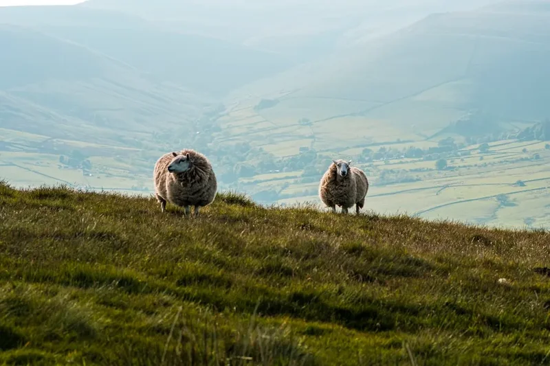
In more recent centuries, the Carneddau were primarily the domain of shepherds and sheep farmers. The hardy Welsh mountain sheep, adapted to the harsh conditions, have grazed these slopes for generations, shaping the landscape through their grazing. The paths that walkers now follow often originated as ancient drovers' routes or sheep tracks, worn smooth by centuries of footfall.
The Ogwen Valley, the starting point for this route, has also been a focal point for exploration and adventure. It became a popular area for early mountaineers and climbers in the late 19th and early 20th centuries, drawn by the challenging terrain and dramatic rock formations. The establishment of Ogwen Cottage as a mountain rescue base and outdoor education centre further cemented its status as a gateway to the wild heart of Snowdonia.
Seasonal Highlights and Weather Reality
The best time to tackle Carnedd Llewelyn via Cwm Lloer is generally from April to October. During these months, the days are longer, and the weather is typically more favourable for mountain walking.
Spring (April-May): The landscape begins to reawaken. Wildflowers may start to appear on the lower slopes, and the air can be crisp and clear. However, snow can linger on the higher ground, especially in shaded gullies, and early spring weather can still be unpredictable, with cold snaps and potential for snow showers. Navigation can be tricky if snow covers the paths.
Summer (June-August): This is the most popular season for mountain walking. Days are at their longest, offering ample daylight for the ascent and descent. The weather is generally warmer, though mountain thunderstorms are a significant risk and can develop rapidly. The higher ground can be dry, but water sources may be less abundant. Sandflies can be a nuisance in sheltered, damp areas, though less so than in some other UK mountain regions.
Autumn (September-October): The autumn colours can be spectacular, with the heather and bracken turning shades of russet and gold. The air is often clear and crisp, offering excellent visibility. However, daylight hours decrease, and the weather can become more unsettled, with increased chances of rain, wind, and early snow. The paths can become slippery with wet leaves and damp ground.
Winter (November-March): This route is generally not recommended for inexperienced walkers during winter. The higher sections of Cwm Lloer and the summit plateau can be covered in deep snow and ice, requiring specialist winter mountaineering equipment (ice axe, crampons) and advanced navigation skills. Conditions can change rapidly, and avalanche risk is a serious consideration. Even in milder winter conditions, the reduced daylight hours and potential for severe weather make it a challenging undertaking.
Weather Reality: It cannot be stressed enough that mountain weather in Snowdonia is notoriously changeable. Even on a seemingly clear summer day, conditions can deteriorate rapidly. Always check the mountain forecast (e.g., MetOffice Mountain Forecast, MWIS) before setting out and be prepared for wind, rain, mist, and cold temperatures at any time of year.
Recommended Itinerary
Carnedd Llewelyn via Cwm Lloer - Day Hike Itinerary
Early Morning (Approx. 8:00 AM): Arrival and Preparation
- Arrive at Ogwen Cottage car park (pay & display).
- Ensure you have all necessary gear, including waterproofs, warm layers, food, water, and navigation equipment.
- Check the latest mountain weather forecast if possible.
- Briefly familiarise yourself with the route and potential hazards.
Morning (Approx. 8:30 AM - 12:30 PM): Ascent into Cwm Lloer
- Start from Ogwen Cottage, heading west along the A5 briefly before taking the path signposted towards Cwm Lloer.
- The initial section is a well-trodden path, gradually ascending.
- Enter Cwm Lloer. The path becomes rougher, involving boulder fields and scree.
- Navigate carefully, keeping the steep valley walls to your sides. The objective is to gain height steadily within the cwm.
- Elevation gain: Approx. 600-700 metres.
- Distance covered: Approx. 5-6 km.
- Time taken: Approx. 3-4 hours.
Midday (Approx. 12:30 PM - 1:30 PM): Summit Approach and Lunch
- As you approach the head of Cwm Lloer, the terrain becomes steeper and more rugged.
- The path may become indistinct; use your map and compass to maintain your bearing towards the saddle or the summit ridge.
- Find a sheltered spot to take a break and have lunch, ideally before the final push to the summit.
- The summit of Carnedd Llewelyn is a broad plateau, and identifying the highest point requires careful observation.
- Elevation gain: Approx. 250-350 metres from the head of the cwm.
- Distance covered: Approx. 1-2 km.
- Time taken: Approx. 1-1.5 hours.
Afternoon (Approx. 1:30 PM - 4:30 PM): Summit and Descent
- Reach the summit of Carnedd Llewelyn (1,064 m). Enjoy the panoramic views (weather permitting).
- Spend time at the summit, but be mindful of the weather and daylight hours.
- Begin your descent. The most common route is to retrace your steps back down Cwm Lloer.
- Exercise extreme caution on the scree and boulder fields during the descent, as it is easy to slip.
- Elevation loss: Approx. 950 metres.
- Distance covered: Approx. 7-8 km.
- Time taken: Approx. 2-3 hours.
Late Afternoon (Approx. 4:30 PM onwards): Return to Ogwen Cottage
- Continue descending from the mouth of Cwm Lloer back towards the A5 and Ogwen Cottage.
- Arrive back at the car park, having completed a challenging and rewarding mountain ascent.
Important Notes:
- This is a challenging mountain walk. Ensure you are fit enough and have appropriate experience.
- Navigation skills are essential, especially in poor visibility.
- Always carry a map, compass, and the means to navigate (GPS device or smartphone with offline maps).
- Be prepared for rapid weather changes.
- Carry sufficient food and water for the duration of the walk.
- Inform someone of your route and expected return time.
Planning and Bookings
Book Your Trip
Everything you need to plan your journey
Accommodation
Find places to stay near Bangor
Flights
Search flights to Bangor
Essential Preparation
This route requires thorough preparation due to its challenging nature and potential for difficult weather. Begin by assessing your fitness levels; a good level of cardiovascular endurance and leg strength is necessary to cope with the sustained ascent and descent over rough terrain. Familiarise yourself with map reading and compass skills, as visibility can be poor, and the path can be indistinct in places.
The closest major city is Bangor, which offers a good base for pre- or post-hike accommodation and supplies. From Bangor, the A5 road provides direct access to the Ogwen Valley. The drive typically takes 20-30 minutes. Parking is available at Ogwen Cottage, but it is a popular spot, especially on weekends and during peak season, so arriving early is advisable. There is a pay-and-display system in operation.
Public transport options are limited but exist. Bus services run along the A5, connecting Bangor to the Ogwen Valley. Check local bus timetables for the most up-to-date information, as services can be infrequent, particularly outside of peak tourist times.
Trail Accommodation
This is a day hike requiring no overnight accommodation. The route is designed to be completed within a single day, starting and finishing at the Ogwen Valley. Walkers should plan to stay in nearby towns such as Bangor, Bethesda, or Llanberis for accommodation before and after their hike.
Required Gear
- Sturdy walking boots: Waterproof, with good ankle support and a well-worn sole for grip on rough terrain.
- Waterproof jacket and trousers: Essential for protection against rain and wind. Ensure they are breathable.
- Warm layers: Including a fleece or insulated jacket, and a base layer made of merino wool or synthetic material. Avoid cotton.
- Hat and gloves: Even in summer, the summit can be cold and windy.
- Backpack: A comfortable day pack (25-35 litres) to carry essentials.
- Navigation equipment: A detailed map of the area (e.g., Ordnance Survey Explorer OL17 Snowdon), a compass, and ideally a GPS device or smartphone with offline mapping capabilities. Know how to use them.
- Head torch: With spare batteries, in case of unexpected delays or early starts/late finishes.
- First-aid kit: Including blister plasters, bandages, antiseptic wipes, pain relievers, and any personal medication.
- Sun protection: Sunscreen, sunglasses, and a sun hat, even on cloudy days, as UV radiation can be strong at altitude.
What to Bring
- Food: High-energy snacks (nuts, dried fruit, energy bars), sandwiches, and a packed lunch.
- Water: At least 2 litres per person. Water sources may be available in Cwm Lloer, but it is advisable to treat or filter any water collected from streams.
- Water treatment: Water filter or purification tablets as a backup.
- Mobile phone: Fully charged, for emergencies. Note that signal can be intermittent in the mountains.
- Emergency shelter: A lightweight emergency bivvy bag or survival blanket.
- Whistle: For signalling in an emergency.
- Trekking poles: Optional, but can aid stability and reduce strain on knees, especially during the descent.
- Small trowel and toilet paper: For emergencies if away from designated facilities (pack out all used toilet paper).
Permits
No specific permits are required to walk to Carnedd Llewelyn via Cwm Lloer. This is a public mountain path within the Snowdonia National Park, and access is generally free. However, standard regulations for national parks apply, such as adhering to the Countryside Code and respecting the environment.
Parking: While access to the mountain is free, parking at Ogwen Cottage is subject to a pay-and-display charge. Ensure you have appropriate change or a payment method accepted by the machine.
Conservation: While no permits are needed, walkers are expected to practice responsible outdoor recreation. This includes staying on marked paths where possible, not disturbing wildlife, and taking all litter home. The area is a Site of Special Scientific Interest (SSSI) and part of a UNESCO World Heritage Site, highlighting its ecological and cultural importance.
Other Activities in the Area
The Ogwen Valley and surrounding areas offer a wealth of activities for outdoor enthusiasts:
- Climbing and Bouldering: The crags around Cwm Idwal and the Glyderau are world-renowned for climbing.
- Hiking and Mountaineering: Numerous other peaks and routes are accessible from the Ogwen Valley, including Tryfan, Glyder Fach, Glyder Fawr, and the neighbouring Carnedd Dafydd.
- Cwm Idwal National Nature Reserve: A beautiful and geologically significant valley with a stunning lake, accessible via a well-maintained path from Ogwen Cottage. It's a great option for a less strenuous walk.
- Llyn Ogwen: The lake itself offers scenic views and opportunities for photography.
- Zip World: Located nearby in Bethesda, offering thrilling zip-lining experiences.
- National Slate Museum: In Llanberis, providing insight into the region's industrial heritage.
- Snowdon Mountain Railway: From Llanberis, a scenic train journey to the summit of Snowdon.
Safety and Conditions
Weather: The most significant safety consideration is the unpredictable mountain weather. Always check the MetOffice Mountain Forecast or Mountain Weather Information Service (MWIS) for Snowdonia before you go. Be prepared for rapid changes, including wind, rain, mist, and even snow at higher altitudes, regardless of the season.
Navigation: The path through Cwm Lloer can be indistinct, especially in poor visibility. Carry a map and compass and know how to use them. Do not rely solely on GPS devices, as batteries can fail, and signal can be lost.
Terrain: The route involves rough, uneven ground, including boulder fields and scree slopes. These can be unstable and slippery, particularly when wet. Take your time, watch your footing, and use trekking poles if you have them.
Fitness: This is a strenuous walk with significant elevation gain. Ensure you are physically fit enough to complete the route comfortably and safely. If you are unsure, consider a less demanding walk.
Emergencies: In case of an emergency, dial 999 or 112 and ask for Mountain Rescue. Provide your location as accurately as possible. It is advisable to have a fully charged mobile phone, but be aware that signal can be unreliable in the mountains.
Inform Someone: Always let a friend or family member know your planned route, your expected return time, and who to contact if you do not check in.
Water: Carry sufficient water, as there are few reliable water sources on the upper mountain. If you plan to refill from streams, use a water filter or purification tablets.
Keenness: The summit plateau of Carnedd Llewelyn is exposed and can be very windy. Be prepared for these conditions and do not linger too long if the weather is deteriorating.
Side Trips and Points of Interest
Cwm Idwal: While not a side trip in the traditional sense, the path into Cwm Idwal branches off near the start of the Cwm Lloer route. Cwm Idwal is a stunning National Nature Reserve, famous for its glacial features, including the Idwal Slabs (a popular climbing venue) and the picturesque Llyn Idwal. It offers a gentler, more accessible introduction to the dramatic landscapes of the Ogwen Valley.
Devil's Kitchen (Twll Du): This is a dramatic, jagged gash in the mountainside at the head of Cwm Idwal, leading up towards Glyder Fawr. While not directly on the Cwm Lloer route to Carnedd Llewelyn, it is a prominent landmark visible from the valley and a challenging scramble for experienced individuals. It's a place of legend and a striking geological feature.
The Carneddau Ridge: For experienced and well-equipped walkers, the ridge connecting Carnedd Llewelyn to its neighbours, Carnedd Dafydd and Foel Grach, offers further exploration. This is a more serious undertaking, requiring excellent navigation and mountain sense, especially in poor weather.
Prehistoric Cairns: Keep an eye out for the numerous ancient burial cairns scattered across the lower slopes and plateaus of the Carneddau. These are important archaeological sites and a reminder of the long human history of this landscape.
Leave No Trace
The Carneddau, like all mountain environments, is a fragile ecosystem that requires respect and careful stewardship. Practising Leave No Trace principles ensures that these wild places remain beautiful and accessible for future generations.
Plan Ahead and Prepare: Understand the route, weather conditions, and potential hazards before you go. Pack appropriately for the conditions.
Travel and Camp on Durable Surfaces: Stick to the established paths and trails. Avoid walking on fragile vegetation, especially mosses and lichens, which can take a very long time to recover.
Dispose of Waste Properly: Pack out everything you pack in. This includes all litter, food scraps, and anything else you bring into the mountains. If you need to go to the toilet, do so well away from water sources and paths, and bury human waste deeply. Pack out used toilet paper.
Leave What You Find: Do not disturb or remove any natural or cultural objects. Leave rocks, plants, and other natural items as you find them.
Minimise Campfire Impacts: Campfires are generally not permitted in the mountains, and this route is a day hike anyway. If camping were permitted, use established fire rings and keep fires small.
Respect Wildlife: Observe wildlife from a distance. Do not feed animals, as this can disrupt their natural behaviour and diet. The Welsh mountain ponies and sheep are accustomed to people but should not be approached or fed.
Be Considerate of Other Visitors: Keep noise levels down, especially in quieter areas. Yield to other walkers on narrow paths. Respect the peace and tranquility of the mountains.