Cape Wrath Trail (Coastal Segments) - Britain’s Wildest Frontier
The Cape Wrath Trail (Coastal Segments) represents the pinnacle of British long-distance trekking, a formidable 320-kilometre odyssey through the most remote and rugged landscapes of the Scottish Highlands. Unlike the well-trodden and waymarked paths of the south, this route is an unofficial, unmarked challenge that demands high-level navigational competence, physical resilience, and an adventurous spirit. Stretching from the dramatic cliffs of the northeast near Duncansby Head and winding westward across the roof of Scotland to the iconic Cape Wrath lighthouse, the trail traverses a land of vast peat bogs, towering sea cliffs, and deep, glaciated glens. This is not merely a walk; it is a sustained expedition through a wilderness where the weather is a primary protagonist and the Atlantic Ocean provides a constant, roaring soundtrack. For those who seek to escape the modern world, the coastal segments of the Cape Wrath Trail offer a profound sense of isolation and a raw connection to the elements that is increasingly rare in Western Europe.
- Distance: 320.0 km
- Elevation Gain: 12,000 m
- Duration: 20–25 days
- Difficulty: Very Challenging
- Best Time: May to September (weather dependent)
- Closest City: Inverness
- Trailhead: Duncansby Head / Wick
- Finishing Point: Cape Wrath Lighthouse
- Navigation: Unmarked; map and compass skills essential
Overview
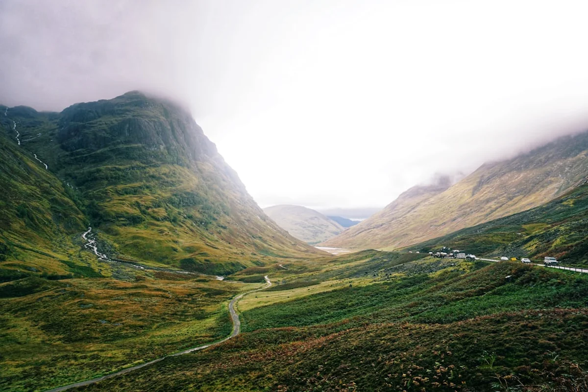
The Cape Wrath Trail is frequently cited as the toughest hiking route in the United Kingdom. While the traditional route often begins in Fort William, the Coastal Segments focus on the northernmost reaches of the Scottish mainland, hugging the jagged coastline of Sutherland and Caithness. This 320-kilometre journey is a masterclass in geological diversity and wilderness immersion. The trail begins at the northeastern tip of Scotland, where the North Sea meets the Atlantic, and proceeds westward through the "Flow Country"—one of the world's last great wildernesses and a vast expanse of blanket bog that tests the resolve of even the most seasoned hikers. As the route moves west, the landscape transforms from the rolling peatlands of the east into the dramatic, shattered mountains of the Northwest Highlands, where ancient Lewisian gneiss and Torridonian sandstone form some of the oldest rock formations on Earth.
What distinguishes this trail from others is the total absence of official waymarking. There are no fingerposts pointing the way to Cape Wrath, and no groomed gravel paths to follow. Instead, walkers must rely on their ability to read the terrain, interpret Ordnance Survey maps, and navigate through frequent mists and driving rain. The "path" is often nothing more than a deer track or a faint indentation in the heather, which can vanish entirely into a saturated bog or a boulder field. The elevation gain of 12,000 metres is not achieved through a single mountain pass, but through a relentless "sawtooth" profile of coastal ascents and descents, crossing sea lochs, and traversing high moorland plateaus.
The rewards, however, are commensurate with the effort. Walkers will experience the haunting beauty of Sandwood Bay—often called the most beautiful beach in Britain—and the stark, end-of-the-world atmosphere of the Cape Wrath lighthouse. The wildlife is equally spectacular; golden eagles soar over the glens, red deer roam the hillsides, and grey seals frequent the rocky coves. This is a journey for those who find beauty in the bleak, strength in the struggle, and peace in the profound silence of the Scottish Highlands.
History and Cultural Context
The history of the land traversed by the Cape Wrath Trail is one of resilience, tragedy, and transformation. For centuries, these coastal glens were home to vibrant Gaelic-speaking communities. However, the 18th and 19th centuries saw the devastating period known as the Highland Clearances. Landowners, seeking to make the land more profitable through large-scale sheep farming, forcibly evicted thousands of crofters from their ancestral homes. As you walk the trail, you will frequently encounter "lazy beds" (ancient cultivation ridges) and the roofless stone ruins of "clachans" (small villages), silent witnesses to a vanished way of life. The sense of emptiness in the landscape today is not entirely natural; it is a cultural landscape shaped by this forced depopulation.
The name "Cape Wrath" itself carries a historical misunderstanding. While it perfectly describes the "wrathful" storms that batter the headland, the name actually derives from the Old Norse word "hvarf," meaning "turning point." For the Viking voyagers who dominated these coasts a millennium ago, Cape Wrath was the point where they turned their longships south toward the Hebrides and the Irish Sea. The influence of the Norsemen remains etched in the place names of the region—names ending in "-boll" (farm) or "-dale" (valley) are common throughout Sutherland.
In more recent history, the Cape Wrath area has been shaped by the military. Since the early 20th century, the Ministry of Defence (MOD) has used the Parph (the moorland surrounding the Cape) as a live-fire bombing range. This has created a strange paradox: while the area is technically a military zone, the lack of commercial development or permanent habitation has preserved it as one of the most pristine ecosystems in the UK. The trail as a recognised hiking route was first popularised by David Paterson in the 1990s, and it has since become a "bucket list" expedition for serious trekkers worldwide, representing the ultimate test of British hillwalking skills.
Want more background? Read extended notes on history and cultural context → Learn more
Seasonal Highlights and Weather Reality
The weather in the Northwest Highlands is notoriously fickle, influenced by the North Atlantic Drift and the mountainous topography. Planning your journey around the seasons is critical for both safety and enjoyment.
Spring (May to June): This is widely considered the "golden window" for the Cape Wrath Trail. Statistically, these months are the driest and sunniest. Crucially, this period precedes the emergence of the Highland midge—a tiny biting insect that can make life miserable in the summer months. The days are long, the bog is often slightly firmer, and the hills are vibrant with new growth. However, late snow can still linger on the higher passes, and river levels can be high from snowmelt.
Summer (July to August): While temperatures are at their warmest (averaging 15–18°C), this is also the peak season for midges and ticks. The midge is a significant psychological challenge; on still, damp days, they can swarm in the millions, making it impossible to stop for a break or camp comfortably without a head net. Summer also brings more frequent Atlantic depressions, leading to sustained periods of rain and low cloud. However, the 20 hours of daylight in mid-summer provide a massive safety margin for long days on the trail.
Autumn (September to October): September can be a magnificent time to walk, with the heather in full purple bloom and the midges beginning to die off. The air is often crisp and the light is exceptional for photography. However, the weather becomes increasingly unstable as October approaches, with shorter days and the first of the winter gales. River crossings become significantly more dangerous during the autumn rains.
Winter (November to April): The Cape Wrath Trail in winter is an extreme undertaking suitable only for expert mountaineers. The route involves crossing high, exposed terrain where blizzard conditions, sub-zero temperatures, and deep snow are common. Many of the river crossings become impassable, and the limited daylight (as little as 6 hours in December) makes navigation extremely difficult. Most bothies are available, but the lack of heating and the extreme isolation make this a survival exercise rather than a hike.
Recommended Itinerary
22-Day Coastal Cape Wrath Itinerary
Day 1–3: The Caithness Cliffs (Duncansby Head to Thurso)
- Distance: 52 km
- Elevation gain: 1,200 m
- Key Waypoints: Duncansby Stacks, Castle of Mey, Dunnet Head (northernmost point)
- Terrain: Dramatic cliff-top walking on grassy paths
- Highlights: Viewing the massive sea stacks at Duncansby and the puffin colonies in early summer
Day 4–7: The Flow Country (Thurso to Tongue)
- Distance: 65 km
- Elevation gain: 1,500 m
- Key Waypoints: Strathy Point, Bettyhill, Torrisdale Bay
- Terrain: A mix of coastal road walking and challenging, pathless peat bogs
- Highlights: The vast, empty horizons of the Flow Country and the stunning white sands of Torrisdale Bay
Day 8–11: The Sutherland Fjords (Tongue to Durness)
- Distance: 58 km
- Elevation gain: 2,100 m
- Key Waypoints: Loch Eriboll, Smoo Cave, Sango Sands
- Terrain: Rugged coastal tracks and steep climbs around deep sea lochs
- Highlights: The "Loch of Shells" (Eriboll) and the massive limestone sea cave at Smoo
Day 12–15: The Wild West (Durness to Rhiconich)
- Distance: 45 km
- Elevation gain: 1,800 m
- Key Waypoints: Kyle of Durness, Faraid Head, Oldshoremore
- Terrain: Sandy beaches, rocky headlands, and the first taste of true mountain terrain
- Highlights: The turquoise waters of Oldshoremore and the remote feeling of the Kinlochbervie area
Day 16–19: The Sanctuary (Rhiconich to Sandwood Bay)
- Distance: 40 km
- Elevation gain: 2,200 m
- Key Waypoints: Strath Shinary, Sandwood Bay, Am Buachaille stack
- Terrain: Very boggy glens and high moorland passes
- Highlights: Camping at Sandwood Bay, widely considered the most beautiful and haunted beach in Scotland
Day 20–22: The Final Frontier (Sandwood Bay to Cape Wrath)
- Distance: 60 km (including return/exit logistics)
- Elevation gain: 3,200 m
- Key Waypoints: Kearvaig Bothy, Cape Wrath Lighthouse, The Parph
- Terrain: The most remote and pathless section; high navigation skills required
- Highlights: Reaching the lighthouse, staying at the legendary Kearvaig bothy, and the finality of the Atlantic cliffs
Important Notes:
- This itinerary is flexible; many walkers take longer depending on bog conditions and river levels
- Resupply points are extremely limited (Thurso, Bettyhill, Tongue, Durness, Kinlochbervie)
- The final section to Cape Wrath crosses a military firing range; check "Dartmoor Training Area" style alerts for Cape Wrath (MOD)
- Wild camping is the primary accommodation method
- River crossings (e.g., the Keoldale ferry or the Strath Shinary burns) can be weather-dependent
Planning and Bookings
Book Your Trip
Everything you need to plan your journey
Accommodation
Find places to stay near Inverness
Flights
Search flights to Inverness
Essential Preparation
Preparation for the Cape Wrath Trail must be meticulous. This is not a trail where you can "wing it." Physical fitness is paramount; you will be carrying a heavy pack (15–20 kg) over uneven, saturated ground for three weeks. Training should focus on weighted hill walks and building core stability to handle the "bog-trotting" that defines the Scottish Highlands. Navigation is the most critical skill. You must be proficient with a map and compass, as GPS devices can fail in the cold or wet, and the trail has no markers. You should be comfortable navigating in "whiteout" conditions (low cloud) where visibility is less than 10 metres.
Logistically, you must coordinate your start in the northeast. Inverness is the main hub. From there, you can take a train or bus to Wick or Thurso. If starting at Duncansby Head, a local taxi or bus from Wick is necessary. Because the trail ends at a remote lighthouse, you must plan your exit. Usually, this involves a small ferry across the Kyle of Durness, but this only operates in summer and in good weather. If the ferry is not running, you face a 20-kilometre walk back around the sea loch.
Trail Accommodation
Accommodation on the Cape Wrath Trail is a mix of wild camping, bothies, and very occasional B&Bs in the small villages. There are no dedicated "huts" like those found in New Zealand or the Alps.
Bothies: The Mountain Bothies Association (MBA) maintains several basic stone shelters along or near the route (e.g., Kearvaig, Strabeg). These are free to use but offer no facilities.
- Facilities: A roof, a floor, and usually a fireplace. No beds, no toilets, no running water, no gas.
- Etiquette: Follow the Bothy Code—leave it cleaner than you found it, carry out all rubbish, and always make room for others.
- Availability: First-come, first-served. They can be crowded in peak season or empty in the shoulder months.
Wild Camping: Under the Land Reform (Scotland) Act 2003, you have the right to camp on most unenclosed land. This will be your primary accommodation.
- Requirements: A high-quality, wind-stable tent is essential. Finding flat, dry ground is a constant challenge; expect to camp on damp heather or moss.
- Water: Plentiful from streams (burns), but must be treated due to deer and sheep presence.
Villages: In places like Tongue, Durness, and Kinlochbervie, you can find campsites with showers, or local B&Bs. These should be booked well in advance as they are limited and popular with North Coast 500 tourists.
Required Gear
- Footwear: Sturdy, waterproof leather or high-end synthetic boots. Some prefer trail runners, but the constant bog and risk of "trench foot" make waterproof boots and gaiters the standard choice.
- Waterproofs: A high-quality 3-layer Gore-Tex (or equivalent) jacket and overtrousers. In Scotland, "waterproof" is a relative term; your gear must withstand hours of driving horizontal rain.
- Tent: A 3-season, mountain-rated tent with a low profile to handle high winds. A "midge-proof" inner mesh is non-negotiable for summer.
- Sleep System: A sleeping bag with a comfort rating of at least 0°C, even in summer. An insulated sleeping pad is vital for camping on cold, wet ground.
- Navigation: Full set of OS Landranger (1:50,000) or Explorer (1:25,000) maps covering the route, a reliable baseplate compass, and a GPS/smartphone with offline maps (as a backup).
- Safety: A Personal Locator Beacon (PLB) or satellite messenger (e.g., Garmin inReach) is highly recommended due to the lack of mobile signal.
What to Bring
- Food: High-calorie, lightweight dehydrated meals. You will need to carry 5–7 days of food between resupply points. Resupply options are small village shops with limited stock.
- Midge Protection: Smidge or DEET-based repellent, and a fine-mesh head net. Without these, you may find it impossible to function during a summer midge hatch.
- Water Treatment: A lightweight filter (e.g., Sawyer Squeeze) or chlorine dioxide tablets. While the water looks pristine, the high density of deer means parasites like Cryptosporidium are a risk.
- Fuel: Gas canisters (isobutane/propane) are the most convenient. Ensure you have enough for the long stretches between Durness and the finish.
- First Aid: Focus on blister care (Compeed), antiseptic wipes, and tick removal tools. Lyme Disease is a known risk in the Highlands.
- Power: A large capacity power bank (20,000mAh+) to keep your phone and GPS charged, as there are no charging points for days at a time.
Permits
One of the great appeals of the Cape Wrath Trail is that no permits are required to walk the route or to camp. Scotland’s "Right to Roam," enshrined in the Land Reform (Scotland) Act 2003, allows for non-motorised access to most land and water in Scotland, provided you act responsibly. However, there are specific access restrictions you must be aware of, particularly at the finish.
Cape Wrath Firing Range (MOD): The final 15 kilometres of the trail pass through a Ministry of Defence live-fire range. When the range is active, access is strictly prohibited for safety reasons.
- Checking Status: You must check the firing programme before you set out and again when you reach Durness. Information is available on the UK Government website (search "Cape Wrath firing times") or by calling the range at 01971 511242.
- Red Flags: If red flags are flying or red lamps are lit at night, do not enter the range. You will have to wait in Durness or at Kearvaig (if already past the checkpoint) until firing ceases.
Deer Stalking Season: From July to October, deer stalking takes place on many estates. While this doesn't "close" the land, walkers are encouraged to stay on main tracks (where they exist) or follow ridges to avoid disturbing the hunt. The "Heading for the Scottish Hills" website provides specific guidance for each estate during the season.
Costs: While the trail itself is free, you should budget for:
- Kyle of Durness Ferry: Approximately £10 per person (seasonal).
- Cape Wrath Minibus: Approximately £15 (if you choose not to walk back from the lighthouse).
- Bothy Donations: While free, it is good practice to donate to the Mountain Bothies Association to support their maintenance work.
Other Activities in the Area
The Northwest Highlands offer a wealth of experiences for those with extra time or energy:
- Munro Bagging: The trail passes near several iconic "Munros" (mountains over 914.4 m), including Ben Hope (the most northerly Munro) and Ben Loyal (the "Queen of Scottish Mountains").
- Sea Kayaking: The sheltered sea lochs like Loch Eriboll and the Kyle of Durness are world-class destinations for sea kayaking, offering a different perspective on the coastal cliffs.
- Wildlife Boat Tours: From Wick or Durness, you can take boat trips to see puffin colonies, minke whales, dolphins, and the massive gannetry at Sule Skerry.
- Geological Exploration: The North West Highlands Geopark is a UNESCO site. Visit the Rock Stop exhibition near Unapool to understand the 3-billion-year history of the rocks you are walking on.
- Fly Fishing: Sutherland is famous for its wild brown trout fishing in the thousands of "lochan" (small lakes) that dot the moorland. Permits are usually required from local estates.
Safety and Conditions
River Crossings: This is the single greatest danger on the Cape Wrath Trail. Many rivers (burns) have no bridges. In dry weather, they are simple rock-hops; after a few hours of heavy rain, they can become raging, impassable torrents. Never attempt to cross a river that is above knee-height or flowing too fast to stand in. If in doubt, wait for the water to subside (which usually happens quickly in the Highlands) or find a wider, shallower point upstream.
Hypothermia: Even in summer, the combination of wind, rain, and temperatures around 10°C can lead to hypothermia. The "Scottish Chill" is real. Always have a dry set of clothes sealed in a waterproof dry bag and be prepared to pitch your tent early if you become dangerously cold and wet.
Bog and Terrain: The terrain is physically exhausting. "Tussock hopping" and navigating deep peat hags can lead to twisted ankles or knee injuries. The ground is rarely level, and the constant dampness can lead to severe blisters and skin infections. Foot hygiene is critical.
Isolation: In the northern segments, you may go two or three days without seeing another human being. There is no mobile phone coverage in most of the glens. You must be self-sufficient and capable of self-rescue for minor injuries. A PLB is your only link to emergency services (Mountain Rescue).
The Midge: While not life-threatening, the Highland midge can cause significant psychological distress and skin irritation. In extreme cases, swarms can be so thick they are inhaled. Always carry a head net and be prepared to change your plans (e.g., camping on a high, windy ridge rather than in a sheltered glen) to escape them.
Side Trips and Points of Interest
Sandwood Bay: Often cited as the most beautiful beach in the UK, Sandwood Bay is a mile of golden sand flanked by high cliffs and guarded by the massive sea stack, Am Buachaille. There is no road access; it requires a 6-kilometre walk from the nearest track. The bay is steeped in folklore, with tales of ghosts and shipwrecks. It is a spiritual highlight of the trail and an essential wild camping spot.
Kearvaig Bothy: Located in a stunning cove just a few kilometres from the Cape Wrath lighthouse, Kearvaig is perhaps the most beautifully situated bothy in Scotland. Staying here on your final night, watching the Atlantic rollers crash into the white sands of the bay, is an unforgettable experience. The bothy is well-maintained and provides a sense of community for those finishing the trail.
Smoo Cave: Near Durness, this is a massive sea cave and freshwater cave set into limestone cliffs. A wooden pathway leads into the first chamber, and boat tours can take you further into the inner caverns where a waterfall plunges from the roof. It is a dramatic geological detour.
Dunnet Head: While the trail starts near Duncansby, a short detour to Dunnet Head is worthwhile. This is the true northernmost point of the British mainland, offering views across the Pentland Firth to the Orkney Islands. The lighthouse here was built by Robert Stevenson (grandfather of Robert Louis Stevenson).
The Parph: This is the name given to the high, empty moorland between Sandwood Bay and Cape Wrath. It is one of the last truly pathless areas in Britain. Navigating across the Parph in a mist is a rite of passage for Cape Wrath walkers, requiring total concentration and frequent compass checks.
Leave No Trace
The environment of the Northwest Highlands is ancient but incredibly fragile. The peat bogs you walk over have taken thousands of years to form and are vital carbon sinks. Your impact as a walker must be minimal to preserve this wilderness.
Key Principles for the Highlands:
- Peatland Protection: Avoid creating new paths. If a path exists, stay on it, even if it's muddy. Walking on the edges of paths widens them and causes erosion. If there is no path, spread out your group to avoid creating a new trail.
- Waste Management: Carry out ALL rubbish, including biodegradable items like orange peels or tea bags, which decompose very slowly in the cold Highland climate. For human waste, use a trowel to bury it at least 15 centimetres deep and at least 50 metres from any water source. Carry out used toilet paper in a sealed bag.
- Wild Camping: Use a stove for cooking rather than lighting fires. Scarcity of wood and the high risk of peat fires make campfires inappropriate. Choose your campsite carefully to avoid damaging sensitive vegetation like mosses or rare alpine plants.
- Wildlife: Keep a respectful distance from nesting birds and deer. During the spring, be particularly careful not to disturb ground-nesting birds like the golden plover or curlew.
- Bothy Etiquette: Bothies are a privilege. Never leave rubbish in a bothy, as it attracts rodents and must be removed by volunteers. If you use fuel from a bothy store, try to replace it or leave a donation.