
Cape Raoul Track - Tasman Peninsula's Coastal Gem
The Cape Raoul Track is a spectacular day walk located on the rugged Tasman Peninsula, south-east of Hobart, Tasmania, Australia. This trail offers breathtaking coastal scenery, dramatic sea cliffs, and a chance to experience the raw beauty of the Tasmanian coastline. It is renowned for its stunning ocean vistas, unique rock formations, and the sheer scale of the cliffs that plunge into the Southern Ocean. The walk is accessible as a day trip, making it a popular choice for visitors to the region seeking an immersive natural experience without the commitment of an overnight trek.
- Category: Day Walk
- Distance: 14.0 km return
- Elevation Gain: 400 m
- Duration: 5-6 hours
- Difficulty: Moderate
- Best Time: October to April (Summer/Autumn)
- Closest City: Hobart
- Trailhead Access: Nearest city: Hobart. Drive south on the A9 (Tasman Highway) towards Port Arthur. Turn onto Nubeena Road (C338) and follow it to Stormlea Road. Continue onto Cape Raoul Road to the trailhead. Driving time: ~2 hours from Hobart. Parking available. No permits usually required, but check park alerts before departure.
- Coordinates: -43.2373, 147.9344
Overview
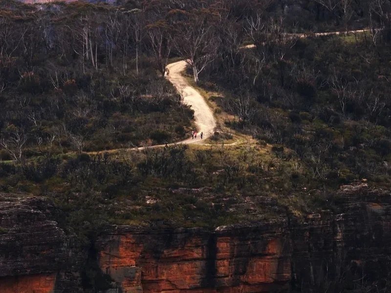
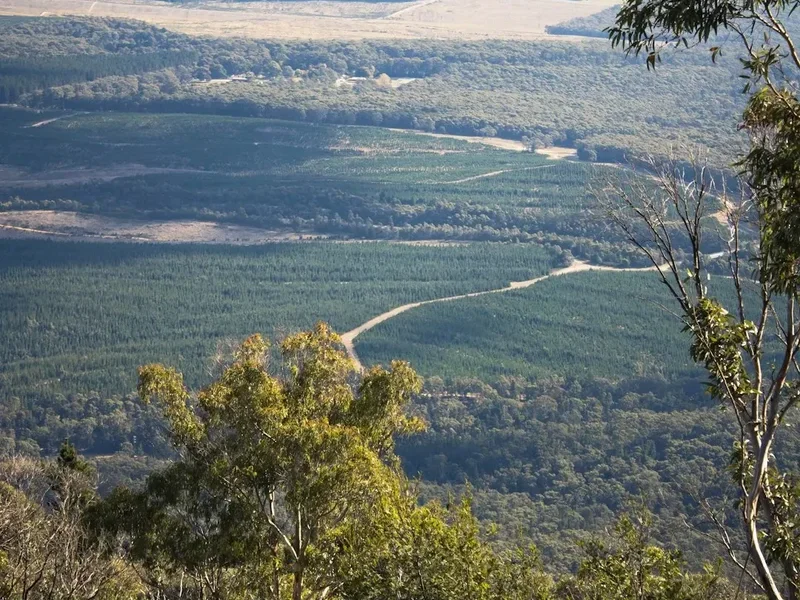
The Cape Raoul Track is a quintessential Tasmanian coastal walk, celebrated for its dramatic geological features and sweeping ocean panoramas. The trail winds through coastal heathland and eucalyptus forests before emerging onto the exposed cliff tops, offering unparalleled views of the Tasman Sea, the iconic dolerite sea stacks, and the vast expanse of the Southern Ocean. The moderate difficulty level, combined with the relatively short duration, makes it an achievable yet rewarding experience for a wide range of walkers.
The walk begins with a gentle ascent through native bushland, providing a sense of seclusion and immersion in the local flora and fauna. As the track progresses, the vegetation thins, and the first glimpses of the dramatic coastline begin to appear. The trail then leads to the edge of the peninsula, where sheer dolerite cliffs drop hundreds of metres to the churning sea below. These cliffs, formed by ancient volcanic activity, are a defining feature of the landscape, sculpted by millennia of wind and wave erosion.
Key highlights include the impressive dolerite columns, the vastness of the ocean, and the potential to spot marine life such as seals, dolphins, and even whales during their migration seasons. The exposed nature of the track means that weather can change rapidly, so walkers should be prepared for all conditions. The return journey offers a different perspective on the landscape, allowing for reflection on the immense scale and power of the natural environment.
History and Cultural Context
The Tasman Peninsula, including the area around Cape Raoul, has a rich and complex history. For millennia, the land was inhabited by the Aboriginal people of Tasmania, who utilised the coastal resources and traversed the landscape for sustenance and cultural practices. Evidence of their presence can be found in the archaeological record, though much of their tangible heritage has been lost due to colonisation.
European settlement in the region began in the early 19th century, with the area later becoming known for its penal colonies, most notably at Port Arthur. The rugged terrain and isolation made it an ideal location for such institutions. Over time, the peninsula also saw development for agriculture and timber harvesting, though the challenging coastal environment has largely preserved its wild character.
The development of walking tracks like the Cape Raoul Track is a more recent phenomenon, driven by a desire to showcase and protect Tasmania's natural beauty. The track itself has been established and maintained by Parks and Wildlife Service Tasmania, ensuring that visitors can safely access and appreciate this remarkable coastal environment. The geological formations, such as the distinctive dolerite columns, are a testament to the region's volcanic past, dating back millions of years. The ongoing erosion by the powerful Southern Ocean continues to shape these dramatic cliffs, creating a dynamic and ever-changing landscape.
Seasonal Highlights and Weather Reality
The Cape Raoul Track is best enjoyed during the warmer months, typically from October to April, which encompass spring, summer, and early autumn in Tasmania. During this period, the weather is generally more stable, with longer daylight hours and a higher probability of clear skies, allowing for the most spectacular views.
Spring (October–November): The landscape comes alive with wildflowers, and the native flora begins to bloom. The weather can be variable, with a mix of sunny days and cooler, wetter periods. Sandflies can start to become active, especially in sheltered, damp areas.
Summer (December–February): This is the warmest and driest period, offering the best conditions for walking. Long daylight hours are ideal for a leisurely pace. However, summer can also bring strong winds, and the exposed nature of the track means that even on warm days, the wind chill can be significant. Sandflies are at their most prevalent during summer.
Autumn (March–April): The colours of the eucalyptus forests can be beautiful, and the weather often remains pleasant with crisp, clear days. The number of sandflies typically decreases. However, as autumn progresses, the likelihood of rain and cooler temperatures increases, and daylight hours shorten.
Winter (May–September): While the track is technically open year-round, winter is generally not recommended for casual day walkers. The weather can be harsh, with frequent rain, strong winds, and cold temperatures. Visibility can be severely reduced by fog and cloud, diminishing the scenic value and increasing the risk of getting lost. Snow is rare at sea level but can occur at higher elevations.
Weather Reality: It is crucial to understand that coastal Tasmania experiences unpredictable weather. Even during the best seasons, conditions can change rapidly. Strong winds are a common feature of the Tasman Peninsula, and rain can occur at any time of year. Always check the weather forecast before you go and be prepared for a range of conditions.
Recommended Itinerary
Cape Raoul Track - Day Walk Itinerary
Early Morning (Approx. 8:00 AM - 9:00 AM): Departure from Hobart
- Begin your journey from Hobart.
- Drive south on the A9 (Tasman Highway) towards Port Arthur.
- The drive takes approximately 2 hours, offering scenic views as you approach the Tasman Peninsula.
- Ensure you have sufficient fuel and supplies before leaving Hobart.
Morning (Approx. 10:00 AM - 10:30 AM): Arrival at Trailhead and Preparation
- Arrive at the Cape Raoul Track trailhead.
- Locate the parking area and prepare for your walk.
- Check trail signage and any recent park alerts.
- Apply sunscreen, insect repellent, and ensure you have water and snacks readily accessible.
- Begin the walk from the trailhead.
Late Morning to Midday (Approx. 10:30 AM - 1:00 PM): Ascent through Forest and Heathland
- The initial section of the track involves a steady climb through coastal eucalyptus forest and heathland.
- Enjoy the sights and sounds of the native bush, with opportunities to spot local birdlife.
- The path is well-maintained but can be uneven in places.
- Distance covered: Approximately 3.5 km to 4.5 km.
- Elevation gain: Gradual ascent, contributing to the overall 400m gain.
Midday to Early Afternoon (Approx. 1:00 PM - 2:30 PM): Reaching the Cliffs and Coastal Vistas
- The vegetation begins to open up, revealing the first expansive views of the coastline.
- The track emerges onto the exposed cliff tops, offering dramatic vistas of the Southern Ocean.
- Key viewpoints include areas overlooking the dolerite sea stacks and the sheer cliff faces.
- This is an ideal time for a break, to enjoy a packed lunch, and to take photographs.
- Distance covered: Approximately 2.5 km to 3 km from the forest edge.
- Elevation: Reaching the highest points of the track.
Afternoon (Approx. 2:30 PM - 4:30 PM): Exploration and Return Journey
- Spend time exploring the cliff-top areas, taking in the panoramic views.
- Be mindful of safety and stay well back from cliff edges.
- Begin the descent back towards the trailhead.
- The return journey offers a different perspective on the landscape.
- Distance covered: Approximately 7.0 km back to the trailhead.
Late Afternoon (Approx. 4:30 PM - 5:00 PM): Completion of Walk and Departure
- Arrive back at the trailhead and parking area.
- Ensure you have collected all your belongings and left the area clean.
- Begin your drive back to Hobart or your accommodation.
Important Notes:
- This is a day walk; no overnight accommodation is required or available on the track.
- The track is exposed in many sections; be prepared for wind and sun.
- Carry sufficient water (at least 1.5-2 litres per person) and food.
- Wear sturdy, comfortable walking shoes or boots.
- Check weather conditions before you depart and be prepared for rapid changes.
Planning and Bookings
Book Your Trip
Everything you need to plan your journey
Accommodation
Find places to stay near Hobart
Flights
Search flights to Hobart
Essential Preparation
The Cape Raoul Track is a day walk, meaning no overnight bookings are required. However, thorough preparation is still essential for a safe and enjoyable experience. The closest major city and logistical hub is Hobart. From Hobart, you will need to drive approximately two hours to reach the trailhead on the Tasman Peninsula. It is advisable to fill up your fuel tank in Hobart or a larger town en route, as services are limited closer to the peninsula. Ensure you have a reliable map or GPS device, as mobile phone reception can be intermittent in some areas. Familiarise yourself with the route and any potential hazards before you depart. Consider the time of year you plan to visit, as this will influence weather conditions and the prevalence of sandflies.
Trail Accommodation
This is a day hike requiring no overnight accommodation.
Required Gear
- Sturdy walking shoes or boots: With good grip and ankle support, as the terrain can be uneven and rocky in places.
- Waterproof and windproof jacket: Essential for protection against unpredictable coastal weather.
- Warm layers: Including a fleece or jumper, as temperatures can drop significantly, especially with wind chill.
- Sun protection: A wide-brimmed hat, sunglasses, and high SPF sunscreen are crucial due to the exposed nature of the track.
- Backpack: A comfortable day pack (20-30 litres) to carry essentials.
- Navigation: A map and compass, or a reliable GPS device with the track downloaded. Mobile phone reception is not guaranteed.
- First-aid kit: Including blister treatment, pain relievers, antiseptic wipes, and any personal medications.
- Head torch: With spare batteries, in case of unexpected delays or if starting very early/finishing late.
What to Bring
- Water: At least 1.5 to 2 litres per person. There are no water sources available on the track.
- Food: Plenty of high-energy snacks and a packed lunch.
- Sandfly repellent: A strong repellent containing DEET or picaridin is highly recommended, especially during warmer months.
- Camera: To capture the stunning scenery.
- Binoculars: For potential wildlife spotting (seals, birds, whales during migration season).
- Trekking poles: Optional, but can be helpful for stability on ascents and descents.
- Small rubbish bag: To pack out all your litter.
Permits
Generally, no specific permits are required to walk the Cape Raoul Track. It is part of the Tasman National Park, and standard entry fees may apply if you are entering the park via a paid entry point, though the trailhead itself is usually accessible without an individual fee for day use. However, it is always advisable to check the official Parks and Wildlife Service Tasmania website for any current alerts, closures, or changes to access conditions before your visit. This is particularly important if there have been recent weather events or if any maintenance work is scheduled for the track.
Key points regarding permits:
- No booking system is in place for this day walk.
- No specific permit is usually required for day access.
- Always check for park alerts and closures on the Parks and Wildlife Service Tasmania website.
- Be aware of any general national park entry fees that may apply to the Tasman National Park area.
Other Activities in the Area
The Tasman Peninsula offers a wealth of attractions and activities beyond the Cape Raoul Track, making it an ideal destination for a multi-day exploration:
- Port Arthur Historic Site: A UNESCO World Heritage site and one of Australia's most significant convict settlements. Explore the ruins, learn about the harsh history, and take a harbour cruise.
- Tasman Arch and Devil's Kitchen: Natural geological formations showcasing the power of erosion. These are easily accessible viewpoints and are often visited in conjunction with the Cape Raoul Track.
- Remarkable Cave: A stunning sea cave accessible via a short walk and a staircase.
- Worm Cave: Another unique geological feature on the peninsula.
- Eaglehawk Neck: Known for its historical significance as a convict-era "dog line" and its beautiful beaches.
- Dolphin Sands: A long, sandy beach perfect for a stroll or a swim (conditions permitting).
- Local Wineries and Breweries: The region boasts several excellent wineries and craft breweries offering tastings and local produce.
- Coastal Drives: Simply driving around the peninsula offers spectacular views and access to numerous smaller bays and lookouts.
- Whale Watching: During the migration season (typically June to October), the waters around the Tasman Peninsula are excellent for spotting whales.
Safety and Conditions
Pre-Departure Checks:
- Weather Forecast: Always check the latest MetService forecast for the Tasman Peninsula and coastal areas before you leave. Pay close attention to wind speed and direction, and the chance of rain or fog.
- Park Alerts: Visit the Parks and Wildlife Service Tasmania website for any track closures, warnings, or essential information regarding the Tasman National Park.
- Trail Conditions: While generally well-maintained, the track can become slippery after rain. Be aware of loose rocks and uneven surfaces.
On the Track:
- Stay on the Marked Path: The cliffs are extremely dangerous. Never stray from the designated track, especially near the edges.
- Wind Exposure: The track is very exposed in sections. Strong winds can make walking difficult and increase the risk of losing balance near cliff edges. Be prepared to turn back if conditions become too severe.
- Sandflies: These biting insects can be a significant nuisance, particularly during warmer months and in sheltered, damp areas. Use effective repellent and cover up where possible.
- Water and Food: Carry more water than you think you will need, as there are no water sources on the track. Pack high-energy snacks and a substantial lunch.
- Communication: Mobile phone reception can be unreliable. Consider carrying a personal locator beacon (PLB) if you are hiking alone or venturing into more remote areas. Inform someone of your plans, including your expected return time.
- First Aid: Be prepared to administer basic first aid for blisters, cuts, or sprains.
- Respect Wildlife: Observe native animals from a distance and do not feed them.
Emergency Contact: In case of emergency, dial 000 (Australia's emergency number). If you have a PLB, activate it according to its instructions.
Side Trips and Points of Interest
While the Cape Raoul Track itself is the primary destination, the surrounding area offers several significant points of interest that can be incorporated into your visit:
Tasman Arch: Located a short drive from the Cape Raoul trailhead, Tasman Arch is a magnificent natural sandstone arch carved by the relentless action of the sea. It's a spectacular example of coastal erosion and offers fantastic photographic opportunities. A short, easy walk leads to viewing platforms.
Devil's Kitchen: Also a short drive away, Devil's Kitchen is a deep chasm or blowhole formed by erosion. Waves crash into the chasm, creating dramatic spray and a powerful spectacle. Viewing platforms provide safe vantage points to observe this natural wonder.
Remarkable Cave: Accessible via a boardwalk and a steep staircase, Remarkable Cave is a large, wedge-shaped sea cave. The cave's unique shape and the way light filters through it make it a truly remarkable sight. It is best viewed at low tide.
Dolphin Sands: For those who enjoy a beach walk, Dolphin Sands offers a long stretch of golden sand, perfect for a leisurely stroll before or after your hike. The waters here can be rough, so swimming is often not advised.
The Blowhole: Another impressive coastal feature where waves are forced through a narrow opening in the rock, creating a powerful spout of water. This is a classic example of coastal erosion at work.
These sites are generally easily accessible by car and involve short, well-maintained walks, making them perfect additions to a day trip to Cape Raoul.
Leave No Trace
The Cape Raoul Track traverses a sensitive coastal environment within the Tasman National Park. Adhering to Leave No Trace principles is crucial to preserving its natural beauty and ecological integrity for future visitors.
Your responsibility as a walker:
- Pack It In, Pack It Out: Carry out all rubbish, including food scraps, wrappers, and any other waste you generate. Do not bury or burn rubbish.
- Stay on the Track: Stick to the marked path to avoid damaging fragile vegetation, preventing erosion, and protecting the habitat of native wildlife. The coastal heathland is particularly vulnerable.
- Respect Wildlife: Observe animals from a distance. Do not feed them, as this can disrupt their natural behaviour and diet, and can lead to them becoming habituated to humans.
- Dispose of Waste Properly: Use designated toilet facilities where available. If not, dig a cathole at least 100 metres away from water sources, trails, and campsites, and bury human waste. Pack out all toilet paper.
- Leave What You Find: Do not take rocks, plants, or any other natural objects from the park.
- Minimise Campfire Impacts: Campfires are generally not permitted on this day walk. If camping in designated areas elsewhere in the park, use existing fire rings and ensure fires are completely extinguished.
- Be Considerate of Other Visitors: Keep noise levels down, yield to other walkers, and maintain a respectful attitude towards the natural environment and fellow visitors.
By following these principles, you help ensure that the Cape Raoul Track remains a pristine and enjoyable experience for everyone.