Canyonlands Maze District - The Labyrinth of the Desert
The Maze District of Canyonlands National Park represents the pinnacle of remote desert exploration in the United States. Spanning a vast, fractured landscape of sandstone fins, deep slot canyons, and towering spires, this 72.4 km trek is not merely a walk but a complex navigational puzzle that challenges the most experienced backcountry travellers. Located in one of the most inaccessible corners of the lower 48 states, the Maze is defined by its profound silence, its geological complexity, and a level of isolation that is increasingly rare in the modern world. Unlike the more accessible Island in the Sky or the popular Needles District, the Maze demands total self-sufficiency, advanced route-finding skills, and a deep respect for the harsh realities of the high desert environment. This is a journey into a vertical wilderness where the trail is often marked only by small stone cairns and where a single navigational error can lead to hours of backtracking through a literal labyrinth of stone.
- Distance: 72.4 km (variable based on route choice)
- Duration: 5–7 days
- Season: Spring (March–May) and Autumn (September–October)
- Difficulty: Very Challenging (Technical scrambling and navigation required)
- Highest point: Hans Flat Ranger Station (2,012 m)
- Lowest point: Spanish Bottom / Colorado River (1,188 m)
- Access: High-clearance 4WD vehicle essential; remote trailhead
- Water: Extremely scarce; must be cached or carried in high volumes
Overview
The Maze District is the least accessible district of Canyonlands National Park, separated from the rest of the park by the formidable barriers of the Green and Colorado Rivers. It is a landscape of tiered complexity, where the upper "flats" give way to a middle layer of intricate canyons, which eventually drop into the river corridors. The name "The Maze" is no hyperbole; the drainage patterns in the Orange Cliffs and the Cedar Mesa Sandstone are so convoluted that from many vantage points, it is impossible to discern which canyon leads to the river and which ends in a sheer 100-metre drop. This geological chaos was famously described by Edward Abbey as "the most world-forsaken bottom of the world," yet for those who seek true wilderness, it is a sanctuary of unparalleled beauty.
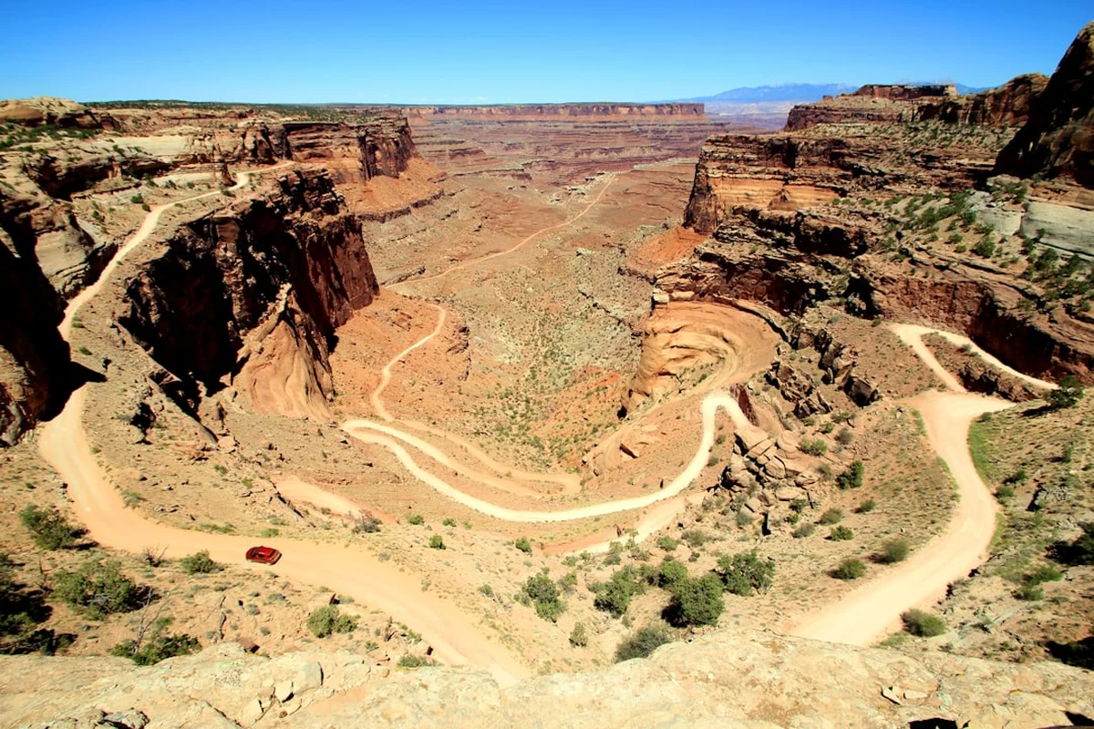
The trek typically begins at the Hans Flat Ranger Station, perched on the edge of the Orange Cliffs. From here, hikers descend through millions of years of geological history, moving from the Wingate Sandstone of the cliffs down into the white-capped fins of the Maze itself. The terrain is characterised by "Moki steps"—ancient hand-and-foot holds carved into the rock—steep talus slopes, and narrow slots that require packs to be hauled by rope. There are no maintained trails in the traditional sense; instead, hikers follow "routes" that require constant attention to topographic maps and GPS coordinates. The physical demand is high, with constant elevation changes as the route weaves in and out of canyon systems, but the psychological demand of navigating such a disorienting landscape is what truly defines the Maze experience.
The rewards for this effort are profound. The Maze contains some of the most significant rock art in North America, including the haunting, life-sized figures of the Harvest Scene. The silence here is absolute, broken only by the occasional cry of a raven or the whistle of wind through the needles of pinyon pines. At night, the sky offers some of the darkest conditions in the continental United States, with the Milky Way appearing as a brilliant, three-dimensional cloud of light. To walk the Maze is to step back into a primordial version of the American West, where the land remains indifferent to human presence and where the scale of time is measured in the slow erosion of sandstone rather than the ticking of a clock.
History and Cultural Context
The human history of the Maze District is as layered as its geology. For thousands of years, this region was home to Indigenous peoples, primarily the Ancestral Puebloans (formerly known as Anasazi) and the Fremont culture. These groups inhabited the canyons between 700 and 1300 CE, leaving behind an incredible legacy of granaries, dwellings, and rock art. The "Great Gallery" in the nearby Horseshoe Canyon (a detached unit of the park) and the "Harvest Scene" within the Maze itself are world-renowned examples of the Barrier Canyon Style of pictographs. These haunting, anthropomorphic figures, often depicted without arms or legs and decorated with intricate patterns, date back as far as 2,000 to 4,000 years, suggesting a deep spiritual connection to this labyrinthine landscape that predates modern agricultural societies.
In more recent history, the Maze became a legendary hideout for outlaws. During the late 19th and early 20th centuries, the "Outlaw Trail" ran through this region, providing a nearly impenetrable refuge for figures like Butch Cassidy and the Wild Bunch. The "Robbers Roost" area, located just west of the Maze, served as a base where outlaws could disappear for months, knowing that law enforcement would never risk the treacherous descent into the canyons. The complexity of the terrain meant that a small group of men who knew the hidden springs and secret passes could evade much larger posses with ease. This era of "social banditry" added a layer of romanticised grit to the region's reputation, cementing its status as a place where one goes to be lost.
European exploration and surveying of the Maze occurred much later than in other parts of the West. It wasn't until the late 1800s and early 1900s that cattlemen began pushing herds into the fringes of the district, and even then, the heart of the Maze remained largely unknown. The area was eventually protected as part of Canyonlands National Park in 1964, thanks in large part to the advocacy of Stewart Udall and the evocative descriptions of the landscape by writers and explorers. Today, the National Park Service manages the Maze with a "minimum tool" philosophy, preserving its rugged character by limiting infrastructure and maintaining the difficult access that has protected its cultural and natural integrity for centuries.
Want more background? Read extended notes on history and cultural context → Learn more
Seasonal Highlights and Weather Reality
Timing is the most critical factor when planning a trek into the Maze. The high desert environment is a land of extremes, where temperatures can swing 30°C in a single day and where the lack of shade and water makes summer travel life-threatening. The "Great Walk" season for the Maze is strictly limited to the shoulder months when the weather is temperate enough for the heavy physical exertion required.
Spring (March to May): This is arguably the best time to visit. Daytime temperatures typically range from 15°C to 25°C, providing ideal conditions for hiking. Wildflowers, including desert primrose, Indian paintbrush, and globe mallow, bloom in the canyon bottoms, adding vibrant splashes of colour to the red rock. However, spring is also the windiest season; "sandblasting" winds can scour the flats, making camping difficult. Water may be slightly more available in ephemeral tinajas (natural rock basins) following winter snowmelt, but this should never be relied upon as a primary source.
Autumn (September to October): Autumn offers stable weather and crisp, clear skies. Temperatures are similar to spring, but the winds are generally calmer. The cottonwood trees in the canyon bottoms turn a brilliant gold, creating a stunning contrast against the blue sky and red sandstone. This is the most popular time for experienced trekkers, meaning permit competition is at its highest. By late October, nights can drop below freezing, requiring high-quality insulating gear.
Summer (June to August): Travel in the Maze during summer is strongly discouraged. Temperatures frequently exceed 40°C in the shade—and there is very little shade to be found. The heat radiating off the sandstone can make the canyon floors feel like an oven. Furthermore, summer is the season of the North American Monsoon; sudden, violent thunderstorms can trigger catastrophic flash floods in the narrow canyons. A storm 50 kilometres away can send a wall of water, mud, and debris down a canyon that was bone-dry minutes earlier.
Winter (November to February): Winter in the Maze is a season of profound solitude but significant challenge. Snow can make the unpaved access roads impassable, even for 4WD vehicles. Temperatures often remain below freezing during the day and can drop to -15°C at night. While the sight of snow on red rock is spectacular, the technical sections of the trail (like the Moki steps) become dangerously slick when iced over.
Recommended Itinerary
7-Day Maze District Loop Itinerary
Day 1: Hans Flat to Maze Overlook
- Distance: 22.5 km (if walking the road) or 4WD drop-off
- Elevation gain: 150 m (mostly descent)
- Time: 6–8 hours
- Start at Hans Flat Ranger Station (2,012 m)
- Descend the Flint Trail switchbacks—a steep, technical section of unpaved road
- Traverse the North Trail Canyon or follow the road to the Maze Overlook
- Arrive at Maze Overlook campsite
- The view from the Overlook provides your first comprehensive look at the "fins" of the Maze
- Set up camp on the rim; this is one of the most spectacular campsites in the American West
Day 2: Maze Overlook to the Harvest Scene
- Distance: 8 km
- Elevation: 300 m descent, then flat canyon walking
- Time: 5–6 hours
- Descend from the rim into the Maze via the "Moki Steps"—a technical scramble requiring pack-lowering
- Navigate the bottom of the South Fork of Horse Canyon
- Locate the Harvest Scene pictograph panel—one of the most significant rock art sites in the world
- Camp in the vicinity of the Harvest Scene (ensure you are the required distance from the art)
- This day involves intense navigation; the canyon floor is a tangle of vegetation and boulders
Day 3: Harvest Scene to Land of Standing Rocks
- Distance: 12 km
- Elevation: 250 m gain
- Time: 7–8 hours
- Exit the canyon system via a steep, unmarked route toward the "Plug"
- Cross the open desert flats toward the Land of Standing Rocks
- Pass the "Chocolate Drops"—four massive sandstone pillars atop a high ridge
- Arrive at the Land of Standing Rocks (Chimney Rock or Lizard Rock area)
- The terrain shifts from deep canyons to wide-open vistas dominated by monolithic spires
Day 4: Land of Standing Rocks to The Doll House
- Distance: 14 km
- Elevation: Minimal net change, but constant small ups and downs
- Time: 6–7 hours
- Follow the rugged 4WD track or parallel cross-country routes south
- Navigate around the "Beehive" formations
- Enter the Doll House area—a collection of whimsical, rounded sandstone pinnacles
- Camp at one of the three designated Doll House sites
- The Doll House offers incredible opportunities for evening photography and short explorations
Day 5: The Doll House and Spanish Bottom
- Distance: 6 km (return)
- Elevation: 350 m descent to river, 350 m ascent back
- Time: 4–5 hours
- Descend the steep trail from the Doll House to Spanish Bottom
- Reach the banks of the Colorado River—the first reliable water source (requires heavy filtration)
- Observe the "Surprise Valley" grabens—geological features where the earth has literally dropped
- Return to the Doll House for a second night
- This is a "recovery" day with less mileage but significant vertical work
Day 6: The Doll House to Chimney Rock
- Distance: 15 km
- Elevation: 200 m gain
- Time: 7–8 hours
- Begin the return journey heading north
- Traverse the high benches above the canyons for expansive views of the Needles District across the river
- Pass through the "Shot Canyon" and "Water Canyon" overlooks
- Camp at Chimney Rock
- The sunset at Chimney Rock illuminates the Orange Cliffs in brilliant shades of crimson
Day 7: Chimney Rock to Hans Flat
- Distance: 18 km (if walking) or 4WD pickup
- Elevation: 300 m gain
- Time: 6–8 hours
- Ascend the Flint Trail switchbacks back to the Hans Flat plateau
- Final push across the flats to the Ranger Station
- Check out with the rangers and ensure your vehicle is operational
- The final ascent is physically demanding, especially with a week's worth of fatigue
Important Notes:
- All overnight stays require a backcountry permit from the NPS
- Water is the primary constraint; you must carry at least 4–6 litres per person per day if not caching
- Navigation is via topographic map and compass; GPS is a secondary tool
- Pack-lowering ropes (15–20 metres) are essential for the Moki steps
- High-clearance 4WD with a low-range transfer case is mandatory for trailhead access
- The "trail" is often just a series of cairns; if you haven't seen a cairn in 100 metres, turn back
Planning and Bookings
Book Your Trip
Everything you need to plan your journey
Accommodation
Find places to stay near Moab, Utah
Flights
Search flights to Moab, Utah
Essential Preparation
Planning a trip to the Maze is a logistical undertaking that begins months in advance. The most critical component is vehicle coordination. The road to Hans Flat is 74 kilometres of unpaved dirt, and the road from Hans Flat down to the Maze Overlook or the Doll House is among the most difficult 4WD tracks in the United States. If you do not have a high-clearance 4WD vehicle with a low-range gear (and the knowledge of how to use it), you must arrange for a shuttle or plan to walk significantly longer distances. Moab, Utah, is the nearest major town (approximately 2.5 to 3 hours away) and serves as the base for supplies, gear rentals, and last-minute information.
Physical fitness is paramount. You will be carrying a heavy pack (due to water weight) over uneven, rocky terrain that requires frequent scrambling. You should be comfortable with heights and basic rock climbing movements. Furthermore, you must be proficient in desert navigation. The Maze is famous for "false" canyons that look like the main route but end in impassable pour-offs.
Trail Accommodation
There are no huts, lodges, or developed facilities within the Maze District. Accommodation consists entirely of designated backcountry campsites. These sites are "primitive," meaning they are simply a specific area where camping is permitted to concentrate human impact.
Campsite Details:
- Designated sites: Maze Overlook, Land of Standing Rocks, Chimney Rock, The Doll House
- Facilities: None. No water, no toilets, no tables, no shade structures
- Capacity: Usually limited to one group (up to 7 people) per site
- Booking: Mandatory through the NPS backcountry reservation system
- Cost: Approximately US$36 for the permit, plus a per-person nightly fee
What is NOT provided:
- Water: You must carry all water or cache it in advance
- Waste Disposal: You must carry out all human waste using "wag bags" (human waste disposal bags)
- Protection: No emergency shelters exist; your tent must be capable of withstanding high desert winds
Required Gear
- Topographic Maps: 7.5-minute USGS quads (The Maze, Spanish Bottom, Hans Flat) are essential
- Compass and GPS: Do not rely solely on electronics; the deep canyons can block satellite signals
- Pack-lowering Rope: 15–20 metres of 6mm accessory cord for hauling packs up/down technical sections
- 4WD Vehicle: High clearance, 4-wheel drive, and a full-sized spare tyre (two spares recommended)
- Sturdy Boots: High-quality leather or synthetic boots with excellent grip for slickrock
- Desert Clothing: Lightweight, long-sleeved sun shirts, wide-brimmed hat, and a buff
- Emergency Signalling: A Personal Locator Beacon (PLB) or satellite messenger (e.g., Garmin inReach)
- Repair Kit: For both your gear and your vehicle (tyre plugs, basic tools)
What to Bring
- Water: 4–6 litres per person, per day. This is non-negotiable. If you are out for 5 days, you need 20–30 litres
- Water Treatment: High-quality filter (e.g., Katadyn Pocket) and chemical backup (Aquamira) for river water
- Food: High-calorie, lightweight meals. Avoid foods that require excessive water for preparation
- Human Waste Bags: "Wag bags" are mandatory in the Maze; you must pack out all solid waste
- Sun Protection: SPF 50+ sunscreen, lip balm with SPF, and high-quality sunglasses
- First Aid: Focus on blister care, dehydration salts (electrolytes), and tweezers for cactus spines
- Electrolytes: Essential for maintaining salt balance in high heat
- Warm Layers: A down jacket and thermal base layers for cold desert nights
Permits
Permits for the Maze District are highly sought after and strictly limited to prevent overcrowding and environmental degradation. The National Park Service (NPS) manages these through an online reservation system. Because the Maze is so remote, the number of people allowed in each "zone" or at each designated campsite is very low, often just one or two groups per night.
Booking Strategy:
- Reservations open four months in advance on the first of the month (e.g., for a September trip, bookings open May 1st)
- Create an account on Recreation.gov well before the booking window opens
- Be online at exactly 8:00 AM Mountain Time on the day reservations open
- Have a primary route and at least two backup itineraries ready, as specific campsites (like the Doll House) sell out in seconds
- If you miss the online window, a very small number of "walk-in" permits may be available at the Hans Flat Ranger Station, but this is a massive gamble given the driving distance
Permit Costs:
- Backcountry Permit Fee: US$36 per permit (non-refundable)
- Nightly Fee: US$5 per person, per night
- Vehicle Entry Fee: US$30 per vehicle (standard National Park entry fee, or use an America the Beautiful pass)
Important Regulations:
- Group size is limited to 7 people and 3 vehicles
- Permits must be printed and carried by the group leader at all times
- You must camp in the specific site or zone designated on your permit
- Wood fires are strictly prohibited; use only gas stoves for cooking
Other Activities in the Area
The region surrounding the Maze District offers several other world-class adventures for those with extra time and a capable vehicle:
- Horseshoe Canyon (The Great Gallery): Located north of the Maze, this detached unit of Canyonlands contains the most famous rock art in North America. A 11.2 km round-trip hike leads to the Great Gallery, featuring life-sized, ghostly figures painted thousands of years ago.
- Orange Cliffs Unit: Managed by Glen Canyon National Recreation Area but adjacent to the Maze, the Orange Cliffs offer spectacular rim-top camping and hiking with views that rival the Grand Canyon.
- Packrafting the Green or Colorado Rivers: Many adventurers combine a Maze trek with a river crossing. You can hike to Spanish Bottom, inflate a packraft, and cross the Colorado River to access the Needles District.
- Robbers Roost: Explore the historic hideouts of Butch Cassidy's Wild Bunch. This area is famous for its technical slot canyons (canyoneering) like Bluejohn Canyon.
- Moab Mountain Biking: On your way in or out, the town of Moab offers world-famous trails like the Whole Enchilada or Slickrock.
Safety and Conditions
Pre-Departure Checks:
- Check the weather forecast specifically for "The Maze" and "Hans Flat" on the National Weather Service website
- Consult with the rangers at Hans Flat regarding current road conditions; rain can turn the clay roads into impassable "grease"
- Ensure your vehicle is in peak mechanical condition; a breakdown in the Maze can result in a recovery fee exceeding US$1,500
- Leave a detailed trip itinerary with a trusted person who is not on the trip
Flash Flood Hazards: Flash floods are a lethal threat in the desert. They can occur even if it is not raining where you are. Never enter a narrow canyon if there are dark clouds in the drainage upstream. If you hear a low rumble or see water rising, immediately climb to the highest ground possible. Do not attempt to outrun a flood in the canyon floor.
Heat and Dehydration: Hyponatremia (low blood salt) and heatstroke are common in the Maze. Drink plenty of water, but also consume salt and electrolytes. If you stop sweating, become confused, or develop a headache, you are in the early stages of heat illness. Stop, find shade, and cool down immediately.
Navigation and Self-Rescue: The Maze is a "self-rescue" area. Help is many hours, if not days, away. If you get lost, stay put. Do not continue wandering into deeper canyons. Use your signalling device only in a true life-or-death emergency. Remember that GPS units can fail or lose signal in deep canyons; always know your position on a paper map.
Wildlife: While rare, rattlesnakes and scorpions inhabit the area. Always look before placing your hands or feet in rocky crevices. Black bears are occasionally sighted near the river, so proper food storage is required.
Side Trips and Points of Interest
The Harvest Scene: This is the spiritual heart of the Maze. Located in a sheltered alcove in Horse Canyon, this pictograph panel features intricate figures that appear to be holding stalks of grass or grain. The detail is staggering, with some figures showing internal organs or complex textile patterns. It is one of the finest examples of prehistoric art in existence.
The Chocolate Drops: These four massive blocks of chocolate-coloured shale sit atop a narrow ridge of white sandstone. They are visible from miles away and serve as a primary navigational landmark. A steep scramble leads to the base of the drops, offering a 360-degree view of the entire Maze District.
The Doll House: A geological wonderland of red and white banded sandstone spires. The area is a natural playground of hidden passages, small caves, and "rooms" formed by the erosion of the rock. It is located near Spanish Bottom and provides the easiest access to the Colorado River.
The Plug and Lizard Rock: These are prominent volcanic-looking plugs (though they are actually sandstone) that rise abruptly from the desert floor. They are excellent landmarks for cross-country navigation between the canyons and the Land of Standing Rocks.
Spanish Bottom: A large, flat alluvial fan on the banks of the Colorado River. It is a popular spot for river rafters to stop and for hikers to catch their breath before the steep climb back up to the Doll House. The contrast between the green river water and the red canyon walls is breathtaking.
Leave No Trace
The Maze is an extremely fragile environment. Because of the low rainfall, human impacts can last for decades or even centuries. It is your responsibility to ensure that the next visitor finds the wilderness as pristine as you did.
Your responsibility as a walker:
- Don't Bust the Crust: The desert floor is covered in biological soil crust (cryptobiotic soil)—a living community of cyanobacteria, lichens, and mosses. This crust prevents erosion and fixes nitrogen. A single footprint can kill crust that took 50 years to grow. Always walk on established trails, in dry washes (arroyos), or on bare rock.
- Pack Out All Waste: This includes all food scraps, orange peels, and human waste. Use the mandatory wag bags for solid waste and pack them out in a dedicated "trash tube" or heavy-duty dry bag.
- Respect Rock Art: Never touch pictographs or petroglyphs. The oils from your skin accelerate the degradation of the pigments. Never add your own "art" or graffiti to the walls.
- Water Etiquette: If you find a tinaja (rock pool), do not wash in it or contaminate it. This may be the only water source for local wildlife. Collect water and move at least 60 metres away to filter or wash.
- Leave What You Find: It is illegal to remove any archaeological artefacts, including pottery sherds or arrowheads. Leave them exactly where you found them for others to discover.