Camino del Norte - The Rugged Coastal Pilgrimage
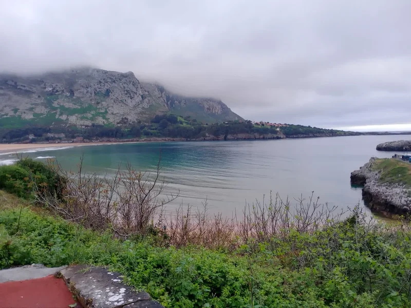
The Camino del Norte, or the Northern Way, is one of the most spectacular and physically demanding pilgrimage routes leading to Santiago de Compostela. Stretching approximately 820 kilometres along the northern coastline of Spain, this ancient path traverses four distinct regions: the Basque Country, Cantabria, Asturias, and Galicia. Unlike the more famous Camino Francés, the Northern Way hugs the wild Atlantic coast, offering pilgrims a dramatic landscape of jagged cliffs, hidden emerald coves, and historic fishing villages. It is a journey of profound contrasts, where the salty air of the Bay of Biscay meets the lush, mountainous hinterlands of the Cordillera Cantábrica. For those seeking a quieter, more introspective experience away from the crowds of the inland routes, the Camino del Norte provides a challenging but deeply rewarding alternative that tests the legs and nourishes the soul.
- Distance: 820.0 km one-way
- Duration: 30–35 days
- Season: May to October (shoulder seasons of May–June and September–October preferred)
- Accommodation: Albergues (pilgrim hostels), pensions, and small hotels
- Highest point: Approximately 700 m (near the border of Asturias and Galicia)
- Total Elevation Gain: 17,000 m
- Difficulty: Moderate to Strenuous (due to frequent elevation changes and asphalt walking)
- Direction: East to West (Irún to Santiago de Compostela)
Overview
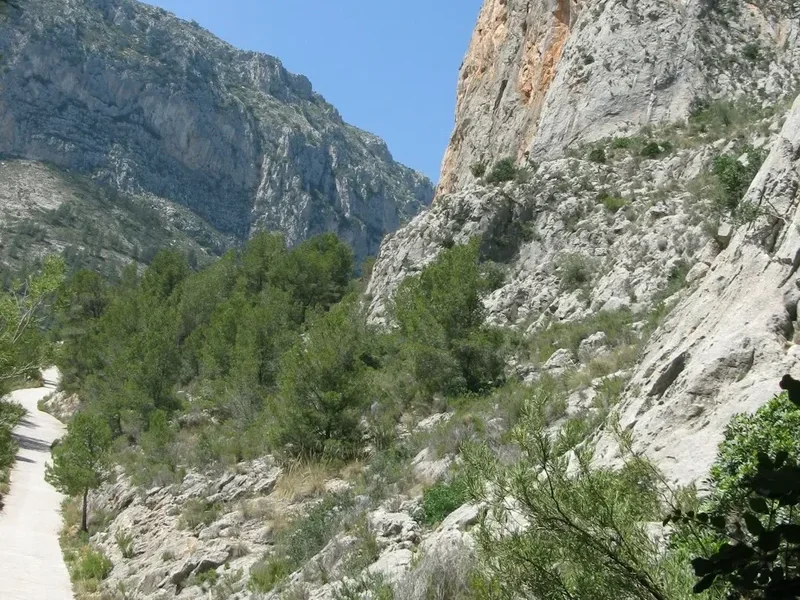
The Camino del Norte is often described as the "connoisseur's Camino." While the Camino Francés offers rolling plains and vast mesetas, the Norte is defined by its verticality and its relationship with the sea. The route begins in Irún, on the French border, and immediately plunges the pilgrim into the steep, verdant hills of the Basque Country. Here, the trail is a constant rhythm of "rompepiernas" (leg-breakers)—short, sharp climbs followed by steep descents into coastal towns like San Sebastián and Zarautz. The scenery is breathtaking, featuring some of the most dramatic coastal vistas in Europe, but the physical toll is significantly higher than on the more traditional inland routes.
As the trail moves west into Cantabria and Asturias, the landscape softens slightly but remains rugged. Pilgrims walk through medieval towns like Santillana del Mar and Comillas, passing pre-Romanesque churches and architectural marvels. The weather in Northern Spain, often referred to as "España Verde" (Green Spain), is notoriously unpredictable. Even in the height of summer, mist and rain are common, contributing to the lush, almost Irish-looking landscape. This moisture is what keeps the forests deep green and the cider orchards of Asturias flourishing, but it also means that pilgrims must be prepared for mud and slippery limestone paths.
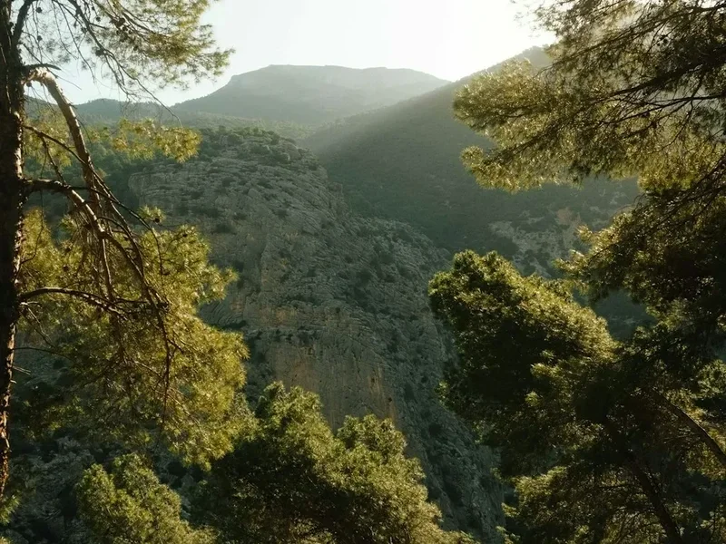
The final third of the journey turns inland at Ribadeo, leaving the coast behind to enter the mystical, mist-shrouded hills of Galicia. The terrain here becomes more forested, dominated by eucalyptus and oak, as the path climbs toward the Monastery of Sobrado dos Monxes before finally merging with the Camino Francés in Arzúa for the final two days into Santiago. The Camino del Norte is not just a physical trek; it is a cultural immersion into the unique languages, cuisines, and traditions of Northern Spain, from the pintxos of San Sebastián to the fabada of Asturias and the pulpo of Galicia.
History and Cultural Context
The origins of the Camino del Norte date back to the 9th and 10th centuries, making it one of the oldest established pilgrimage routes to Santiago. During the period of the Reconquista, when much of the Iberian Peninsula was under Moorish control, the inland routes were often considered too dangerous for Christian pilgrims. The Northern Way, protected by the Cantabrian Mountains to the south and the sea to the north, provided a safer passage for those travelling from France, England, and Northern Europe. It was the preferred route of European royalty and the elite for centuries, until the shifting borders of the Reconquista allowed the Camino Francés to become the primary artery of pilgrimage.
The route fell into relative obscurity for several hundred years, used primarily by locals and a handful of intrepid travellers. However, the late 20th-century revival of the Camino de Santiago saw a renewed interest in the Northern Way. In 2015, UNESCO recognised its historical and cultural significance by adding the Camino del Norte (along with the Camino Primitivo) to the World Heritage list as an extension of the "Routes of Northern Spain." This designation has led to improved waymarking and an increase in the number of albergues, though it remains significantly less crowded than the Francés.
Culturally, the Norte is a fascinating tapestry. In the Basque Country (Euskadi), you will hear Euskara, a language unrelated to any other in the world. In Asturias, the pre-Romanesque architecture serves as a reminder of the Kingdom of Asturias, the cradle of the Reconquista. The trail passes through cities that have undergone massive transformations, such as Bilbao, which evolved from an industrial port to a global cultural centre. Walking the Norte is as much a journey through Spanish history and regional identity as it is a religious or spiritual pilgrimage.
Want more background? Read extended notes on history and cultural context → Learn more
Seasonal Highlights and Weather Reality
The Camino del Norte is best walked between May and October. Unlike the central plains of Spain, which can become dangerously hot in July and August, the northern coast enjoys a temperate maritime climate. However, this comes with a trade-off: rain is a possibility at any time of year.
Spring (May to June): This is arguably the best time to walk. The wildflowers are in full bloom, the days are lengthening, and the albergues are not yet at full capacity. The temperatures are mild, usually ranging between 12°C and 20°C, though the "Galician mist" can still bring damp mornings.
Summer (July to August): This is the peak season for Spanish tourists visiting the northern beaches. While the coastal breeze keeps the heat manageable (rarely exceeding 28°C), accommodation can be very difficult to find. Many albergues fill up by early afternoon, and prices for private rooms skyrocket. This is the driest time of year, but also the most crowded.
Autumn (September to October): Another excellent window. The sea remains warm enough for a post-walk swim in September, and the autumn colours in the Galician forests are spectacular. By mid-October, many seasonal albergues begin to close, and the frequency of Atlantic storms increases, bringing heavier rain and wind.
Winter (November to April): Walking the Norte in winter is only for the most experienced and self-sufficient pilgrims. Many albergues are closed, and the mountain passes can be covered in snow or deep mud. The coastal winds are fierce, and the high humidity makes the cold feel much more biting. Daylight hours are short, and the social aspect of the Camino is largely absent.
Recommended Itinerary
35-Day Camino del Norte Itinerary
Day 1: Irún to San Sebastián
- Distance: 24.8 km
- Elevation gain: 950 m
- Time: 7–8 hours
- Cross the bridge from France into Spain
- Climb to the Ermita de Guadalupe for views over the Bidasoa estuary
- Traverse the rugged ridge of Mount Jaizkibel
- Take the small ferry across the harbour at Pasaia Donibane
- Finish at the famous La Concha beach in San Sebastián
Day 2: San Sebastián to Zarautz
- Distance: 22.2 km
- Elevation gain: 500 m
- Time: 5–6 hours
- Climb out of the city via Mount Igueldo
- Walk through rolling pastures and vineyards producing Txakoli wine
- Pass through the charming village of Orio
- Descend into Zarautz, a popular surfing destination
Day 3: Zarautz to Deba
- Distance: 21.8 km
- Elevation gain: 650 m
- Time: 5–6 hours
- Follow the coastal road to Getaria, home of Juan Sebastián Elcano
- Climb through rural Basque farmland with views of the Flysch rock formations
- Steep descent into the industrial but historic town of Deba
Day 4: Deba to Markina-Xemein
- Distance: 24.3 km
- Elevation gain: 800 m
- Time: 6–7 hours
- The trail turns inland, entering deep, quiet forests
- Significant climbing through the Arno Mountains
- Visit the Ermita de San Arno
- Arrive in Markina, famous for its Basque Pelota court
Day 5: Markina-Xemein to Gernika
- Distance: 25.0 km
- Elevation gain: 550 m
- Time: 6–7 hours
- Pass the Monastery of Zenarruza, a historic pilgrim stop
- Walk through the heart of the Basque countryside
- Arrive in Gernika, the symbolic heart of Basque culture and subject of Picasso's famous painting
Day 6: Gernika to Lezama
- Distance: 21.0 km
- Elevation gain: 450 m
- Time: 5–6 hours
- Climb out of the Gernika valley through pine and eucalyptus forests
- Follow the ridge with views of the surrounding mountains
- Descend into the valley of Lezama, near the Bilbao airport
Day 7: Lezama to Bilbao
- Distance: 11.5 km
- Elevation gain: 250 m
- Time: 3 hours
- A short day to allow for exploration of Bilbao
- Climb Mount Avril for a panoramic view of the city
- Descend the Mallona stairs into the Casco Viejo (Old Town)
- Visit the Guggenheim Museum and enjoy the city's world-class gastronomy
Day 8: Bilbao to Portugalete
- Distance: 19.5 km
- Elevation gain: 150 m
- Time: 4–5 hours
- Follow the Nervión River through the industrial heart of the city
- Pass the Euskalduna Palace and the maritime museum
- Cross the UNESCO-listed Vizcaya Bridge (a hanging transporter bridge) into Portugalete
Day 9: Portugalete to Castro Urdiales
- Distance: 27.5 km
- Elevation gain: 400 m
- Time: 7–8 hours
- Leave the Basque Country and enter the region of Cantabria
- Follow a scenic coastal path (Vía Verde) along old railway lines
- Arrive in Castro Urdiales, dominated by its Gothic church and seaside castle
Day 10: Castro Urdiales to Laredo
- Distance: 26.5 km
- Elevation gain: 500 m
- Time: 7–8 hours
- Choose between the coastal route (scenic but rugged) or the inland route (easier)
- Pass through the Liendo Valley
- Descend into Laredo, known for its massive sandy beach, Salvé
Day 11: Laredo to Güemes
- Distance: 29.0 km
- Elevation gain: 350 m
- Time: 7–8 hours
- Take the boat across the bay from Laredo to Santoña
- Walk along the coast through marshes and over cliffs
- Arrive in Güemes, home to the famous "Albergue del Abuelo Peuto," a legendary pilgrim hostel
Day 12: Güemes to Santander
- Distance: 15.5 km
- Elevation gain: 100 m
- Time: 4 hours
- Walk along the spectacular cliffs of Galizano and Somo
- Take the "Pedreñera" ferry across the bay into the heart of Santander
- Explore the capital of Cantabria and its elegant beaches
Day 13: Santander to Santillana del Mar
- Distance: 37.0 km (often split into two days)
- Elevation gain: 450 m
- Time: 9–10 hours
- A long day through the Cantabrian suburbs and rural villages
- Pass through Santa Cruz de Bezana and Requejada
- Arrive in Santillana del Mar, a perfectly preserved medieval village often called "The Town of Three Lies"
Day 14: Santillana del Mar to Comillas
- Distance: 22.0 km
- Elevation gain: 350 m
- Time: 5–6 hours
- Walk through rolling green hills with the Picos de Europa visible in the distance
- Pass through the village of Cobreces
- Arrive in Comillas, home to Gaudí's "El Capricho" and the Pontifical University
Day 15: Comillas to Colombres
- Distance: 29.0 km
- Elevation gain: 450 m
- Time: 7–8 hours
- Cross the Oyambre Natural Park with its stunning estuary and beach
- Pass through San Vicente de la Barquera, a beautiful fishing port
- Cross the border from Cantabria into Asturias
- Arrive in Colombres, famous for its "Indiano" architecture
Day 16: Colombres to Llanes
- Distance: 23.0 km
- Elevation gain: 300 m
- Time: 5–6 hours
- Follow the coastal path past the "Bufones de Pria" (sea geysers, active in rough seas)
- Walk through small Asturian hamlets
- Arrive in Llanes, a vibrant town with a historic centre and the "Cubos de la Memoria" art installation
Day 17: Llanes to Ribadesella
- Distance: 31.5 km
- Elevation gain: 400 m
- Time: 8–9 hours
- A long but beautiful day following the coast
- Pass the unique inland beach of Gulpiyuri
- Arrive in Ribadesella, situated at the mouth of the Sella River
Day 18: Ribadesella to Colunga
- Distance: 20.0 km
- Elevation gain: 350 m
- Time: 5 hours
- Climb out of Ribadesella with views back over the coast
- Walk through the "Dinosaur Coast," where footprints can be found on the beaches
- Arrive in the quiet town of Colunga
Day 19: Colunga to Villaviciosa
- Distance: 17.5 km
- Elevation gain: 250 m
- Time: 4–5 hours
- A shorter day through cider country
- Pass the pre-Romanesque church of San Salvador de Priesca
- Arrive in Villaviciosa, the "Cider Capital" of Asturias
Day 20: Villaviciosa to Gijón
- Distance: 29.5 km
- Elevation gain: 650 m
- Time: 8 hours
- A challenging climb over the Alto de la Cruz
- Choose between the route to Gijón or the branch to Oviedo (Camino Primitivo)
- Descend into Gijón, a large coastal city with a Roman history
Day 21: Gijón to Avilés
- Distance: 25.0 km
- Elevation gain: 300 m
- Time: 6–7 hours
- Walk through the industrial outskirts of Gijón
- The trail becomes more rural as it approaches Avilés
- Explore the medieval centre of Avilés and the modern Niemeyer Centre
Day 22: Avilés to Muros de Nalón
- Distance: 22.5 km
- Elevation gain: 400 m
- Time: 5–6 hours
- Pass through the town of Cudillero (requires a short detour, highly recommended)
- Walk through eucalyptus forests and over the Nalón River
- Arrive in Muros de Nalón
Day 23: Muros de Nalón to Soto de Luiña
- Distance: 16.0 km
- Elevation gain: 300 m
- Time: 4 hours
- A shorter, scenic day along the coast
- Pass through the beautiful village of El Pito
- Arrive in Soto de Luiña, a historic stop for pilgrims
Day 24: Soto de Luiña to Cadavedo
- Distance: 18.5 km
- Elevation gain: 450 m
- Time: 5 hours
- Follow the "Senda de la Costa" for spectacular cliff views
- Walk through quiet forests and rural farmland
- Arrive in Cadavedo, famous for its "hórreos" (traditional granaries)
Day 25: Cadavedo to Luarca
- Distance: 16.0 km
- Elevation gain: 250 m
- Time: 4 hours
- A gentle day leading to one of the most beautiful towns on the route
- Descend into Luarca, the "White Town of the Green Coast," with its stunning cemetery overlooking the sea
Day 26: Luarca to La Caridad
- Distance: 29.5 km
- Elevation gain: 400 m
- Time: 7–8 hours
- Cross the Navia River
- Walk through the westernmost part of Asturias
- Arrive in the quiet village of La Caridad
Day 27: La Caridad to Ribadeo
- Distance: 21.5 km
- Elevation gain: 200 m
- Time: 5–6 hours
- Pass through Tapia de Casariego, a popular surf spot
- Cross the massive bridge over the Eo estuary into Galicia
- Arrive in Ribadeo and visit the nearby Playa de las Catedrales (Cathedrals Beach)
Day 28: Ribadeo to Lourenzá
- Distance: 28.5 km
- Elevation gain: 650 m
- Time: 7–8 hours
- The trail turns inland and begins a steady climb into the Galician hills
- Pass through the town of Mondoñedo with its magnificent cathedral
- Arrive in Lourenzá, famous for its beans (faba)
Day 29: Lourenzá to Abadín
- Distance: 25.0 km
- Elevation gain: 700 m
- Time: 7 hours
- A significant climb through the Serra da Toxiza
- Experience the remote, misty landscape of the Galician interior
- Arrive in the small village of Abadín
Day 30: Abadín to Vilalba
- Distance: 20.5 km
- Elevation gain: 150 m
- Time: 5 hours
- A flatter day through the Terra Chá (Flat Land) region
- Walk through agricultural land and small hamlets
- Arrive in Vilalba, dominated by its medieval tower (now a Parador)
Day 31: Vilalba to Baamonde
- Distance: 18.5 km
- Elevation gain: 100 m
- Time: 4–5 hours
- Follow quiet country lanes and forest paths
- Pass the medieval bridge of Saa
- Arrive in Baamonde, known for its ancient chestnut tree with a carved chapel inside
Day 32: Baamonde to Sobrado dos Monxes
- Distance: 41.0 km (often split at Miraz)
- Elevation gain: 550 m
- Time: 10–11 hours
- A long, remote stage through the heart of rural Galicia
- Climb to the highest point of the Norte
- Arrive at the spectacular Cistercian Monastery of Sobrado dos Monxes, where pilgrims can sleep in the cloisters
Day 33: Sobrado dos Monxes to Arzúa
- Distance: 21.5 km
- Elevation gain: 250 m
- Time: 5–6 hours
- Walk through eucalyptus forests and dairy farmland
- Arrive in Arzúa, where the Camino del Norte merges with the Camino Francés
- Notice the sudden increase in the number of pilgrims
Day 34: Arzúa to O Pedrouzo
- Distance: 19.5 km
- Elevation gain: 200 m
- Time: 5 hours
- Follow the well-trodden path through forests and small villages
- The atmosphere becomes celebratory as the end nears
- Arrive in O Pedrouzo, the final major stop before Santiago
Day 35: O Pedrouzo to Santiago de Compostela
- Distance: 20.0 km
- Elevation gain: 250 m
- Time: 5 hours
- Walk past the Santiago airport and climb Monte do Gozo (Mount of Joy)
- Get your first glimpse of the cathedral spires
- Descend into the city and arrive at Praza do Obradoiro
- Attend the Pilgrim Mass and collect your Compostela
Planning and Bookings
Book Your Trip
Everything you need to plan your journey
Accommodation
Find places to stay near Bilbao
Flights
Search flights to Bilbao
Essential Preparation
The Camino del Norte requires a higher level of physical fitness than the Camino Francés. The frequent elevation changes, particularly in the Basque Country, can be taxing on the knees and calves. It is essential to train with a weighted pack on hilly terrain for at least two to three months before departure. Logistics are generally straightforward, but booking coordination is key during the summer months. Most pilgrims fly into Bilbao (BIO) or Biarritz (BIQ) and take a bus or train to the starting point in Irún. Unlike the Francés, where albergues are found every few kilometres, the Norte has longer stretches between services, so daily planning of water and food stops is necessary.
Trail Accommodation
Accommodation on the Camino del Norte consists of a network of albergues (pilgrim hostels), which are either municipal (run by the local council), parochial (run by the church), or private. In larger towns, pensions, hostales, and hotels are also available.
Albergue Facilities:
- Dormitory-style rooms with bunk beds (usually 6 to 40 people per room)
- Shared bathroom and shower facilities (hot water is standard but not guaranteed)
- Common kitchen area (facilities vary; some have full stoves, others only a microwave)
- Laundry sinks and sometimes washing machines/dryers (for a fee)
- WiFi is common in private albergues, less so in municipal ones
- Costs: Municipal/Parochial (€7–€12), Private (€15–€25)
What Albergues Don't Provide:
- Bedding (you must bring your own sleeping bag or liner)
- Towels or toiletries
- Privacy (dorms are mixed-gender)
- Late check-ins (most albergues close their doors by 10:00 PM)
Booking Requirements:
- Municipal albergues generally do not accept bookings; they operate on a first-come, first-served basis
- Private albergues and pensions can and should be booked in advance, especially in July and August
- You must have a "Credencial" (Pilgrim Passport) to stay in any pilgrim-specific accommodation
Required Gear
- Footwear: High-quality hiking boots or trail runners. Ensure they are well broken-in to prevent blisters. Waterproofing is highly recommended for the northern climate.
- Backpack: A 35–45 litre pack is usually sufficient. It should have a good hip belt to transfer weight away from the shoulders.
- Rain Gear: A lightweight, breathable waterproof jacket and a pack cover are essential. Some pilgrims prefer a poncho that covers both person and pack.
- Sleeping Bag: A lightweight 2-season sleeping bag or a silk liner (if walking in mid-summer).
- Clothing: Moisture-wicking base layers, two pairs of hiking socks (merino wool is best), a lightweight fleece, and a hat.
- Navigation: While the trail is well-marked with yellow arrows, an offline GPS app (like Buen Camino or Wise Pilgrim) is very useful.
What to Bring
- Water: A 2-litre bladder or reusable bottles. Tap water in Spain is generally safe to drink.
- First Aid: Blister plasters (Compeed), antiseptic cream, painkillers, and any personal medications.
- Toiletries: Travel-sized soap, shampoo, toothpaste, and a quick-dry microfibre towel.
- Sun Protection: SPF 50+ sunscreen, sunglasses, and a wide-brimmed hat.
- Electronics: Phone, charger, and a European power adapter. A power bank is useful for long days.
- Credencial: Your pilgrim passport, which you will get stamped daily to prove your journey.
- Cash: Many small bars and albergues in rural areas do not accept credit cards. Carry at least €40–€50 in cash at all times.
Permits
No formal "permit" is required to walk the Camino del Norte, but you must obtain a Credencial del Peregrino (Pilgrim Passport) if you intend to stay in albergues and receive the Compostela (the certificate of completion) in Santiago. The Credencial can be obtained at the start of your walk in Irún (at the albergue or the local church), or ordered online in advance from various Camino associations.
The Credencial and the Compostela:
- You must collect at least one stamp (sello) per day in your Credencial from albergues, churches, bars, or town halls along the route.
- For the final 100 kilometres (from Baamonde onwards), you must collect two stamps per day to qualify for the Compostela.
- The Compostela is issued at the Pilgrim's Office in Santiago de Compostela upon presentation of your stamped Credencial.
- To receive the Compostela, you must state that your pilgrimage was made for religious or spiritual reasons. If you walked for other reasons, you can receive a "Certificado de Distancia."
Costs and Registration:
- The Credencial usually costs between €2 and €5.
- There is no fee to enter Santiago or the Cathedral, but the Pilgrim's Office may request a small donation for the Compostela.
- Registration for the Compostela is now done via a digital system; you can pre-register your details online a few days before arriving in Santiago to speed up the process.
Other Activities in the Area
The Northern Way passes through some of Spain's most culturally rich regions. Consider these detours or extensions:
- Guggenheim Museum, Bilbao: Even if you aren't an art lover, the Frank Gehry-designed building is a masterpiece of modern architecture.
- Picos de Europa National Park: If you have extra days, take a bus from Unquera or Llanes into the heart of these limestone mountains for world-class hiking.
- Cider Tasting in Asturias: Visit a "sidrería" in Gijón or Villaviciosa to watch the traditional "escanciar" (pouring from a height) and sample the local tart cider.
- San Juan de Gaztelugatxe: A stunning hermitage perched on a rocky island connected by a stone bridge, located between Bakio and Bermeo (requires a detour from the main path).
- Altamira Cave Museum: Located near Santillana del Mar, this museum features a perfect replica of the world-famous prehistoric cave paintings.
- Playa de las Catedrales: Near Ribadeo, these incredible natural rock arches are only accessible at low tide. You must book a free entry slot online during peak season.
Safety and Conditions
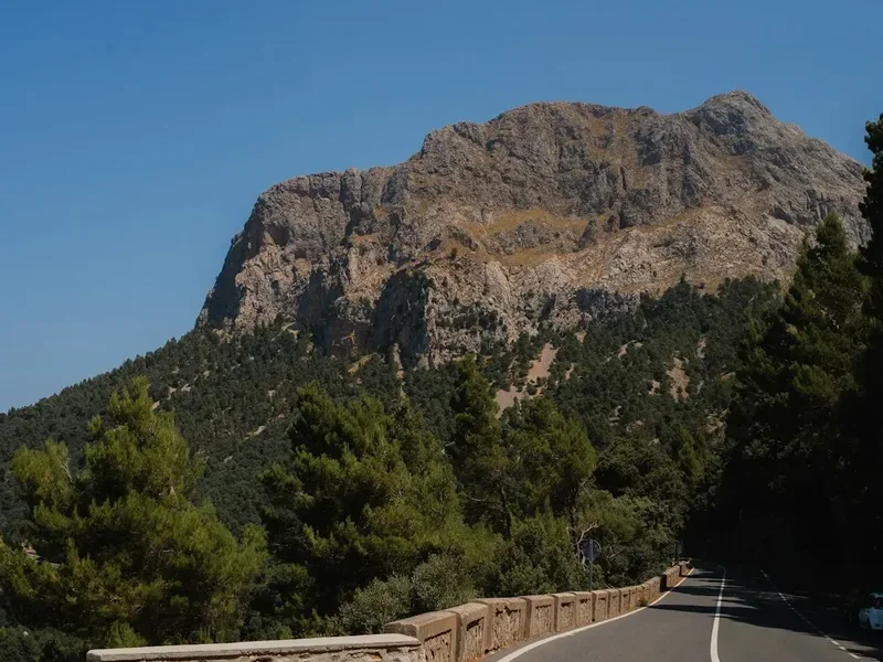
Road Safety: A significant portion of the Camino del Norte involves walking on or alongside paved roads. While many of these are quiet country lanes, some sections follow busy national roads (N-634). Always walk on the left side facing traffic, wear reflective gear if walking in low light, and stay alert. Do not use headphones on road sections.
Weather Hazards: The "España Verde" is beautiful because it rains. Sudden Atlantic storms can bring heavy rain, strong winds, and fog, particularly on the coastal cliffs and mountain passes. Hypothermia is a risk even in summer if you get wet and the wind picks up. Always carry high-quality rain gear and check the forecast (AEMET is the most reliable) before setting out.
Terrain: The Basque sections are very steep. The descents can be slippery when wet, especially on the ancient stone paths (calzadas). Trekking poles are highly recommended to save your knees and provide stability on muddy slopes. In Galicia, the mud can be ankle-deep after heavy rain.
Hydration and Sun: Even though it is cooler than southern Spain, the sun is strong. Dehydration and heatstroke are risks, especially on the long, exposed stretches of Cantabria. Drink plenty of water and use high-factor sunscreen.
Emergency Services: The universal emergency number in Spain is 112. Most areas of the Camino del Norte have good mobile phone coverage, but there are "dead zones" in the remote forests of Asturias and Galicia.
Side Trips and Points of Interest
The Camino Primitivo Link: At Villaviciosa or Casquita, pilgrims can choose to turn inland toward Oviedo. This allows you to visit the Oviedo Cathedral (a historic requirement for many medieval pilgrims) and then continue on the Camino Primitivo, the oldest and most mountainous of all the routes. This is a popular option for those who want to combine the coastal beauty of the Norte with the rugged challenge of the Primitivo.
Cudillero: Often cited as the most beautiful village in Spain, this colourful fishing port is built into a natural amphitheatre. The official Camino path bypasses it, but the 2-kilometre detour is well worth the extra steps for the views and the seafood.
Monastery of Sobrado dos Monxes: This is one of the highlights of the Galician section. The monastery is a massive, imposing structure with a beautiful Baroque façade. Staying in the pilgrim albergue within the monastery cloisters is a highlight for many, offering a glimpse into the monastic life that has supported pilgrims for a millennium.
Mondoñedo: Once one of the seven capitals of the Kingdom of Galicia, this town feels frozen in time. Its cathedral is a mix of Romanesque, Gothic, and Baroque styles, and the town is famous for its "Tarta de Mondoñedo," a rich local pastry made with almonds and pumpkin.
Leave No Trace
The Camino del Norte passes through fragile coastal ecosystems, ancient forests, and private agricultural land. With the increasing popularity of the route, the environmental impact has become a concern. It is the responsibility of every pilgrim to preserve the beauty of the path.
Your responsibility as a pilgrim:
- Pack it out: Never leave litter on the trail. This includes fruit peels and tissues. Carry a small bag for your trash until you reach a bin in the next town.
- Respect the "Flechas": Stay on the marked path. Taking shortcuts through farmers' fields damages crops and creates tension between locals and pilgrims.
- Water Protection: Do not use soap or detergent in natural streams or fountains. Use the facilities provided in albergues.
- Noise Pollution: Many people walk the Camino for silence and reflection. Avoid playing music through speakers and keep your voice down in forests and villages.
- Albergue Etiquette: Follow the rules of the albergue. Keep your gear organised, don't take up extra beds, and be quiet after 10:00 PM.
- Support Local: Buy your supplies from small local shops and eat in village bars. This ensures the economic benefits of the Camino reach the communities that host it.