
Camino Aragonés - The Majestic Pyrenean Gateway
The Camino Aragonés is a profound and historically significant branch of the Camino de Santiago, stretching 170.0 kilometres from the high mountain pass of Somport in the Central Pyrenees to the town of Puente la Reina in Navarre. As one of the primary entry points for medieval pilgrims entering the Iberian Peninsula from France, this route offers a more solitary, rugged, and culturally rich alternative to the more crowded sections of the Camino Francés. The trail begins at an altitude of 1,640 metres, descending through the dramatic glacial valleys of the Aragon River, traversing the arid plains of the Canal de Berdún, and finally winding through the rolling vineyards and olive groves of Navarre. It is a journey of transition—from the granite peaks and alpine meadows of the north to the Mediterranean landscapes of the Ebro basin.
- Distance: 170.0 km one-way
- Duration: 6–9 days
- Elevation Gain: 4,000 m total ascent
- Difficulty: Moderate (high mountain start, followed by rolling terrain)
- Best Time: Spring (April–June) or Autumn (September–October)
- Closest City: Jaca (Aragon)
- Trailhead: Somport Pass (Puerto de Somport)
- End Point: Puente la Reina (confluence with the Camino Francés)
Overview
The Camino Aragonés is often described as the "quiet" Camino. While the French Way (Camino Francés) sees hundreds of thousands of pilgrims annually, the Aragonés remains a path for those seeking introspection, historical depth, and a closer connection to the natural world. The route follows the course of the Aragon River, which served as the cradle of the Kingdom of Aragon in the 11th century. This historical weight is palpable in every Romanesque chapel, fortified village, and ancient stone bridge encountered along the way.
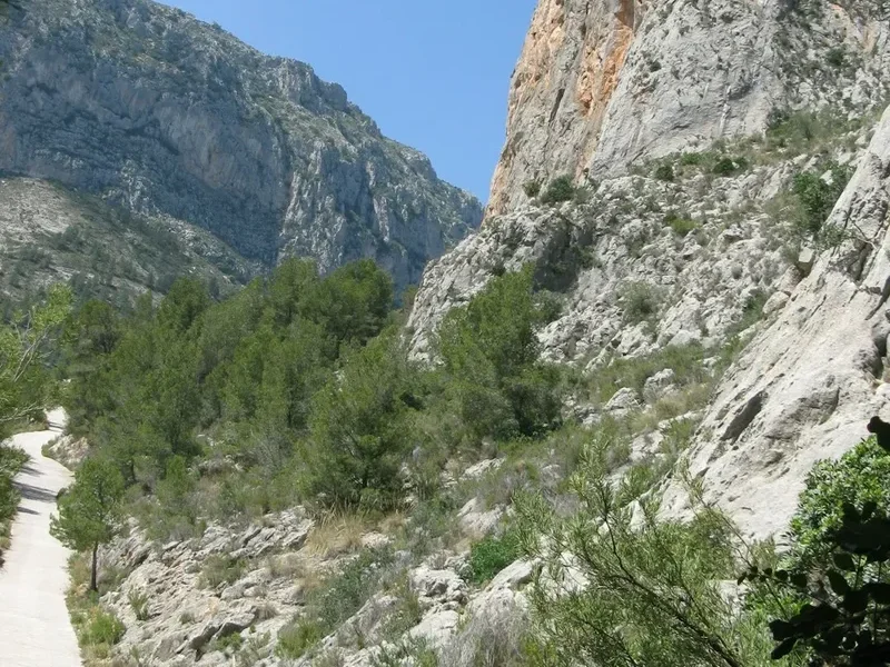
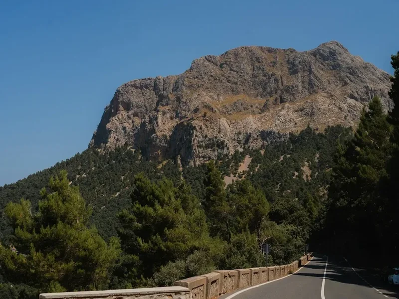
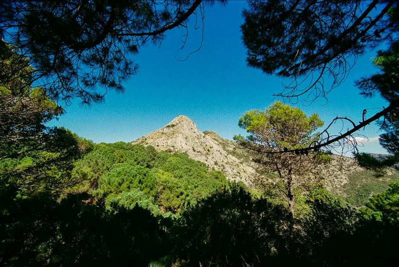
The landscape is the primary protagonist of this trail. Starting at the Somport Pass, walkers are greeted by the jagged peaks of the Pyrenees, where snow can linger well into May. The descent into the Val de Canfranc is steep and dramatic, passing the monumental Canfranc International Railway Station—a relic of early 20th-century industrial ambition. As the trail moves south towards Jaca, the mountains soften into the "Pre-Pyrenees," characterized by limestone gorges and Mediterranean scrub. Beyond Jaca, the route turns west, following the Canal de Berdún. This section is defined by vast horizons, the turquoise waters of the Yesa reservoir, and the haunting beauty of abandoned villages like Ruesta, which stand as silent witnesses to the rural depopulation of the 20th century.
Upon entering the Chartered Community of Navarre, the trail takes on a different character. The arid marls of Aragon give way to the lush forests of the Izco mountains and the fertile valleys surrounding Sangüesa. The final approach to Puente la Reina is a masterclass in medieval architecture, culminating at the Church of Santa María de Eunate—a mysterious octagonal temple standing alone in the fields—and finally the famous six-arched bridge of Puente la Reina, where the Aragonés and Francés routes merge into a single path toward Santiago de Compostela.
For the modern hiker, the Camino Aragonés offers a balanced challenge. The first two days require steady knees for the long descents, while the middle sections demand endurance across sun-exposed plains. However, the infrastructure of "albergues" (pilgrim hostels) is well-established, ensuring that even in the more remote stretches, a warm bed and a communal meal are never more than a day's walk away. This is a trail for the soul, where the rhythm of the footsteps matches the slow unfolding of Spanish history.
History and Cultural Context
The history of the Camino Aragonés is inextricably linked to the birth of Spain as a modern nation. In the early Middle Ages, the Somport Pass (known in Latin as the Summus Portus) was the most popular crossing for pilgrims coming from the heart of Europe via the Via Tolosana (the Arles Route). Unlike the Roncesvalles pass to the west, Somport was considered safer and more accessible during the winter months, leading to the establishment of the Hospital of Santa Cristina de Somport, which the 12th-century Codex Calixtinus described as one of the three most important hospitals in the world, alongside those of Jerusalem and the Great St Bernard Pass.
The route was the primary artery for the Kingdom of Aragon. Jaca, the first major city on the trail, served as the kingdom's first capital. Its cathedral, San Pedro de Jaca, is a cornerstone of Romanesque architecture; its "jaqués" chequerboard pattern became a decorative standard across the entire Camino de Santiago. The trail also passes near the Monastery of San Juan de la Peña, the spiritual heart of Aragon, where legend claims the Holy Grail was hidden for centuries to protect it from the Moorish advance. The monks of the Cluniac order played a vital role in developing the infrastructure of the trail, building bridges and hospices that facilitated the movement of not just pilgrims, but also ideas, art, and commerce between Spain and the rest of Europe.
Culturally, the trail traverses two distinct regions: Aragon and Navarre. In Aragon, the influence of the mountains is reflected in the stone architecture and the "fabla" (Aragonese language) still heard in some valleys. In Navarre, the landscape and culture shift toward the Basque influence, seen in the place names and the robust culinary traditions. The trail is a living museum of the Reconquista, with hilltop fortresses like Arrés and Ruesta designed to guard the frontier. Walking the Camino Aragonés is not merely a physical exercise; it is a journey through the layers of Roman, Visigothic, and medieval Iberian history.
Want more background? Read extended notes on history and cultural context → Learn more
Seasonal Highlights and Weather Reality
The Camino Aragonés is a high-altitude trail at its commencement, which dictates the seasonal window for a safe and enjoyable trek. Unlike the coastal routes, the Aragonés experiences a continental climate with significant temperature fluctuations.
Spring (April to June): This is arguably the best time to walk. The Pyrenean meadows are carpeted in wildflowers, and the Aragon River runs high with snowmelt. Temperatures are mild, typically ranging from 10°C to 22°C. However, walkers must be prepared for late-season snow at Somport and Canfranc. May is particularly beautiful as the beech forests of Navarre begin to leaf out in vibrant green.
Summer (July to August): While the high mountains remain cool, the sections through the Canal de Berdún and the approach to Sangüesa can be punishingly hot. Temperatures frequently exceed 35°C, and there is very little natural shade on the long stretches between villages. If walking in summer, an early start (06:00) is essential to reach your destination before the midday heat. Water management becomes critical during these months.
Autumn (September to October): Another excellent window. The heat of the plains dissipates, and the vineyards of Navarre turn shades of gold and crimson. The weather is generally stable, though the days become noticeably shorter. This is the harvest season, and the local festivals in towns like Jaca and Sangüesa add a vibrant cultural layer to the journey.
Winter (November to March): This is only recommended for experienced winter hikers. The Somport Pass is frequently blocked by snow, requiring the use of the road or snowshoes. Many albergues close during the low season, and the mountain sections can experience sub-zero temperatures and fierce "Tramontana" winds. The beauty of the snow-capped Pyrenees is spectacular, but the logistical challenges are significant.
Recommended Itinerary
6-Day Camino Aragonés Itinerary
Day 1: Somport to Jaca
- Distance: 30.5 km
- Elevation: 50 m gain, 850 m descent
- Time: 7–8 hours
- Start at the Somport Pass (1,640 m) on the French-Spanish border
- Descend through the lush Val de Canfranc, following the Aragon River
- Pass the ruins of the Hospital of Santa Cristina
- Visit the monumental Canfranc International Railway Station
- Continue through the villages of Villanúa and Castiello de Jaca
- Arrive in Jaca, the historic capital of the Kingdom of Aragon
- Key Waypoints: Somport, Canfranc-Estación, Villanúa, Jaca Cathedral
- The long descent can be taxing on the knees; trekking poles are highly recommended
Day 2: Jaca to Arrés
- Distance: 25.4 km
- Elevation: 350 m gain, 400 m descent
- Time: 6–7 hours
- Leave Jaca heading west through the rolling hills of the Pre-Pyrenees
- The trail follows the "Canal de Berdún," a wide tectonic depression
- Pass through the quiet village of Santa Cilia, known for its pilgrim hospitality
- A final steep climb leads to the fortified hilltop village of Arrés
- Arrive in Arrés, offering spectacular 360-degree views of the Pyrenees and the valley
- Key Waypoints: Jaca, Santa Cilia, Puente la Reina de Jaca, Arrés
- The albergue in Arrés is famous for its communal dinners and spiritual atmosphere
Day 3: Arrés to Ruesta
- Distance: 28.4 km
- Elevation: 450 m gain, 500 m descent
- Time: 7–8 hours
- Descend from Arrés into the arid plains of the Aragon valley
- Pass through the village of Martés with its Gothic church
- The trail skirts the southern shore of the Yesa reservoir (the "Sea of Aragon")
- Traverse a rugged, uninhabited landscape of marls and pine forests
- Arrive in Ruesta, a semi-abandoned village with a hauntingly beautiful castle
- Key Waypoints: Arrés, Martés, Artieda, Ruesta
- This is one of the most remote sections; ensure you carry sufficient water and food
Day 4: Ruesta to Sangüesa
- Distance: 22.0 km
- Elevation: 400 m gain, 450 m descent
- Time: 5–6 hours
- Climb through the forests of Mount Peña to the village of Undués de Lerda
- Cross the provincial border from Aragon into the Chartered Community of Navarre
- Descend through agricultural land toward the historic city of Sangüesa
- Arrive in Sangüesa, famous for the portal of the Church of Santa María la Real
- Key Waypoints: Ruesta, Undués de Lerda, Sangüesa
- Sangüesa is a major cultural hub with excellent services and historical monuments
Day 5: Sangüesa to Monreal
- Distance: 27.2 km
- Elevation: 550 m gain, 450 m descent
- Time: 7–8 hours
- Leave Sangüesa and pass the Rocaforte viewpoint
- The trail enters the Izco mountain range, passing through Mediterranean oak forests
- Traverse the villages of Izco and Abínzano
- The silhouette of the Higa de Monreal (1,289 m) dominates the horizon
- Arrive in Monreal, a village at the foot of the mountain with a medieval bridge
- Key Waypoints: Sangüesa, Rocaforte, Izco, Monreal
- The climb to the Izco pass is steady but rewarding with views of the Navarre plains
Day 6: Monreal to Puente la Reina
- Distance: 30.6 km
- Elevation: 300 m gain, 450 m descent
- Time: 8–9 hours
- The final push toward the confluence with the Camino Francés
- Pass through the village of Tiebas with its castle ruins
- Visit the Church of Santa María de Eunate, a unique 12th-century octagonal temple
- Enter the town of Obanos, where the two routes officially meet
- Finish at the medieval bridge of Puente la Reina
- Key Waypoints: Monreal, Tiebas, Enériz, Eunate, Obanos, Puente la Reina
- This is a long day; many pilgrims choose to break it into two by staying in Tiebas or Enériz
Important Notes:
- The route is marked with yellow arrows and scallop shell symbols
- Water fountains are available in most villages, but some stretches are long and dry
- The "Credencial" (Pilgrim Passport) is required to stay in albergues
- Public transport (buses) connects the major towns, but services are infrequent
- The descent from Somport can be slippery in wet weather
Planning and Bookings
Book Your Trip
Everything you need to plan your journey
Accommodation
Find places to stay near Jaca
Flights
Search flights to Jaca
Essential Preparation
The Camino Aragonés requires a higher level of physical preparation than the flatter sections of the Camino Francés. The first day involves a significant descent of 850 metres, which can be strenuous on the joints. Training should include long-distance walks (20–30 km) on varied terrain with a weighted pack. It is also essential to break in your footwear at least two months before departure.
Logistically, Jaca is the best base for the start of the trail. It is well-connected by bus and train to Zaragoza and Huesca. From Jaca, a local bus service (Autocares Valle de Astún) runs several times a day to the Somport Pass. Booking your first night's accommodation in Jaca or at the albergue in Canfranc-Estación is recommended, especially during the peak months of May and September.
Trail Accommodation
The primary form of accommodation on the Camino Aragonés is the "Albergue de Peregrinos." These range from municipal hostels run by local councils to private albergues and those managed by religious orders or associations of "Amigos del Camino."
Hut/Albergue Facilities:
- Dormitory-style rooms with bunk beds (sleeping bags or liners required)
- Shared bathroom facilities with hot showers
- Communal kitchens (facilities vary; some have full stoves, others only microwaves)
- Laundry areas (manual wash basins; some have coin-operated machines)
- Common rooms for socialising and dining
- WiFi is increasingly common but not guaranteed in remote areas
- Costs: Municipal/Parochial albergues (8–12 Euros), Private albergues (15–20 Euros)
What Albergues Don't Provide:
- Bed linen or towels (though some private ones offer them for a fee)
- Toiletries (soap, shampoo, toothpaste)
- Food (unless they offer a "Pilgrim Menu" for an extra charge)
- Privacy (expect shared spaces)
- Late check-ins (most close their doors by 22:00)
Booking Requirements:
- Municipal albergues generally operate on a first-come, first-served basis and cannot be booked
- Private albergues and "pensiones" can and should be booked in advance via phone or apps like WhatsApp
- The "Credencial" is mandatory to access pilgrim-only accommodation
- During the Holy Year (Xacobeo), demand increases significantly
Required Gear
- Hiking boots or trail shoes - must be well-ventilated and have good grip for rocky descents
- Backpack - 30–40L is sufficient for albergue-to-albergue walking; keep total weight under 10% of your body weight
- Sleeping bag liner - silk or lightweight cotton for summer; a light sleeping bag for spring/autumn
- Trekking poles - essential for the Somport descent and the Izco mountains
- Waterproof jacket - lightweight and breathable (Gore-Tex or similar)
- Quick-dry clothing - 2–3 sets of merino or synthetic shirts and socks
- Flip-flops or light sandals - for use in the albergues and showers
- Head torch - for early morning starts and navigating dormitories at night
- First aid kit - focus on blister care (Compeed, needle/thread), antiseptic, and anti-inflammatories
What to Bring
- Credencial (Pilgrim Passport) - can be obtained at the Jaca Cathedral or ordered online
- Water bladder or bottles - minimum 2-litre capacity
- High-energy snacks - nuts, dried fruit, and chocolate for the remote stretches
- Sun protection - SPF 50+ sunscreen, wide-brimmed hat, and sunglasses
- Universal travel adapter - for charging devices in albergues
- Lightweight towel - microfibre for quick drying
- Earplugs and eye mask - essential for sleeping in crowded dormitories
- Biodegradable soap/shampoo - for personal use and hand-washing clothes
- Small amount of cash - many small village bars and albergues do not accept cards
- Offline maps - download the region on Google Maps or use a dedicated Camino app
Permits
There are no formal permits or entry fees required to walk the Camino Aragonés. The trail is a public right of way. However, to utilise the network of pilgrim albergues and to receive the "Compostela" (certificate of completion) in Santiago, you must carry a Credencial del Peregrino.
The Credencial:
- This document acts as your "passport." You must have it stamped at least once a day (twice a day in the final 100 km of the Camino Francés) at albergues, churches, town halls, or bars along the route
- It provides proof of your pilgrim status, allowing you to stay in the low-cost municipal and parochial albergues
- You can obtain a Credencial at the Jaca Cathedral, the pilgrim office in Canfranc, or from various Camino associations in your home country before you travel
- The cost is typically 2–5 Euros
The Compostela:
- While the Camino Aragonés is only 170 km, it counts toward the 100 km minimum required to receive the Compostela in Santiago de Compostela
- You must continue your journey from Puente la Reina along the Camino Francés to Santiago (a further 700 km) to claim the certificate
- If you only walk the Aragonés, you can still receive a certificate of distance or a local certificate from the Jaca or Sangüesa associations
Logistical Considerations:
- No advance booking is required for the trail itself, but if you are travelling in a large group (more than 5 people), it is polite to notify albergues in advance
- Ensure your passport or ID is always with you, as albergues are required by Spanish law to record the details of all guests
Other Activities in the Area
The regions of Aragon and Navarre offer a wealth of experiences beyond the trail. Consider adding a few days to your itinerary to explore:
- Jaca Citadel: A 16th-century pentagonal fortress with a unique moat that is home to a herd of deer. It also houses the Museum of Military Miniatures.
- San Juan de la Peña: Located a short bus or taxi ride from Jaca, this monastery is built directly into a massive rock overhang. It features a world-class Romanesque cloister and the royal pantheon of the Kings of Aragon.
- Canfranc International Station: Take a guided tour of this "Titanic of the Mountains." Recently restored, it is one of the most impressive railway buildings in Europe.
- Wine Tasting in Navarre: The area around Sangüesa and Puente la Reina is famous for its Rosado (rosé) and red wines. Many "bodegas" offer tours and tastings.
- Foz de Lumbier: A spectacular limestone gorge near Sangüesa where you can walk through old railway tunnels and spot griffon vultures nesting in the cliffs.
- Leyre Monastery: A short detour from the trail near the Yesa reservoir, this monastery features an 11th-century crypt and daily Gregorian chants by the resident monks.
Safety and Conditions
Pre-Departure Checks:
- Check the AEMET (Spanish Meteorological Agency) mountain forecast for the Somport area
- Ensure your mobile phone is fully charged and has a Spanish or EU roaming SIM card
- Inform someone of your daily itinerary, especially when crossing the more remote sections like Ruesta
- Verify the opening dates of albergues if travelling in the shoulder or off-season
Weather Hazards: The primary risks are heat exhaustion in summer and hypothermia/snow in winter. The section between Arrés and Ruesta is particularly exposed with no shade for over 15 kilometres. Always carry at least 2 litres of water and wear a hat. In the Pyrenees, thunderstorms can develop rapidly in the afternoon; if you see dark clouds forming over the peaks, seek lower ground immediately.
Terrain and Navigation: The trail is generally well-marked, but the "Canal de Berdún" section has several intersecting farm tracks that can be confusing. Look for the yellow arrows on stones, trees, and telegraph poles. The descent from Somport to Canfranc can be very slippery when wet due to smooth limestone rocks and mud. Take your time and use poles.
Health and Hydration: Blisters are the most common "injury" on the Camino. Treat any "hot spots" immediately with tape or Compeed. Tap water in Spanish villages is generally safe to drink (marked "Agua Potable"), but if a fountain is marked "Agua No Potable," do not use it. In the summer, add electrolyte tablets to your water to prevent salt depletion.
Emergency Services: The universal emergency number in Spain is 112. Operators usually speak English. Most of the trail has good mobile coverage, but there are "dead zones" in the deep valleys of the Pyrenees and the Izco mountains.
Side Trips and Points of Interest
Monastery of San Juan de la Peña: This is the most significant side trip on the Camino Aragonés. While the official trail bypasses it to the north, many pilgrims take a detour from Jaca or Santa Cilia to visit this architectural marvel. The "Old Monastery" is tucked under a colossal red sandstone cliff. Its 12th-century cloister features capitals carved by the "Master of San Juan de la Peña," depicting biblical scenes with haunting, wide-eyed figures. It is a place of immense silence and spiritual power.
Church of Santa María de Eunate: Located just 3 km before Puente la Reina, this 12th-century Romanesque church is one of the most enigmatic buildings on the Camino. It is octagonal in shape, surrounded by a free-standing cloister of arches. Its origins are debated—some link it to the Knights Templar, others to a funerary chapel for pilgrims. Standing alone in a field of grain, it is a perfect place for final reflection before joining the busier main route.
The Abandoned Village of Ruesta: Walking through Ruesta is a poignant experience. Once a thriving village, it was largely abandoned when the Yesa reservoir was built, flooding its best agricultural land. Today, the albergue (run by a trade union) is one of the few inhabited buildings. The ruins of the castle and the Romanesque hermitage of San Juan provide a stark, beautiful backdrop to an evening in the wild.
Sangüesa’s Portal: The south portal of the Church of Santa María la Real in Sangüesa is a masterpiece of medieval art. It is so densely carved with figures of saints, monsters, and daily life that it is often called a "stone Bible." Spend some time identifying the different scenes; it is one of the finest examples of Romanesque sculpture in Spain.
Leave No Trace
The Camino Aragonés passes through fragile ecosystems and historic agricultural landscapes. As a pilgrim, you are a guest in these communities and natural spaces. Practising Leave No Trace principles ensures the trail remains viable for future generations.
Your responsibility as a walker:
- Pack out all trash, including fruit peels and tissues. Do not leave rubbish in the "spiritual" piles of stones (cairns) along the trail
- Use the toilets in bars and albergues. If you must go in nature, bury waste at least 15 cm deep and 60 metres from water sources and the trail
- Stay on the marked path to avoid trampling crops and disturbing the nesting sites of ground-dwelling birds in the Canal de Berdún
- Respect private property. Many sections of the trail pass through working farms; leave gates as you find them
- Do not pick wildflowers or remove stones from historic ruins
- Keep noise levels low, especially when passing through small villages or near churches
- Conserve water and electricity in albergues, as many of these villages face seasonal shortages
The Camino is a journey of gratitude. Leave the trail better than you found it, and respect the local "hospitaleros" who dedicate their lives to supporting pilgrims.