Caminito del Rey - The King's Little Path
The Caminito del Rey, once whispered about in hushed tones as the "world's most dangerous walkway," has undergone a miraculous transformation into one of Spain's most spectacular and safe aerial adventures. Located in the heart of the province of Málaga, within the stunning Desfiladero de los Gaitanes (Gaitanes Gorge), this 7.7-kilometre linear route clings to the sheer limestone walls of a canyon carved by the Guadalhorce River. Suspended 100 metres above the churning turquoise waters, the path offers a bird's-eye view of a geological masterpiece that was millions of years in the making. Originally constructed as a service path for hydroelectric workers at the turn of the 20th century, it now serves as a testament to industrial heritage and natural beauty, drawing travellers from across the globe to experience the thrill of the void from the safety of a modern, engineered boardwalk.
- Distance: 7.7 km total (including access paths and the boardwalk)
- Duration: 3–4 hours
- Season: Year-round (best in April–June and September–October; avoid peak summer heat)
- Difficulty: Challenging (primarily due to height and vertigo; physical exertion is moderate)
- Highest point: Approximately 300 m above sea level (path is 100 m above the river)
- Daily capacity: Strictly limited; tickets must be booked months in advance
- Direction: North to south only (one-way route from Ardales to El Chorro)
Overview
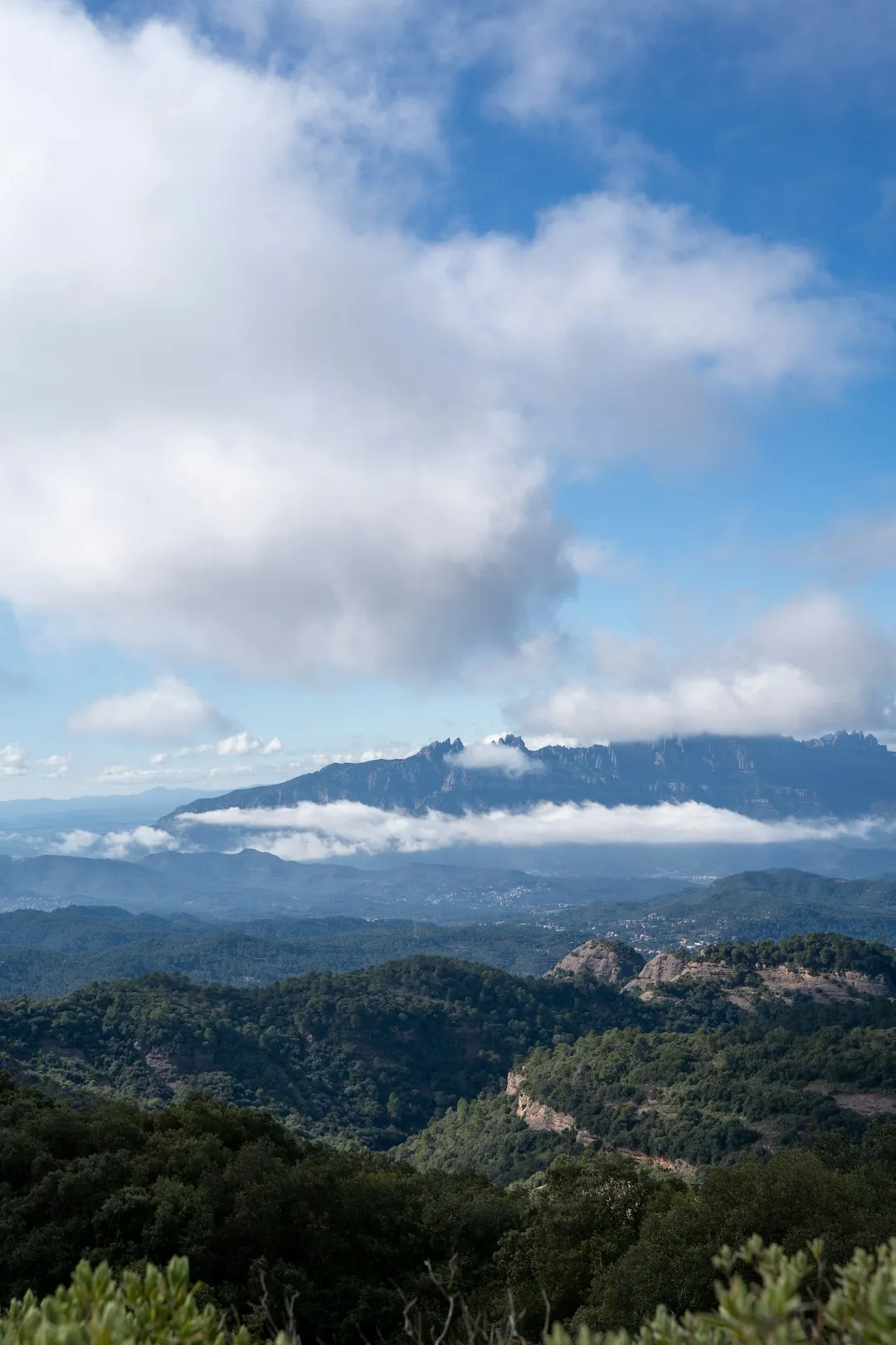
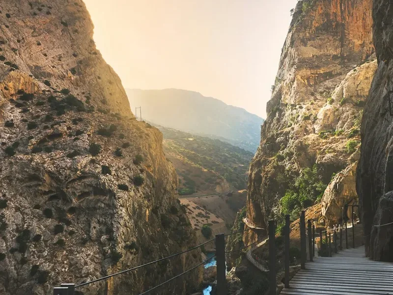
The Caminito del Rey is not merely a hike; it is a journey through the vertical architecture of the Andalusian landscape. The route traverses the Desfiladero de los Gaitanes, a natural canyon carved by the Guadalhorce River through the limestone and dolomite mountains of the Sierra de Huma. The sheer scale of the gorge is difficult to comprehend until you are standing on a wooden boardwalk barely a metre wide, with a vertical drop of 100 metres on one side and a towering cliff face on the other. The experience is defined by three distinct sections: the northern canyon (Gaitanejo), the central valley (El Valle del Hoyo), and the southern canyon (El Chorro), culminating in a heart-stopping crossing of a suspension bridge that spans the width of the gorge.
The modern path, opened in 2015, is built directly above the crumbling remains of the original concrete walkway. This juxtaposition of the old, decaying "Caminito" and the new, secure boardwalk provides a constant reminder of the path's perilous history. While the physical demand of the walk is relatively low—the path is mostly flat or downhill—the psychological challenge is significant. Those with a severe fear of heights (vertigo) will find the experience intense, particularly during the final section where the gorge narrows and the wind can whistle through the limestone narrows. However, for most, the sensation is one of awe rather than fear, as the path reveals hidden waterfalls, ancient fossils embedded in the rock, and the majestic flight of griffon vultures circling overhead.
Access is strictly controlled by a ticketing system, and every visitor is required to wear a safety helmet provided at the entrance. The walk is linear, starting in the municipality of Ardales and finishing in El Chorro (Álora). A shuttle bus connects the two points, making the logistics manageable for day-trippers from Málaga, Seville, or Ronda. This is a landscape where industrial ingenuity meets raw, untamed nature, offering a perspective on the Spanish interior that few other trails can provide.
History and Cultural Context
The origins of the Caminito del Rey are rooted in the industrial revolution of southern Spain. At the beginning of the 20th century, the Chorro Hydroelectric Society (Sociedad Hidroeléctrica del Chorro) needed a way to provide access for workers to maintain the water channels and dams between the Gaitanejo Falls and El Chorro Falls. Construction began in 1901 and was completed in 1905. The path was a marvel of engineering for its time, consisting of concrete slabs supported by iron rails driven into the cliff face. It allowed for the transport of materials and the movement of maintenance crews through a landscape that was previously impassable.
The path gained its royal name in 1921 when King Alfonso XIII of Spain travelled to the site to inaugurate the Conde del Guadalhorce dam. The King walked the entire length of the path, and from that day forward, the locals began calling it "El Caminito del Rey" (The King's Little Path). Over the following decades, however, the path fell into a state of profound disrepair. The concrete crumbled, the handrails vanished, and in many places, only the narrow steel support beams remained. Despite its dangerous condition, the path became a magnet for extreme climbers and adrenaline seekers, earning a reputation as the "most dangerous walkway in the world." Following several fatal accidents in 1999 and 2000, the regional government closed the entrances and demolished the starting sections to prevent access.
After years of planning and a massive restoration project costing over five million euros, the new Caminito del Rey opened to the public in March 2015. The new design prioritised safety while preserving the historical integrity of the site. The original path remains visible beneath the new boardwalk, serving as a haunting museum of early 20th-century engineering. Today, the Caminito is no longer a death-defying feat but a world-class tourist attraction that has revitalised the local economy of the Guadalhorce Valley, proving that heritage and nature can be preserved through sustainable tourism.
Want more background? Read extended notes on history and cultural context → Learn more
Seasonal Highlights and Weather Reality
The province of Málaga enjoys a Mediterranean climate, but the inland location of the Caminito del Rey means it experiences more extreme temperature fluctuations than the coast. Choosing the right time of year is crucial for a comfortable and safe experience.
Spring (March to June): This is arguably the best time to visit. The landscape is vibrant and green, wildflowers bloom in the central valley, and the river flow is often at its peak. Temperatures are typically mild, ranging from 18°C to 25°C, making the walk pleasant without the risk of heat exhaustion. However, spring can bring occasional rain showers, and the path may be closed if winds exceed safety limits.
Summer (July to August): Summer in Andalusia can be brutal. Temperatures frequently soar above 35°C and can reach 40°C in the depths of the gorge where air circulation is limited. The sun reflects off the white limestone walls, creating a furnace-like effect. If you must visit in summer, book the earliest possible time slot (usually 9:00 AM) and carry significant amounts of water. The path offers very little shade, and heatstroke is a genuine risk.
Autumn (September to November): Similar to spring, autumn offers cooler temperatures and stable weather. The intense heat of summer fades by mid-September, and the light becomes softer, which is excellent for photography. The surrounding mountains take on golden hues, and the crowds are slightly thinner than in the peak spring months.
Winter (December to February): Winter is generally mild, with daytime temperatures between 12°C and 18°C. It is a great time for those who prefer a cooler hike. However, winter is also the windiest and wettest season. The Caminito del Rey is strictly managed; if wind speeds at the suspension bridge reach a certain threshold, the path is closed immediately for safety. Always check the official website or your email on the morning of your booking for closure alerts.
Recommended Itinerary
Caminito del Rey Route Progression
Stage 1: Northern Access and The Tunnel
- Distance: 1.5 km or 2.7 km (depending on the tunnel chosen)
- Time: 30–50 minutes
- Start at the "El Kiosko" restaurant area in Ardales
- Choose between the short tunnel (1.5 km walk) or the longer, more scenic pedestrian tunnel (2.7 km)
- Walk through pine forests alongside the turquoise waters of the reservoir
- Arrive at the Control Cabin (Caseta de Control)
- Present your ticket, receive your mandatory safety helmet, and listen to the safety briefing
- This section is a gentle warm-up on a wide, gravel path before the aerial sections begin
Stage 2: Gaitanejo Gorge (The First Canyon)
- Distance: 1 km
- Time: 20–30 minutes
- The boardwalk begins here, pinned to the vertical walls of the first canyon
- Observe the "Cambra" (old hydroelectric houses) built into the rock
- The gorge narrows significantly, with the river rushing far below
- Look for the "Chocolate Pot" (Marmita de Gigante) – a circular hole carved by water and stones
- This is the first real taste of the height and the engineering of the boardwalk
Stage 3: El Valle del Hoyo (The Central Valley)
- Distance: 2.5 km
- Time: 45–60 minutes
- The path leaves the cliffside and transitions into a dirt track through a wide, forested valley
- Pass the ruins of old worker cottages and the remains of the water canal
- Excellent spot for birdwatching; look for eagles and vultures in the thermals above
- This is the only section with significant shade and a few benches for resting
- The valley provides a sense of scale, showing the massive limestone massifs that form the gorge
Stage 4: The Desfiladero de los Gaitanes (The Final Canyon)
- Distance: 1.5 km
- Time: 40–50 minutes
- The most dramatic section of the walk begins as the path returns to the cliff face
- The boardwalk is suspended 100 metres high, offering dizzying views of the river
- Pass the "Glass Balcony" – a transparent section of the floor for the brave
- View the original 1905 path directly beneath your feet
- Observe the fossils of ammonites and other sea creatures embedded in the limestone walls
- The path winds around the "Las Palomas" cliff, leading toward the suspension bridge
Stage 5: The Suspension Bridge and Southern Exit
- Distance: 1.2 km
- Time: 20–30 minutes
- Cross the Puente de Ignacio Mena (Suspension Bridge) – the climax of the route
- The bridge is 35 metres long and can sway slightly in the wind; the views down the gorge are unparalleled
- After crossing, follow the path as it descends toward the railway line
- Walk the final stretch along the cliff edge to the exit control point
- Return your helmet and walk the final 15 minutes to the village of El Chorro
- Catch the shuttle bus back to the northern start point or take the train to Málaga
Important Notes:
- The route is strictly one-way (North to South)
- Allow extra time for the shuttle bus (runs every 30 minutes)
- No toilets are available on the trail itself; use facilities at the start or end
- Smoking and the use of umbrellas are strictly prohibited on the boardwalks
- Children under 8 years of age are not permitted on the trail
- Selfie sticks and tripods are generally discouraged or prohibited for safety reasons
Planning and Bookings
Book Your Trip
Everything you need to plan your journey
Accommodation
Find places to stay near Málaga
Flights
Search flights to Málaga
Essential Preparation
The most critical part of planning a trip to the Caminito del Rey is securing a ticket. Due to its immense popularity and strict daily capacity limits, tickets often sell out three to four months in advance, particularly for weekends and spring/autumn dates. There are two types of tickets: General (self-guided) and Guided (with an official guide and radio headset). If the official website shows no availability, check with authorised tour operators who often have blocks of tickets reserved for guided day trips from Málaga or Seville.
Physically, the walk is accessible to anyone with a basic level of fitness. There are no steep mountain climbs, but there are sections of stairs and the total walking distance is nearly 8 kilometres. The primary "fitness" required is psychological; if you suffer from debilitating vertigo, this trail may not be suitable. Logistics-wise, most visitors base themselves in Málaga city, which is a 40-minute train ride or a 1-hour drive from the trailhead. Alternatively, the white village of Ardales or the climbing hub of El Chorro offer a more rural, immersive experience.
Trail Accommodation
As the Caminito del Rey is a day hike, there is no accommodation on the trail itself. However, there are several excellent options at both the northern and southern ends of the route.
El Chorro (Southern End):
- Complejo Turístico La Garganta: A converted flour mill located right next to the train station. It offers comfortable rooms, a pool, and a restaurant with views of the gorge.
- Olive Branch Guesthouse: A popular choice for climbers and hikers, offering a social atmosphere, bunk beds, and private rooms.
- Camping El Chorro: Located a short distance from the village, providing space for tents and campervans with basic facilities.
Ardales (Northern End):
- Apartamentos Turísticos Parque Ardales: Located near the reservoirs and the start of the access paths. Ideal for families and those wanting to be close to the water.
- Local Guesthouses: The village of Ardales (a 10-minute drive from the trailhead) has numerous traditional Spanish "pensiones" and Airbnb options.
Booking Requirements:
- Accommodation in El Chorro should be booked well in advance during the peak climbing season (winter) and hiking season (spring/autumn).
- Most hotels can assist with shuttle bus information and local dining recommendations.
Required Gear
- Footwear: Sturdy, closed-toe hiking shoes or trainers with good grip. Flip-flops, sandals, and high heels are strictly prohibited and you will be denied entry.
- Clothing: Breathable, moisture-wicking layers. Even in summer, a light windbreaker is useful for the breezy sections of the gorge.
- Sun Protection: A wide-brimmed hat (must be able to fit under or over the safety helmet) and high-factor sunscreen.
- Safety Helmet: Provided by the trail authorities at the entrance; wearing it is mandatory at all times on the boardwalks.
- Small Backpack: A 10–20L pack to carry water and snacks. Large trekking packs are cumbersome on the narrow boardwalks.
What to Bring
- Water: At least 1.5 to 2 litres per person. There are no water fountains on the trail.
- Food: High-energy snacks (nuts, fruit, energy bars) and a light lunch. There are no food outlets once you pass the control cabin.
- Rubbish Bag: There are no bins on the trail. You must carry out all waste, including organic matter like fruit peels.
- Identification: You may be asked to show your passport or ID card to match the name on your ticket.
- Power Bank: Your phone battery will drain quickly as you take photos and videos of the spectacular scenery.
- Personal Medications: Especially if you are prone to allergies or require an inhaler, as the trail is remote.
Permits
The "permit" for the Caminito del Rey is your entry ticket. The management system is highly organised to prevent overcrowding and ensure the safety of the fragile boardwalk structures. Tickets are released in batches, usually several months in advance. It is highly recommended to follow the official Caminito del Rey social media channels or sign up for their newsletter to know exactly when new dates are released.
Ticket Types and Costs:
- General Entrance: €10.00. This allows you to walk the trail at your own pace without a guide.
- Guided Visit: €18.00. Includes a professional guide (available in Spanish and English) and a radio receiver system. This is highly recommended for those interested in the history, geology, and flora of the area.
- Shuttle Bus: Approximately €2.50. This can be purchased as an add-on to your ticket or paid in cash/card on the bus. It is essential for returning to your starting point.
Booking Strategy:
- Visit the official website (caminitodelrey.info) as soon as you know your travel dates.
- If the website is sold out, check the "Train + Entrance" packages offered by RENFE (the Spanish national rail service). These often have separate allocations of tickets.
- Last-minute tickets are occasionally available at the ticket office due to cancellations, but this is extremely risky and not recommended for those travelling from afar.
- Ensure the name on the ticket matches your ID. Tickets are non-transferable and non-refundable in most cases.
Closures and Refunds:
- If the trail is closed due to weather (high winds or heavy rain), you will be notified via email or SMS.
- In the event of a closure, you can usually reschedule your visit for a future date or request a full refund through the official website.
Other Activities in the Area
The region surrounding the Caminito del Rey is a playground for outdoor enthusiasts and culture seekers. Consider spending a few extra days in the area to explore:
- Rock Climbing in El Chorro: One of Europe's premier winter climbing destinations. With over 2,000 bolted routes on world-class limestone, it attracts climbers of all levels. Local schools offer introductory courses for beginners.
- Kayaking and Paddleboarding: The Conde del Guadalhorce and Guadalteba reservoirs near Ardales offer crystal-clear turquoise waters perfect for a relaxing afternoon on the water.
- Bobastro Ruins: Located just a few kilometres from the trail, these are the remains of a 9th-century Mozarabic cave church and fortress built by the rebel Umar ibn Hafsun against the Emirate of Córdoba.
- Ardales Caves (Cueva de Ardales): A prehistoric cave system containing over 1,000 engravings and paintings dating back over 30,000 years. Visits must be booked in advance and are limited to small groups.
- The White Villages (Pueblos Blancos): Explore the nearby villages of Álora, Ardales, and Carratraca for traditional Andalusian architecture, local gastronomy (try the "Sopa Perota"), and thermal baths.
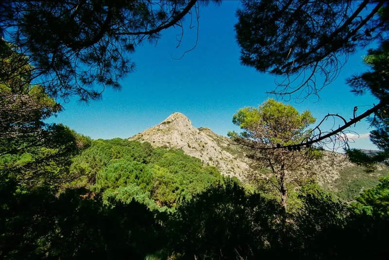
- Hiking the Sierra de Huma: For those who want a more traditional mountain hike, the ascent of Sierra de Huma offers panoramic views of the entire Gaitanes Gorge and the surrounding province.
Safety and Conditions
Pre-Departure Checks:
- Check the official Caminito del Rey website for real-time weather alerts and path status.
- Ensure you have received your booking confirmation and have it downloaded on your phone or printed.
- Confirm the shuttle bus schedule, especially if you are relying on the last train back to Málaga.
- Check the wind forecast; the suspension bridge section is particularly sensitive to gusts.
Vertigo and Height Hazards: The Caminito del Rey is designed to be safe, with high steel railings and a sturdy boardwalk. However, the visual impact of the 100-metre drop is significant. If you experience a panic attack or severe vertigo, stay close to the cliff wall, keep your eyes on the path ahead rather than the void, and inform a trail steward. There are staff members stationed at various points along the boardwalk sections to assist visitors.
Weather Extremes: Heat is the primary safety concern during the summer months. There is no escape from the sun in the canyon sections. Symptoms of heat exhaustion include dizziness, nausea, and excessive sweating. If you feel unwell, find shade in the central valley section and hydrate immediately. In winter, the risk shifts to wind and rain. The limestone can become slippery when wet, and the wind can make the suspension bridge crossing feel unstable. Always follow the instructions of the trail wardens.
Prohibited Items: To ensure the safety of all walkers, the following are strictly banned: umbrellas (they catch the wind), selfie sticks (risk of falling or hitting others), large backpacks, drones, and pets. Smoking is prohibited due to the high risk of forest fires in the arid Andalusian landscape.
Emergency Services: The trail is equipped with a basic first aid system and staff with radio communication. However, due to the vertical nature of the terrain, a full evacuation can be complex and may involve a helicopter. Ensure your travel insurance covers "active tourism" or hiking activities.
Side Trips and Points of Interest
The Glass Balcony: Located in the final canyon section, this small outcropping features a transparent glass floor. It allows you to look directly down between your feet to the river 100 metres below. It is a popular photo spot and a true test of nerves for those who think they have conquered their fear of heights.
Ammonite Fossils: Keep a close eye on the limestone walls as you walk through the Desfiladero de los Gaitanes. The rock was formed under the sea millions of years ago, and you can see beautifully preserved fossils of ammonites (spiral-shelled cephalopods) embedded in the cliff face. They are a silent reminder of the geological history of the Betic Cordillera.
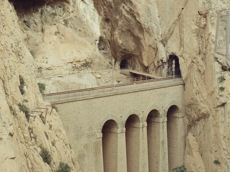
The Old Hydroelectric Bridge: Near the new suspension bridge, you can see the remains of the old bridge used by workers. It is a skeletal structure of rusted iron that highlights the bravery (or desperation) of the men who maintained this system a century ago without modern safety gear.
Griffon Vulture Colonies: The high cliffs of the gorge are home to a large colony of Eurasian griffon vultures. With wingspans of up to 2.8 metres, these massive birds can often be seen soaring on thermals at eye level or nesting in the inaccessible crevices of the rock. Bringing a small pair of binoculars is highly rewarding for bird enthusiasts.
The "Chocolate Pot" (Marmita de Gigante): In the Gaitanejo canyon, look for large, perfectly circular holes in the rock. These were formed over millennia by stones trapped in eddies, which spun around and "drilled" into the riverbed. They are classic examples of fluvial erosion in karst landscapes.
Leave No Trace
The Caminito del Rey is located within the Desfiladero de los Gaitanes Natural Area, a protected space of immense ecological and geological value. With thousands of visitors passing through each week, the impact on the environment can be significant if not managed carefully. As a visitor, you play a vital role in preserving this unique canyon for future generations.
Your responsibility as a walker:
- Carry Out All Trash: There are no bins on the trail. This includes organic waste like apple cores or banana peels, which do not decompose quickly in this arid environment and can attract invasive species or alter the diet of local wildlife.
- Stay on the Path: The boardwalks and designated trails are there to protect the fragile limestone flora. Stepping off the path can crush rare plants and contribute to soil erosion.
- Respect the Wildlife: Do not attempt to feed the birds or lizards. Keep noise levels to a minimum to avoid disturbing nesting raptors like the Bonelli's eagle or the griffon vulture.
- No Graffiti: Carving names into the limestone or the wooden boardwalks is strictly prohibited and causes permanent damage to the site's aesthetic and natural integrity.
- Use Facilities Wisely: Use the toilets at the visitor centres before starting the walk. If you are caught short in the central valley, ensure you are at least 50 metres from any water source and bury waste deeply, carrying out all paper.
- Preserve the Heritage: Do not touch or remove any fossils or historical artefacts from the old hydroelectric works.
By following these principles, you ensure that the Caminito del Rey remains a pristine example of how industrial history and natural beauty can coexist. Take only photos, leave only footprints (on the boardwalk).