Caleta Condor Coastal Trail - Patagonia's Hidden Gem
The Caleta Condor Coastal Trail is a captivating 60 km journey along the rugged Patagonian coastline of Chile, offering a unique blend of windswept beaches, dense Valdivian rainforest, and dramatic ocean vistas. This moderate-difficulty trail winds its way through a landscape sculpted by the relentless Pacific, providing an immersive experience of Chile's wild southern shores. Unlike the more famous Andean treks, Caleta Condor offers a different perspective on Patagonia, one defined by the rhythm of the tides, the calls of seabirds, and the vastness of the ocean horizon. It's a trail that rewards those seeking solitude, natural beauty, and a genuine connection with a less-travelled corner of South America.
- Distance: 60.0 km one-way
- Duration: 3-4 days
- Season: October to April (spring to autumn in Chile)
- Difficulty: Moderate
- Closest City: Osorno
- Trailhead Access: From Osorno, bus to Bahia Mansa (approx. 2 hours). Limited frequency. Taxi or rental car also options.
- Accommodation: Basic campsites and refugios along the route.
- Highest point: Not applicable for this coastal trail.
- Daily walkers: No strict limit, but low visitor numbers ensure solitude.
- Direction: Typically walked from Bahia Mansa towards Caleta Condor, but can be done in reverse.
Overview
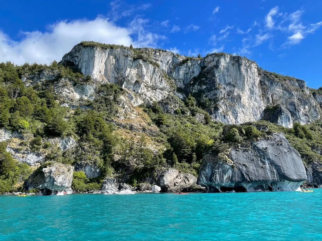
The Caleta Condor Coastal Trail is a testament to the raw, untamed beauty of Chile's southern coastline. Stretching 60 kilometres, it traverses a diverse terrain that shifts from sandy beaches pounded by surf to dense, moss-laden Valdivian temperate rainforest. The trail is a sensory experience: the constant roar of the ocean, the salty spray on your face, the earthy scent of damp forest floor, and the vibrant greens of the ancient trees. It’s a journey that unfolds gradually, revealing hidden coves, dramatic cliff-top viewpoints, and opportunities to spot marine wildlife.
This trail is less about conquering high passes and more about embracing the coastal environment. The elevation gain is modest, spread across the route, making it accessible to a wide range of hikers. The real challenge lies in navigating the sometimes indistinct paths, managing variable coastal weather, and appreciating the subtle beauty of this unique ecosystem. You'll walk along stretches of pristine sand, where the only footprints might be your own and those of seabirds, before plunging into the cool, shaded embrace of the rainforest, where sunlight filters through a canopy of ancient trees.
The trail is not as heavily promoted or regulated as some of South America's more famous treks, which contributes to its appeal for those seeking an authentic, less crowded wilderness experience. It offers a chance to disconnect from the modern world and reconnect with nature in its purest form. The journey culminates at Caleta Condor, a picturesque bay that serves as a fitting reward for the coastal exploration, offering a tranquil setting to reflect on the adventure.
History and Cultural Context
The Caleta Condor Coastal Trail follows ancient pathways used by indigenous peoples for millennia. The Huilliche people, a subgroup of the Mapuche, have inhabited this coastal region for centuries, utilising its rich marine resources and navigating its shores. Their connection to this land is deep, rooted in a profound understanding of the ocean's cycles and the forest's bounty. While the trail itself is not a formalised historical monument, the land it traverses is part of their ancestral territory, and the echoes of their presence can be felt in the quiet solitude of the landscape.
The modern history of this region is tied to the development of small coastal communities and fishing villages that dotted the shoreline. Bahia Mansa, the primary access point, has long been a hub for local fishermen and a gateway to the more remote stretches of coast. The trail likely emerged organically, as local inhabitants and early explorers sought practical routes between these settlements and along the coast for fishing, gathering, and travel. Unlike the grand expeditions that shaped Andean trails, the history here is more grounded, focused on the daily lives and resourcefulness of people living in harmony with a challenging environment.
In recent decades, there has been a growing appreciation for the ecological and scenic value of these coastal areas, leading to efforts to preserve them and promote responsible tourism. The Caleta Condor Coastal Trail represents a move towards showcasing this natural heritage, offering visitors a chance to experience a less-developed, yet equally spectacular, facet of Chilean Patagonia.
Seasonal Highlights and Weather Reality
The best time to walk the Caleta Condor Coastal Trail is during the Chilean spring and autumn, from October to April. This period generally offers the most stable weather, with milder temperatures and less rainfall compared to the harsh winter months.
Spring (October–November): The landscape begins to awaken after winter. Wildflowers start to bloom, and the coastal vegetation becomes vibrant. Birdlife is active, and marine mammals may be more visible as they return to the coast. Temperatures are cool but pleasant, typically ranging from 8°C to 15°C. Days are getting longer, offering ample daylight for hiking.
Summer (December–February): This is the warmest period, with average temperatures between 15°C and 20°C, though heatwaves are rare. Days are long, providing maximum time for exploration. However, summer also brings the highest chance of sandflies, particularly in sheltered, damp areas. Coastal fog can also be a factor, sometimes obscuring views for extended periods.
Autumn (March–April): The colours of the forest begin to change, offering a beautiful spectacle of reds, oranges, and yellows. The air is crisp, and the crowds of summer have thinned. Temperatures start to drop, averaging between 7°C and 14°C. This is an excellent time for photography and for those who prefer cooler hiking conditions. Rainfall can increase towards the end of April.
Winter (May–September): This is the least favourable season for hiking. Temperatures are cold, often dropping below freezing, and rainfall is frequent and heavy. Strong winds are common, and coastal storms can make sections of the trail impassable. Snowfall is possible at higher elevations, though less common directly on the coast. Many of the basic facilities may be closed or have reduced services during this period.
Weather Reality: Regardless of the season, coastal Patagonia is known for its unpredictable weather. Be prepared for rapid changes, including strong winds, rain, and fog, even on seemingly clear days. Layering clothing is essential, and waterproof gear is non-negotiable.
Recommended Itinerary
3-Day Caleta Condor Coastal Trail Itinerary
Day 1: Bahia Mansa to Camping Pescadores
- Distance: 18 km
- Elevation gain: 200 m
- Time: 5–6 hours
- Start at Bahia Mansa, a small fishing port.
- Follow the coastal road for a short distance before the trail turns onto a track.
- Walk along sandy beaches and rocky shorelines.
- Pass through sections of coastal forest.
- Occasional viewpoints offering expansive ocean panoramas.
- Arrive at Camping Pescadores, a basic campsite with facilities.
- Set up camp and enjoy the sounds of the ocean.
Day 2: Camping Pescadores to Refugio Caleta Cóndor
- Distance: 25 km
- Elevation gain: 250 m
- Time: 7–8 hours
- Continue along the coast, with more varied terrain.
- Sections of beach walking interspersed with forest trails.
- The trail may become less distinct in places, requiring careful navigation.
- Pass through dense Valdivian rainforest, with moss-covered trees and ferns.
- Look out for seabirds and potentially marine mammals offshore.
- Arrive at Refugio Caleta Cóndor, a more established shelter with basic amenities.
- This is the longest day, demanding endurance and attention to the trail.
Day 3: Refugio Caleta Cóndor to Trail End (or return to Bahia Mansa)
- Distance: 17 km (to trail end) or 60 km (return to Bahia Mansa)
- Elevation gain: 150 m (to trail end)
- Time: 4–5 hours (to trail end)
- Option 1 (Trail End): Hike the final section to the designated trail end point, often a small cove or access road. From here, arrange transport back to Osorno or your next destination.
- Option 2 (Return to Bahia Mansa): For a more challenging loop or if transport is only available from Bahia Mansa, retrace your steps or follow alternative coastal tracks if available and well-marked. This would require an additional 2-3 days.
- Enjoy the final coastal views and the sense of accomplishment.
- Reflect on the wild beauty of the Caleta Condor coastline.
Important Notes:
- This itinerary is a suggestion; adjust based on your pace and preferences.
- Accommodation is basic – expect campsites and simple refugios.
- Water sources are generally available from streams, but treatment is essential.
- Navigation can be challenging; a map, compass, and GPS device are recommended.
- Weather can change rapidly; always be prepared for rain and wind.
- Transport from the trail end needs to be pre-arranged.
Planning and Bookings
Book Your Trip
Everything you need to plan your journey
Accommodation
Find places to stay near Osorno
Flights
Search flights to Osorno
Essential Preparation
The Caleta Condor Coastal Trail is a more remote and less developed route than many popular South American treks. Thorough preparation is key to a safe and enjoyable experience. The closest major city with good transport links is Osorno. From Osorno, you can take a bus to Bahia Mansa, the typical starting point for the trail. Bus frequency can be limited, so it's advisable to check schedules in advance and allow for flexibility. Hiring a taxi or renting a car are also options, offering more control over your travel times, though rental cars may be more expensive. Road conditions to Bahia Mansa are generally good, but be aware of potential gravel sections, especially as you get closer to the coast.
Logistics for the trail end also need careful consideration. Unlike more established trails, there isn't a single, obvious endpoint with regular transport. You will need to arrange for a pick-up at your chosen trail end point or plan to hike back to Bahia Mansa. This requires pre-booking with local transport providers or having a reliable vehicle waiting. Base town information: Osorno offers a full range of services including accommodation, supermarkets, outdoor gear shops, and transport hubs. Bahia Mansa is a small fishing village with limited services.
Trail Accommodation
Accommodation along the Caleta Condor Coastal Trail is basic and consists primarily of designated campsites and simple refugios (shelters). These are not luxury accommodations and are designed to provide essential shelter in a remote environment.
Camping: Designated camping areas are available at various points along the trail, including near Bahia Mansa and at Camping Pescadores. These sites typically offer a flat area for pitching a tent. Facilities are usually minimal, possibly including a pit toilet and a basic shelter for cooking. You must bring your own tent and all camping gear.
Refugios: Refugios, such as Refugio Caleta Cóndor, offer a more solid shelter, often with bunk beds. These are usually unheated and may have shared sleeping areas. Facilities are basic, typically including a communal cooking area with benches and tables. You will need to bring your own sleeping bag and cooking equipment. Booking for these refugios is often recommended, especially during peak season, though availability can be less formal than on highly regulated trails.
What's NOT Provided:
- Food and drinks
- Cooking equipment (pots, pans, utensils, stoves, fuel)
- Sleeping bags, pillows, or bedding
- Toiletries
- Electricity or charging facilities
- Running water (water sources are natural streams, requiring treatment)
- Showers or hot water
Seasonal Availability: Campsites and refugios are generally accessible from October to April. Outside of this period, they may be unmaintained or closed due to weather conditions. It is advisable to confirm availability and operating status directly with local contacts or park authorities if possible.
Costs: Costs for camping and refugio stays are typically low, often a nominal fee per person per night. Expect prices to be in the range of CLP 5,000 - 15,000 per person per night, but this can vary. It is best to confirm current rates before your trip.
Required Gear
- Sturdy hiking boots: Waterproof, well broken-in boots with good ankle support are essential for varied terrain.
- Waterproof and windproof jacket: A high-quality, breathable jacket is crucial for protection against coastal weather.
- Waterproof overtrousers: Full-length zips are recommended for ease of use.
- Warm layers: Include fleece or down jackets, thermal base layers (merino wool or synthetic), and a warm hat and gloves. Temperatures can drop significantly, especially in the evenings and at higher elevations.
- Backpack: A comfortable backpack of 45-65 litres, with a rain cover, is needed to carry your gear.
- Tent: A durable, waterproof tent suitable for coastal conditions.
- Sleeping bag: Rated for cool to cold temperatures (e.g., 0°C to 5°C comfort rating).
- Navigation tools: A reliable map of the trail, a compass, and a GPS device or smartphone with offline maps are highly recommended. Trail marking can be inconsistent.
- Head torch: With spare batteries, for use in refugios and around camp.
- First-aid kit: Comprehensive kit including blister treatment, pain relievers, antiseptic wipes, bandages, and any personal medications.
- Sun protection: Sunscreen, sunglasses, and a wide-brimmed hat, as the sun can be intense even on cloudy days.
- Insect repellent: Especially important during warmer months to ward off sandflies.
What to Bring
- Food: Sufficient non-perishable food for the duration of your trek, including breakfast, lunch, dinner, and snacks. Lightweight, high-energy options are best.
- Water treatment: A water filter, purification tablets, or a UV steriliser is essential, as all natural water sources must be treated.
- Cooking equipment: Lightweight camping stove, fuel, pot, utensils, plate, bowl, and mug.
- Toiletries: Biodegradable soap, toothbrush, toothpaste, toilet paper, hand sanitiser, and any personal hygiene items.
- Trekking poles: Highly recommended for stability on uneven terrain and descents.
- Dry bags: To keep essential gear dry inside your backpack.
- Camera: To capture the stunning coastal scenery.
- Book or journal: For downtime at camp or in refugios.
- Cash: For any small purchases in Bahia Mansa or for potential transport fees. Card facilities are unlikely to be available on the trail.
- Duct tape and cordage: Useful for repairs.
Permits
The Caleta Condor Coastal Trail does not typically require formal permits in the same way as highly regulated national parks or Great Walks. However, it is always advisable to check with local authorities or park rangers in the Osorno region for any specific regulations or registration requirements before you begin your trek. Some basic registration at the local Carabineros (police) station in Bahia Mansa might be recommended for safety purposes, especially for longer solo trips.
While there are no booking systems for campsites or refugios in the same vein as the Milford Track, it is wise to have a plan for accommodation. During the peak season (December to February), it's a good idea to arrive at campsites or refugios earlier in the day to secure a spot, especially if you are travelling during a public holiday or a busy weekend. For Refugio Caleta Cóndor, if contact information is available, a brief email or phone call to confirm its operational status and any booking procedures would be prudent.
Costs:
- Camping: Expect a small fee per person per night, typically ranging from CLP 5,000 to CLP 10,000.
- Refugios: Refugio stays will likely be slightly more expensive, perhaps CLP 10,000 to CLP 15,000 per person per night.
These are approximate figures and can vary. It is best to carry sufficient Chilean Pesos (CLP) in cash, as card facilities are unlikely to be available on the trail.
Other Activities in the Area
The region surrounding the Caleta Condor Coastal Trail offers several opportunities to enhance your Patagonian experience:
- Exploring Bahia Mansa: Spend time in the charming fishing village of Bahia Mansa. Observe the local fishing boats, enjoy fresh seafood at a local eatery, and soak in the authentic coastal atmosphere.
- Whale and Dolphin Watching: Depending on the season, boat tours may be available from nearby coastal towns or even from Bahia Mansa, offering chances to spot whales, dolphins, and other marine life in the Pacific waters.
- Visiting Parque Nacional Alerce Costero: While a bit of a drive from Bahia Mansa, this national park protects ancient Alerce trees (Patagonian cypress), some of the oldest living trees in the world. It offers different hiking opportunities through unique forest ecosystems.
- Exploring the Dunes of Oncol: Near Bahia Mansa, the Oncol area features impressive coastal dunes and offers different perspectives of the coastline.
- Birdwatching: The coastal environment is rich in birdlife. Keep an eye out for various seabirds, shorebirds, and potentially raptors along the trail and in the surrounding areas.
- Relaxing on the Beaches: Enjoy the solitude of the remote beaches along the trail. While the water is cold, the scenery is spectacular.
Safety and Conditions
Pre-Departure Checks:
- Weather Forecast: Always check the most up-to-date weather forecast for the Osorno coast and Bahia Mansa region before you depart. Coastal weather can be highly variable and change rapidly. MetService or local Chilean meteorological services are good resources.
- Trail Conditions: Information on trail conditions may be limited. If possible, speak to locals in Bahia Mansa or check with any regional park authorities for recent updates on any hazards like fallen trees or washed-out sections.
- Emergency Contacts: Inform someone of your itinerary, including your planned start and end points, expected duration, and when you expect to be back. Provide them with contact details for local emergency services.
Coastal Hazards:
- Tides and Waves: Be aware of tidal patterns, especially when walking on beaches. High tides can make certain sections impassable or dangerous. Never turn your back on the ocean, as rogue waves can occur.
- Slippery Surfaces: Rocks, driftwood, and forest paths can become very slippery when wet, which is common in this region. Wear appropriate footwear and use trekking poles for stability.
- Navigation: Trail marking can be inconsistent. Relying solely on cairns or blazes may not be sufficient. A map, compass, and GPS device are essential. Familiarise yourself with the route before you start.
- Remoteness: The trail is remote, and help may be hours away. Be self-sufficient and prepared for emergencies.
Sandflies: Sandflies are prevalent in coastal and forested areas of Patagonia, especially during warmer months. They are small but persistent biting insects. Use a strong insect repellent containing DEET or picaridin, wear long sleeves and trousers, and consider a head net for maximum protection. They are often most active at dawn and dusk.
Water Safety: All natural water sources must be treated before consumption. Use a reliable water filter, purification tablets, or boil the water.
Wildlife: While large dangerous animals are not a significant concern on this trail, be aware of your surroundings. Marine life can be observed offshore, but maintain a safe distance.
Communication: Mobile phone reception will be unreliable or non-existent for most of the trail. Consider carrying a personal locator beacon (PLB) or satellite messenger for emergencies.
Travel Insurance: Ensure you have adequate travel insurance that covers hiking and potential emergency evacuation.
Side Trips and Points of Interest
Beaches of Bahia Mansa: Before or after your trek, explore the various beaches around Bahia Mansa. These offer opportunities for beachcombing, enjoying the ocean air, and observing coastal birdlife. Some beaches may be accessible via short detours from the main trail.
Coastal Forest Exploration: The Valdivian temperate rainforest is a unique ecosystem. Take time to appreciate the dense undergrowth, the variety of ferns, mosses, and lichens, and the towering trees. Look for signs of native fauna, though they can be elusive.
Marine Wildlife Spotting: Keep a keen eye on the ocean. Depending on the season and luck, you might spot dolphins, sea lions, or even whales. The coastal cliffs can also be excellent vantage points for observing seabirds such as albatrosses, petrels, and cormorants.
Hidden Coves and Rock Formations: The trail often passes by secluded coves and interesting rock formations sculpted by the sea. These offer excellent opportunities for photography and quiet contemplation of the powerful forces of nature.
Views of the Pacific: The trail is designed to offer continuous, albeit sometimes intermittent, views of the vast Pacific Ocean. The changing light, weather, and sea conditions create a dynamic and ever-present backdrop to your journey.
Leave No Trace
The Caleta Condor Coastal Trail traverses a fragile coastal and forest ecosystem. Practicing Leave No Trace principles is paramount to preserving its natural beauty and integrity for future visitors and for the health of the environment.
Your responsibility as a walker:
- Plan Ahead and Prepare: Research the trail, understand its challenges, and pack appropriately. Know the regulations for camping and fires (if permitted).
- Travel and Camp on Durable Surfaces: Stick to marked trails and established campsites. Avoid trampling vegetation, especially in sensitive forest areas.
- Dispose of Waste Properly: Pack out everything you pack in, including all food scraps, wrappers, and toilet paper. Use designated toilet facilities where available, or dig catholes at least 60 metres away from water sources, trails, and campsites.
- Leave What You Find: Do not remove plants, rocks, or any natural objects. Take only photographs and memories.
- Minimise Campfire Impacts: If fires are permitted, use established fire rings. Keep fires small and ensure they are completely extinguished before leaving. Better yet, use a camp stove to minimise impact.
- Respect Wildlife: Observe wildlife from a distance. Never feed animals, as it can harm their health and alter their natural behaviours. Store food securely to prevent attracting animals.
- Be Considerate of Other Visitors: Keep noise levels down, especially in campsites and refugios. Yield to other hikers on narrow sections of the trail.
By adhering to these principles, you help ensure that the Caleta Condor Coastal Trail remains a wild and beautiful place for generations to come.