Bungle Bungles Trek - A Journey Through the Ancient Beehives
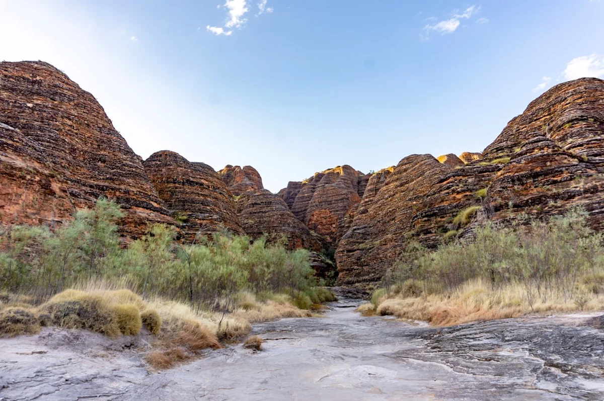
The Bungle Bungles Trek, primarily known as the Piccaninny Gorge Trek, is an immersive wilderness expedition into the heart of Purnululu National Park in Western Australia’s remote Kimberley region. This 54-kilometre multi-day journey is not a traditional "walk" in the sense of a groomed path; rather, it is a challenging navigation through a prehistoric landscape of orange and black striped sandstone domes, deep slot canyons, and vast, sun-bleached creek beds. For over 350 million years, nature has sculpted this terrain into one of the most visually spectacular geological wonders on Earth. Walking here is a profound experience of isolation and scale, where the silence of the desert is broken only by the crunch of river stones beneath your boots and the occasional call of a distant dingo.
The trek follows the winding course of Piccaninny Creek as it carves its way deep into the Bungle Bungle Range. Unlike many of Australia’s other great walks, there are no permanent markers, no hardened campsites, and no facilities once you leave the trailhead. It is a pure wilderness experience that demands self-sufficiency, navigational competence, and a high level of physical endurance. The reward is unparalleled: the opportunity to camp under the brilliant canopy of the Southern Cross, surrounded by the towering "beehive" domes that have become the iconic symbol of the Australian outback. This is a journey for those who seek to disconnect from the modern world and reconnect with the raw, ancient rhythms of the earth.
- Distance: 54.0 km return
- Duration: 4–5 days
- Season: May to September (strictly dry season only)
- Accommodation: Remote wilderness camping (no facilities)
- Highest point: Approximately 350 m (plateau overlooks)
- Difficulty: Challenging (requires navigation and heavy pack carrying over uneven terrain)
- Direction: Return via the same primary creek system with various side-gorge explorations
Overview
Purnululu National Park, a UNESCO World Heritage site, remained largely unknown to the wider world until 1982, when a film crew "discovered" the range from the air. To the Gija people, the traditional owners, the area has been known and cared for as Purnululu for tens of thousands of years. The Bungle Bungles Trek offers the only way to truly penetrate the interior of this range, moving beyond the day-tourist sites like Cathedral Gorge and into the labyrinthine "Fingers" of Piccaninny Gorge.
The landscape is defined by the striking contrast of its colours. The famous stripes of the domes are caused by two different phenomena: the dark grey or black bands are layers of cyanobacteria (blue-green algae) that grow on layers of sandstone where moisture accumulates, while the orange bands are layers of iron oxide that dry out too quickly for the bacteria to survive. This delicate biological and geological balance creates a visual rhythm that changes throughout the day as the sun moves across the sky, shifting from pale ochre to deep, glowing crimson at sunset.
Physically, the trek is a test of resilience. The majority of the walking takes place in the bed of Piccaninny Creek. In the dry season, this is a wide expanse of "shingle"—loose, rounded river stones that shift underfoot, making every kilometre feel like two. As you progress further into the gorge, the walls close in, rising hundreds of metres above the creek bed. The trek culminates in the "Fingers"—five distinct side-chasms that branch off from the main gorge, each offering its own unique micro-environment, hidden waterholes, and sheer-walled cathedrals of stone. Navigating these upper reaches requires scrambling over boulders and finding routes through narrow gaps, providing a sense of exploration that is rare in the modern world.
This is a landscape of extremes. During the day, the Kimberley sun can be relentless, with temperatures frequently exceeding 30 degrees Celsius even in the middle of winter. At night, the desert air cools rapidly, often dropping to near-freezing. The lack of light pollution means the night sky is of a clarity that is difficult to find elsewhere, making the Bungle Bungles one of the premier locations in Australia for stargazing. To walk here is to accept the terms of the desert: respect the heat, manage your water with absolute precision, and move with the patience that a 350-million-year-old landscape deserves.
History and Cultural Context
The Bungle Bungle Range is part of the traditional lands of the Gija and Jaru people. For the Gija, Purnululu is a place of immense spiritual significance, woven into the fabric of the Dreamtime. The name "Purnululu" itself means "sandstone" in the Gija language. The area served as a rich resource during the wet season, providing water, shelter, and a variety of bush foods. Evidence of this long-standing connection can be found throughout the park in the form of rock art, burial sites, and ancient tool-making quarries. The Gija people continue to maintain a strong connection to this land, working alongside park rangers to manage the delicate ecosystem and share their cultural heritage with visitors.
European history in the region began in the late 19th century with the expansion of the pastoral industry. The name "Bungle Bungle" is thought to be a corruption of "bundle bundle," a common name for a type of native grass found in the area, or perhaps a misspelling of the nearby "Bungle" station. For decades, the range was used by stockmen to muster cattle, but its rugged interior remained largely unexplored by non-Indigenous people. The sheer difficulty of the terrain meant that the heart of the range was effectively protected by its own inaccessibility.
The "discovery" of the Bungle Bungles in 1982 by a television crew filming a documentary called *Wonders of Western Australia* sparked an immediate global interest. The unique beauty of the domes was so striking that the area was declared a National Park in 1987 and subsequently inscribed on the UNESCO World Heritage List in 2003. The listing recognises the park's exceptional natural beauty and its outstanding geological value as the most representative example of cone karst in the world. Today, management of the park is a collaborative effort between the Department of Biodiversity, Conservation and Attractions (DBCA) and the Traditional Owners, ensuring that the cultural and natural values of Purnululu are preserved for future generations.
Want more background? Read extended notes on history and cultural context → Learn more
Seasonal Highlights and Weather Reality
The Bungle Bungles Trek is strictly a dry season adventure. Purnululu National Park is typically closed from December to March, and often into April, due to the extreme heat and the unpredictability of the Kimberley wet season. During the wet, the Spring Creek Track—the only road access to the park—becomes impassable, and Piccaninny Creek transforms from a dry stone bed into a raging torrent capable of moving massive boulders.
May to June (Early Dry Season): This is often considered the best time to trek. The landscape is still relatively green following the rains, and there is a higher probability of finding water in the upper reaches of the gorge. Temperatures are warm but manageable, usually ranging from 28 to 32 degrees Celsius. However, the nights can be surprisingly cold, and the creek bed may still have sections of soft sand or mud that make walking more strenuous.
July to August (Peak Dry Season): This is the most popular time for visitors. The weather is consistently clear and dry, with daytime temperatures averaging 30 degrees Celsius and night-time temperatures often dropping below 5 degrees Celsius. Water sources begin to dry up, meaning trekkers must be more strategic about their water management and may need to carry more weight. The clarity of the air during these months provides the best conditions for photography and stargazing.
September (Late Dry Season): As the "build-up" to the wet season begins, temperatures start to climb, often reaching the high 30s or low 40s. The heat becomes a significant safety factor, and water sources are at their lowest. Only highly experienced trekkers comfortable with extreme heat should consider the trek during this month. By October, the park is often on the verge of closing as the risk of heatstroke and bushfires increases.
Regardless of the month, the Kimberley weather is characterised by its intensity. The sun is exceptionally strong, and there is very little shade in the wide creek beds. Trekkers must be prepared for the physical toll of constant sun exposure and the dramatic temperature swings between day and night.
Recommended Itinerary
5-Day Piccaninny Gorge Expedition
Day 1: Piccaninny Carpark to The Elbow
- Distance: 7 km
- Elevation gain: 50 m
- Time: 3–4 hours
- Start at the Piccaninny Creek Carpark, ensuring all registration forms are completed.
- The first few kilometres follow a marked track towards the "Lookout," providing your first close-up views of the beehive domes.
- Once past the lookout, the marked trail ends, and you enter the wide, stony bed of Piccaninny Creek.
- Walking is slow due to the loose river stones (shingle).
- Arrive at "The Elbow," a prominent bend in the creek where the gorge walls begin to rise significantly.
- Set up camp on a sandy bank. This is a relatively short day to allow for the 4WD journey into the park and to acclimatise to the heat and pack weight.
Day 2: The Elbow to Base Camp (The Fingers Entrance)
- Distance: 8 km
- Elevation gain: 100 m
- Time: 5–6 hours
- Continue following the creek bed as it narrows. The domes give way to sheer, vertical sandstone walls.
- The terrain becomes more complex, with large boulders requiring occasional scrambling.
- Pass through "The Window," a natural arch high in the gorge wall.
- Arrive at the entrance to the "Fingers" system. This area is often used as a base camp for the next two nights.
- Locate a suitable campsite on high ground (to avoid any flash flood risk, though rare in the dry).
- Search for nearby water soaks or pools; the availability of water here dictates the comfort of your stay.
Day 3: Exploring the Five Fingers
- Distance: 5–10 km (exploratory)
- Elevation gain: 150 m
- Time: 6–8 hours
- Leave your heavy packs at base camp and explore the side-chasms known as the "Fingers."
- Finger 1 and 2 are known for their narrow slot canyons and deep shade.
- Finger 3 often contains the most reliable water pools and lush vegetation, including ferns and palms.
- Finger 4 and 5 offer more challenging scrambles and spectacular views of the upper plateau.
- This is the highlight of the trek, where the scale and intricacy of the Bungle Bungles are most apparent.
- Return to base camp for a second night under the stars.
Day 4: Base Camp to The Elbow
- Distance: 8 km
- Elevation gain: Minimal (mostly descent)
- Time: 4–5 hours
- Begin the return journey down the main creek bed.
- The perspective changes as you walk away from the heart of the range, with the afternoon light hitting the walls at different angles.
- Take time to explore small side-gorges you may have missed on the way in.
- Re-establish camp at The Elbow or slightly further downstream.
- Enjoy the final night of complete wilderness solitude.
Day 5: The Elbow to Piccaninny Carpark
- Distance: 7 km
- Elevation gain: Minimal
- Time: 3 hours
- The final leg back to the trailhead. The walking feels easier as your pack is at its lightest.
- The domes of the "Bungle Bungle" proper come back into view as the gorge opens up.
- Reach the carpark by mid-morning to avoid the peak heat of the day.
- Complete the sign-out process at the visitor centre before beginning the 4WD exit from the park.
Important Notes:
- This itinerary is flexible; experienced walkers may push further into the gorge on Day 2.
- Water availability is the primary factor in determining campsite locations.
- Always carry a topographical map and a PLB (Personal Locator Beacon).
- The "shingle" walking is physically draining; do not underestimate the time required for short distances.
Planning and Bookings
Book Your Trip
Everything you need to plan your journey
Accommodation
Find places to stay near Kununurra
Flights
Search flights to Kununurra
Essential Preparation
The Bungle Bungles Trek requires meticulous planning due to its extreme remoteness. The first hurdle is transport. Access to Purnululu National Park is via the Spring Creek Track, a 53-kilometre unsealed road that is strictly 4WD only. This track is notorious for its corrugations, creek crossings, and steep gradients; it can take up to three hours to traverse. Ensure your vehicle is in excellent mechanical condition and carries at least two spare tyres, a high-lift jack, and basic recovery gear. If you are using a rental vehicle, verify that your contract permits travel on the Spring Creek Track.
Kununurra is the nearest major town (approximately 250 km away) and serves as the essential base for supplies. You must purchase all food, fuel, and emergency supplies here. There are no shops or fuel stations within the park. Before heading to the trailhead, you must register your trekking plans at the Purnululu Visitor Centre. This is a critical safety requirement. You will need to provide your expected return date and the number of people in your party. Don't forget to "de-register" upon your return to prevent an unnecessary search and rescue operation.
Fitness is paramount. While the elevation gain is modest, carrying a 15–20 kg pack over loose stones in 30-degree heat is exhausting. Your boots must be well broken-in and capable of handling sharp rocks and constant abrasion. Ankle support is highly recommended due to the unstable nature of the creek bed.
Trail Accommodation
There is no formal accommodation on the Bungle Bungles Trek. This is a pure wilderness camping experience. Once you leave the Piccaninny Carpark, you are responsible for finding your own campsites.
Camping Guidelines:
- Camp on durable surfaces such as sand or rock in the creek bed.
- Avoid camping directly under cliffs or overhanging rocks due to the risk of rockfall.
- Ensure your campsite is above the high-water mark, although flash floods are rare in the dry season.
- There are no toilets; you must follow strict Leave No Trace principles for waste disposal (see LNT section).
- No fires are permitted anywhere in the park; you must use a lightweight fuel stove for cooking.
Park Campgrounds (Pre/Post Trek):
- There are two vehicle-accessible campgrounds within the park: Walardi (south) and Kurrajong (north).
- These must be booked online in advance via the Parks WA website. They provide basic facilities: pit toilets and shared water tanks (water must be treated).
- Costs are approximately AU$15 per adult per night.
Required Gear
- Footwear: High-quality hiking boots with excellent grip and ankle support. The "shingle" will destroy cheap footwear.
- Pack: 60–75L capacity with a robust harness system to manage the weight of water.
- Navigation: Topographic map (Purnululu 1:50,000), compass, and a GPS unit. Do not rely solely on a smartphone.
- Emergency Communication: A Personal Locator Beacon (PLB) is mandatory. Satellite phones are also highly recommended.
- Shelter: A lightweight, well-ventilated tent. A fly-only setup is often sufficient in the dry season, but a mesh inner is essential to keep out insects and scorpions.
- Sleeping Gear: A lightweight sleeping bag (rated to 0°C) and a high-quality sleeping mat for insulation from the cold ground.
- Lighting: Head torch with spare batteries.
- Repair Kit: Duct tape, needle and thread, and spare parts for your stove.
What to Bring
- Water Treatment: A high-quality filter (like a Sawyer Squeeze or Katadyn BeFree) plus purification tablets as a backup. Water in the gorge is often stagnant and may contain animal waste.
- Water Storage: Capacity to carry at least 6–8 litres of water. Large bladders plus hard bottles are a good combination.
- Food: Lightweight, high-calorie dehydrated meals. Avoid heavy tins or glass. Bring plenty of salty snacks to replace electrolytes lost through sweat.
- Electrolytes: Powdered electrolyte supplements are essential for preventing dehydration and heat exhaustion.
- Sun Protection: Broad-brimmed hat, high-SPF sunscreen, and long-sleeved, lightweight "fishing-style" shirts.
- First Aid: A comprehensive kit including blister treatment (Leukoplast/Compeed), snake bite bandages, rehydration salts, and any personal medications.
- Toiletries: Biodegradable soap, trowel for waste, and "wag bags" if you prefer to pack out solid waste (highly encouraged in this fragile environment).
Permits
Accessing the Bungle Bungles Trek requires a combination of park entry fees and camping permits. Unlike some of Australia's other Great Walks, there is no "trekking permit" with a daily quota, but you must comply with the general National Park regulations.
Park Entry Fees:
- A standard National Park entry fee applies to all vehicles entering Purnululu. As of 2024, this is AU$17 per vehicle (standard) or AU$10 for concession holders.
- If you are visiting multiple parks in Western Australia, it is often more cost-effective to purchase a Holiday Pass (4 weeks) or an Annual All Parks Pass.
Camping Fees:
- For the nights you spend on the trek (wilderness camping), you must pay a "Backcountry Camping" fee. This is typically arranged at the Visitor Centre upon arrival or can sometimes be pre-paid online.
- For the nights you spend at Walardi or Kurrajong campgrounds (before or after your trek), you must book and pay online in advance. These campgrounds frequently sell out during the peak months of June, July, and August.
Registration:
- The most important "permit" is the voluntary (but strongly encouraged) registration at the Visitor Centre. You will fill out a form detailing your route, party size, emergency contact info, and PLB hex code.
- You must return to the Visitor Centre to sign out. If you do not sign out by your nominated date, the park rangers will initiate an emergency response.
Commercial Filming and Drones:
- The use of drones is strictly prohibited in Purnululu National Park to protect the privacy of other visitors and the cultural values of the Traditional Owners.
- Commercial filming or photography requires a separate permit from the DBCA, which must be applied for well in advance.
Other Activities in the Area
Purnululu National Park offers several other world-class experiences that can be enjoyed before or after your trek:
- Cathedral Gorge: A short, easy walk from the Piccaninny Carpark leads to a massive natural amphitheatre within the domes. The acoustics are incredible, and the scale is breathtaking.
- Echidna Chasm: Located in the northern part of the park, this walk takes you into a narrow cleft in the rock where the walls are only a metre apart but rise 200 metres high. At midday, the sun shines directly into the chasm, turning the walls a brilliant glowing orange.
- Helicopter Flights: To truly appreciate the "beehive" structure of the Bungle Bungles, an aerial perspective is essential. Flights depart from within the park and offer views of the hidden valleys and plateaus that are inaccessible on foot.
- Mini Palms Gorge: A moderately challenging walk in the north of the park that leads to a hidden forest of Livistona palms tucked away at the end of a steep-walled canyon.
- Kununurra and Lake Argyle: After your trek, head back to Kununurra to explore the massive Lake Argyle, take a sunset cruise on the Ord River, or visit the local sandalwood and rum distilleries.
Safety and Conditions
Heat and Dehydration: This is the single greatest risk on the Bungle Bungles Trek. The Kimberley sun is fierce, and the radiant heat from the sandstone walls can make the gorge feel like an oven. You must drink at least 4–6 litres of water per day. Do not wait until you are thirsty to drink. Use electrolyte replacements to maintain your salt balance. If you begin to feel dizzy, nauseous, or stop sweating, find shade immediately and rest.
Water Scarcity: Do not assume there will be water in Piccaninny Creek. In the dry season, the creek is a dry bed. Water is found only in semi-permanent pools in the upper "Fingers" or in hidden soaks. Always check the latest water reports at the Visitor Centre before starting. If the reports are poor, you may need to cache water on Day 1 or carry enough for the entire trip (which is extremely heavy and difficult).
Navigation and Terrain: There are no markers in the gorge. You must be confident using a map and compass. The terrain is rugged; twisted ankles and falls on slippery rocks are common. A PLB is your only lifeline in the event of a serious injury. There is no mobile phone reception anywhere in the park.
Wildlife: While generally shy, the Kimberley is home to several species of venomous snakes, including the King Brown (Mulga) and the Western Brown. Always watch where you step, especially in long grass or when scrambling over rocks. Scorpions and centipedes are common around campsites; always shake out your boots before putting them on. Dingoes are present in the park; store your food securely and never feed them.
Flash Flooding: While rare in the dry season, unseasonal rain can cause rapid rises in water levels within the narrow gorges. If rain is forecast, do not enter the narrow sections of the gorge and move to higher ground.
Side Trips and Points of Interest
The Window: A spectacular natural arch located high in the western wall of Piccaninny Creek, roughly halfway between The Elbow and the Fingers. It provides a perfect frame for the sky and is a landmark for navigators. The climb up to the base of the window is steep and loose but offers a great vantage point over the creek bed.
Black Rock Pool: Located in one of the upper Fingers, this deep, permanent pool is surrounded by dark, lichen-covered rocks. It is one of the most reliable water sources in the range and a beautiful spot for a refreshing (though very cold) swim. The shade here is a welcome relief from the midday sun.
The Five Fingers: Each of the five main side-chasms has its own character. Finger 3 is often cited as the most beautiful, with its lush vegetation and towering walls. Finger 1 is the narrowest, providing a true "slot canyon" experience where you can touch both walls at once. Exploring these requires time and patience, as you will often encounter "chockstones" (large boulders wedged in the canyon) that require careful scrambling to bypass.
The Great Plateau: For the very experienced and fit, it is possible to find routes that lead out of the gorge and onto the top of the Bungle Bungle plateau. This offers a completely different perspective of the range, looking down onto the tops of the domes. This should only be attempted by those with advanced navigation skills and plenty of water.
Leave No Trace
The Bungle Bungles is an incredibly fragile environment. The sandstone domes are held together by a thin crust of cyanobacteria and iron oxide; once this crust is broken, the soft sand underneath erodes rapidly. Your impact here can last for centuries.
Core Principles for Purnululu:
- Carry Out All Waste: This includes food scraps, tea bags, and all packaging. Do not bury trash; animals will dig it up.
- Human Waste: The arid environment means waste does not decompose quickly. You must bury solid waste at least 15–20 cm deep and at least 100 metres away from any watercourses or campsites. Carry out all used toilet paper in a sealed bag.
- Protect Water Sources: Do not use soap or detergent in the pools. Even "biodegradable" soap can kill the delicate aquatic life in these isolated waterholes. Collect water and wash at least 50 metres away from the source.
- Respect the Domes: Never climb on the striped domes. They are structurally weak and culturally significant. Stick to the stony creek beds and established paths.
- No Fires: Use only fuel stoves. Wood is scarce and provides essential habitat for insects and reptiles.
- Leave What You Find: Do not collect rocks, plants, or cultural artefacts. Take only photographs and leave only footprints.