Canada — Queenston
Hike the Bruce Trail, a 900km ribbon of wilderness across Southern Ontario's Niagara Escarpment. This demanding route traverses diverse landscapes, from the ancient limestone cliffs near Niagara Falls to the rugged shores of Tobermory. Expect a 30-45 day adventure through protected ecosystems, offering spectacular panoramas and a true test of endurance.
Distance: 900.0 km
Elevation Gain: 27000 m
Difficulty: Challenging
Duration: 30-45 days
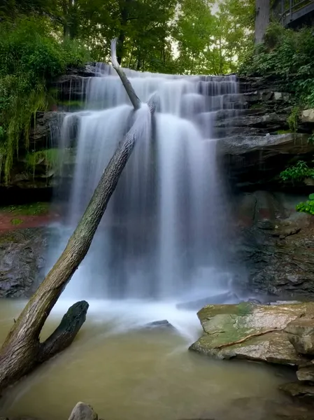
The Bruce Trail is a monumental achievement in Canadian conservation and outdoor recreation, stretching over 900 kilometres along the magnificent Niagara Escarpment in Southern Ontario. This is not merely a hiking path; it is a continuous ribbon of wilderness that traverses one of the most ecologically diverse regions in North America. From the historic heights of Queenston near the roaring Niagara Falls to the rugged, turquoise-shored cliffs of Tobermory on the Bruce Peninsula, the trail offers a journey through ancient cedar forests, over limestone pavements, and past hundreds of cascading waterfalls. As a UNESCO World Biosphere Reserve, the Escarpment provides a sanctuary for rare flora and fauna, including thousand-year-old trees and endangered species, all while remaining accessible to the millions of people living in Canada's most populous corridor. Whether tackled as a multi-month thru-hike or a series of weekend "End-to-End" segments, the Bruce Trail represents a profound connection between the urban landscape and the raw, geological history of the Great Lakes region.
The Bruce Trail is defined by the Niagara Escarpment, a massive geological formation that began taking shape over 400 million years ago. This "Great Arc" of sedimentary rock creates a dramatic landscape of towering cliffs and deep valleys that the trail follows with meticulous precision. Walking the Bruce Trail is an exercise in observing the subtle and dramatic shifts in Ontario's geography. In the south, the trail winds through the lush Carolinian forests of the Niagara Peninsula, where the climate is tempered by the Great Lakes, allowing for a biological diversity found nowhere else in Canada. As the hiker moves north, the landscape transforms into the rugged, windswept beauty of the Georgian Bay shoreline, where the limestone cliffs drop precipitously into crystal-clear, cold waters.
The trail is divided into nine distinct sections, each managed by a local Bruce Trail Club: Niagara, Iroquoia, Toronto, Caledon, Dufferin Hi-Land, Blue Mountains, Beaver Valley, Sydenham, and Peninsula. Each section offers a unique personality. The southern reaches are famous for their proximity to wine country and the spectacular waterfalls of the Hamilton region—often called the "Waterfall Capital of the World." The central sections provide rolling hills and pastoral views of Ontario's heartland, while the northern sections, particularly the Bruce Peninsula, offer the most challenging and rewarding terrain, with technical rocky paths and world-class vistas of the Niagara Escarpment's "spine."
One of the most remarkable aspects of the Bruce Trail is its existence on a mix of public and private land. Unlike many national parks, the Bruce Trail Conservancy (BTC) works with hundreds of private landowners who generously allow the trail to cross their property. This makes the trail a living example of community-led conservation. Hikers are not just visitors to a park; they are guests on a fragile corridor of protected land. The trail is marked by white blazes (main trail) and blue blazes (side trails), a simple but effective navigation system that has guided millions of walkers since the trail's official opening in 1967. To complete the entire 900 kilometres is to witness the full breadth of Ontario's natural heritage, from the southern deciduous forests to the northern coniferous wilderness.
The vision for the Bruce Trail was born in 1960 during a meeting between Raymond Lowes and Robert Bateman. Lowes, a member of the Federation of Ontario Naturalists, proposed a continuous footpath that would protect the Niagara Escarpment from the encroaching urban development of the post-war era. At the time, the Escarpment was seen by many as a source of raw materials for quarrying rather than a natural treasure. The Bruce Trail was conceived as a way to give the public access to the Escarpment, thereby creating a constituency of people who would value and fight for its protection.
The first blaze was painted in 1962, and for the next five years, volunteers worked tirelessly to secure hand-shake agreements with landowners and clear the path through dense bush and over rocky talus slopes. The trail was officially inaugurated in Tobermory in 1967, coinciding with Canada's Centennial year. Since then, the Bruce Trail Conservancy has evolved from a grassroots hiking club into one of Canada's most successful land trusts. The BTC has successfully preserved thousands of acres of Escarpment land, ensuring that the "ribbon of green" remains intact for future generations. In 1990, the Niagara Escarpment was named a UNESCO World Biosphere Reserve, a prestigious international designation that recognises the area's unique ecological importance and the BTC's role in its stewardship.
Beyond its modern history, the land the trail traverses has been home to Indigenous peoples for millennia. The Anishinaabek, Haudenosaunee, and Wendat peoples have deep ancestral connections to the Escarpment. The trail passes through territories covered by various treaties, including the Niagara Purchase and the Dish With One Spoon Wampum Covenant. For Indigenous communities, the Escarpment—often referred to as the "backbone of the turtle"—is a place of spiritual significance, traditional medicine harvesting, and historical travel routes. Recognising this cultural context is an essential part of the modern Bruce Trail experience, as the BTC moves toward more inclusive stewardship and storytelling along the route.
Want more background? Read extended notes on history and cultural context → Learn more
The Bruce Trail is a four-season destination, but the experience changes dramatically with the turning of the calendar. For a thru-hike, the window between May and October is the most practical, though each month within that window offers different rewards and challenges.
Spring (May to mid-June): This is a magical time on the trail. The forest floor is carpeted with trilliums (Ontario's provincial flower), trout lilies, and Dutchmen's breeches. The waterfalls are at their most powerful due to the spring melt. However, this is also "black fly and mosquito season," particularly in the northern sections. Hikers must be prepared for muddy conditions and variable temperatures that can swing from 5°C to 25°C in a single day.
Summer (July to August): The most popular time for hiking, offering long daylight hours and warm temperatures (20°C to 30°C). The canopy provides welcome shade, but the humidity in Southern Ontario can be intense. Water sources can dry up in the heat, making water management critical. In the Peninsula section, the cool breezes from Georgian Bay provide relief, and the turquoise waters are tempting for a post-hike swim, though they remain bracingly cold even in August.
Autumn (September to October): Many consider this the "golden age" of the Bruce Trail. The humidity drops, the biting insects disappear, and the Escarpment erupts in a spectacular display of red, orange, and gold maples. The air is crisp and perfect for long-distance trekking. Early October is peak colour season, but it also brings more crowds to popular lookouts. Night-time temperatures begin to drop toward freezing by late October.
Winter (November to April): While the trail remains open, it becomes a different beast. The limestone rocks become incredibly slippery with ice, and the northern sections can see several metres of snow. Snowshoeing and cross-country skiing are popular on flatter sections, but the cliff-edge portions require micro-spikes or crampons and advanced winter skills. Many amenities and seasonal accommodations close during this period.
Section 1: Niagara (Queenston to Grimsby)
Section 2: Iroquoia (Grimsby to Milton)
Section 3: Toronto (Milton to Cheltenham)
Section 4: Caledon (Cheltenham to Mono Centre)
Section 5: Dufferin Hi-Land (Mono Centre to Lavender)
Section 6: Blue Mountains (Lavender to Craigleith)
Section 7: Beaver Valley (Craigleith to Blantyre)
Section 8: Sydenham (Blantyre to Wiarton)
Section 9: Peninsula (Wiarton to Tobermory)
Planning a Bruce Trail thru-hike or a series of section hikes requires significant logistical coordination. Unlike many wilderness trails, the Bruce Trail passes through a mix of rural and semi-urban areas, meaning you are rarely more than a few kilometres from a road, but accommodation and water can be surprisingly difficult to find. The most essential tool for any hiker is the "Bruce Trail Reference Maps and Guide" or the official Bruce Trail App. These provide up-to-date information on trail reroutes, parking, and water sources.
Fitness is a major factor. While the maximum elevation is not high by global standards, the "Bruce Trail knee" is a real phenomenon caused by the constant stepping up and down over uneven limestone rocks. Training on rocky terrain with a weighted pack is highly recommended. Additionally, joining the Bruce Trail Conservancy as a member not only supports trail maintenance but provides access to organised group hikes and "End-to-End" events where transportation is often coordinated by the clubs.
Accommodation is the most challenging aspect of the Bruce Trail. There is no continuous string of campsites or huts along the 900 km route. Camping is strictly prohibited on the trail except in designated campgrounds, which are few and far between in the southern and central sections.
Accommodation Options:
There is no single "permit" required to hike the Bruce Trail itself. Access to the main trail and side trails is free for all users. However, there are several costs and specific permits associated with the logistics of the hike that must be factored into your planning.
Parking and Day Use Fees: Many of the trailheads are located within Conservation Areas or Provincial Parks. These locations often require a daily vehicle permit or a per-person entrance fee. In popular areas like Hamilton (Spencer Gorge) or the Bruce Peninsula (The Grotto), parking must be reserved online weeks in advance during the peak season. Failure to have a reservation will result in being turned away or receiving a significant fine.
Camping Permits: If you are staying at the backcountry sites in Bruce Peninsula National Park (Stormhaven or High Dump), you must secure a permit through the Parks Canada reservation system. These are extremely competitive. For private campgrounds along the route, standard nightly fees apply, ranging from $30 to $60 per night.
Bruce Trail Conservancy Membership: While not a permit, a BTC membership (approx. $50 annually) is highly recommended. It provides you with the latest trail information, discounts on maps, and the satisfaction of knowing you are contributing to the preservation of the land you are walking on. Members also receive the "Bruce Trail Magazine," which lists seasonal trail closures and reroutes.
End-to-End Badges: For many, the goal is to earn the "End-to-End" badges for each of the nine sections. Once you complete a section, you can submit a log of your hike to the local club along with a small fee (usually $5–$10) to receive a commemorative embroidered patch. Completing the entire 900 km earns you the prestigious "General End-to-End" badge.


Precisely traced GPX for the Bruce Trail, ready for your GPS or favourite mapping app.
The Bruce Trail corridor is packed with cultural and natural attractions that make for excellent rest-day activities:
The Niagara Escarpment Terrain: The most significant safety hazard on the Bruce Trail is the terrain itself. The trail often runs within centimetres of sheer cliff edges. In wet or icy conditions, these limestone surfaces become incredibly slick. Furthermore, the Escarpment is famous for its "crevices"—deep, narrow cracks in the rock that can be hidden by leaves or snow. Always stay on the marked trail and keep children and pets under close supervision.
Ticks and Lyme Disease: Southern Ontario has seen a significant increase in black-legged ticks, which can carry Lyme disease. The Bruce Trail passes through prime tick habitat (tall grass and leaf litter). Hikers should wear long trousers tucked into socks, use repellent, and perform a thorough "tick check" every evening. If you find a tick attached, remove it carefully with tweezers and save it for testing if possible.
Water Safety: Do not drink untreated water from streams or lakes along the trail. The region is heavily agricultural, and runoff can contain pesticides and bacteria. Additionally, Giardia is present in many water sources. Always use a filter or purification method.
Wildlife: While generally safe, hikers should be aware of their surroundings. Black bears are common in the northern sections (Beaver Valley to Tobermory). Store food properly if camping. The Bruce Peninsula is also home to the Massasauga Rattlesnake, Ontario's only venomous snake. They are shy and will generally avoid humans, but hikers should watch where they step and never attempt to handle one. If bitten, seek medical attention immediately, but do not panic; fatalities are extremely rare.
Weather: Summer thunderstorms can be violent, with lightning being a genuine risk on exposed cliff tops. If a storm approaches, descend from the Escarpment edge into the forested valleys. In the shoulder seasons, hypothermia is a risk if you become wet and the temperature drops.
The Grotto (Bruce Peninsula National Park): This is the most famous landmark on the trail. A sea cave carved by the waves of Georgian Bay, featuring stunning turquoise water. It is located on the Peninsula section and requires a timed parking reservation to visit. It is a highlight of any thru-hike.
Lion's Head Lookout: Often cited as the most beautiful view in Ontario, this lookout offers a panoramic vista of the turquoise waters of Isthmus Bay and the white limestone cliffs of the Escarpment. The trail here is rugged but the reward is unparalleled.
Cheltenham Badlands: Located near the Caledon section, these striking red clay hills are a rare geological phenomenon in Ontario. While you cannot walk on the hills themselves to protect them from erosion, a boardwalk offers excellent views.
Eugenia Falls: A 30-metre waterfall in the Beaver Valley section. The trail passes right by the edge of the gorge, offering spectacular views of the water plunging over the Escarpment into the valley below.
Flowerpot Island: Accessible by boat from Tobermory, this island features unique "flowerpot" rock pillars, sea caves, and its own network of hiking trails. It is a perfect day trip after finishing the northern terminus.
The Bruce Trail exists because of the goodwill of landowners and the dedication of volunteers. Protecting this fragile corridor is the responsibility of every hiker. Because the trail is so close to urban centres, it faces immense "people pressure," making Leave No Trace principles more important here than in almost any other wilderness area.
Core Principles for the Bruce Trail: