Brenta Dolomites Circuit
The Brenta Dolomites Circuit is a spectacular multi-day trek through the heart of one of Italy's most dramatic mountain ranges. This challenging route traverses rugged limestone peaks, traverses via ferratas, and offers breathtaking panoramas of alpine lakes, deep valleys, and jagged ridgelines. It is a journey for experienced hikers seeking a true wilderness adventure, combining physical exertion with the awe-inspiring beauty of the Trentino region.
- Distance: 90.0 km
- Elevation Gain: 5500 m
- Duration: 6-8 days
- Difficulty: Challenging
- Best Time: June to September
- Closest City: Trento
- Trailhead Access: Nearest airport: Verona (VRN). Take a bus or train to Trento, then a local bus to Madonna di Campiglio. Driving from Trento takes ~1.5 hours. Parking available in Madonna di Campiglio but can fill up quickly. No permits needed, but rifugio reservations essential.
- Coordinates: 46.1500, 10.9167
Overview
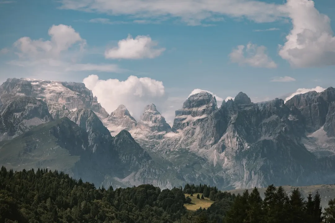
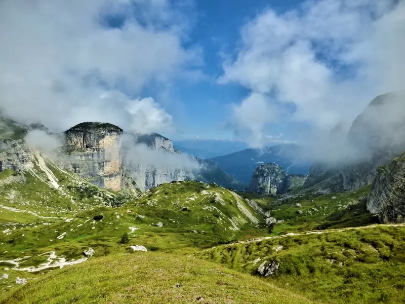
The Brenta Dolomites Circuit is a demanding yet incredibly rewarding trek that circumnavigates the imposing Brenta group, a sub-range of the Italian Alps renowned for its sheer cliffs, pinnacles, and extensive network of via ferratas. This circuit is not a single, clearly marked path but rather a combination of well-trodden trails and protected climbing routes that require a good head for heights and a solid level of fitness. The landscape is characterised by stark, grey limestone, contrasting sharply with vibrant alpine meadows and the deep blue of glacial lakes.
The circuit typically starts and ends in Madonna di Campiglio, a popular ski resort town that serves as an excellent gateway to the Brenta Dolomites. From here, the route ascends into the high alpine environment, passing through a series of mountain huts (rifugi) that offer essential accommodation and sustenance. These rifugi are strategically located to provide access to the most spectacular parts of the range, including iconic peaks like Cima Tosa and Crozzon di Brenta.
The journey involves significant elevation changes, with steep ascents and descents common. Many sections of the circuit incorporate via ferratas – protected climbing routes equipped with steel cables, rungs, and ladders – which allow hikers to safely navigate exposed terrain. While these routes are not technically climbing, they require the use of a via ferrata kit (harness, helmet, lanyard) and a degree of confidence on steep, airy ledges. The views from these high vantage points are unparalleled, offering sweeping vistas across the Brenta range and the surrounding Adamello and Ortler Alps.
The Brenta Dolomites are a UNESCO World Heritage site, recognised for their exceptional natural beauty and geological significance. The unique geological formations, sculpted by millennia of erosion, create a landscape that is both formidable and breathtaking. The circuit offers a deep immersion into this wild and rugged environment, providing a true test of endurance and a profound connection with the alpine world.
History and Cultural Context
The Brenta Dolomites have a rich history intertwined with mountaineering, exploration, and the local culture of Trentino. For centuries, these mountains were primarily the domain of shepherds and hunters, who navigated the lower slopes and valleys. However, with the rise of alpinism in the late 19th and early 20th centuries, the Brenta Dolomites began to attract intrepid climbers and explorers.
Pioneering mountaineers, driven by a spirit of adventure and scientific curiosity, were the first to chart routes up the formidable peaks. Figures like Cesare Battisti, a prominent Italian irredentist and mountaineer, were instrumental in exploring and documenting the region. The construction of the first mountain huts (rifugi) in the early 20th century marked a significant development, providing essential bases for further exploration and making the higher reaches more accessible to a wider range of enthusiasts.
During World War I, the Brenta Dolomites, like many Alpine regions, became a theatre of conflict. The Italian and Austro-Hungarian armies fought for control of strategic positions, and remnants of this period can still be found, including old trenches and fortifications. The development of the via ferrata system in the Brenta Dolomites was significantly influenced by military needs, with many routes initially constructed to facilitate troop movement and supply lines. After the war, these military paths were adapted and maintained for civilian use, becoming a defining feature of the Brenta hiking experience.
The establishment of the Adamello Brenta Nature Park in 1967, and its subsequent inclusion in the UNESCO World Heritage site designation, has underscored the importance of preserving this unique natural and cultural landscape. Today, the Brenta Dolomites continue to be a magnet for hikers, climbers, and nature lovers, drawn by their dramatic beauty, challenging terrain, and the enduring legacy of those who first ventured into these magnificent mountains.
Seasonal Highlights and Weather Reality
The Brenta Dolomites Circuit is best undertaken during the summer months, from June to September. During this period, the weather is generally more stable, and the snow has typically receded from the higher passes and via ferrata routes.
June: Early June can still see significant snow cover at higher elevations, particularly on north-facing slopes and in shaded gullies. Some rifugi may not yet be fully operational, and certain via ferratas might still be impassable due to snow and ice. However, the landscape is often at its most pristine, with wildflowers beginning to bloom, and fewer crowds.
July and August: These are the peak months for hiking in the Brenta Dolomites. The weather is generally warm and sunny, with long daylight hours. However, this is also the season for afternoon thunderstorms, which can develop rapidly and pose a significant hazard, especially on exposed ridges and via ferratas. It is crucial to start your day early to avoid the worst of the heat and the risk of storms. Rifugi are fully open and busy, so advance booking is essential.
September: September offers a beautiful transition into autumn. The crowds thin out, the air is crisp, and the larch trees begin to turn golden, creating a stunning spectacle. The weather can be more unpredictable than in July and August, with a higher chance of cooler temperatures and early snowfalls, especially towards the end of the month. However, clear days in September often provide the most spectacular views.
Weather Considerations: The weather in the Alps can change very quickly. Be prepared for all conditions, including sun, rain, wind, and even snow, regardless of the season. Temperatures can drop significantly at higher altitudes, and wind chill can make it feel much colder. Always check the mountain forecast before setting out each day and be prepared to alter your plans if necessary.
Recommended Itinerary
6-Day Brenta Dolomites Circuit Itinerary
Day 1: Madonna di Campiglio to Rifugio Tuckett / Rifugio S. Antonio (approx. 12 km, 1000 m gain, 4-5 hours)
- Start from Madonna di Campiglio.
- Ascend via chairlift or on foot towards Rifugio Tuckett.
- The initial part of the hike offers stunning views of the Brenta peaks.
- Rifugio Tuckett is a popular base for exploring the northern Brenta.
- Alternatively, continue to Rifugio S. Antonio for a slightly longer day.
- Settle into the rifugio and enjoy the alpine atmosphere.
Day 2: Rifugio Tuckett to Rifugio Brentei (approx. 10 km, 800 m gain, 5-6 hours)
- Descend from Rifugio Tuckett towards the valley floor.
- Begin the ascent towards Rifugio Brentei, a historic rifugio nestled beneath imposing rock faces.
- This day involves traversing through varied terrain, including scree slopes and rocky paths.
- The views of Cima di Brenta and Crozzon di Brenta become increasingly dramatic.
- Arrive at Rifugio Brentei, a key hub for accessing the central Brenta.
Day 3: Rifugio Brentei to Rifugio Pedrotti / Rifugio Alimonta (approx. 8 km, 900 m gain, 6-7 hours)
- A challenging day involving a significant ascent and potentially the first use of via ferrata equipment.
- The route often takes you via the Bocchette Alte or Bocchette Centrali, famous via ferrata routes.
- These routes traverse narrow ledges with steel cables for protection, offering exhilarating exposure.
- The destination is either Rifugio Pedrotti or Rifugio Alimonta, both offering access to the heart of the Brenta.
- Requires a via ferrata kit and a good head for heights.
Day 4: Rifugio Pedrotti / Alimonta to Rifugio Tosa / Rifugio Madonna di Pietracamela (approx. 7 km, 700 m gain, 5-6 hours)
- Continue exploring the high alpine terrain.
- This day might involve further via ferrata sections, potentially including the path towards Cima Tosa.
- The objective is to reach Rifugio Tosa or the nearby Rifugio Madonna di Pietracamela, both situated in a spectacular high-altitude setting.
- Enjoy panoramic views and the feeling of being deep within the mountain range.
- The terrain remains rugged and demanding.
Day 5: Rifugio Tosa / Madonna di Pietracamela to Rifugio Graffer (approx. 15 km, 800 m gain, 6-7 hours)
- A longer day that begins the circuit's return towards Madonna di Campiglio.
- Descend from the high rifugi, potentially via more via ferrata sections or well-maintained trails.
- The route leads towards Rifugio Graffer, another important rifugio in the Brenta system.
- This day offers a mix of challenging ascents and descents, with varied scenery.
- Prepare for a final push on the last day.
Day 6: Rifugio Graffer to Madonna di Campiglio (approx. 10 km, 500 m descent, 3-4 hours)
- The final day of the circuit.
- Descend from Rifugio Graffer back towards Madonna di Campiglio.
- The descent is generally well-marked and less technically demanding than previous days.
- Enjoy the last views of the Brenta Dolomites before returning to civilisation.
- Arrive back in Madonna di Campiglio, completing the circuit.
Note: This itinerary is a suggestion and can be adapted based on fitness levels, weather conditions, and personal preferences. Some hikers may opt for a longer itinerary (7-8 days) to allow for more leisurely exploration or to include additional via ferrata routes.
Planning and Bookings
Book Your Trip
Everything you need to plan your journey
Accommodation
Find places to stay near Trento
Flights
Search flights to Trento
Essential Preparation
The Brenta Dolomites Circuit is a serious undertaking that requires meticulous planning and preparation. Given the challenging terrain, the reliance on rifugi, and the potential for rapidly changing weather, a high level of fitness and experience is paramount. Hikers should be comfortable with multi-day treks, significant elevation gains and losses, and exposed alpine environments. Familiarity with via ferrata techniques and the use of appropriate safety equipment is essential for many sections of the circuit.
Fitness: A strong cardiovascular base is crucial. Regular training that includes hiking with a weighted pack, hill climbing, and endurance activities will prepare you for the demands of the circuit. Practice hiking on uneven terrain to build ankle strength and stability.
Logistics: The primary gateway town is Madonna di Campiglio. This resort town offers a range of accommodation options, from hotels to apartments, and is well-connected by public transport. It is advisable to spend at least one night here before and after your trek to acclimatise, finalise gear, and arrange transport. Parking is available in Madonna di Campiglio, but it can be expensive and fill up during peak season.
Base Town/City Information: Madonna di Campiglio is a vibrant mountain resort with amenities including supermarkets, outdoor gear shops, restaurants, and cafes. It is accessible by bus from Trento, which in turn is connected by train to major Italian cities like Verona and Milan. The journey from Verona to Madonna di Campiglio typically involves a train to Trento followed by a bus connection, taking approximately 3-4 hours in total.
Trail Accommodation
The Brenta Dolomites Circuit relies heavily on a network of mountain huts, known as "rifugi." These provide essential accommodation, meals, and a social hub for hikers. Advance booking for all rifugi is absolutely mandatory, especially during the peak season (July and August).
Rifugi (Mountain Huts):
- Booking Requirements: Reservations must be made well in advance, often months ahead for popular rifugi during peak season. Contact each rifugio directly via their website or by phone. Many have online booking systems.
- Facilities Provided: Dormitory-style sleeping quarters with bunk beds (sheets and blankets are usually provided, but a sleeping bag liner is often recommended), communal dining areas, and often basic Wi-Fi. Hot meals (breakfast, lunch, dinner) are typically available for purchase. Some rifugi have showers, though they may be coin-operated or available only at certain times.
- What's NOT Provided: Personal toiletries, towels, sleeping bags (though liners are common), and personal medications. While meals are available, carrying some of your own snacks and energy bars is advisable.
- Seasonal Availability: Most rifugi are open from mid-June to mid-September. Some may open earlier or close later, but this can vary year to year depending on snow conditions. Always check the specific opening dates for the rifugi you plan to visit.
- Costs: Prices vary but expect to pay approximately €50-€70 per person per night for a bed and half-board (breakfast and dinner). Full board (including lunch) is also usually an option.
Campsites: Wild camping is generally not permitted in the Brenta Dolomites, especially within the nature park boundaries. Stick to designated rifugi for accommodation.
Required Gear
- Via Ferrata Kit: This is non-negotiable for many sections of the circuit. It includes a climbing harness, a helmet, and a via ferrata lanyard with energy absorber. Ensure your kit is certified and in good condition.
- Sturdy Hiking Boots: Waterproof, ankle-supporting hiking boots are essential. Ensure they are well broken-in to prevent blisters.
- Waterproof and Windproof Outerwear: A high-quality waterproof jacket and trousers are vital. The weather can change rapidly, and you may encounter rain, wind, and even snow.
- Warm Layers: Bring a mix of synthetic and wool layers, including a fleece jacket or insulated jacket, and thermal base layers. Temperatures can drop significantly at higher altitudes.
- Gloves and Hat: Essential for warmth, even in summer.
- Backpack: A comfortable, well-fitting backpack of 40-55 litres is suitable for carrying your gear for multi-day treks. A rain cover for your pack is highly recommended.
- Head Torch: With spare batteries, for navigating rifugi at night or for early morning starts.
- First-Aid Kit: Comprehensive kit including blister treatment, pain relievers, antiseptic wipes, bandages, and any personal medications.
- Navigation Tools: Map of the Brenta Dolomites, compass, and a GPS device or smartphone with offline maps. Familiarise yourself with map reading and navigation techniques.
- Sun Protection: High SPF sunscreen, sunglasses, and a wide-brimmed hat. The sun at altitude can be intense.
What to Bring
- Food and Snacks: While rifugi provide meals, carry plenty of high-energy snacks such as nuts, dried fruit, energy bars, and chocolate for during the day's hiking.
- Water Bottles/Hydration Reservoir: Carry at least 2-3 litres of water capacity. Water sources are available at rifugi, but may be less frequent on the trails. Water purification tablets or a filter are a good backup.
- Toiletries: Biodegradable soap, toothbrush, toothpaste, small quick-drying towel, hand sanitiser.
- Sleeping Bag Liner: Many rifugi require these for hygiene.
- Personal Items: Camera, power bank for electronics, book or journal, trekking poles (highly recommended for ascents and descents).
- Cash: While many rifugi accept credit cards, it's wise to carry some Euros for smaller purchases or in case of card machine issues.
- Duct Tape and Cord: Useful for emergency repairs to gear.
Permits
For the Brenta Dolomites Circuit itself, no specific permits are required to hike the trails. The network of trails and via ferratas is generally open to the public. However, access to the Adamello Brenta Nature Park, within which much of the circuit lies, is governed by park regulations aimed at conservation.
Rifugio Reservations: The most critical aspect of "permitting" for this trek is securing accommodation in the mountain huts (rifugi). These huts have limited capacity, and reservations are essential, especially during the peak season (July and August). It is strongly advised to book your accommodation several months in advance, as popular rifugi can fill up quickly.
Via Ferrata Usage: While no specific permit is needed to use the via ferratas, it is imperative to have the correct safety equipment (via ferrata kit) and to understand how to use it. The use of this equipment is implicitly required for safety on many routes.
Park Regulations: While not a permit system, hikers are expected to adhere to the rules and guidelines of the Adamello Brenta Nature Park. This includes respecting wildlife, not disturbing vegetation, packing out all rubbish, and avoiding campfires outside designated areas (which are rare in the high mountains).
Booking Strategy for Rifugi:
- Identify Your Route: Plan your daily stages and the specific rifugi you intend to stay at.
- Contact Rifugi Directly: Visit the official websites of each rifugio. They will have contact information (phone numbers, email addresses) and often online booking portals.
- Book Early: As soon as your dates are confirmed, make your reservations. For peak season, booking 3-6 months in advance is not unreasonable.
- Be Flexible: If your preferred rifugio is full, have backup options or be prepared to adjust your itinerary.
- Confirm Details: When booking, confirm what is included (e.g., bedding, meals) and what you need to bring.
Other Activities in the Area
Beyond the core circuit, the Brenta Dolomites offer a wealth of activities for those looking to extend their stay or explore the region further:
- Via Ferrata Exploration: The Brenta Dolomites are a paradise for via ferrata enthusiasts. Numerous routes of varying difficulty exist, allowing for day trips from rifugi or as part of extended itineraries. Routes like the Via delle Bocchette Centrali and Bocchette Alte are world-renowned.
- Peak Ascents: For experienced climbers and mountaineers, ascents of iconic peaks such as Cima Tosa (3,173 m), Crozzon di Brenta (3,124 m), and Campanile Basso offer significant challenges and incredible rewards. Guided ascents are available for those without extensive climbing experience.
- Hiking and Trekking: Numerous trails exist at lower altitudes and in the surrounding valleys, offering less demanding hikes with beautiful scenery. These can be ideal for rest days or for those seeking gentler exploration.
- Mountain Biking: Madonna di Campiglio and the surrounding areas offer dedicated mountain biking trails and bike parks, catering to various skill levels.
- Paragliding: Experience the Brenta Dolomites from a bird's-eye view with tandem paragliding flights, offering breathtaking aerial perspectives of the rugged landscape.
- Photography: The dramatic landscapes, unique rock formations, and alpine flora provide endless opportunities for photographers. Sunrise and sunset often paint the peaks in spectacular colours.
- Cultural Exploration: Visit local villages in the Trentino region to experience traditional mountain culture, cuisine, and architecture.
Safety and Conditions
Pre-Trip Safety Checks:
- Weather Forecasts: Always check the latest mountain weather forecasts from reliable sources (e.g., Meteo Trentino, national meteorological services) before and during your trek. Be aware of potential for thunderstorms, especially in the afternoon during summer.
- Trail Conditions: Obtain information on current trail and via ferrata conditions. Rifugio staff are an excellent source of up-to-date information. Check for any closures or hazards reported by park authorities or local guides.
- Route Planning: Ensure your planned itinerary is realistic for your fitness level and experience. Factor in potential delays due to weather or unexpected difficulties.
Via Ferrata Safety:
- Equipment: A properly fitted and certified via ferrata kit (harness, helmet, lanyard with energy absorber) is mandatory. Ensure it is in good condition and you know how to use it correctly.
- Technique: Understand how to clip and unclip your lanyards, maintain three points of contact where possible, and move efficiently along the cable.
- Exposure: Be aware of the significant exposure on many via ferrata routes. If you have a severe fear of heights, these sections may be unsuitable.
- Weather: Never attempt a via ferrata during thunderstorms or in heavy rain, as lightning is extremely dangerous, and wet rock can be slippery.
Altitude and Physical Demands: The circuit involves significant elevation changes and can reach altitudes of over 3,000 metres. Be aware of the symptoms of altitude sickness (headache, nausea, dizziness) and descend if symptoms worsen. Ensure you are adequately fit and acclimatised.
Water and Food: Carry sufficient water and snacks. While rifugi provide meals, it's wise to have extra provisions for long hiking days or in case of unexpected delays. Treat water from natural sources if you are not at a rifugio.
Emergency Procedures: Know the emergency contact numbers for the region (e.g., 112 in Italy). Carry a fully charged mobile phone, though reception can be unreliable in mountainous areas. Consider carrying a personal locator beacon (PLB) for remote sections.
Respect the Environment: Adhere to Leave No Trace principles. Stay on marked trails, do not disturb wildlife, and pack out all rubbish. The Brenta Dolomites are a fragile ecosystem.
Side Trips and Points of Interest
Via delle Bocchette Alte: This is one of the most famous and spectacular via ferratas in the Brenta Dolomites. It traverses high along the ridge, offering unparalleled views and exhilarating exposure. It is a challenging route requiring a full via ferrata kit and good fitness. It can be incorporated into the main circuit or undertaken as a dedicated day trip from a rifugio like Rifugio Pedrotti.
Via delle Bocchette Centrali: A slightly less demanding but equally scenic via ferrata that runs parallel to the Bocchette Alte. It offers a fantastic way to experience the high alpine environment and the unique rock formations of the Brenta. Often combined with the Bocchette Alte for a longer, more comprehensive via ferrata experience.
Cima Tosa (3,173 m): The highest peak in the Brenta Dolomites. Ascending Cima Tosa is a serious undertaking, typically requiring advanced mountaineering skills or a guided ascent. The views from the summit are said to be breathtaking, encompassing a vast swathe of the Alps.
Crozzon di Brenta (3,124 m): Another iconic and formidable peak. Its sheer north face is a legendary challenge for rock climbers. While direct ascents are for experienced climbers, the views of its imposing massif from various points on the circuit are a constant highlight.
Lago di Tovel: Located in the lower Val di Non, this beautiful lake is known for its periodic "blooming" phenomenon, where the water turns red due to the presence of algae. While not directly on the circuit, it's a worthwhile detour if you have extra time in the region and are interested in natural phenomena.
Madonna di Campiglio: The starting and ending point of the circuit offers more than just logistical convenience. It's a charming alpine town with excellent restaurants, shops, and opportunities for relaxation after your trek. The surrounding areas also offer activities like golf and horse riding.
Leave No Trace
The Brenta Dolomites are a pristine alpine environment, and it is crucial for all visitors to practice Leave No Trace principles to preserve its beauty and ecological integrity for future generations. The rugged nature of the terrain and the sensitive alpine flora mean that even small impacts can have long-lasting effects.
Plan Ahead and Prepare: Research your route, understand the conditions, and pack appropriately. This includes carrying the necessary safety equipment for via ferratas and being prepared for variable weather. Make reservations for rifugi well in advance.
Travel and Camp on Durable Surfaces: Stick to marked trails and established paths. Avoid cutting switchbacks, as this causes erosion. When resting, choose durable surfaces like rock or gravel. Wild camping is generally prohibited in the high alpine areas and within the nature park.
Dispose of Waste Properly: Pack out everything you pack in. This includes all food scraps, wrappers, and any other litter. Use the designated waste disposal facilities at rifugi. If you must use the toilet in the backcountry, do so at least 70 metres away from water sources, trails, and campsites, and bury human waste.
Leave What You Find: Do not take rocks, plants, or any other natural objects. Leave them for others to enjoy and for the ecosystem to thrive. Do not carve or mark rocks or trees.
Minimize Campfire Impacts: Campfires are generally not permitted in the high alpine areas of the Brenta Dolomites. Use a portable stove for cooking. If a campfire is permitted in a designated area, use existing fire rings and keep fires small.
Respect Wildlife: Observe wildlife from a distance. Never feed animals, as this can disrupt their natural behaviours and diets. Store food securely to prevent attracting animals.
Be Considerate of Other Visitors: Keep noise levels down, especially in rifugi and on trails. Yield to others on narrow paths. Respect the peaceful nature of the alpine environment.