Bluff Knoll - Western Australia's Majestic Summit
Bluff Knoll, or 'Noongar' in the local Noongar language, stands as the highest peak in the Stirling Range National Park, Western Australia. This iconic granite monolith offers a rewarding, albeit challenging, day hike for those seeking panoramic views and a sense of accomplishment. The trail ascends steeply through diverse vegetation, showcasing the unique flora of the region, before culminating at the summit, which provides breathtaking vistas across the surrounding plains and distant mountain ranges. It's a popular destination for sunrise and sunset hikes, offering a dramatic backdrop for photography and contemplation. The journey to the top is a testament to the raw beauty of the Australian landscape, demanding a good level of fitness and preparation.
- Distance: 6.8 km return
- Duration: 3–6 hours
- Elevation Gain: 600 m
- Difficulty: Challenging
- Best Time: Spring (September–November) for wildflowers and cooler temperatures, or Autumn (March–May)
- Closest City: Albany
- Trailhead Access: Nearest city: Albany. Drive ~1.5 hours north via Albany Hwy and Chester Pass Rd. Road is sealed. Ample parking available. No permits required currently. Trailhead GPS: -34.3938, 118.2567. Check park alerts before hiking.
Overview
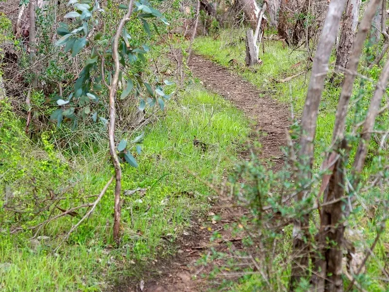
The ascent of Bluff Knoll is a journey through distinct ecological zones, each offering a unique perspective on the Stirling Range's biodiversity. The lower slopes are characterised by hardy shrubs and mallee scrub, adapted to the drier conditions. As the trail climbs, the vegetation transitions to more resilient heathland, dotted with an astonishing array of wildflowers, particularly vibrant during the spring months. The path itself is a well-maintained, though steep, track, often featuring rock steps and switchbacks designed to manage the significant elevation gain.
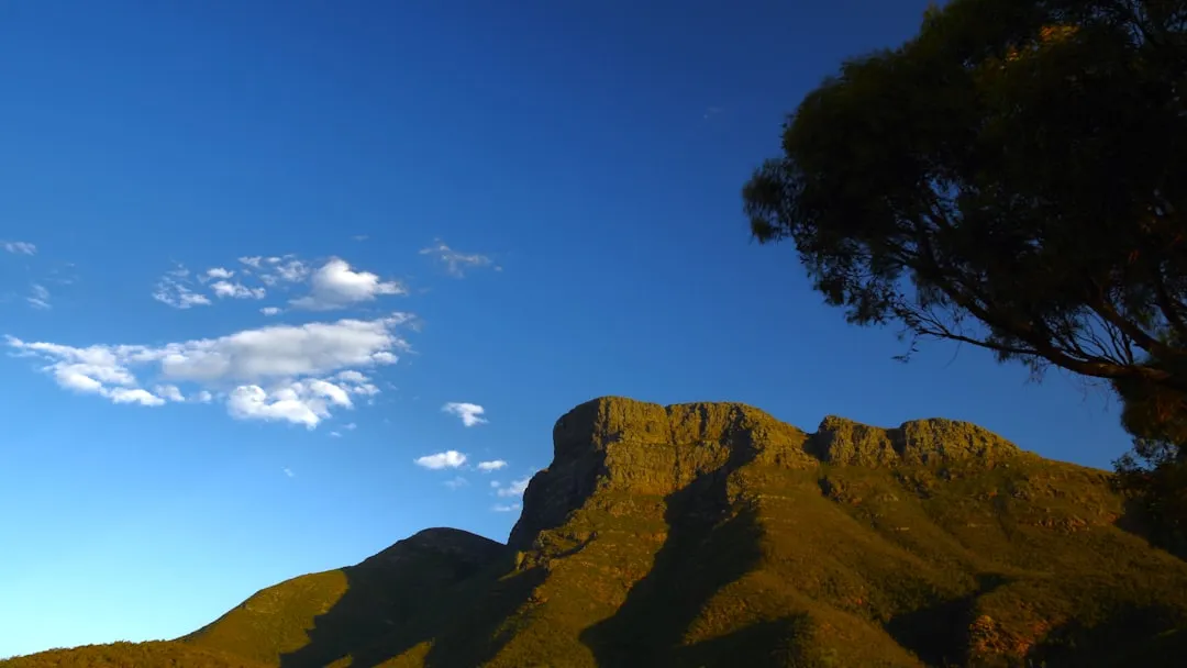
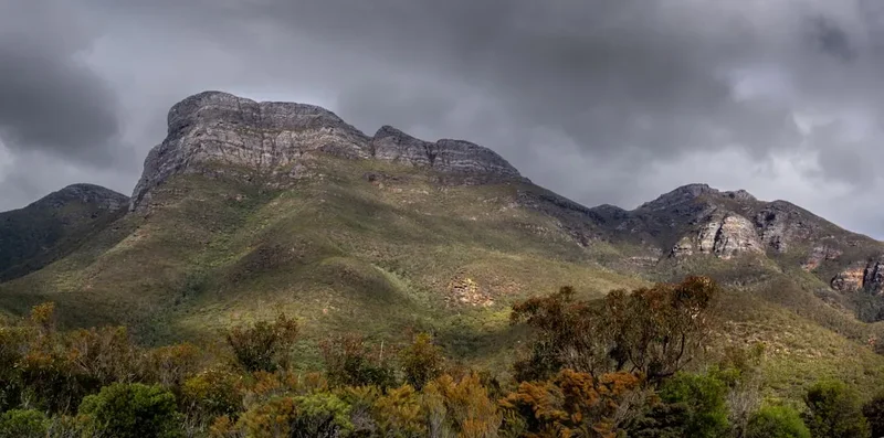
The final approach to the summit involves navigating a series of rocky outcrops and scree slopes. The summit plateau, while relatively flat, is exposed and can be windswept. The reward for the strenuous climb is an unparalleled 360-degree panorama. On a clear day, you can see for kilometres across the wheatbelt plains, the rugged peaks of the Stirling Range stretching out to the east and west, and on exceptionally clear days, the distant coastline near Albany. The sheer scale of the landscape from this vantage point is awe-inspiring, offering a profound connection to the ancient geological formations of Western Australia.
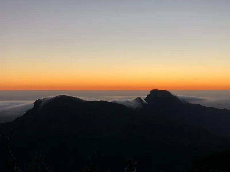
Bluff Knoll is more than just a hike; it's an immersion into a unique environment. The air is often crisp, carrying the scent of eucalyptus and native blossoms. The silence, broken only by the wind and the calls of native birds, provides a stark contrast to the hustle of urban life. It's a place that invites reflection, a physical challenge that yields immense mental and visual rewards. The summit is a popular spot for photographers, particularly at sunrise and sunset, when the changing light paints the landscape in dramatic hues.
History and Cultural Context
The Stirling Range, and Bluff Knoll in particular, holds deep cultural significance for the local Noongar people. The mountain, known as 'Noongar' or 'Boola-Boola' in some dialects, is considered a sacred site, a place of spiritual importance and ancestral connection. For millennia, the Noongar people have lived in harmony with this land, understanding its rhythms, its resources, and its sacred places. The name 'Bluff Knoll' itself is a European descriptor, reflecting the early colonial surveyors' interpretation of the landscape. The Noongar language and traditions are intrinsically linked to the natural features of this region, and it is important for visitors to approach the area with respect for its Indigenous heritage.
European exploration and settlement in the Stirling Range began in the early 19th century. The rugged terrain presented challenges for pastoralists and surveyors alike. The Stirling Range National Park was established in 1916, recognising the unique ecological and geological values of the area. Bluff Knoll, as the highest point, quickly became a focal point for exploration and a symbol of the region's wild beauty. Early visitors would have undertaken the arduous climb with minimal equipment, relying on sheer determination and knowledge of the terrain. The development of the current walking track has made the summit more accessible, but the challenge and the inherent beauty of the climb remain.
The Stirling Range is renowned for its exceptional biodiversity, including a high number of endemic plant species. This rich natural heritage, coupled with its Indigenous cultural significance, makes Bluff Knoll and the surrounding park a vital area for conservation. The ongoing efforts to protect this unique environment ensure that future generations can continue to experience its grandeur and learn from its ancient stories.
Seasonal Highlights and Weather Reality
The Stirling Range experiences a Mediterranean climate, with hot, dry summers and mild, wet winters. Bluff Knoll's summit is exposed and can be significantly cooler and windier than the surrounding plains, so weather conditions can change rapidly.
Spring (September–November): This is arguably the best time to hike Bluff Knoll. The weather is generally mild and pleasant, with average temperatures ranging from 15–25°C. The landscape bursts into colour with an incredible display of wildflowers, including many endemic species unique to the Stirling Range. The risk of extreme heat is lower, making the climb more comfortable.
Autumn (March–May): Another excellent season for hiking. The summer heat subsides, and the weather becomes cooler and more settled. Temperatures typically range from 10–20°C. The autumn colours, though less dramatic than spring wildflowers, can still offer a beautiful palette. This is a good time for clear views and comfortable hiking conditions.
Winter (June–August): Winters are cool and wet, with average temperatures between 8–15°C. While the Stirling Range receives more rainfall than the coast, snow on Bluff Knoll is rare but not impossible, especially at higher elevations. The trails can be slippery and muddy, and visibility may be reduced due to cloud and rain. However, the landscape can be lush and green, and the cooler temperatures are ideal for those who prefer a more challenging, brisk hike.
Summer (December–February): Summers are hot and dry, with temperatures frequently exceeding 30°C and sometimes reaching over 40°C. Hiking Bluff Knoll during the peak of summer is strongly discouraged due to the extreme heat and the risk of heatstroke. If attempting a summer hike, it must be done very early in the morning (before sunrise) or late in the afternoon, with ample water and extreme caution. The trails can be dusty, and the sun exposure is intense.
Weather Considerations: Regardless of the season, always check the weather forecast before you go. The summit of Bluff Knoll is exposed to strong winds, and conditions can change rapidly. Rain can make the rocky sections of the trail slippery and hazardous. Be prepared for all eventualities.
Recommended Itinerary
Bluff Knoll Day Hike Itinerary
Early Morning (e.g., 5:00 AM - 6:00 AM):
- Depart from Albany or your accommodation in the Stirling Range region.
- Drive to the Bluff Knoll trailhead, located off Chester Pass Road.
- Allow approximately 1.5 hours driving time from Albany.
- Arrive at the trailhead car park, ensuring you have sufficient time before sunrise if planning a sunrise hike.
- Final gear check and hydration.
Morning (e.g., 6:30 AM - 10:30 AM): The Ascent
- Begin the hike from the trailhead.
- The initial section involves a steady climb through heathland and low scrub.
- The trail becomes steeper, with well-constructed rock steps and switchbacks.
- Pass through areas with significant wildflower displays during spring.
- The gradient intensifies as you approach the upper slopes.
- Take short breaks to hydrate and admire the changing views.
- The final section involves navigating rocky outcrops and scree.
- Reach the summit plateau.
Midday (e.g., 10:30 AM - 12:30 PM): Summit Experience
- Explore the summit area and enjoy the panoramic views.
- Identify landmarks in the distance, including other peaks of the Stirling Range and the plains below.
- Take photographs and soak in the accomplishment.
- Enjoy a well-deserved snack and rehydrate.
- Be mindful of wind and sun exposure on the exposed summit.
Afternoon (e.g., 12:30 PM - 3:30 PM): The Descent and Return
- Begin the descent, taking care on the steep and rocky sections.
- The descent can be harder on the knees than the ascent; use trekking poles if you have them.
- Continue through the various vegetation zones.
- Arrive back at the trailhead car park.
- Post-hike refreshments and relaxation.
- Drive back to Albany or your next destination.
Alternative Timing (Sunset Hike):
- Start the hike in the late afternoon to reach the summit for sunset.
- Ensure you have a reliable head torch and spare batteries for the descent in darkness.
- Be aware of rapidly dropping temperatures and increased wind chill after sunset.
- Carry appropriate safety gear and inform someone of your plans.
Important Notes:
- This is a challenging day hike requiring good physical fitness.
- Carry at least 2-3 litres of water per person, especially during warmer months.
- Wear sturdy, closed-toe hiking boots with good ankle support.
- Sun protection (hat, sunscreen, sunglasses) is essential year-round.
- Be prepared for rapidly changing weather conditions.
- Check park alerts and weather forecasts before your hike.
Planning and Bookings
Book Your Trip
Everything you need to plan your journey
Accommodation
Find places to stay near Albany
Flights
Search flights to Albany
Essential Preparation
Bluff Knoll is a popular day hike, but its challenging nature means thorough preparation is crucial. The nearest major town with comprehensive services is Albany, approximately 1.5 hours' drive away. It's advisable to base yourself in Albany or a closer accommodation option if available, and ensure you have a reliable vehicle capable of handling sealed roads. Before setting off, check the Department of Biodiversity, Conservation and Attractions (DBCA) website for any park alerts, track closures, or fire bans. The Stirling Range National Park is prone to bushfires, and closures can occur with little notice. Ensure your vehicle has sufficient fuel, as services are limited once you leave Albany or the main highway.
Trail Accommodation
This is a day hike requiring no overnight accommodation.
Required Gear
- Sturdy Hiking Boots: Waterproof and with good ankle support are essential due to the steep, rocky, and sometimes slippery terrain.
- Backpack: A comfortable daypack (20-30 litres) to carry essentials.
- Navigation: While the trail is generally well-marked, a map of the Stirling Range National Park and a compass or GPS device are recommended, especially if planning to explore any side routes or for emergency purposes. A downloaded offline map on your phone is also useful.
- Head Torch: Crucial if hiking for sunrise or sunset, or in case of unexpected delays. Ensure it has fresh batteries and a spare set.
- First Aid Kit: Comprehensive kit including blister treatment, bandages, antiseptic wipes, pain relievers, and any personal medications.
- Sun Protection: Wide-brimmed hat, sunglasses, and high SPF sunscreen. The summit is very exposed.
- Insect Repellent: While not as prevalent as in some other Australian regions, insects can be present, especially during warmer months.
- Trekking Poles: Highly recommended for both the ascent and descent to reduce strain on knees and improve stability.
What to Bring
- Water: Carry a minimum of 2-3 litres of water per person. There are no water sources on the trail.
- Food: High-energy snacks such as trail mix, energy bars, fruit, and sandwiches. Pack enough for your planned duration, plus extra in case of delays.
- Clothing: Wear moisture-wicking base layers. Bring a warm, windproof jacket, even in summer, as conditions at the summit can be cold and windy. A lightweight waterproof jacket is also advisable. Avoid cotton clothing as it retains moisture and can lead to hypothermia.
- Emergency Shelter: A lightweight emergency blanket or bivvy bag can be a lifesaver in unexpected situations.
- Communication Device: A fully charged mobile phone. Note that reception can be patchy in the park. Consider a personal locator beacon (PLB) for remote areas or if hiking alone.
- Rubbish Bag: Pack out everything you pack in, including all food scraps and wrappers.
- Camera: To capture the stunning scenery.
Permits
Currently, no permits are required to hike Bluff Knoll or access the Stirling Range National Park. Entry to the park is free. However, it is always advisable to check the official website of the Department of Biodiversity, Conservation and Attractions (DBCA) for Western Australia for any updates or changes to park access regulations, especially concerning fire bans or track closures.
Park Entry: Free
Trail Access: Open year-round, subject to weather conditions and fire bans.
Important Considerations:
- Bushfire Season: The Stirling Range is a high-risk area for bushfires, particularly during the warmer months (spring, summer, and early autumn). Always check for Total Fire Ban days and park closures before you travel. Information is usually available on the DBCA website or through local fire authorities.
- Track Conditions: While the main trail to Bluff Knoll is generally well-maintained, heavy rain can make sections slippery and hazardous. Check for any specific track alerts.
- Vehicle Access: The road to the Bluff Knoll trailhead is sealed and accessible by 2WD vehicles. Ensure your vehicle is in good condition and has sufficient fuel.
Other Activities in the Area
The Stirling Range National Park and its surrounds offer a variety of activities for nature enthusiasts:
- Other Stirling Range Hikes: Explore other trails within the park, such as the Mount Trio Trail (a shorter, less strenuous climb with excellent views) or the Toolbrunup Peak Trail.
- Wildflower Viewing: The Stirling Range is a biodiversity hotspot, particularly famous for its spectacular array of endemic wildflowers. Spring (September to November) is the prime time to witness this natural spectacle.
- Birdwatching: The park is home to a diverse range of bird species, including the endangered Western Ground Parrot and the Masked Finch.
- Scenic Drives: Enjoy the picturesque drives through the park and the surrounding agricultural landscapes. The drive from Albany to the Stirling Range offers changing scenery.
- Albany Attractions: The nearby city of Albany provides numerous attractions, including the National Anzac Centre, the historic whaling station at Discovery Bay, the stunning coastline at Torndirrup National Park (The Gap and Natural Bridge), and beautiful beaches.
- Porongurup National Park: Located south of the Stirling Range, this park features the unique Granite Skywalk on Castle Rock, offering different but equally impressive views.
Safety and Conditions
Pre-Hike Checks:
- Weather Forecast: Always check the latest weather forecast for the Stirling Range region and specifically for Bluff Knoll. Conditions can change rapidly, especially at higher elevations. MetService or the Bureau of Meteorology (BOM) are reliable sources.
- Park Alerts: Visit the DBCA website for any alerts regarding track closures, fire bans, or other safety information for Stirling Range National Park.
- Bushfire Risk: Be acutely aware of the bushfire risk, especially during warmer months. If a Total Fire Ban is in place, or if there are any fire warnings, do not attempt the hike.
On the Trail:
- Stay on the Track: The marked trail is designed for safety and to protect the fragile environment. Wandering off-track can lead to injury and damage to vegetation.
- Water Supply: Carry more water than you think you will need. Dehydration is a serious risk, especially on hot days.
- Footwear: Ensure your hiking boots are well-fitting and provide adequate support. Loose rocks and uneven surfaces can lead to ankle injuries.
- Sun Protection: The summit is very exposed. Wear a hat, sunglasses, and apply sunscreen regularly.
- Wind: The summit can be extremely windy. Be prepared for strong gusts, which can affect balance.
- Hypothermia: Even on warm days, the temperature can drop significantly at the summit, especially if it becomes cloudy or windy. Carry extra layers of warm clothing.
- Communication: Mobile phone reception can be unreliable within the park. Inform someone of your hiking plans, including your expected return time. Consider carrying a Personal Locator Beacon (PLB) if hiking alone or in remote areas.
- Wildlife: While Bluff Knoll is not known for dangerous wildlife, be aware of your surroundings. Snakes can be present, especially during warmer weather.
Emergency Procedures: In case of an emergency, call Triple Zero (000). Be prepared to provide your exact location, the nature of the emergency, and the number of people involved.
Side Trips and Points of Interest
Summit Views: The primary "side trip" is simply exploring the summit plateau itself. Take your time to walk around and appreciate the different vantage points. The 360-degree panorama is the main attraction, offering expansive views of the Stirling Range and the surrounding landscape.
Wildflower Displays: During spring (September to November), the slopes of Bluff Knoll are adorned with a spectacular array of wildflowers. While not a specific detour, actively looking for these unique species as you ascend and descend is a rewarding experience. Keep an eye out for the Stirling Range Flame (Anigozanthos pulcherrimus) and various species of Banksia, Hakea, and native orchids.
Geological Formations: Observe the unique granite formations and the way the trail has been carved through the rock. The sheer scale of the mountain and the evidence of ancient geological processes are points of interest in themselves.
Sunrise/Sunset Viewing: While not a side trip in the traditional sense, timing your hike to coincide with sunrise or sunset offers a dramatically different and highly rewarding experience. The changing light casts long shadows and paints the landscape in vibrant colours, making for exceptional photographic opportunities. Ensure you have adequate lighting and safety precautions if hiking in low-light conditions.
Leave No Trace
The Stirling Range National Park, including Bluff Knoll, is a precious natural environment that requires careful stewardship. Adhering to Leave No Trace principles ensures that this beautiful landscape remains pristine for future visitors and for the health of its unique ecosystems.
Plan Ahead and Prepare: Research the trail, weather conditions, and any park regulations before your visit. Pack appropriately for the conditions and carry sufficient water and food.
Travel and Camp on Durable Surfaces: Stick to the marked trail at all times. The vegetation on the slopes of Bluff Knoll is fragile and can be easily damaged. Avoid creating new paths or shortcuts.
Dispose of Waste Properly: Pack out everything you pack in. This includes all food scraps, wrappers, tissues, and any other litter. There are no bins on the trail or at the trailhead. Use the provided toilet facilities at the trailhead if available, or follow proper backcountry toilet procedures if necessary (though for a day hike, packing out all waste is preferred).
Leave What You Find: Do not remove any natural items, such as rocks, flowers, or plants. Take only photographs and memories.
Minimise Campfire Impacts: Not applicable for this day hike, as campfires are not permitted in the park.
Respect Wildlife: Observe wildlife from a distance. Do not feed any animals, as this can disrupt their natural behaviour and diet. Be aware of snakes and give them plenty of space.
Be Considerate of Other Visitors: Keep noise levels down, especially during sunrise and sunset hikes. Yield to other hikers on the trail, particularly on narrow sections.