Blue Mountains Walkabout - A Journey Through Ancient Country
The Blue Mountains Walkabout is not merely a hike; it is an immersive cultural and ecological odyssey located within the Greater Blue Mountains World Heritage Area of New South Wales, Australia. Spanning approximately 8.0 kilometres, this moderate-grade circuit offers a profound connection to the landscape of the Darug and Gundungurra people. Starting and ending at the historic Faulconbridge Railway Station, the trail descends from the sandstone ridges into the lush, temperate rainforests of the Sassafras Gully. Unlike many standard bushwalks in the region, the Walkabout emphasises the "Songlines" and the deep spiritual heritage of the land, inviting walkers to slow down and observe the intricate relationships between the geology, flora, and fauna of this ancient continent. Over the course of four to six hours, participants traverse dramatic sandstone overhangs, stand beneath towering turpentine trees, and listen to the mimicry of the superb lyrebird in the damp valley floor. It is a journey that bridges the gap between modern Sydney and a history stretching back over 22,000 years.
- Distance: 8.0 km circuit
- Duration: 4–6 hours
- Difficulty: Moderate (includes steep descents and ascents on uneven terrain)
- Elevation Gain: 120 metres
- Best Time: All year round (Spring and Autumn are optimal)
- Closest City: Sydney (approx. 80 km / 1.5 hours by train)
- Trailhead Access: Faulconbridge Railway Station
- Key Features: Aboriginal cultural sites, rainforest gullies, waterfalls, and sandstone caves
Overview
The Blue Mountains Walkabout provides a quintessential Australian bushwalking experience, characterised by the dramatic transition from dry sclerophyll forest to deep, shaded rainforest. The walk is often facilitated as a guided cultural experience, but the physical route follows the well-established Victory Track and Sassafras Gully tracks. The journey begins on the ridge top, where the air is scented with the eucalyptus oils that give the mountains their famous blue haze. As you descend, the temperature drops noticeably, and the vegetation shifts from hardy banksias and scribbly gums to ancient coachwoods, sassafras, and giant tree ferns.
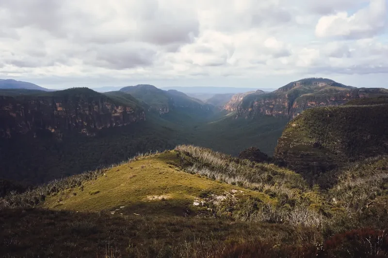
The geological story of the walk is written in the Hawkesbury Sandstone and Narrabeen Group rocks that form the massive cliffs and overhangs. These natural shelters have provided refuge for Aboriginal people for millennia, and the walk passes several sites of immense cultural significance, including grinding grooves and potential rock art sites. The water is a constant companion; the trail follows the meandering path of the Sassafras Creek, which has carved its way through the soft stone over millions of years, creating a series of pools and small cascades that offer a serene soundtrack to the hike.
Wildlife is abundant for those who walk quietly. The Blue Mountains are a stronghold for the superb lyrebird, whose complex songs can be heard echoing through the gullies. You may also encounter brush turkeys, king parrots, and, if you are lucky, the elusive platypus in the quieter reaches of the creek. The walk is designed to be a "slow" experience, encouraging walkers to engage their senses—feeling the texture of the bark, smelling the damp earth of the rainforest, and understanding the seasonal changes that dictate life in the bush. It is a masterclass in Australian biodiversity, contained within a manageable day trip from the nation's largest city.
History and Cultural Context
The history of the Blue Mountains Walkabout is inextricably linked to the Darug and Gundungurra people, the traditional custodians of this land. For tens of thousands of years, these ridges and gullies served as vital corridors for travel, trade, and ceremony. The "Walkabout" itself is a term often misunderstood by non-Indigenous people; in this context, it refers to a ritual journey of transition and a way of maintaining the spiritual connection to "Country." The area around Faulconbridge contains numerous archaeological sites, including rock shelters and axe-grinding grooves, which serve as a permanent record of the long-standing Aboriginal presence.
European history in the area began in the early 19th century as explorers sought a way across the seemingly impassable sandstone ramparts to the fertile plains of the west. Faulconbridge was named after the maiden name of the mother of Sir Henry Parkes, the "Father of Federation," who had a home in the area. The tracks used today, such as the Victory Track, were largely formalised in the late 19th and early 20th centuries as the Blue Mountains became a popular retreat for Sydneysiders seeking the "bracing mountain air." The Victory Track was specifically named to commemorate the end of World War I, reflecting the era's penchant for naming natural landmarks after significant national events.
Today, the Blue Mountains Walkabout represents a modern effort to integrate these two histories. By walking the trail with an awareness of its Aboriginal heritage, visitors participate in a process of reconciliation and education. The land is managed with a focus on preserving both its natural beauty and its cultural integrity, ensuring that the stories of the Darug and Gundungurra people continue to be told alongside the tales of European exploration and settlement.
Want more background? Read extended notes on history and cultural context → Learn more
Seasonal Highlights and Weather Reality
The Blue Mountains experience a temperate climate, but the elevation means it is consistently cooler and wetter than the Sydney basin. Understanding the seasonal nuances is essential for a safe and enjoyable walk.
Spring (September–November): This is arguably the best time for the Walkabout. The bush comes alive with wildflowers, including the iconic Waratah, various species of Grevillea, and the delicate fringe lily. The birdlife is most active during this period, and the temperatures are mild, typically ranging from 10°C to 22°C. The waterfalls are usually flowing well after the winter rains.
Summer (December–February): Summer can be challenging due to the heat. While the rainforest gullies remain significantly cooler than the ridges, temperatures on the exposed sections can exceed 30°C. This is also the peak season for afternoon thunderstorms, which can cause rapid rises in creek levels. Walkers must be mindful of bushfire risk during this season; always check the Rural Fire Service (RFS) website for "Total Fire Ban" declarations and track closures.
Autumn (March–May): Similar to spring, autumn offers stable weather and pleasant temperatures. The light in the gullies is particularly beautiful as the sun sits lower in the sky, illuminating the moss-covered rocks and ferns. The humidity of summer begins to drop, making the steep climbs more comfortable.
Winter (June–August): Winter in the mountains is crisp and clear. Daytime temperatures often hover between 5°C and 15°C, but it can drop below freezing overnight. While the rainforest remains evergreen, the air is much drier. This is a great time for walking if you enjoy the cold, but you must be prepared with layers, as the shade of the gullies can feel icy even on a sunny day.
Recommended Itinerary
Blue Mountains Walkabout Day Itinerary
Early Morning: Arrival and The Ridge Descent
- 09:00: Arrive at Faulconbridge Railway Station.
- 09:15: Begin the walk from the trailhead located on the northern side of the station.
- 09:30: Enter the dry sclerophyll forest. Observe the "scribbly gums" (Eucalyptus rossii) and look for the distinctive markings left by moth larvae.
- 10:00: Begin the descent into Sassafras Gully via the Victory Track. The path drops steeply through sandstone layers.
- 10:30: Reach the first major sandstone overhang. This is an ideal spot for a short break to observe the transition in vegetation.
Midday: The Rainforest and Creek Walk
- 11:00: Arrive at the floor of Sassafras Gully. The environment shifts to a lush rainforest.
- 11:30: Follow the Sassafras Creek downstream. The track is often damp and can be slippery.
- 12:00: Reach a suitable clearing or a flat sandstone rock by the creek for lunch. Listen for the call of the Eastern Whipbird.
- 12:45: Continue along the creek, passing through groves of giant tree ferns (Cyathea australis).
- 13:30: Arrive at the junction with the Magdala Creek track. This area often features beautiful reflections in the still pools of the creek.
Afternoon: The Ascent and Return
- 14:00: Begin the steady climb back towards the ridge. The ascent is gradual but persistent.
- 14:45: Pass through "The Grotto," a small, shaded side-canyon with delicate mosses and ferns.
- 15:30: Re-emerge onto the ridge top. The vegetation returns to the hardier banksia and hakea species.
- 16:00: Return to Faulconbridge Railway Station.
- 16:15: Optional visit to a local café in Faulconbridge or Springwood for a post-walk refreshment.
Important Notes:
- The track can be muddy after rain; waterproof footwear is highly recommended.
- Mobile reception is patchy in the deep gullies.
- There are no water refill stations on the trail; carry at least 2 litres.
- The walk involves several creek crossings which may require stepping on stones; trekking poles can be helpful for balance.
Planning and Bookings
Book Your Trip
Everything you need to plan your journey
Accommodation
Find places to stay near Sydney
Flights
Search flights to Sydney
Essential Preparation
The Blue Mountains Walkabout is a moderate hike that requires a reasonable level of fitness. While the total elevation gain is only 120 metres, the terrain is uneven, with many stone steps and potentially slippery creek crossings. Walkers should be comfortable with steep descents and sustained uphill sections. No formal bookings are required for the trail itself as it is part of the public track system within the Blue Mountains National Park and local council reserves.
Logistically, the walk is best accessed via the Blue Mountains Train Line from Sydney's Central Station. The journey takes approximately 1 hour and 30 minutes. If driving, there is limited parking available at Faulconbridge Station. It is highly recommended to check the NSW National Parks and Wildlife Service (NPWS) website for any "Alerts" regarding track closures due to maintenance, landslides, or fire risk before departing Sydney.
Trail Accommodation
This is a day hike requiring no overnight accommodation. The trail is designed to be completed within a single day, and camping is not permitted within the Sassafras Gully or along the Victory Track. For those wishing to stay in the area, the nearby towns of Springwood, Faulconbridge, and Wentworth Falls offer a variety of accommodation options, including boutique B&Bs, motels, and local guesthouses. Staying overnight in the mountains allows for an early start, which is particularly beneficial during the hotter summer months.
Required Gear
- Footwear: Sturdy hiking boots or trail shoes with good grip. The rainforest sections are often damp and mossy.
- Clothing: Moisture-wicking base layers. Even in summer, a lightweight long-sleeved shirt is recommended for protection against sun and leeches.
- Insulation: A fleece or lightweight down jacket, especially if walking in Autumn or Winter.
- Rain Gear: A breathable waterproof jacket. The Blue Mountains are prone to sudden mist and drizzle.
- Navigation: A physical map or a downloaded offline map (e.g., AllTrails or Gaia GPS). Do not rely on live streaming data in the gullies.
- Backpack: A 15–25 litre daypack with a rain cover.
- First Aid: A basic kit including bandaids, antiseptic wipes, and a compression bandage (essential for snake bite protocol in Australia).
What to Bring
- Water: Minimum 2 litres per person. The creek water is not safe to drink without high-level filtration due to urban runoff from the ridges.
- Food: High-energy snacks (nuts, dried fruit) and a substantial lunch. There are no food outlets on the trail.
- Sun Protection: SPF 50+ sunscreen, a wide-brimmed hat, and sunglasses. The Australian sun is intense, even on cloudy days.
- Insect Repellent: To guard against mosquitoes and leeches, particularly after rain.
- Personal Items: Tissues, hand sanitiser, and a small bag for carrying out all rubbish.
- Emergency: A fully charged mobile phone and a portable power bank. For solo walkers, a Personal Locator Beacon (PLB) is a wise precaution.
Permits
Currently, no permits are required for individual walkers or small private groups to access the Blue Mountains Walkabout via the Faulconbridge tracks. There are no entry fees for this specific section of the Blue Mountains National Park, as the trailhead is located outside the "pay-per-vehicle" zones like those found at Glenbrook.
Commercial and Large Groups:
- Commercial tour operators must hold a valid Parks Eco Pass issued by the NSW National Parks and Wildlife Service.
- Organised groups of more than 20 people should notify the local NPWS office in Blackheath to ensure there are no conflicts with track maintenance or other large events.
- If you are participating in a specific "Aboriginal Cultural Walkabout" program, fees will apply to the tour operator, which covers the cost of the guide and supports local Indigenous community initiatives.
Regulations:
- Domestic animals (dogs, cats) are strictly prohibited on the trail to protect native wildlife.
- Drones are not permitted within the National Park without a specific permit, which is rarely granted for recreational use.
- Smoking is prohibited in all NSW National Parks to reduce fire risk and litter.
Other Activities in the Area
The Blue Mountains offer a wealth of experiences beyond the Faulconbridge area. Consider these nearby attractions to round out your visit:
- Norman Lindsay Gallery and Museum: Located in Faulconbridge, this was the home of the famous Australian artist and writer. The beautiful gardens feature his sculptures, and the gallery houses an extensive collection of his work.
- Wentworth Falls: A 15-minute drive or train ride west, offering some of the most spectacular cliff-edge walks and waterfall views in the region.
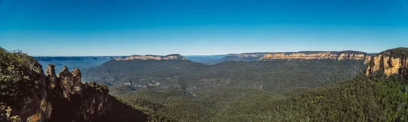
- Echo Point and The Three Sisters: The iconic tourist hub in Katoomba. While busy, the view of the Jamison Valley is world-class.
- Scenic World: Also in Katoomba, featuring the world's steepest passenger railway, a glass-bottomed skyway, and a cableway over the valley.
- Blue Mountains Cultural Centre: Located in Katoomba, this centre features excellent exhibitions on the natural and social history of the mountains.
- Antique Shopping in Leura: The picturesque village of Leura is famous for its gardens, boutiques, and antique stores.
Safety and Conditions
Environmental Hazards:
- Flash Flooding: Sassafras Gully is a drainage point for the surrounding ridges. During and after heavy rain, the creek can rise rapidly. Never attempt to cross a swollen creek. If the water is brown and moving fast, stay on high ground.
- Bushfires: The Blue Mountains are one of the most fire-prone regions in the world. During the summer months, always check the Fire Danger Rating. On days of "Extreme" or "Catastrophic" rating, the park will be closed, and you should not enter the bush.
- Extreme Heat: Heat exhaustion is a genuine risk. Start your walk early, drink plenty of water, and know the signs of heatstroke (dizziness, nausea, cessation of sweating).
Wildlife Safety:
- Snakes: While snakes generally avoid humans, you may encounter Red-bellied Black Snakes or Brown Snakes sunning themselves on the track. Give them a wide berth and never attempt to touch or move them. Wear long trousers and sturdy boots to minimise risk.
- Leeches: Common in the damp rainforest sections, especially after rain. While harmless, they can be unpleasant. Use tropical-strength repellent on your shoes and socks.
- Ticks: Check your body thoroughly after the walk, as paralysis ticks are present in the region.
Navigation and Communication:
- Always tell someone your intended route and expected return time.
- The track is generally well-marked, but leaf litter and fallen trees can sometimes obscure the path. If you lose the trail, backtrack to the last known marker.
- Download the "Emergency Plus" app, which uses your phone's GPS to provide your exact location to emergency services.
Side Trips and Points of Interest
Victory Falls: A short detour from the main Victory Track leads to these beautiful falls. While not the largest in the mountains, the setting is incredibly peaceful, surrounded by mossy rocks and ferns. It is a perfect spot for photography, especially with a long exposure to capture the "silky" water effect.
Clarinda Falls: Located further along the Sassafras Gully track, Clarinda Falls is a delicate cascade that drops into a clear pool. It is often less visited than Victory Falls, offering a greater sense of solitude.
The Elephant Eye: A large, distinctive sandstone overhang that resembles the eye of an elephant. This site has significant cultural resonance and provides a natural shelter that has likely been used for thousands of years. It is a powerful place to sit and reflect on the scale of geological time.
Aboriginal Grinding Grooves: Located on flat sandstone platforms near water sources, these grooves were created by Aboriginal people sharpening stone axe heads. They are a tangible link to the daily lives of the Darug and Gundungurra people and should be viewed with the utmost respect. Never walk on or touch the grooves.
Leave No Trace
The Greater Blue Mountains World Heritage Area is a fragile ecosystem under constant pressure from urban encroachment and high visitor numbers. Practising Leave No Trace principles is essential to ensure the "Walkabout" remains a pristine experience for those who follow.
The Seven Principles in the Blue Mountains:
- Plan Ahead and Prepare: Know the weather, the track conditions, and your own limits.
- Travel on Durable Surfaces: Stay on the marked tracks. Cutting corners causes erosion and destroys delicate ground-cover plants and fungi.
- Dispose of Waste Properly: "Pack it in, pack it out." This includes organic waste like orange peels and apple cores, which do not belong in this ecosystem and can harm native wildlife.
- Leave What You Find: Do not pick wildflowers, remove rocks, or disturb cultural sites. Take only photos, leave only footprints.
- Minimise Campfire Impacts: Fires are strictly prohibited on this trail. Use a lightweight stove if you need to heat food (though not necessary for this day walk).
- Respect Wildlife: Observe animals from a distance. Never feed birds or mammals, as this disrupts their natural diet and can make them aggressive or dependent on humans.
- Be Considerate of Your Hosts and Other Visitors: The Blue Mountains are a place of spiritual significance. Keep noise levels low and yield to other walkers on narrow sections of the track.