The Black Forest Trail - A Journey Through Germany's Emerald Heart
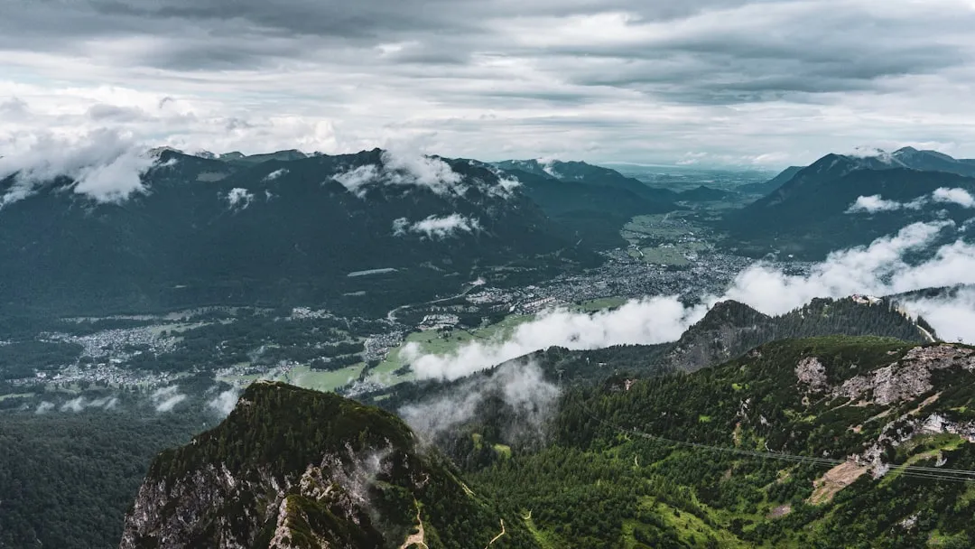
The Black Forest Trail is a premier long-distance trekking experience in southwestern Germany, spanning 285.0 kilometres of dense evergreen canopies, rolling mist-shrouded highlands, and deep glacial valleys. This challenging 9-to-12-day journey traverses the heart of the Baden-Württemberg region, beginning in the high-altitude village of Hinterzarten and weaving through a landscape that has inspired centuries of folklore, from the Brothers Grimm to the intricate craftsmanship of the world-famous cuckoo clock. With a total elevation gain of 8,400 metres, the trail demands physical resilience and careful pacing, rewarding walkers with panoramic views across the Rhine Rift Valley to the French Vosges mountains and the distant Swiss Alps. Unlike many wilderness treks, the Black Forest Trail seamlessly blends raw natural beauty with deep cultural immersion, passing through historic timber-framed villages, high-altitude moors known as "Grinden," and ancient monasteries that have stood for a millennium. This is more than a hike; it is a pilgrimage through the soul of the German wilderness, where the scent of pine needles and the sound of rushing mountain streams create a sensory experience unlike any other in Europe.
- Distance: 285.0 km point-to-point
- Duration: 9–12 days
- Season: May to October (best for hiking; winter requires snowshoes or skis)
- Accommodation: Mountain huts, traditional guesthouses, and forest hotels
- Highest point: Feldberg Summit (1,493 m)
- Total Elevation Gain: 8,400 m
- Difficulty: Challenging (requires high fitness and multi-day experience)
- Closest City: Freiburg im Breisgau
Overview
The Black Forest (Schwarzwald) is perhaps Germany's most iconic natural landscape, a vast mountainous massif that rises sharply from the Rhine Valley. The Black Forest Trail is designed to showcase the sheer diversity of this region, moving from the "High Black Forest" (Hochschwarzwald) in the south to the central ridges. The name "Black Forest" originates from the Romans, who dubbed the region Silva Nigra because the dense growth of conifers—primarily Norway spruce and silver fir—blocked out much of the light on the forest floor, creating a dark, mysterious atmosphere that persists today.
The route is a masterclass in topographical variety. Walkers begin in the southern highlands, where the terrain is defined by glacial activity. Here, you will encounter the Feldberg, the highest peak in Germany outside the Alps, and the Titisee and Schluchsee, pristine lakes carved by ancient ice. As the trail progresses, the landscape shifts into the "Grinden"—unique, treeless high-altitude moors created by centuries of traditional grazing and harsh weather. These plateaus offer 360-degree views that are often compared to the Scottish Highlands, providing a stark contrast to the enclosed, cathedral-like atmosphere of the lower forests.
Geologically, the trail sits on a foundation of crystalline basement rock—gneiss and granite—which has been weathered over millions of years into rounded summits and steep-sided valleys. This geology dictates the flora; the acidic soil supports vast carpets of blueberries, ferns, and mosses that glow with an almost neon intensity after a summer rain. The trail is also a journey through water; the Black Forest is the source of the Danube and numerous other rivers. You will cross countless crystal-clear streams and pass through deep gorges, such as the Wutach Gorge, where the power of erosion is visible in every limestone cliff and waterfall.
What sets the Black Forest Trail apart is the "Vesper" culture. In Germany, hiking is inextricably linked to gastronomy. Every few hours, the trail typically passes a Wanderheim (hikers' hut) or a mountain inn where you can sample Black Forest ham, locally produced cheeses, and the legendary Black Forest cherry gateau (Schwarzwälder Kirschtorte). This blend of strenuous physical exertion and high-quality regional hospitality makes the 285-kilometre journey a civilised yet demanding adventure.
History and Cultural Context
The history of the Black Forest Trail is a tapestry of Roman conquest, medieval monasticism, and the birth of modern hiking culture. For centuries, the forest was a formidable barrier, inhabited only by charcoal burners, glassblowers, and timber rafters who used the region's rivers to transport massive logs as far as the shipyards of the Netherlands. The "Holzknechte" (woodcutters) developed the first rudimentary paths through the dense undergrowth, many of which form the basis of the trail today.
In the 19th century, the Black Forest became the cradle of the German hiking movement. In 1864, the Schwarzwaldverein (Black Forest Association) was founded in Freiburg, making it the oldest hiking club in Germany. This organisation was responsible for the first systematic marking of trails, including the famous Westweg, which shares sections with the Black Forest Trail. The iconic red diamond marker became a symbol of freedom and nature-connection for the growing urban middle class of the Industrial Revolution.
Culturally, the trail passes through regions where traditions are fiercely preserved. In the Gutach Valley and surrounding areas, you may still see women wearing the Bollenhut—a traditional hat topped with large red woollen pom-poms (signifying they are unmarried) or black ones (signifying they are married). The architecture along the route is equally distinctive; the "Schwarzwaldhaus" (Black Forest house) features a massive, low-slung hipped roof designed to shed the heavy winter snows and protect the livestock housed on the ground floor. These houses are living museums of a time when the forest was a place of both survival and spiritual mystery.
Want more background? Read extended notes on history and cultural context → Learn more
Seasonal Highlights and Weather Reality
The Black Forest Trail is most accessible from May to October, but each month within this window offers a distinct character. Spring (May and June) is a period of vibrant awakening. The meadows are filled with wildflowers, and the streams are at their most powerful due to snowmelt from the higher peaks. However, late-season snow can still linger on the Feldberg until mid-May, requiring caution.
Summer (July and August) provides the most stable weather, with temperatures in the valleys reaching 25–30°C. The dense forest canopy offers a natural air-conditioning, keeping the trail significantly cooler than the surrounding Rhine plain. This is the peak season for the high-altitude moors, where the heather begins to bloom. Afternoon thunderstorms are common in the mountains; they arrive quickly and can be intense, so early starts are recommended.
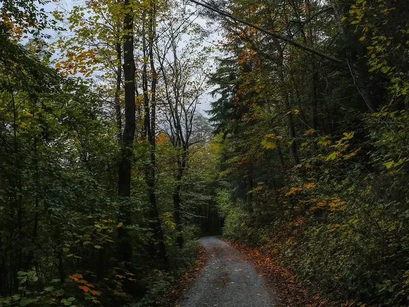
Autumn (September and October) is arguably the most beautiful time to walk. The beech and maple trees turn brilliant shades of gold and orange, contrasting with the dark green of the firs. The air is crisp and clear, often providing the best visibility for views of the Alps. This is also the season of the wine harvest in the nearby foothills, and many mountain huts serve "Neuer Süßer" (partially fermented grape juice) and onion tart.
Winter (November to April) transforms the trail into a serious alpine environment. The Black Forest receives significant snowfall, and the trail is not maintained for walking during this time. Many sections become part of a vast network of cross-country ski trails (Loipen) or snowshoe routes. Attempting the full 285-kilometre trek in winter requires advanced winter navigation skills, specialised equipment, and a high tolerance for sub-zero temperatures.
Recommended Itinerary
12-Day Black Forest Trail Itinerary
Day 1: Hinterzarten to Feldberg Summit
- Distance: 18 km
- Elevation gain: 750 m
- Time: 5–6 hours
- Start in the picturesque village of Hinterzarten
- Climb through the Emil-Thoma-Weg towards the Feldsee, a dark glacial tarn
- Steep ascent to the summit of Feldberg (1,493 m), the highest point of the trail
- Stay at a mountain lodge near the summit for sunset views
Day 2: Feldberg to Sankt Blasien
- Distance: 24 km
- Elevation gain: 400 m
- Time: 6–7 hours
- Descend from the high peaks into the Menzenschwander Valley
- Pass through alpine meadows and past traditional stone walls
- Arrive in Sankt Blasien, home to a magnificent cathedral with one of the largest domes in Europe
Day 3: Sankt Blasien to Bernau
- Distance: 20 km
- Elevation gain: 600 m
- Time: 5–6 hours
- Ascend the Albsteig ridge for views over the southern massif
- Enter the Bernau high valley, often cited as the most beautiful valley in the Black Forest
- Explore the local wood-carving heritage in the village
Day 4: Bernau to Todtmoos
- Distance: 22 km
- Elevation gain: 550 m
- Time: 6 hours
- Cross the Herzogenhorn ridge, the second-highest peak in the region
- Descend through ancient spruce forests into the pilgrimage town of Todtmoos
- Visit the baroque church in the town centre
Day 5: Todtmoos to Wehr
- Distance: 28 km
- Elevation gain: 450 m
- Time: 8 hours
- Follow the Wehra Gorge, a dramatic and rugged section of the trail
- The path clings to the side of the gorge with steep drops to the river below
- Arrive in the industrial-historic town of Wehr
Day 6: Wehr to Schopfheim
- Distance: 25 km
- Elevation gain: 700 m
- Time: 7 hours
- Climb out of the valley towards the Dinkelberg plateau
- Pass through orchards and vineyards as the landscape softens
- Arrive in the historic market town of Schopfheim
Day 7: Schopfheim to Kandern
- Distance: 26 km
- Elevation gain: 650 m
- Time: 7–8 hours
- Traverse the Hohe Flum, offering views into Switzerland
- Enter the "Markgräflerland" wine region
- Finish in Kandern, a town famous for its pottery and historic steam railway
Day 8: Kandern to Badenweiler
- Distance: 28 km
- Elevation gain: 800 m
- Time: 8–9 hours
- A long day through the foothills of the southern Black Forest
- Pass the ruins of Sausenburg Castle
- Arrive in the spa town of Badenweiler, home to Roman bath ruins
Day 9: Badenweiler to Belchen
- Distance: 24 km
- Elevation gain: 1,100 m
- Time: 7–8 hours
- A significant climb back into the high mountains
- Ascend the Belchen (1,414 m), considered the most beautiful mountain in the forest
- Stay at the Belchenhaus, the highest inn in Baden-Württemberg
Day 10: Belchen to Wiedener Eck
- Distance: 22 km
- Elevation gain: 600 m
- Time: 6 hours
- Follow the ridge line with constant views of the Rhine Valley
- Pass through the historic mining region of Münstertal
- Arrive at the mountain pass of Wiedener Eck
Day 11: Wiedener Eck to Schauinsland
- Distance: 25 km
- Elevation gain: 850 m
- Time: 7–8 hours
- Climb towards the Schauinsland mountain (1,284 m)
- Pass the "Windbuchen"—ancient beech trees shaped by centuries of westerly winds
- Views of Freiburg and the Kaiserstuhl volcano in the distance
Day 12: Schauinsland to Freiburg
- Distance: 23 km
- Elevation gain: 300 m (mostly descent)
- Time: 6 hours
- A long, scenic descent from the mountains into the city
- Pass through the Kybfelsen forest
- Finish at the Freiburg Minster (Münster) in the heart of the old town
Planning and Bookings
Book Your Trip
Everything you need to plan your journey
Accommodation
Find places to stay near Freiburg
Flights
Search flights to Freiburg
Essential Preparation
The Black Forest Trail requires a high level of physical fitness due to the cumulative elevation gain of 8,400 metres. Walkers should be comfortable with back-to-back days of 20–28 kilometres. Training with a weighted pack on hilly terrain is essential. Logistics are simplified by the excellent German rail network (Deutsche Bahn). Freiburg is the primary gateway; from here, regional trains run frequently to the trailhead in Hinterzarten (approx. 30 minutes).
A unique feature of planning in this region is the KONUS Guest Card. If you stay overnight in participating hotels or guesthouses, you receive this card for free, which allows for unlimited free travel on all regional buses and trains throughout the Black Forest. This is invaluable for skipping sections or returning to a base town if weather turns foul.
Trail Accommodation
Accommodation on the Black Forest Trail is varied and generally of a high standard. Unlike the remote huts of the Alps, most stops are in or near villages, though several high-altitude mountain inns exist.
Types of Accommodation:
- Wanderheime: Dedicated hikers' huts managed by the Schwarzwaldverein. These offer basic, clean dormitory-style rooms or small private rooms. They are affordable and social.
- Gasthöfe (Guesthouses): Traditional family-run inns. These provide private rooms with en-suite bathrooms and usually include a substantial breakfast.
- Berghotels: High-altitude hotels (like the Belchenhaus or Feldberger Hof). These offer spectacular views but are more expensive and require booking months in advance.
- Campsites: Wild camping is strictly prohibited in the Black Forest. You must stay at designated campsites, which are relatively rare on the high ridges but common in the valleys.
Facilities and Costs: Most accommodation provides bedding and towels (except for some basic Wanderheime where a silk liner is required). Half-pension (dinner and breakfast) is commonly available and recommended. Expect to pay €35–€50 for a hut bunk and €70–€120 for a double room in a guesthouse. Booking is essential during July, August, and September.
Required Gear
- Footwear: Sturdy, waterproof trekking boots with good ankle support. The terrain is often rocky or muddy.
- Rain Gear: A high-quality waterproof jacket and overtrousers. The Black Forest is one of Germany's wettest regions.
- Backpack: A 35–50L pack with a proper suspension system and rain cover.
- Navigation: A physical 1:25,000 scale map and a GPS device or offline smartphone app (e.g., Komoot or Outdooractive). While the trail is well-marked with diamonds, mist can make navigation difficult on the plateaus.
- Clothing: Moisture-wicking base layers, a fleece or down mid-layer (even in summer, temperatures on the Feldberg can drop to 5°C), and quick-drying trekking trousers.
- First Aid: Including blister plasters (Compeed), antiseptic, and a tick removal tool.
What to Bring
- Water Treatment: While tap water in Germany is excellent, stream water should be treated due to livestock grazing in the high meadows. Bring a lightweight filter or tablets.
- Sun Protection: SPF 50+ sunscreen, sunglasses, and a wide-brimmed hat. The sun on the treeless "Grinden" is intense.
- Snacks: High-energy food like nuts, dried fruit, and chocolate. While inns are frequent, some sections have 4–5 hours between facilities.
- Cash: Many smaller mountain huts and rural guesthouses do not accept credit cards. Carry at least €200–€300 in cash for emergencies and small purchases.
- Power Bank: To keep navigation devices charged, as some older huts have limited power outlets.
- Toiletries: Biodegradable soap and a quick-dry travel towel.
Permits
No formal permits are required to walk the Black Forest Trail. The path is open to the public year-round. However, because wild camping is illegal, your "permit" to be on the trail overnight is effectively your accommodation booking. In the Southern Black Forest Nature Park (Naturpark Südschwarzwald), rangers strictly enforce the no-camping rule to protect the habitat of the endangered Capercaillie (Auerhuhn).
Booking Strategy:
- For the high season (July–September), book your accommodation at least 3–4 months in advance.
- If staying in Wanderheime, check the opening days; some are closed on Mondays or Tuesdays (Ruhetag).
- Use the official Black Forest Tourism website to find certified "Wanderfreundliche" (hiker-friendly) hosts who offer luggage transfer services between stages.
Luggage Transfer: For those who prefer to walk with only a daypack, several local companies offer "Wandern ohne Gepäck" (hiking without luggage) packages. They will transport your main suitcase from one hotel to the next for a fee of approximately €15–€20 per day.
Other Activities in the Area
The Black Forest offers a wealth of experiences beyond the main trail:
- Freiburg im Breisgau: Spend a day in Germany's "sunniest city." Explore the medieval old town, walk along the "Bächle" (small water-filled runnels in the streets), and climb the Minster tower for views of the forest you just traversed.
- Thermal Baths: Visit the Cassiopeia Therme in Badenweiler or the Steinmarne in Freiburg to soothe aching muscles in mineral-rich volcanic waters.
- Cuckoo Clock Workshops: In the Triberg or Schonach area, you can visit master craftsmen who still hand-carve these iconic timepieces.
- Titisee Boat Trips: Take a solar-powered boat across the Titisee or rent a rowboat to see the mountains from the water.
- Vogtsbauernhof Open Air Museum: Located in Gutach, this museum features original Black Forest farmhouses from the 16th century, moved piece-by-piece to the site.
- Schluchsee Sailing: The largest lake in the region is a hub for sailing and windsurfing in the summer months.
Safety and Conditions
Weather Hazards: The primary safety concern on the Black Forest Trail is the rapid change in weather. The mountains act as a barrier for weather systems moving in from the Atlantic. Sudden fog can reduce visibility to less than 10 metres on the Feldberg and Belchen plateaus, making it easy to lose the trail markers. If fog rolls in, stay on the marked path and use your GPS. Thunderstorms in summer are frequent; if you hear thunder, descend from the ridges immediately. Do not seek shelter under isolated trees.
Wildlife and Health: The Black Forest is a high-risk area for Ticks (Zecken), which can carry Lyme Disease and FSME (Tick-borne encephalitis). Wear long trousers in tall grass, use repellent, and perform a thorough tick check every evening. There are no dangerous large predators; the Eurasian Lynx is present but extremely elusive and poses no threat to humans. Wild boar are common but will generally avoid hikers unless they feel cornered or have young.
Terrain: While not technically "alpine" in the sense of requiring climbing, the trail has many sections with loose scree, slippery roots, and steep gradients. The Wutach Gorge section can be particularly slippery after rain. Trekking poles are highly recommended to reduce the strain on knees during the 8,400 metres of descent.
Emergency Services: The universal emergency number in Germany is 112. Mobile signal is generally good on the ridges but can be non-existent in the deep valleys and gorges. Carry a whistle and a basic emergency bivvy bag.
Side Trips and Points of Interest
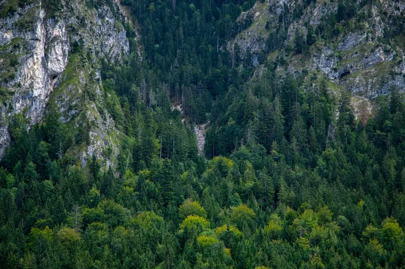
The Wutach Gorge (Wutachschlucht): Often called the "Grand Canyon of the Black Forest," this is a spectacular side trip or alternative section. The river has carved a deep limestone canyon filled with rare flora and over 500 species of butterflies. The path is narrow and rugged, passing beneath towering cliffs and through lush, jungle-like vegetation.
Triberg Waterfalls: One of Germany's highest waterfalls, plunging 163 metres over seven cascades. While touristy, the falls are spectacular, especially after heavy rain or during the spring melt. The surrounding forest is home to very friendly red squirrels that are accustomed to hikers.
The Ravenna Gorge (Ravennaschlucht): Located near Hinterzarten, this short, steep gorge features a stunning 36-metre-high stone railway viaduct. The trail through the gorge passes several historic mills and small waterfalls, offering a perfect "warm-up" for the main trail.
The Belchen Summit: While part of the main itinerary, it deserves special mention. On a clear day, the Belchen offers the most famous view in the Black Forest, stretching from the Zugspitze in the east to Mont Blanc in the south-west. It is a site of ancient Celtic significance, believed to be part of a "Belchen System" used for solar observations.
Leave No Trace
The Black Forest is a managed landscape but contains highly sensitive ecological zones. The "Waldknigge" (Forest Etiquette) is a set of informal rules that all hikers are expected to follow to preserve the "Green Heart" of Germany.
Core Principles:
- No Wild Camping: This is the most important rule. Use designated huts and guesthouses to prevent soil compaction and disturbance to wildlife.
- Stay on Marked Paths: The forest is home to the Capercaillie, a large forest grouse that is extremely sensitive to human disturbance. Leaving the path, especially in winter or spring, can lead to the death of these birds due to stress.
- Waste Management: Pack out all rubbish, including organic waste like banana skins or apple cores, which do not decompose quickly in the acidic forest soil and can harm local wildlife.
- Noise Control: Keep noise to a minimum, especially at dawn and dusk when animals are most active.
- Fire Safety: Open fires are strictly prohibited. The forest floor is often covered in a thick layer of dry pine needles that are highly flammable.
- Water Protection: Do not use soaps or detergents in the mountain streams. Even biodegradable soaps can disrupt the delicate pH balance of the water.