Big Bend Outer Mountain Loop - The Desert's Ultimate Challenge
The Big Bend Outer Mountain Loop is the definitive wilderness experience of the American Southwest—a 48.3-kilometre circuit that traverses the dramatic verticality of the Chisos Mountains and the unforgiving expanse of the Chihuahuan Desert. Located within Big Bend National Park in Texas, this trail is not merely a walk; it is a high-stakes journey through three distinct ecosystems. From the "Sky Island" of the Chisos, where ponderosa pines and Douglas firs cling to volcanic peaks, the route plunges over 900 metres down to the desert floor, where heat, aridity, and ancient geological formations dominate the landscape. This is a trek that demands meticulous preparation, particularly regarding water logistics, as the environment is as beautiful as it is indifferent to the traveller. For those who successfully navigate its switchbacks and sun-scorched flats, the reward is a profound sense of solitude and a perspective on the natural world that few other trails on the continent can provide.
- Distance: 48.3 km loop
- Duration: 3–4 days
- Season: October–April (extreme heat makes summer travel life-threatening)
- Campsites: Backcountry permits required; designated sites in high country, zone camping in desert
- Highest point: Emory Peak (2,385 m) via optional side trip; trail high point ~2,200 m
- Total Elevation Gain: 1,524 m
- Difficulty: Challenging/Expert (due to navigation, elevation, and water scarcity)
- Direction: Usually hiked clockwise (Pinnacles to Juniper Canyon) or anti-clockwise
Overview
The Outer Mountain Loop (OML) is often described as a "three-day masterclass in desert survival and mountain endurance." It is the most strenuous hike in Big Bend National Park, combining the Pinnacles, Juniper Canyon, Dodson, Blue Creek, and Laguna Meadows trails into one continuous loop. The brilliance of the OML lies in its staggering ecological diversity. In a single day, a hiker can transition from a cool, shaded forest of Mexican drooping juniper and oak to a landscape of prickly pear cactus, ocotillo, and creosote bush where the sun reflects off volcanic rhyolite with intense ferocity.
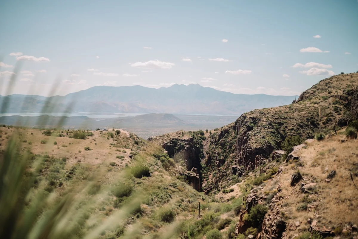
The journey begins in the Chisos Basin, a natural bowl surrounded by jagged peaks that rise like a fortress from the desert floor. The initial ascent is a test of cardiovascular fitness, climbing steeply through the Pinnacles Trail. Once atop the high ridges, the views extend for hundreds of kilometres, reaching deep into the mountains of Coahuila, Mexico. The descent into Juniper Canyon marks the transition from the alpine to the arid. The middle section of the loop, the Dodson Trail, is the psychological and physical crux of the trip. Stretching 18.3 kilometres across the desert floor, it offers no shade and no reliable water, requiring hikers to carry or cache every drop they need. The final leg involves a gruelling 900-metre climb back up the Blue Creek Canyon, where the "Red Rocks" formations provide a surreal, Martian backdrop to the final push back into the Chisos Basin.
This is a landscape defined by its extremes. While the Chisos Mountains can experience sub-zero temperatures and snow in winter, the desert floor just a few kilometres away can swelter in 35°C heat. The OML is a journey of contrasts: the silence of the high ridges versus the rhythmic crunch of gravel in the desert washes; the vibrant green of the mountain flora versus the muted greys and browns of the scrubland. It is a trail that requires respect for the elements and a deep understanding of one's own physical limits. For the prepared adventurer, it is the finest way to experience the raw, unvarnished heart of the Big Bend.
History and Cultural Context
The land encompassed by the Outer Mountain Loop has been a crossroads of human history for over 10,000 years. Long before it was a National Park, the Chisos Mountains served as a sanctuary and a stronghold for various Indigenous groups. The name "Chisos" is thought by some to be derived from a Castilian word for "ghosts" or "spirits," while others link it to the Chizo Indians, a group that inhabited the region before being displaced. Later, the Mescalero Apache and the Comanche utilised these mountains as a refuge and a landmark during their seasonal migrations and raids across the Rio Grande. The hidden springs and high-altitude meadows provided essential resources in an otherwise harsh environment.
In the late 19th and early 20th centuries, the region saw the arrival of European-American settlers, miners, and ranchers. The Outer Mountain Loop passes through the remnants of this era, most notably at the Homer Wilson Ranch (Blue Creek Ranch). Established in the 1920s, this was once one of the largest sheep and goat ranching operations in the state. The historic ranch house, which still stands near the junction of the Blue Creek Trail and the Ross Maxwell Scenic Drive, serves as a poignant reminder of the tenacity required to eke out a living in this rugged terrain. The ranchers faced the same challenges hikers do today: extreme weather and a desperate lack of water.
The transition from private ranchland to a protected wilderness began in the 1930s. During the Great Depression, the Civilian Conservation Corps (CCC) played a pivotal role in developing the park's infrastructure. From 1934 to 1942, young men of the CCC lived in the Chisos Basin, hand-cutting many of the trails that form the Outer Mountain Loop today. Their craftsmanship is evident in the stone culverts, perfectly graded switchbacks, and the very existence of the Pinnacles and Laguna Meadows trails. Big Bend National Park was officially established in 1944, preserving this unique confluence of mountain and desert for future generations. Today, the OML is recognised not just for its natural beauty, but as a cultural landscape that tells the story of human adaptation to one of North America's most demanding environments.
Want more background? Read extended notes on history and cultural context → Learn more
Seasonal Highlights and Weather Reality
Timing is the most critical factor when planning the Outer Mountain Loop. Unlike many mountain treks that are best enjoyed in summer, the OML is a winter and shoulder-season destination. The Chihuahuan Desert is a land of fierce sun and extreme temperature fluctuations, and the lack of shade on the Dodson Trail makes summer hiking a genuine risk to life.
Autumn (October to November): This is arguably the best time to hike the loop. The summer monsoon rains have usually subsided, leaving the desert surprisingly green and the cacti plump. Temperatures begin to drop from their summer peaks, with daytime highs in the desert ranging from 20°C to 28°C, while the mountains remain crisp and cool. The clarity of the air during autumn provides the best long-distance visibility for photography.
Winter (December to February): Winter offers the most stable hiking temperatures, but it requires preparation for cold nights. It is not uncommon for temperatures in the Chisos Basin to drop to -5°C or lower, and snow occasionally blankets the high peaks. However, the desert floor remains pleasant for hiking during the day. The short daylight hours mean hikers must be disciplined with their starts to reach camp before dark. This is the driest season, making water caching even more vital.
Spring (March to April): Spring brings the spectacular desert bloom. If the winter has seen sufficient moisture, the ocotillo erupt in flaming red blossoms, and the yucca send up massive white flower stalks. This is the most popular time for the park, and backcountry permits can be harder to secure. By late April, temperatures on the desert floor begin to climb toward 30°C, marking the end of the safe hiking window for most people.
Summer (May to September): Hiking the Outer Mountain Loop in summer is strongly discouraged by Park Rangers. Temperatures on the Dodson Trail regularly exceed 40°C, and the heat radiating from the volcanic rock can make the "real feel" even higher. Flash floods are also a significant risk during the July and August monsoon season, as dry washes can turn into raging torrents within minutes of a distant thunderstorm.
Recommended Itinerary
3-Day Outer Mountain Loop Itinerary
Day 1: Chisos Basin to Boot Canyon or South Rim
- Distance: 10–12 km
- Elevation gain: 600 m
- Time: 5–6 hours
- Start at the Pinnacles Trailhead in the Chisos Basin
- Steep ascent through the Pinnacles, offering views of "The Window" and Casa Grande
- Optional side trip to Emory Peak (the park's highest point) adds 5 km return
- Enter the high-altitude forest of Boot Canyon, named for a boot-shaped rock spire
- Camp at designated sites in Boot Canyon or along the South Rim
- The South Rim offers a 300-metre vertical drop with views across the Rio Grande into Mexico
- This day is about vertical gain and adjusting to the altitude of the "Sky Island"
Day 2: South Rim to the Dodson Trail (Desert Floor)
- Distance: 15–18 km
- Elevation: 900 m descent, then undulating desert terrain
- Time: 7–9 hours
- Descend the Juniper Canyon Trail, a series of steep switchbacks dropping off the mountain
- Transition from pine forest to desert scrub as the temperature rises
- Reach the junction with the Dodson Trail at the base of the mountains
- Traverse the eastern half of the Dodson Trail, crossing numerous dry washes (arroyos)
- Pass the remains of old line shacks and historic ranching sites
- Camp in a "Zone Camping" area along the Dodson Trail (ensure you are 1 km from any road)
- This is the most exposed section of the trail; sun protection is mandatory
Day 3: Dodson Trail to Chisos Basin via Blue Creek
- Distance: 18–20 km
- Elevation: 900 m gain
- Time: 8–10 hours
- Complete the western half of the Dodson Trail toward the Homer Wilson Ranch
- Retrieve water from your pre-placed cache at the Homer Wilson Ranch cache box
- Begin the long, steady ascent of the Blue Creek Trail
- Pass through the "Red Rocks," a spectacular canyon of towering crimson tuff formations
- The trail steepens significantly in the final 4 km as it climbs back into the Chisos
- Re-enter the forest at Laguna Meadows for a gentle final descent to the Basin
- Finish back at the Chisos Basin trailhead
- This is a high-endurance day requiring a very early start to avoid afternoon heat in the canyon
Important Notes:
- Water caching at Homer Wilson Ranch is essential for most hikers
- Backcountry permits must be obtained in person or via the online reservation system
- Bear canisters or bags are required for food storage in the Chisos Mountains
- The trail is rugged and often overgrown; long trousers are recommended to protect against thorny plants
- Check in with the Chisos Basin Visitor Centre for the latest spring flow reports
Planning and Bookings
Book Your Trip
Everything you need to plan your journey
Accommodation
Find places to stay near Alpine
Flights
Search flights to Alpine
Essential Preparation
The Outer Mountain Loop is a serious undertaking that requires more than just physical fitness; it requires logistical precision. The most critical element of preparation is water management. There are no reliable natural water sources on the desert floor. Hikers must "cache" water at the Homer Wilson Ranch cache box (located at Mile 30 on the Ross Maxwell Scenic Drive) before starting their hike. This involves driving to the ranch, placing your water in the bear-proof metal boxes provided by the NPS, and labelling it with your name and expected arrival date.
Fitness requirements are high. You will be carrying a heavy pack (due to water weight) over significant elevation changes in a dehydrating environment. Base yourself in the town of Alpine or Marathon (approx. 1.5 to 2 hours drive) the night before to ensure an early start at the Visitor Centre. Ensure your vehicle is in good condition, as the park is vast and services are limited.
Trail Accommodation
Accommodation on the Outer Mountain Loop consists entirely of backcountry camping. There are no huts or shelters along the route.
High Country Sites (Chisos Mountains):
- Designated sites in areas like Pinnacles, Toll Mountain, Boot Canyon, and South Rim
- Each site has a flat area for a tent and a bear-proof food locker
- No water or toilets provided; you must pack out all waste
- Booking: Required via Recreation.gov or in person at the Visitor Centre
- Cost: Approximately US$15 per permit (covers up to 15 people)
Desert Zone Camping (Dodson Trail):
- No designated sites; you may camp anywhere as long as you are 1 km from any road and out of sight of the trail
- No facilities of any kind
- Must follow strict Leave No Trace principles for waste disposal
- Requires a "Zone" permit from the NPS
What is NOT provided:
- Water (except for what you cache or carry)
- Toilets (except at the Chisos Basin trailhead)
- Electricity or mobile signal
- Emergency services (rescue can take many hours or days)
Required Gear
- Sturdy hiking boots - Must be well broken-in; the volcanic rock is sharp and abrasive
- Navigation - Topographic map and compass are essential; GPS is a useful backup but signal can be spotty in deep canyons
- Sun protection - Wide-brimmed hat, high-SPF sunscreen, and UV-rated sunglasses
- Backpack - 55–75L capacity to accommodate large water volumes (up to 6–8 litres at a time)
- Food storage - Bear-resistant canister or Ursack (required for Chisos sites)
- First aid kit - Must include tweezers (for cactus spines), blister care, and electrolyte salts
- Emergency whistle and signal mirror
- Lightweight tent or bivy - Must be able to withstand high desert winds
What to Bring
- Water - Minimum 4–6 litres per person per day. Do not rely on springs
- Water treatment - Filter or tablets (only as a backup for the unreliable springs)
- High-calorie food - Salty snacks are essential to replace lost electrolytes
- Clothing layers - Moisture-wicking base layers, a warm fleece or down jacket for mountain nights, and a lightweight windbreaker
- Trowel and waste bags - For proper disposal of human waste in desert zones
- Headlamp - With extra batteries; desert nights are profoundly dark
- Personal items - Biodegradable soap, toothbrush, and a small towel
Permits
A backcountry permit is mandatory for all overnight stays on the Outer Mountain Loop. The National Park Service (NPS) strictly limits the number of hikers to preserve the wilderness character of the trail and to ensure safety. Permits can be obtained through a combination of online reservations and "walk-in" availability.
Booking Strategy:
- Reservations: A portion of the Chisos Mountains campsites can be reserved up to six months in advance via Recreation.gov. These fill up quickly for peak dates in November and March.
- Walk-in Permits: Remaining sites and all desert zone permits are issued in person at the Chisos Basin Visitor Centre or Panther Junction Visitor Centre. These are available up to 24 hours in advance.
- Arrive early: During peak season, a queue often forms at the Visitor Centre before it opens at 8:30 AM.
- Flexibility: Have a backup plan for your camping locations in case your first choice is full.
Permit Costs:
- Backcountry Permit: US$15 per permit (covers the entire trip for the group).
- Park Entrance Fee: US$30 per vehicle (valid for 7 days), separate from the backcountry permit.
Water Caching Logistics:
- You must cache your water at the Homer Wilson Ranch cache box *before* you start your hike.
- Label your containers clearly with your name, permit number, and the date you plan to retrieve them.
- Use sturdy, BPA-free plastic containers. Do not use thin milk jugs, as they are prone to leaking and can be chewed through by rodents.
- Remember to retrieve your empty containers after your hike; leaving them behind is considered littering and is a fineable offence.
Other Activities in the Area
Big Bend is a massive park with diverse attractions beyond the Outer Mountain Loop:
- Santa Elena Canyon: A stunning 450-metre limestone canyon carved by the Rio Grande. You can hike into the canyon or take a guided canoe trip.
- Boquillas Hot Springs: Soak in natural 40°C thermal waters on the banks of the Rio Grande, surrounded by historic ruins and pictographs.
- Ross Maxwell Scenic Drive: A 48-kilometre drive offering some of the best geological views in the park, including Mule Ears Peaks and Tuff Canyon.
- Stargazing: Big Bend is a designated International Dark Sky Park. The lack of light pollution makes it one of the best places in North America to see the Milky Way.
- Boquillas del Carmen: Take a rowboat across the river to visit this small Mexican village for lunch and handicrafts (valid passport required).
- Lost Mine Trail: A shorter (7.7 km) but spectacular hike in the Chisos Mountains for those with extra energy.
Safety and Conditions
Heat and Hydration: The primary danger on the Outer Mountain Loop is heat exhaustion and dehydration. The Chihuahuan Desert is an arid environment where sweat evaporates almost instantly, meaning you may not realise how much fluid you are losing. You must drink even when you are not thirsty. Hyponatremia (low blood sodium) is also a risk; ensure you are consuming salt and electrolytes along with your water.
Wildlife Encounters: Big Bend is home to black bears and mountain lions. While encounters are rare, they are possible, especially in the Chisos Mountains. Store all food, trash, and scented items in the provided bear lockers or an approved bear-resistant container. If you encounter a mountain lion, do not run; stay upright, shout, and throw stones if necessary. Rattlesnakes are also common in the desert; always watch where you step and never put your hands into crevices or under rocks.
Flash Floods: During the rainy season, dry washes can become deadly in seconds. Never camp in a wash or arroyo. If you see dark clouds upstream or hear a distant roar, move to higher ground immediately.
Navigation: The Dodson Trail can be faint in places, especially where it crosses rocky washes. Look for "cairns" (small stacks of rocks) that mark the route. If you lose the trail, do not wander; backtrack to the last known marker and scout from there. Always carry a physical map, as electronic devices can fail in the heat.
Emergency Communication: There is no mobile phone service on most of the loop. A satellite messenger (like a Garmin inReach or Zoleo) is highly recommended for solo hikers or those attempting the loop for the first time.
Side Trips and Points of Interest
Emory Peak: The highest point in Big Bend National Park at 2,385 metres. The trail branches off the Pinnacles Trail and involves a 5-kilometre return trip with a final 10-metre scramble to the summit. The 360-degree views from the top are unparalleled, encompassing the entire park and deep into Mexico. The summit is also home to a collection of radio antennae and a solar-powered monitoring station.
The South Rim: Many hikers consider the South Rim the highlight of the entire park. The trail follows the edge of a massive volcanic escarpment, offering a sheer drop-off with views that stretch for over 150 kilometres. It is a perfect spot for a long lunch or a high-country camp, especially at sunset when the desert floor below turns shades of purple and gold.
Homer Wilson Ranch: This historic site provides a fascinating look at the region's pastoral past. The main house is built of local stone and was designed to stay cool in the desert heat. Exploring the ruins of the corrals and outbuildings gives a sense of the immense scale of the ranching operations that once dominated the Big Bend.
The Red Rocks (Blue Creek Canyon): As you ascend the Blue Creek Trail, you pass through a section of towering, eroded volcanic tuff. These formations are a vibrant rust-red colour and have been sculpted by wind and water into fantastic shapes. The acoustics in this part of the canyon are remarkable, often amplifying the sound of the wind or the calls of canyon wrens.
Leave No Trace
The Big Bend wilderness is a fragile ecosystem where human impact can remain visible for decades. The "Leave No Trace" principles are not just guidelines here; they are essential for the survival of the park's flora and fauna.
Desert-Specific LNT:
- Biological Soil Crusts: Much of the desert floor is covered in a "living skin" of cyanobacteria, lichens, and mosses. This crust prevents erosion and fixes nitrogen in the soil. A single footprint can destroy crust that took 50 years to grow. Always walk on established trails or bare rock.
- Waste Disposal: In the Chisos Mountains, use the provided toilets at the trailhead. In the desert zones, you must bury human waste in a "cathole" 15–20 cm deep and at least 60 metres from any wash or campsite. Better yet, use a "WAG bag" to pack out all human waste.
- Pack It In, Pack It Out: This includes all food scraps (even orange peels and nut shells), which do not decompose quickly in the arid climate and can attract wildlife.
- Water Sources: If you find a rare desert spring or "tinaja" (natural rock pool), do not wash in it or contaminate it. These are vital lifelines for wildlife. Collect water and move at least 60 metres away to filter or use it.
- Respect the Silence: The desert is a place of profound quiet. Avoid loud music or shouting, allowing yourself and others to hear the natural sounds of the wilderness.