The Bicentennial National Trail
The Bicentennial National Trail (BNT) is Australia's longest marked multi-use trail, stretching an astonishing 5,330 kilometres from the coast of Victoria to the tip of Queensland. Conceived to commemorate Australia's bicentenary in 1988, this epic journey traverses a breathtaking diversity of landscapes, from the rolling hills and temperate forests of the Great Dividing Range to the arid outback, tropical rainforests, and coastal plains. It is a true test of endurance, navigation, and self-sufficiency, offering an unparalleled opportunity to experience the vastness and varied beauty of the Australian continent.
- Distance: 5,330 km one-way
- Duration: 6–12 months (depending on mode of travel and pace)
- Season: Varies significantly by section; generally Autumn and Spring offer milder temperatures across most of the trail.
- Difficulty: Challenging (requires significant fitness, navigation skills, and self-sufficiency)
- Closest Major City: Alice Springs (for central sections), Brisbane (for southern sections), Cairns (for northern sections)
- Trailhead Access: Highly variable; access points are numerous and depend on the chosen section. Nearest major airport for central sections is Alice Springs (ASP). Ground transport often requires 4WD vehicles or specialised logistics.
- Elevation Gain: Approximately 60,000 m
- Direction: Primarily north-to-south or south-to-north, but can be traversed in sections.
Overview
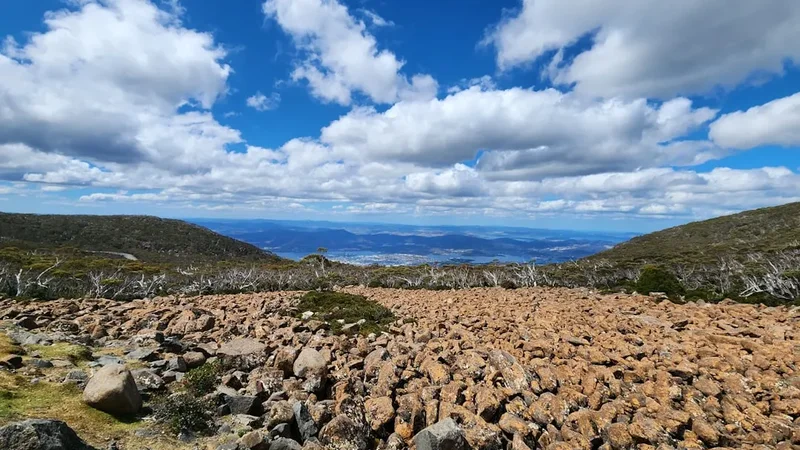
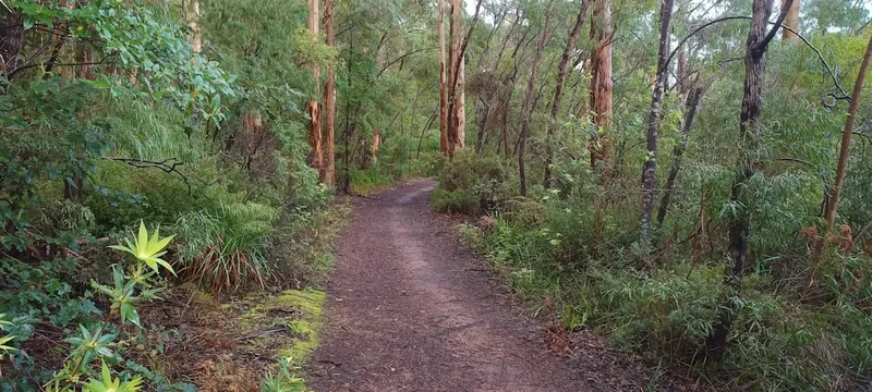
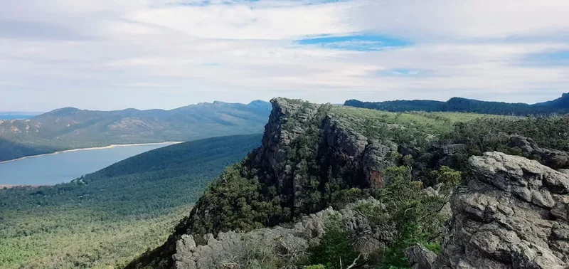
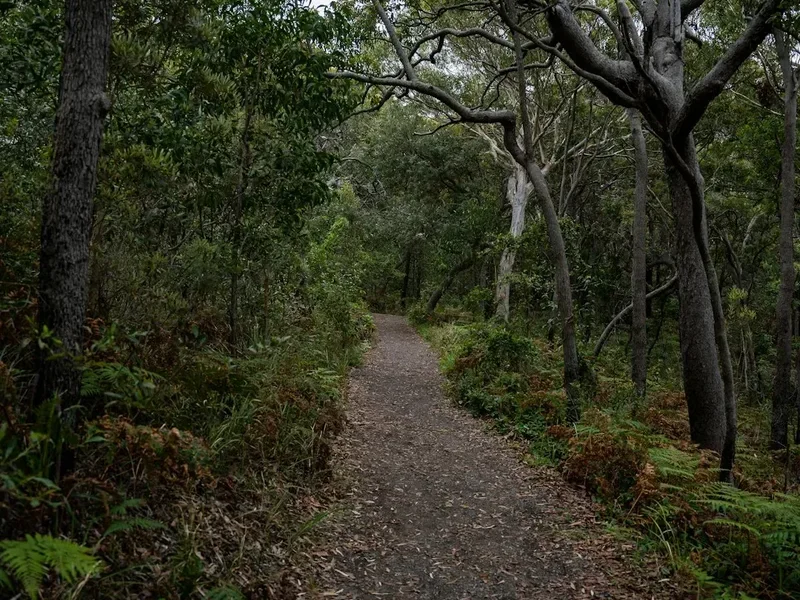
The Bicentennial National Trail is not a single, continuous path but rather a network of existing trails, fire roads, and bush tracks that have been linked together. This intricate web means that the trail's character changes dramatically as you progress through different states and environments. In Victoria and New South Wales, walkers will find themselves immersed in the Great Dividing Range, navigating through eucalyptus forests, past cascading waterfalls, and over rugged mountain passes. The air is often cool and damp, and the scent of eucalyptus is ever-present.
As the trail moves north into Queensland, the landscape transforms. The Great Dividing Range continues, but the vegetation shifts towards drier sclerophyll forests and eventually into the more open woodlands and savannas characteristic of inland Queensland. Sections can become remote, requiring careful planning for water and supplies. The climate becomes warmer, and the challenges of heat and sun become more pronounced.
Further north, the trail may skirt the edges of the Great Barrier Reef's hinterland, offering glimpses of tropical rainforests and a vastly different flora and fauna. The final sections can lead towards the Cape York Peninsula, a region of immense natural beauty and cultural significance, though access to the very northernmost points can be restricted or require specialised permits.
The BNT is a journey of immense personal challenge. It demands not only physical endurance but also mental fortitude to cope with isolation, variable weather conditions, and the logistical complexities of resupply in remote areas. It is a trail for those seeking a profound connection with the Australian landscape, a deep understanding of its natural systems, and a true test of their own capabilities. The rewards are immense: the satisfaction of completing an extraordinary feat, the discovery of hidden natural wonders, and the forging of an intimate relationship with the Australian bush.
History and Cultural Context
The concept of the Bicentennial National Trail (BNT) was born in the lead-up to Australia's Bicentenary in 1988. The idea was to create a long-distance trail that would celebrate the nation's natural heritage and provide a challenging adventure for Australians and international visitors alike. The trail was not a single, newly constructed path but rather a carefully curated and linked series of existing routes, including national park tracks, fire trails, stock routes, and public access roads.
The initial development and marking of the BNT were undertaken by a dedicated team of volunteers, primarily associated with equestrian and bushwalking organisations. Their vision was to connect diverse natural environments across three states, showcasing the varied landscapes of eastern Australia. This monumental task involved extensive reconnaissance, negotiation with landowners and government authorities, and the physical marking of thousands of kilometres of trail.
The BNT's route has evolved since its inception. While the core alignment remains, sections may have been rerouted due to land access changes, environmental concerns, or improved trail management. The trail's multi-use nature means it is shared by walkers, horse riders, and mountain bikers, each group contributing to its vibrant history and ongoing use.
Culturally, the BNT traverses lands that have been home to Indigenous Australians for tens of thousands of years. The trail passes through areas of significant cultural heritage, and walkers are encouraged to be respectful of these ancient connections to the land. The route also follows historical stock routes and exploration paths, offering a tangible link to Australia's pioneering past and the development of its rural industries.
The BNT represents a significant achievement in Australian trail development, a testament to the power of volunteer effort and a commitment to preserving and showcasing the nation's natural beauty. It continues to be a pilgrimage for those seeking an epic adventure and a deep immersion in the Australian wilderness.
Seasonal Highlights and Weather Reality
The Bicentennial National Trail spans a vast geographical area, meaning seasonal considerations are paramount and vary dramatically from south to north. Attempting the entire trail in one continuous journey requires careful timing to avoid extreme weather conditions.
Southern Sections (Victoria, Southern NSW):
- Autumn (March–May): Generally considered the best time. Mild temperatures, clear skies, and beautiful autumn colours in the forests. Lower risk of bushfires.
- Spring (September–November): Pleasant temperatures, wildflowers bloom, and water sources are usually reliable. Can be wet in some areas.
- Summer (December–February): Can be very hot, especially in lower elevations. High risk of bushfires, which can lead to trail closures. Water sources may be scarce.
- Winter (June–August): Cold, especially at higher elevations in the Great Dividing Range. Snow is possible, and some sections may be impassable or require winter-specific gear and skills. Shorter daylight hours.
Central Sections (Northern NSW, Central QLD):
- Autumn (March–May): Ideal. Mild temperatures, reduced humidity, and lower risk of extreme heat.
- Spring (September–November): Warm to hot. Water can become a concern in drier areas.
- Summer (December–February): Very hot and humid, particularly in Queensland. High risk of bushfires and cyclones in coastal areas. Many sections are best avoided during this period.
- Winter (June–August): Mild and pleasant during the day, but can be cool to cold at night. This is often a good time for these sections.
Northern Sections (Northern QLD):
- Dry Season (May–October): The most favourable period. Warm to hot days, cooler nights, and significantly reduced humidity. Lower risk of cyclones and heavy rainfall. Water sources are more reliable.
- Wet Season (November–April): Extremely hot and humid with heavy rainfall, often leading to flash floods and impassable tracks. Cyclones are a significant risk. Many northern sections are inaccessible or dangerous during this time.
General Advice:
- For a full thru-hike, starting in late Autumn in Victoria and progressing northwards is often recommended to align with favourable weather patterns.
- Always check local weather forecasts and fire danger ratings before and during your journey.
- Be prepared for rapid weather changes, especially in mountainous regions.
Recommended Itinerary
Thru-Hiking the Bicentennial National Trail (Conceptual Itinerary)
The BNT is too extensive for a single, prescriptive itinerary. This conceptual outline provides a framework for a south-to-north thru-hike, highlighting key regions and challenges. Actual planning requires detailed section-by-section research.
Phase 1: Southern Highlands (Victoria & Southern NSW)
- Start: Tidal River, Wilsons Promontory National Park, VIC
- Distance: Approx. 800 km
- Duration: 3–5 weeks
- Key Features: Coastal heath, temperate rainforests, rolling hills, Great Dividing Range foothills.
- Challenges: Steep ascents and descents, variable weather, potential for rain and mud.
- Resupply Points: Towns like Foster, Mirboo North, Warragul, Walhalla, Woods Point, Bright, Harrietville, Omeo, Corryong.
Phase 2: High Country and Border Ranges (NSW)
- Distance: Approx. 1,200 km
- Duration: 5–8 weeks
- Key Features: Australian Alps, Kosciuszko National Park, vast eucalyptus forests, rugged mountain terrain, historic stock routes.
- Challenges: Significant elevation changes, potential for snow and ice in winter/spring, remoteness, water scarcity in drier periods, bushfire risk in summer.
- Resupply Points: Khancoban, Tumut, Batlow, Tumbarumba, Adaminaby, Jindabyne, Delegate, Bombala, Bega, Eden.
Phase 3: Inland NSW and Southern QLD Transition
- Distance: Approx. 1,500 km
- Duration: 6–10 weeks
- Key Features: Transition from mountains to drier inland landscapes, open woodlands, agricultural areas, river systems.
- Challenges: Increasing heat, water management, navigation in less defined terrain, long distances between resupply points.
- Resupply Points: Gundagai, Cootamundra, Young, Cowra, Orange, Lithgow, Mudgee, Cassilis, Merriwa, Tamworth, Bingara, Inverell, Glen Innes, Tenterfield.
Phase 4: Central Queensland and Outback Transition
- Distance: Approx. 1,300 km
- Duration: 5–8 weeks
- Key Features: Semi-arid landscapes, brigalow scrub, vast cattle stations, rugged ranges, potential for desert crossings.
- Challenges: Extreme heat, severe water scarcity, remoteness, navigation, managing livestock and wildlife.
- Resupply Points: Goondiwindi, Warwick, Toowoomba, Esk, Kilcoy, Gympie, Maryborough, Bundaberg, Monto, Theodore, Moura, Rolleston, Emerald, Clermont, Charters Towers, Hughenden.
Phase 5: Northern Queensland and Cape York Hinterland
- Distance: Approx. 530 km
- Duration: 3–4 weeks
- Key Features: Tropical rainforests, savanna woodlands, coastal ranges, remote wilderness.
- Challenges: Intense heat and humidity, heavy rainfall and flooding during wet season, cyclones, extreme remoteness, limited access, potential for dangerous wildlife.
- Resupply Points: Cairns, Atherton, Mareeba, Dimbulah, Chillagoe, Georgetown, Mount Surprise, Laura, Coen.
End: Cape York Peninsula (specific endpoint varies based on exact route interpretation)
Important Considerations:
- This is a conceptual outline; actual distances and durations will vary based on chosen routes, resupply strategies, and personal pace.
- Detailed section-by-section planning is essential, including mapping, water source identification, and resupply logistics.
- The BNT is a multi-use trail; be aware of and respectful towards other users (horse riders, mountain bikers).
- Always check current track conditions, fire bans, and access restrictions with relevant authorities (National Parks, local councils).
Planning and Bookings
Book Your Trip
Everything you need to plan your journey
Accommodation
Find places to stay near Alice Springs
Flights
Search flights to Alice Springs
Essential Preparation
Embarking on the Bicentennial National Trail is a significant undertaking that requires meticulous planning and preparation. Due to its immense length and varied terrain, a thru-hike is typically undertaken over several months, often 6 to 12 months, depending on the mode of travel (walking, horse riding, or mountain biking) and the pace of the individual. The trail traverses diverse environments, from temperate forests and alpine regions to arid outback and tropical rainforests, each presenting unique challenges.
Fitness: A high level of cardiovascular fitness and muscular endurance is essential. Regular training involving long-distance hiking, carrying a weighted pack, and incorporating elevation changes is crucial. For horse riders, ensuring the horse is also fit and accustomed to long distances and varied terrain is paramount.
Navigation: The BNT is not always clearly marked, especially in remote sections. Proficiency in map reading, compass use, and GPS navigation is vital. Carrying detailed maps (topographical and sectional), a reliable GPS device or smartphone with offline mapping capabilities, and a compass is non-negotiable. Understanding how to use these tools effectively in challenging conditions is key.
Logistics and Resupply: Planning resupply points is one of the most critical aspects of a BNT thru-hike. The trail passes through remote areas where towns and services are few and far between. This involves researching towns along the route, determining the distances between them, and planning food drops or mail parcels. Understanding the frequency of postal services and the availability of shops in smaller towns is essential. For horse riders, planning for feed and water for the horses adds another layer of complexity.
Base Town/City Information: While the BNT is a long-distance trail, several towns serve as important logistical hubs for planning and resupply. For the southern sections, towns like Bright (Victoria) or Jindabyne (NSW) are crucial. For central sections, Alice Springs (Northern Territory) is a major gateway, though not directly on the main BNT alignment, it's a key point for accessing central Australian routes. For northern sections, Cairns or Atherton (Queensland) are vital. These towns offer accommodation, gear shops, postal services, and transport options.
Permits: While much of the BNT follows public land, certain sections may pass through national parks, private property, or Aboriginal lands that require permits. Researching and obtaining these permits well in advance is essential. This includes understanding any specific regulations or restrictions for camping, horse riding, or access.
Trail Accommodation
The Bicentennial National Trail offers a variety of accommodation options, ranging from basic shelters to self-sufficient camping. There are no formal "huts" in the same sense as some international trails; accommodation is primarily dictated by the environment and the walker's preparedness.
- Camping: This is the most common form of accommodation. Walkers will need to carry a tent, sleeping bag, and sleeping mat. Designated campsites are available in many national parks, but wild camping is often permitted in other areas, provided it is done responsibly and with minimal impact.
- Huts/Shelters: Some sections of the BNT, particularly in national parks or along old stock routes, may have basic shelters or huts. These are often rudimentary, providing basic protection from the elements but typically offering no amenities beyond a roof and sometimes a fireplace. They are usually first-come, first-served and cannot be booked.
- Private Property: The trail sometimes crosses private land. With prior arrangement and permission from landowners, camping on private property may be an option. This requires careful negotiation and respect for property rights.
- Town Accommodation: When passing through towns, walkers can utilise motels, caravan parks, or hostels for a night of comfort and resupply.
Booking Requirements: Generally, no bookings are required for camping or using basic shelters along the BNT, as it is not a regulated track with fixed accommodation. However, if a section passes through a national park that has specific camping regulations or requires booking for certain campsites, these must be adhered to. Always check with the relevant park authorities.
Facilities Provided: Basic shelters may offer protection from wind and rain. Some may have a fireplace or a rudimentary table. Beyond this, walkers must be entirely self-sufficient.
What's NOT Provided: No bedding, cooking facilities, water, toilets, or electricity are provided at any trailside accommodation. Walkers must carry all their own gear, food, water treatment, and waste disposal systems.
Seasonal Availability: Availability is year-round, but weather conditions dictate the feasibility and safety of using certain types of accommodation. For example, camping in alpine regions during winter requires specialised gear and experience.
Costs: Camping fees may apply in national parks. Basic shelters are typically free. Town accommodation costs vary widely.
Required Gear
- Footwear: Sturdy, broken-in hiking boots with good ankle support are essential. Consider gaiters to protect against debris and insects. For horse riders, appropriate riding boots are necessary.
- Backpack: A robust, comfortable backpack (60-80 litres for walkers) with a good hip belt and rain cover. For horse riders, saddlebags and panniers are required.
- Shelter: A lightweight, durable tent suitable for various weather conditions. A good quality sleeping bag rated for expected temperatures (consider a 0°C to -10°C comfort rating for versatility) and a sleeping mat.
- Clothing:
- Moisture-wicking base layers (merino wool or synthetic)
- Insulating mid-layers (fleece or down jacket)
- Waterproof and windproof outer shell jacket and trousers
- Warm hat and gloves
- Sun hat with a wide brim
- Multiple pairs of hiking socks
- Navigation:
- Topographical maps of all sections
- Compass
- GPS device or smartphone with offline mapping apps (e.g., Gaia GPS, Maps.me)
- Power bank for charging electronic devices
- Safety Gear:
- Comprehensive first-aid kit, including blister treatment
- Personal Locator Beacon (PLB) or satellite messenger
- Head torch with spare batteries
- Emergency shelter (e.g., bivvy bag or space blanket)
- Water filter or purification tablets
- Sunscreen (SPF 50+) and insect repellent (containing DEET or Picaridin)
- Knife or multi-tool
- Fire starter (waterproof matches, lighter)
- Cooking: Lightweight stove, fuel, cooking pot, mug, bowl, utensils.
What to Bring
- Food: Sufficient non-perishable food for the duration between resupply points. This includes high-calorie meals, snacks, and electrolytes. Dehydrated meals are popular for their weight and convenience.
- Water: Water bottles or a hydration reservoir with a capacity of at least 3-4 litres. Water treatment system (filter, chemical tablets, or UV purifier). Knowledge of reliable water sources along the route is critical.
- Toiletries: Biodegradable soap, toothbrush and toothpaste, toilet paper, hand sanitiser, small trowel for burying human waste where toilets are unavailable.
- Personal Items: Prescription medications, sunglasses, camera, journal and pen, repair kit (duct tape, cordage, needle and thread), trowel for digging catholes.
- For Horse Riders: Horse feed, water troughs, hoof pick, grooming kit, veterinary supplies, horse first-aid kit, saddle bags, panniers, and any necessary equipment for managing the horse.
- For Mountain Bikers: Bike repair kit, spare tubes, pump, tyre levers, chain tool, multi-tool, helmet, riding gloves, padded shorts.
Permits
The Bicentennial National Trail (BNT) is a complex network of trails, and the permit requirements can vary significantly depending on the specific sections being traversed and the state or territory in which they are located. Unlike highly regulated trails with mandatory booking systems, the BNT generally relies on a combination of public access and landowner permission.
National Parks: Many sections of the BNT pass through national parks. In these areas, standard national park entry fees may apply, and camping permits might be required for overnight stays in designated campgrounds. It is crucial to check the specific regulations for each national park you intend to enter. Websites of the relevant state's national parks service (e.g., Parks Victoria, NSW National Parks and Wildlife Service, Queensland Parks and Wildlife Service) are the primary source of this information.
Private Property: The BNT often crosses private land, particularly in rural and agricultural areas. Access across private property is usually granted through informal agreements or by following designated public access routes (e.g., road reserves, old stock routes). It is essential to respect private property rights and to seek permission if you are unsure about access. The BNT organisation may have information on specific landholder agreements for certain sections, but it is always wise to be prepared for potential changes or to seek local advice.
Aboriginal Lands: Some sections of the BNT may traverse or border Aboriginal lands. Access to these areas often requires specific permits from the relevant Aboriginal Land Council or Traditional Owner group. These permits can take time to obtain and may have specific conditions attached. Early research and contact with these organisations are vital if your route includes such areas.
Bushfire Regulations: During periods of high fire danger, national parks and other areas may be closed to the public. It is imperative to check fire danger ratings and any fire bans issued by local authorities before and during your journey. The BNT organisation and state fire services provide this information.
General Advice:
- Research Thoroughly: Before embarking on any section, research the specific permit requirements for that region and state.
- Contact Authorities: Reach out to the relevant national parks services, local councils, and Aboriginal Land Councils well in advance.
- Be Prepared to Adapt: Access can change due to weather, fire, or land management decisions. Have alternative routes or contingency plans.
- Respect All Restrictions: Adhere to all permit conditions, signage, and local regulations.
Other Activities in the Area
While the Bicentennial National Trail is an epic adventure in itself, the diverse regions it traverses offer numerous opportunities for complementary activities and exploration:
- National Park Exploration: Many sections of the BNT wind through spectacular national parks. Take time to explore shorter day walks, visit scenic lookouts, and discover waterfalls and unique geological formations within these protected areas.
- Wildlife Spotting: Australia is renowned for its unique fauna. Keep an eye out for kangaroos, wallabies, koalas, echidnas, diverse birdlife (including parrots, kookaburras, and emus), and reptiles. The BNT offers unparalleled opportunities for observing wildlife in their natural habitats.
- Cultural Heritage Sites: The trail passes through areas with significant Indigenous Australian heritage. Where accessible and permitted, visit relevant cultural centres or sites to learn about the ancient history and ongoing connection of Aboriginal peoples to the land.
- Local Towns and Communities: Many small towns along the BNT have their own unique charm, history, and local attractions. Engage with local communities, visit local museums, and sample regional produce.
- Horse Riding and Mountain Biking: For those not undertaking the full BNT, many sections are ideal for shorter horse riding or mountain biking excursions. Explore dedicated trails or sections of the BNT that are suitable for these activities.
- Photography: The BNT offers endless photographic opportunities, from sweeping landscapes and rugged mountain vistas to intimate forest scenes and unique wildlife encounters.
- Stargazing: Away from city lights, the Australian night sky is spectacular. Take advantage of clear nights to observe the Southern Cross and other celestial wonders.
- Fishing: In certain river systems and coastal areas along the trail, recreational fishing may be possible, subject to local regulations and licenses.
Safety and Conditions
Environmental Hazards:
- Bushfires: Australia is prone to bushfires, especially during warmer months. Always check fire danger ratings and total fire bans. Be aware of evacuation routes and have a plan. Sections of the BNT may be closed due to fires.
- Extreme Heat: Inland and northern sections can experience extreme temperatures. Plan to walk during cooler parts of the day (early morning, late afternoon), stay hydrated, and carry sufficient water. Heatstroke is a serious risk.
- Cold and Snow: Southern and alpine sections can experience freezing temperatures, snow, and ice, particularly outside of summer. Appropriate cold-weather gear and navigation skills are essential.
- Flash Flooding: Heavy rainfall, especially in tropical and semi-arid regions, can lead to rapid flash flooding of creeks and rivers, making crossings impassable and dangerous. Always assess water levels before attempting a crossing.
- Snakes and Spiders: Australia has venomous snakes and spiders. Wear sturdy footwear, be aware of your surroundings, and know basic first aid for bites.
- Insects: Sandflies, mosquitoes, and ticks can be prevalent. Use effective insect repellent and consider protective clothing.
- Wildlife: While most Australian wildlife is harmless, encounters with larger animals like kangaroos or emus can occur. Be aware of livestock on rural properties.
Navigation and Remoteness:
- Getting Lost: The BNT is not always well-marked. Relying solely on trail markers is ill-advised. Always carry and know how to use maps, a compass, and a GPS device.
- Isolation: Many sections are extremely remote with limited or no mobile phone reception. A Personal Locator Beacon (PLB) or satellite messenger is highly recommended for emergencies.
- Water Sources: Water availability can be unpredictable, especially in drier regions. Research reliable water sources and carry sufficient capacity. Always treat water before drinking.
Physical and Mental Preparedness:
- Fitness: The BNT demands exceptional physical fitness. Undertake a comprehensive training program before starting.
- Mental Fortitude: Long periods of isolation, challenging conditions, and logistical hurdles require strong mental resilience.
- Self-Sufficiency: You must be able to manage your own food, water, shelter, and basic repairs.
Emergency Procedures:
- Carry a well-stocked first-aid kit and know how to use it.
- Have an emergency plan and inform someone of your itinerary and expected return dates.
- Know how to use your PLB or satellite messenger.
- In case of emergency, stay calm, assess the situation, and use your PLB if necessary.
Travel Insurance: It is strongly recommended to have comprehensive travel insurance that covers remote area rescue and medical evacuation.
Side Trips and Points of Interest
The Bicentennial National Trail's immense length means that countless points of interest and potential side trips exist along its route. These are just a few examples of the diverse attractions that can be encountered:
Victorian Alps: Sections passing through the Victorian Alps offer opportunities for detours to iconic locations such as Mount Kosciuszko (Australia's highest peak, accessible via a separate track from the BNT alignment), the historic gold mining town of Walhalla, and the stunning high-country lakes and rivers.
New South Wales National Parks: The trail traverses numerous national parks, including Kosciuszko National Park, Wadbilliga National Park, and Border Ranges National Park. Each offers unique flora, fauna, and geological features. Short walks to waterfalls, lookouts, and ancient rainforest remnants are common.
Inland Queensland Towns: As the trail moves into Queensland, towns like Emerald, Clermont, and Charters Towers offer a glimpse into the state's pastoral and mining history. Exploring local museums and heritage sites can provide valuable context to the journey.
Tropical Rainforests: Northern sections may skirt the edges of the Wet Tropics World Heritage Area. While the main BNT route might not go deep into the rainforests, nearby day trips can offer access to spectacular waterfalls, ancient trees, and unique biodiversity.
Coastal Views: Depending on the exact alignment of northern sections, there may be opportunities to access coastal lookouts or short walks that offer views of the Pacific Ocean or the Great Barrier Reef hinterland.
Geological Formations: The BNT passes through areas with diverse geology, from the ancient granites of the Great Dividing Range to the volcanic landscapes of Queensland and the sedimentary basins of the outback. Specific geological features, such as gorges, rock formations, and fossil sites, may be accessible as side trips.
Indigenous Cultural Sites: With appropriate permissions and guidance, some areas may offer opportunities to learn about Indigenous Australian rock art sites or significant cultural landscapes. Respectful engagement and adherence to access protocols are paramount.
Leave No Trace
The Bicentennial National Trail traverses some of Australia's most pristine and sensitive environments. Adhering to Leave No Trace principles is not just a recommendation; it is a fundamental responsibility for all users to protect these landscapes for future generations and for the enjoyment of all.
1. Plan Ahead and Prepare:
- Research your route thoroughly, including potential hazards, resupply points, and permit requirements.
- Pack appropriate gear for the conditions and be prepared for self-sufficiency.
- Understand the local regulations and cultural sensitivities of the areas you will be traversing.
2. Travel and Camp on Durable Surfaces:
- Stick to established trails and roads. Avoid creating new paths, which can lead to erosion and habitat destruction.
- When camping, use designated campsites where available. If wild camping, choose sites that are already impacted or on durable surfaces like sand, gravel, or dry grass. Avoid camping in fragile meadows or near water sources.
3. Dispose of Waste Properly:
- Pack it in, pack it out. This includes all food scraps, packaging, and any other refuse.
- Human waste should be disposed of properly. In areas with toilets, use them. Where no toilets are available, dig catholes at least 70 metres away from water, trails, and campsites. Bury waste and disguise the site. Pack out used toilet paper.
- Wash dishes and yourself at least 70 metres away from water sources, using biodegradable soap sparingly. Scatter strained dishwater.
4. Leave What You Find:
- Do not remove or disturb natural objects such as rocks, plants, or cultural artifacts.
- Avoid introducing non-native plants or animals. Clean your gear thoroughly before and after your trip.
5. Minimize Campfire Impacts:
- Campfires are often prohibited in national parks and sensitive areas. Check local regulations.
- If fires are permitted, use existing fire rings. Keep fires small and burn only dead and downed wood. Ensure fires are completely extinguished before leaving.
- Consider using a lightweight stove for cooking to minimise impact.
6. Respect Wildlife:
- Observe wildlife from a distance. Never feed animals, as this can alter their natural behaviour and diet, and can be harmful to their health.
- Store food securely to prevent attracting animals.
7. Be Considerate of Other Visitors:
- Yield to other trail users, especially horse riders and those travelling in the opposite direction.
- Keep noise levels down and avoid playing loud music.
- Respect the solitude and experience of others.
By practising these principles, you help preserve the BNT for everyone and ensure its natural and cultural values endure.