
Besseggen Ridge - The Crown Jewel of Jotunheimen
Besseggen Ridge is arguably Norway's most iconic day hike, a spectacular mountain traverse located within the heart of Jotunheimen National Park—the "Home of the Giants". This 14-kilometre route is famous for its dramatic topography, specifically the narrow rocky spine that separates two alpine lakes of strikingly different colours: the emerald-green Lake Gjende and the deep, ink-blue Lake Bessvatnet. Standing on the ridge, hikers are treated to a vertical drop of nearly 400 metres between the two bodies of water, creating a visual phenomenon that has captivated travellers for centuries. This is a challenging, full-day undertaking that requires physical stamina, a head for heights, and a deep respect for the volatile weather of the Norwegian high fells. It is not merely a walk; it is a rite of passage for any outdoor enthusiast visiting Scandinavia.
- Distance: 14.0 km point-to-point
- Elevation Gain: 1,100 m
- Duration: 8–10 hours
- Difficulty: Challenging (includes steep scrambling sections)
- Best Time: Mid-June to September (dependent on boat schedule and snow melt)
- Highest Point: Veslefjellet (1,743 m)
- Direction: Most commonly hiked from Memurubu to Gjendesheim (requires boat transfer)
- Location: Jotunheimen National Park, Norway
Overview
The Besseggen Ridge hike is a masterclass in glacial geology and Scandinavian mountain beauty. The route traverses the eastern edge of Jotunheimen, a region containing the highest peaks in Northern Europe. What sets Besseggen apart from other world-class hikes is the unique optical contrast provided by its two flanking lakes. Lake Gjende, sitting at 984 metres above sea level, is long, narrow, and glows with a vibrant emerald-green hue. This colour is the result of "glacial flour"—fine rock particles suspended in the water, ground down by the massive glaciers that still carve the surrounding peaks. In stark contrast, Lake Bessvatnet sits 400 metres higher at 1,373 metres and is fed primarily by rainwater and snowmelt, resulting in a deep, crystalline blue that appears almost black against the grey gneiss of the ridge.
The hike is typically completed as a point-to-point journey. Most hikers choose to take the morning boat from Gjendesheim to Memurubu and walk back. This direction is preferred because it allows hikers to climb the steepest part of the ridge—the "scramble"—upwards rather than downwards, which is generally considered safer and more enjoyable. The trail begins with a sharp ascent from the Memurubu mountain lodge, quickly rising above the treeline into a landscape of lichen-covered rocks, hardy alpine flowers, and sweeping views of the Gjende Alps. As you progress, the terrain transitions from rolling mountain plateaus to the narrow, exhilarating spine of the ridge itself.
With approximately 60,000 people completing the trek each year, Besseggen is a social experience as much as a wilderness one. However, the sheer scale of the landscape ensures that the sense of awe remains undiminished by the company of others. The route is well-marked with the iconic red "T" of the Den Norske Turistforening (DNT), but the physical demands should not be underestimated. The total elevation gain of 1,100 metres is spread across several significant climbs, and the final descent into Gjendesheim is a long, knee-jarring affair that requires concentration until the very last metre. For those who reach the summit of Veslefjellet, the reward is a 360-degree panorama of the highest mountains in Norway, including the distant peaks of Galdhøpiggen and Glittertind.
History and Cultural Context
The cultural significance of Besseggen is deeply intertwined with Norwegian national identity and literature. The ridge was immortalised in Henrik Ibsen's 1867 verse drama, Peer Gynt. In one of the play's most famous scenes, the protagonist Peer Gynt describes a terrifying "buck-ride" along a narrow mountain ridge, which many believe was inspired by Ibsen's own travels through Jotunheimen. Peer describes the ridge as being "sharp as a scythe," with the lakes on either side shimmering like mirrors. While Ibsen likely combined elements of several ridges in the area, Besseggen has become the physical manifestation of this literary legend, and many hikers still refer to the "Peer Gynt ridge" as they navigate the narrowest sections.
Beyond literature, the area has a long history of seasonal use by local farmers. For centuries, the valleys surrounding Besseggen were used for "seter" (mountain dairy farming), where livestock were driven to high pastures during the summer months. The mountain lodges at Gjendesheim and Memurubu, which now serve thousands of hikers, had their origins in these traditional farming and hunting practices. The Den Norske Turistforening (DNT), founded in 1868, played a pivotal role in opening the region to recreational hikers, building the first huts and marking the trails that define the modern experience.
The name "Jotunheimen" itself translates to "The Home of the Giants," a name coined by the poet Aasmund Olavsson Vinje in 1862. In Norse mythology, the Jötunn (giants) lived in these wild, inaccessible mountains. Walking Besseggen today is not just a physical challenge; it is a journey through a landscape that has shaped Norwegian folklore, art, and the country's unique "friluftsliv" (open-air life) philosophy. The ridge represents the transition of the Norwegian mountains from a place of perceived danger and myth to a cherished national playground.
Want more background? Read extended notes on history and cultural context → Learn more
Seasonal Highlights and Weather Reality
The hiking season for Besseggen is strictly dictated by the Norwegian winter and the operation of the Gjende boat. Generally, the season runs from mid-June to late September. Outside of this window, the ridge is often covered in deep snow, and the lakes may be frozen, making the traverse a technical mountaineering expedition rather than a hike.
Early Season (June to early July): This is a period of transition. While the lower sections of the trail may be clear, large snow patches often remain on the higher plateaus and the summit of Veslefjellet. The emerald colour of Lake Gjende is particularly vivid during this time as glacial meltwater increases the concentration of rock flour. However, hikers should be prepared for wet, muddy conditions and the possibility of needing micro-spikes for icy sections.
High Summer (July to August): This is the most popular time to hike. The weather is at its most stable, though "stable" in the Norwegian mountains still allows for sudden storms. The days are incredibly long, with near-constant daylight in July, providing a massive safety margin for slower hikers. This is also when the mountain flowers, such as the glacier buttercup and purple saxifrage, are in full bloom.
Autumn (September): Many locals consider September the best time for Besseggen. The air is crisp and clear, the crowds have thinned, and the landscape turns a brilliant palette of gold, orange, and deep red. However, the window is short; the first snows usually arrive by mid-September, and the boat service typically ceases operation in the last week of the month. Temperatures can drop below freezing even during the day, so high-quality layers are essential.
Weather Reality: Regardless of the season, the weather in Jotunheimen is notoriously fickle. It is common to experience "four seasons in one day." Fog can roll in within minutes, reducing visibility to a few metres, and high winds on the ridge can make the scrambling sections dangerous. Always check the mountain-specific forecast on Yr.no before setting out.
Recommended Itinerary
The Classic Besseggen Traverse (Memurubu to Gjendesheim)
Stage 1: The Gjende Boat Departure
- Location: Gjendesheim Pier to Memurubu
- Duration: 20 minutes (boat ride)
- Start your day by taking the morning boat from Gjendesheim. It is essential to book this in advance during peak season.
- The boat ride offers a spectacular "worm's eye view" of the ridge you are about to climb, allowing you to gauge the scale of the cliffs.
- Arrive at Memurubu, a historic mountain lodge, which serves as the official trailhead for the return hike.
Stage 2: The Initial Ascent from Memurubu
- Distance: 2 km
- Elevation Gain: 400 m
- Time: 1–1.5 hours
- The trail begins with a steep, sustained climb immediately behind the lodge.
- The path is well-worn but rocky; it quickly gains elevation, offering views back down the Gjende valley.
- This section is often the "warm-up" that tests your fitness for the day ahead.
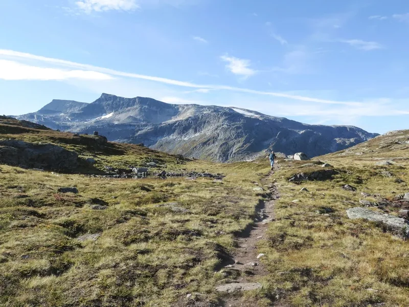
Stage 3: The High Plateau and Bjørnbøltjønne
- Distance: 5 km
- Elevation: Rolling terrain
- Time: 2–3 hours
- After the initial climb, the trail levels out onto a high alpine plateau.
- You will pass the small lake of Bjørnbøltjønne, a good spot for a first break and to refill water from the mountain streams.
- The terrain here is easier, allowing you to make good time before reaching the base of the ridge.
- Views of the surrounding 2,000-metre peaks of Jotunheimen begin to open up in all directions.
Stage 4: The Besseggen Ridge (The Scramble)
- Distance: 1.5 km
- Elevation Gain: 300 m
- Time: 1–1.5 hours
- This is the highlight of the trek. The trail narrows significantly as you approach the "Bandet"—the strip of land between the two lakes.
- The scramble involves using your hands in several places to pull yourself up the rocky spine.
- While not technically difficult climbing, it is highly exposed. If you suffer from vertigo, this is the most challenging section.
- Pause frequently to look back; this is where you get the iconic photo of the green and blue lakes separated by the ridge.
Stage 5: Veslefjellet Summit
- Distance: 1 km
- Elevation: Reaching 1,743 m
- Time: 30–45 minutes
- Once the scramble is complete, you reach the broad, stony summit of Veslefjellet.
- A massive stone cairn marks the highest point of the hike.
- On a clear day, you can see across the entire Jotunheimen range to the west and the Rondane mountains to the east.
Stage 6: The Descent to Gjendesheim
- Distance: 4.5 km
- Elevation Loss: 750 m
- Time: 2–2.5 hours
- The descent is long and can be taxing on the knees. The trail follows a ridge line before dropping steeply towards Gjendesheim.
- There are some sections with fixed chains to assist in steep or slippery areas.
- As you descend, the Gjendesheim lodge comes into view, marking the end of the journey.
- Celebrate with a traditional Norwegian meal at the lodge upon arrival.
Planning and Bookings
Book Your Trip
Everything you need to plan your journey
Accommodation
Find places to stay near Lom
Flights
Search flights to Lom
Essential Preparation
Besseggen is a demanding hike that requires a solid level of physical fitness. You should be comfortable walking for 8 to 10 hours on uneven, rocky terrain with significant elevation changes. Preparation should begin with booking the Gjende boat, as this is the primary logistical bottleneck. During July and August, boats can sell out weeks in advance. It is highly recommended to base yourself in the area for at least two nights to allow for a "weather window"—if the wind is too high or visibility too low, you will want the flexibility to move your hike to the following day.
The nearest town with full services is Lom, famous for its stave church and bakery. However, most hikers stay at the trailheads. Access to Gjendesheim is straightforward via the "Valdresekspressen" bus from Oslo, which takes approximately 4.5 to 5 hours. If driving, follow the E6 to Otta and then Road 15 and 51 to Gjendesheim. Note that Road 51 (Valdresflye) is a National Tourist Route and is closed in winter, typically opening in May.
Trail Accommodation
There are several excellent accommodation options specifically positioned for the Besseggen hike. These range from full-service mountain lodges to campsites.
Gjendesheim Turisthytte: The flagship DNT lodge located at the eastern end of Lake Gjende. It offers both private rooms and dormitory-style "bunk" accommodation. Facilities include a large restaurant serving local food, hot showers, a drying room for wet gear, and a small shop. Booking is essential during the summer season. DNT members receive a significant discount.
Memurubu Fjellstue: Located at the midpoint of Lake Gjende, this is the starting point for the classic hike. It is a private lodge but operates similarly to DNT huts. It is accessible only by boat or by hiking. Staying here the night before your hike allows you to start early before the first boat from Gjendesheim arrives, giving you the ridge to yourself for a few hours.
Bessheim Fjellstue: Located about 5 kilometres from Gjendesheim on the shores of Lake Øvre Sjodalsvatnet. This is a great alternative if Gjendesheim is full. It offers cabins, rooms, and a campsite. It is a historic lodge with a very high standard of local cuisine, specialising in reindeer and mountain trout.
Camping: Wild camping is permitted in Jotunheimen National Park under the "Allemannsretten" (Right to Roam) laws, provided you are at least 150 metres from inhabited buildings and follow Leave No Trace principles. However, the terrain around Besseggen is very rocky and exposed; finding a flat, sheltered spot can be difficult. There are organised campsites at Bessheim and Maurvangen (near Gjendesheim) with full facilities.
Required Gear
- Hiking Boots: Sturdy, waterproof boots with good ankle support are non-negotiable. The terrain is almost entirely rock and scree, which will shred lightweight trainers and lead to rolled ankles.
- Waterproof Shell: A high-quality Gore-Tex (or equivalent) jacket and overtrousers. Even on a sunny day, the wind on the ridge can be piercing, and rain can arrive without warning.
- Insulating Layers: A fleece or wool mid-layer, plus a lightweight down or synthetic jacket for rest stops. Avoid cotton, which retains moisture and leads to rapid cooling.
- Navigation: A physical map (Turkart 1:50,000 Jotunheimen Aust) and a compass. While the trail is marked, fog can make finding the next "T" difficult. A GPS or offline smartphone map (like UT.no) is a vital backup.
- Head Torch: Even in the season of long days, a late-afternoon injury could see you finishing in the dark.
- First Aid Kit: Must include blister plasters (Compeed), antiseptic wipes, and a survival bag or emergency bivy.
What to Bring
- Food: High-energy snacks (nuts, chocolate, dried fruit) and a substantial lunch. There are no facilities to buy food once you leave the lodges. Traditional Norwegian "matpakke" (open-faced sandwiches) are the standard trail fuel.
- Water: At least 2 litres. While you can refill from streams in the first and last thirds of the hike, the middle section (the ridge and Veslefjellet) is dry. Ensure you collect water from fast-flowing sources above any livestock grazing areas.
- Sun Protection: SPF 50 sunscreen, lip balm with UV protection, and high-quality sunglasses. The sun is exceptionally strong at high altitudes and reflects off the water and snow patches.
- Gloves and Beanie: Even in July, temperatures on the 1,743-metre summit can be near freezing with wind chill. Lightweight liners and a windproof hat are essential.
- Power Bank: Cold temperatures drain phone batteries quickly. Ensure you have a way to keep your navigation and emergency communication devices charged.
Permits
There is no permit required to hike Besseggen Ridge or to enter Jotunheimen National Park. Norway's "Allemannsretten" ensures free access to the countryside for everyone. However, the logistical "permit" you must secure is the boat ticket.
Gjende Boat Bookings:
- The boat (Gjendebåten) operates from mid-June to late September.
- Tickets must be booked online in advance via the official Gjende boat website. During peak season (July), boats often sell out days or weeks in advance.
- There are multiple departures daily, usually starting around 7:30 AM. The earliest boats are the most popular.
- Cost: Approximately 200–250 NOK for a one-way adult ticket.
- If you miss your booked boat, you are not guaranteed a spot on the next one. Arrive at the pier at least 20 minutes before departure.
Parking Fees:
- Parking at the Gjendesheim trailhead is restricted. There is a large long-term car park at Reinsvangen (Maurvangen), about 2 kilometres from the pier.
- A shuttle bus runs frequently between the car park and the boat pier (included in the parking fee).
- Parking fees are approximately 150–200 NOK per day. Payment is usually via an automated system or a mobile app (EasyPark).
DNT Membership: While not a permit, joining the Norwegian Trekking Association (DNT) is highly recommended. Membership provides significant discounts on lodge stays and supports the maintenance of the trail markings and bridges throughout Jotunheimen.

Wakahi Guide
Detailed route notes, maps, logistics & tips for the Besseggen Ridge (PDF).
Other Activities in the Area
Jotunheimen is a vast playground. If you have extra days, consider these nearby adventures:
- Galdhøpiggen: Hike to the highest point in Northern Europe (2,469 m). Accessible from Juvasshytta (requires a guided glacier traverse) or Spiterstulen (a long, steep hike on rock).
- Knutshøe: Often called "Besseggen's little brother," this ridge sits directly across Lake Gjende. It offers similar views but is unmasked and requires more technical scrambling. It is much less crowded.
- Lom Stave Church: Visit one of Norway's largest and most beautiful stave churches, dating back to the 12th century. Located in the town of Lom, a 45-minute drive from Gjendesheim.
- Sognefjellsvegen: Drive Northern Europe's highest mountain pass (Road 55). The scenery is otherworldly, with glaciers and high peaks visible from the car window.
- Rafting on the Sjoa River: For an adrenaline rush, the Sjoa River offers some of the best white-water rafting in Europe, with various levels of difficulty available.
- Glacier Hiking: Join a guided tour on the Bøverbreen or Svellnosbreen glaciers to experience the blue ice and crevasses of the high fells safely.
Safety and Conditions
The "Point of No Return": On the Besseggen hike, there is a psychological and physical point of no return once you begin the steep scramble up the ridge from the "Bandet". Descending this section is significantly more difficult and dangerous than ascending it. If you reach the base of the ridge and feel uncomfortable with the exposure, or if the weather is deteriorating, it is better to turn back towards Memurubu or take the lower path along the shore of Lake Bessvatnet back to Gjendesheim.
Exposure and Vertigo: The ridge is narrow. In some places, you will have steep drops on both sides. While thousands of people do this safely every year, it is not suitable for those with severe acrophobia. On windy days, the gusts can be strong enough to knock a person off balance; in such conditions, it is safer to stay low and use three points of contact (hands and feet) at all times.
Hypothermia Risk: Even in summer, the temperature on Veslefjellet can be 10–15 degrees Celsius lower than at the lake level. Combined with wind and rain, hypothermia is a genuine risk for ill-prepared hikers. Always carry a dry base layer in a waterproof bag and put on your shell layers *before* you start shivering.
Emergency Communication: Mobile signal is generally good along the ridge, but there are "dead zones" in the valleys and behind large rock masses. In an emergency, call 112. Be prepared to give your coordinates (use a map app or GPS). Note that mountain rescues in Norway are carried out by the volunteer Red Cross or the military Sea King helicopters, but they should only be summoned in life-threatening situations.
Snow and Ice: In June and early July, the descent to Gjendesheim can be very slippery due to melting snow. Trekking poles are highly recommended to provide extra stability on these sections.
Side Trips and Points of Interest
Besshøe (2,258 m): For those with exceptional fitness, a detour to the summit of Besshøe offers one of the most commanding views in all of Norway. This peak towers over Lake Bessvatnet. The ascent is steep and adds several hours to the day, but the perspective looking down onto the Besseggen ridge makes it look like a tiny thread in the landscape. This is best done as a separate day trip from Gjendesheim or Bessheim.
The "Bandet" Isthmus: This is the narrow strip of rock that separates the two lakes. It is a fascinating geological feature. Take a moment here to touch the water of both lakes; you will notice that Bessvatnet is significantly colder than Gjende. This is also the lowest point before the big scramble begins.
Jo Gjende’s Hut: Near Memurubu, you can find the remains of the hut belonging to Jo Gjende (1794–1884), a legendary Norwegian outdoorsman, reindeer hunter, and sharpshooter. He was a local folk hero who lived a solitary life in the mountains and is said to have been the inspiration for some of the characteristics of Peer Gynt. His life represents the rugged, independent spirit of the Jotunheimen region.
Veslefjellet Stone Cairn: The summit of Veslefjellet is marked by one of the largest trail cairns in Norway. It is a tradition for hikers to add a small stone to the pile, though in recent years, park authorities have discouraged this to prevent erosion and the disturbance of the surrounding alpine soil. The cairn serves as a vital navigational landmark in poor visibility.
Leave No Trace
Jotunheimen is a protected National Park, and its alpine ecosystem is extremely fragile. The growing season at 1,500 metres is only a few weeks long, meaning a single footstep off-trail can destroy plants that have taken years to grow. With 60,000 visitors a year, the cumulative impact is significant.
Protecting the Giants' Home:
- Stay on the marked path: The red "T"s are there for a reason. Braiding trails (creating multiple parallel paths) causes massive soil erosion and destroys the reindeer lichen.
- Pack it out: There are no bins on the trail. This includes organic waste like orange peels and banana skins, which can take years to decompose in the cold, dry alpine climate.
- Respect the Reindeer: Jotunheimen is home to wild reindeer herds. If you are lucky enough to see them, keep a distance of at least 300 metres. Do not use drones, as they cause significant stress to the animals.
- Human Waste: Use the facilities at the lodges before you start. If you must go on the trail, ensure you are at least 50 metres from any water source and bury waste in a "cathole" 15 cm deep, or better yet, use a "pack-it-out" bag.
- No Rock Stacking: Do not build new cairns or move rocks. This disturbs the habitat of small insects and contributes to erosion.