Berliner Höhenweg - The Heart of the Zillertal Alps
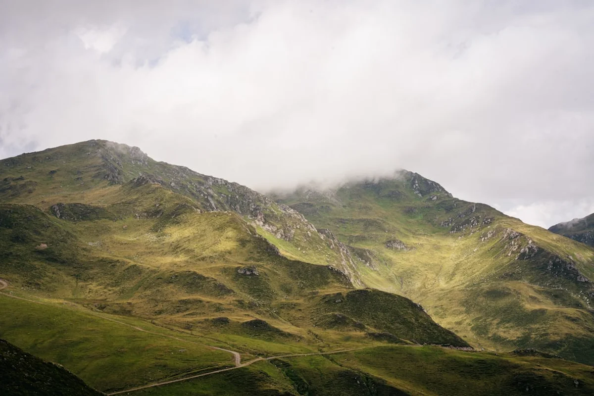
The Berliner Höhenweg, also known as the Zillertaler Runde, is one of the most prestigious and demanding high-altitude trekking routes in the Austrian Alps. Spanning approximately 93.3 kilometres through the high-alpine heart of the Zillertal Alps Nature Park, this circular journey is a masterclass in mountain grandeur. It is a trail that does not merely skirt the edges of the peaks but dives deep into a world of granite spires, sprawling glaciers, and turquoise reservoirs. Over the course of six to eight days, hikers traverse a landscape that transitions from lush Tyrolean meadows to stark, glaciated passes reaching elevations of over 3,000 metres. This is not a journey for the faint-hearted; it is a serious undertaking that requires physical stamina, sure-footedness, and a deep respect for the volatile nature of high-mountain environments.
What distinguishes the Berliner Höhenweg from other alpine routes is its unique blend of raw natural beauty and rich mountaineering heritage. The trail connects eight historic mountain huts, including the legendary Berliner Hütte—a protected monument and a "Grand Hotel" of the Alps that evokes the golden age of mountaineering. Each stage of the journey presents a new challenge, from the steep ascent of the Schönbichler Horn to the technical navigation of the Siebenschneidensteig. The route is a loop, traditionally beginning in the village of Finkenberg and concluding with a dramatic descent back into the bustling mountaineering hub of Mayrhofen. For those who seek the ultimate Austrian trekking experience, the Berliner Höhenweg offers a profound immersion into the silence and scale of the high Zillertal.
- Distance: 93.3 km circular loop
- Duration: 6–8 days
- Season: July to September (strictly dependent on snow conditions and hut opening dates)
- Huts: Gamshütte, Friesenberghaus, Olpererhütte, Furtschaglhaus, Berliner Hütte, Greizer Hütte, Kasseler Hütte, Karl-von-Edel-Hütte
- Highest point: Schönbichler Horn (3,134 m)
- Total Elevation Gain: Approximately 7,052 m
- Difficulty: Challenging (classified as "Black Mountain Paths" by the Austrian Alpine Club)
- Direction: Traditionally walked counter-clockwise from Finkenberg to Mayrhofen
Overview
The Berliner Höhenweg is a high-alpine odyssey that demands a high level of physical fitness and mountain experience. Unlike lower-level valley walks, this trail remains almost entirely above the treeline, often hovering between 2,000 and 3,000 metres. The terrain is characterised by rugged block-fields, narrow ridges, steep couloirs, and sections secured with steel cables. It is a landscape defined by the power of ice; although the glaciers of the Zillertal are receding, their presence is felt everywhere—in the scouring of the granite walls, the milky blue of the glacial streams, and the massive moraines that hikers must navigate. The trail offers a front-row seat to some of Austria's most iconic peaks, including the Hochfeiler (3,510 m), the Großer Möseler (3,480 m), and the Olperer (3,476 m).
The route is structured around the concept of "hut-to-hut" trekking, a quintessentially European experience where the day's physical exertion is rewarded by the warmth and camaraderie of an alpine refuge. However, the Berliner Höhenweg is far from a leisurely stroll between hotels. The stages are long, often requiring 6 to 9 hours of active movement, and the cumulative elevation gain of over 7,000 metres tests the endurance of even seasoned trekkers. The weather in the Zillertal Alps is notoriously fickle; even in the height of summer, a sudden cold front can bring snow to the higher passes, turning a challenging hike into a technical mountaineering exercise. This unpredictability is part of the trail's character, requiring hikers to be self-reliant, well-equipped, and mentally prepared for the rigours of the high mountains.
The circular nature of the trail provides a sense of completion that is deeply satisfying. Starting in the lower valleys near Mayrhofen, you slowly ascend into the high-alpine zone, circling the massive Zillertal main ridge before descending back to the valley floor. Along the way, you encounter a variety of micro-environments: from the flower-strewn slopes of the Gamshütte to the stark, moon-like landscape of the Mörchnerscharte. The trail is a testament to the engineering and dedication of the Austrian and German Alpine Clubs (ÖAV and DAV), who maintain the paths and huts in this inhospitable terrain. For the modern trekker, the Berliner Höhenweg is more than just a hike; it is a pilgrimage through the history and geology of the Eastern Alps.
History and Cultural Context
The history of the Berliner Höhenweg is inextricably linked to the development of mountaineering in the 19th century. The trail takes its name from the Berlin Section of the German Alpine Club (DAV), which was instrumental in exploring the Zillertal Alps and building the infrastructure that exists today. In the late 1800s, as the industrial revolution created a new middle class in European cities, the mountains were transformed from feared, "god-forsaken" places into destinations for recreation and scientific study. The Berlin Section, being one of the wealthiest and most active branches of the Alpine Club, chose the Zillertal as its primary area of activity, funding the construction of paths and huts that were remarkably ambitious for their time.
The centrepiece of this historical legacy is the Berliner Hütte. Built in 1879 and expanded several times, it was the first mountain hut in the Zillertal and remains the largest. Its architecture is a far cry from the simple stone shelters of the era; with its wood-panelled dining halls, high ceilings, and grand staircase, it was designed to provide a level of comfort that mirrored the grand hotels of Berlin. In 1997, the Berliner Hütte became the first mountain hut in Austria to be placed under monumental protection, ensuring that its unique historical character is preserved for future generations. Walking the Berliner Höhenweg is, in many ways, a journey through this "Golden Age" of alpinism, where the spirit of early explorers like Peter Habeler (a Zillertal native who, with Reinhold Messner, was the first to climb Everest without supplemental oxygen) still permeates the air.
Beyond the mountaineering history, the Zillertal Alps have a deep cultural connection to the local farming communities. For centuries, the high pastures (Alms) have been used for seasonal grazing, and the traditional "Transhumance"—the movement of livestock between valley and mountain—remains a vital part of Tyrolean identity. The trail passes through areas where the sounds of cowbells and the sight of hardy Haflinger horses are common. This intersection of high-alpine wilderness and ancient agricultural tradition creates a cultural landscape that is uniquely Austrian. The Zillertal Alps Nature Park, established in 2001, now protects this delicate balance, ensuring that the biodiversity and cultural heritage of the region are managed sustainably in the face of increasing tourism and climate change.
Want more background? Read extended notes on history and cultural context → Learn more
Seasonal Highlights and Weather Reality
The window for successfully completing the Berliner Höhenweg is remarkably narrow, typically spanning from early July to mid-September. This is dictated by the presence of snow on the high passes and the operational dates of the mountain huts. Outside of this window, the trail transitions from a challenging trek to a serious winter mountaineering route, requiring specialized equipment and expertise in avalanche safety.
July: This is the month of the "Alpine Spring." While the valleys are in full summer bloom, the high-altitude sections of the trail are just beginning to shed their winter coat. Hikers in July should expect to encounter significant snow patches on the north-facing slopes and high passes like the Mörchnerscharte and the Schönbichler Horn. Trekking poles and sometimes even light crampons (spikes) are highly recommended. The benefit of July is the abundance of wildflowers and the dramatic sight of melting glaciers feeding roaring waterfalls.
August: Generally the most stable month for weather and the time when the trail is most likely to be snow-free. This is the peak season, meaning the huts are often fully booked and the trail is at its busiest. While the days are warm, afternoon thunderstorms are a common occurrence in the Alps. These "Wärmegewitter" can develop rapidly, bringing heavy rain, lightning, and sudden drops in temperature. Hikers should aim to reach their destination hut by early afternoon to avoid being caught on exposed ridges during a storm.
September: Many experienced trekkers consider September the best time for the Berliner Höhenweg. The air is crisper and clearer, providing the best visibility for the expansive mountain panoramas. The summer crowds begin to thin, and the huts take on a quieter, more contemplative atmosphere. However, the days are shorter, and the risk of early-season snowfall increases. By late September, most huts begin to close for the winter, and the first heavy snows can effectively end the trekking season.
Weather Reality: Regardless of the month, hikers must understand that the Zillertal Alps create their own weather systems. Temperature fluctuations can be extreme; a sunny 20°C day in the valley can easily be 2°C with sleet at 3,000 metres. Hypothermia is a genuine risk for those who are under-equipped. Always check the "Bergwetter" (mountain weather) forecasts provided by the Austrian Alpine Club or local tourism offices before setting out each morning.
Recommended Itinerary
8-Day Berliner Höhenweg Itinerary
Day 1: Finkenberg to Gamshütte
- Distance: 8.5 km
- Elevation gain: 1,100 m
- Time: 3.5–4.5 hours
- Start in Finkenberg (accessible by bus from Mayrhofen)
- Steep ascent through dense forest and alpine meadows
- Pass the Hermann-Hecht-Weg, a well-maintained but relentless climb
- Arrive at Gamshütte (1,921 m), perched on a grassy shoulder with views over the Tuxer Alps
- A shorter day distance-wise, but the 1,100 m vertical gain is a significant "wake-up call" for the legs
- The hut is famous for its hospitality and traditional Tyrolean cuisine
Day 2: Gamshütte to Friesenberghaus
- Distance: 14.5 km
- Elevation gain: 1,100 m gain, 500 m loss
- Time: 7–9 hours
- A long, demanding day traversing the slopes of the Grinbergspitzen
- The trail is often narrow and requires concentration, crossing several steep gullies
- Pass through the "Graue Platte" (Grey Slab) area, requiring sure-footedness
- Arrive at Friesenberghaus (2,498 m), located near the beautiful Friesenbergsee lake
- This stage is known for its solitude and the feeling of truly entering the high-alpine zone
Day 3: Friesenberghaus to Furtschaglhaus via Olpererhütte
- Distance: 13 km
- Elevation gain: 600 m gain, 800 m loss
- Time: 5–6 hours
- High-altitude traverse with spectacular views of the Schlegeis Reservoir
- Pass the Olpererhütte (2,388 m), famous for its "Instagram-famous" suspension bridge nearby
- Descent to the Schlegeis Reservoir (1,782 m) before a final ascent
- Climb through the Furtschaglbach valley to reach Furtschaglhaus (2,295 m)
- The view from Furtschaglhaus towards the Hochfeiler and its glacier is one of the trail's highlights
Day 4: Furtschaglhaus to Berliner Hütte via Schönbichler Horn
- Distance: 8.5 km
- Elevation gain: 900 m gain, 1,150 m loss
- Time: 6–7 hours
- The "Queen Stage" of the trek, crossing the highest point of the route
- Steep ascent to the Schönbichler Horn (3,134 m); the final section is secured with steel cables
- Breathtaking 360-degree views of the Zillertal main ridge from the summit
- Long, technical descent over granite blocks and moraines into the upper Zemmgrund
- Arrive at the historic Berliner Hütte (2,042 m), a monumental building in a stunning glacial cirque
Day 5: Berliner Hütte to Greizer Hütte via Mörchnerscharte
- Distance: 10.5 km
- Elevation gain: 1,200 m gain, 1,000 m loss
- Time: 7–8 hours
- Descent into the Schwarzensteinalm before a long, steep climb to the Mörchnerscharte (2,876 m)
- The ascent to the Scharte (pass) is very steep and often involves crossing snowfields
- The descent on the other side is equally steep, secured with cables in the upper section
- Traverse the Floitengrund valley to reach the Greizer Hütte (2,227 m)
- A physically exhausting day that rewards with raw, glaciated scenery
Day 6: Greizer Hütte to Kasseler Hütte via Floitenscharte
- Distance: 14.5 km
- Elevation gain: 1,100 m gain, 1,150 m loss
- Time: 8–9 hours
- Another long and technical stage, often considered the most difficult by many hikers
- Climb to the Floitenscharte (2,683 m), requiring careful navigation through boulder fields
- The descent into the Stillupgrund is long and requires sustained focus
- Traverse high above the valley floor on the "Siebenschneidensteig" (Path of Seven Cutting Edges)
- Arrive at Kasseler Hütte (2,178 m), overlooking the Stillup Reservoir
Day 7: Kasseler Hütte to Karl-von-Edel-Hütte
- Distance: 13 km
- Elevation gain: 800 m gain, 750 m loss
- Time: 8–9 hours
- The "Siebenschneidensteig" continues, crossing seven distinct mountain ribs (ridges)
- This is a mentally taxing day; while the elevation gain isn't the highest, the constant up-and-down is tiring
- The path is rugged and requires constant attention to footing
- Arrive at Karl-von-Edel-Hütte (2,238 m), situated beneath the Ahornspitze
- Final night in the high mountains with views down into the Mayrhofen valley
Day 8: Karl-von-Edel-Hütte to Mayrhofen
- Distance: 10 km (or 0 km if using cable car)
- Elevation loss: 1,600 m
- Time: 3–4 hours (descent)
- Optional ascent of the Ahornspitze (2,973 m) for those with remaining energy (3 hours return)
- Long descent through alpine pastures and forest back to Mayrhofen
- Alternatively, walk 1 hour to the Ahorn cable car mountain station and ride down to Mayrhofen
- Celebrate the completion of the loop in the vibrant centre of Mayrhofen
Important Notes:
- The trail is a circular loop; it can be shortened by exiting at various points (e.g., Schlegeis, Stillup)
- Sure-footedness and a head for heights are essential for the passes and cable-secured sections
- Hut bookings are mandatory and should be made months in advance
- The direction is traditionally counter-clockwise, but it can be walked in reverse
- Always check with hut wardens about current conditions on the next day's pass
Planning and Bookings
Book Your Trip
Everything you need to plan your journey
Accommodation
Find places to stay near Mayrhofen
Flights
Search flights to Mayrhofen
Essential Preparation
The Berliner Höhenweg is a serious mountain undertaking that requires meticulous planning. The first step is assessing your own fitness and experience. This is a "Black" rated trail, meaning it involves technical terrain, significant exposure, and long days. You should be comfortable walking 8–9 hours a day with a 10–12 kg pack and have experience navigating rocky, uneven ground. Training should focus on cardiovascular endurance and leg strength, ideally including several long day hikes with significant elevation gain in the weeks leading up to your trip.
Logistically, Mayrhofen is your primary base. It is easily accessible from Innsbruck, Munich, or Salzburg via the Austrian Federal Railways (ÖBB) and the local Zillertalbahn train. Most hikers spend a night in Mayrhofen or Finkenberg before starting to acclimatise and organise last-minute supplies. There are numerous outdoor shops in Mayrhofen where you can buy gas canisters, maps, or replace forgotten gear. Booking your huts is the most critical part of preparation; the Berliner Höhenweg is popular, and beds in the smaller huts (like Gamshütte or Greizer Hütte) fill up very quickly for the July–August season.
Trail Accommodation
Accommodation on the Berliner Höhenweg is provided by eight mountain huts, most of which are owned and operated by the German or Austrian Alpine Clubs (DAV/ÖAV). These huts are marvels of alpine logistics, supplied by helicopter or material ropeways, and offer a unique communal atmosphere.
Hut Facilities:
- Sleeping options: "Zimmerlager" (small rooms with 2–4 beds) or "Matratzenlager" (large dormitory-style rooms with shared mattresses)
- Dining: Most huts offer "Halbpension" (half-board), which includes a multi-course dinner and breakfast. This is highly recommended
- Water: Potable water is generally available, though some huts may charge for showers due to water scarcity at high altitudes
- Toilets: Modern flushing toilets or high-tech composting systems are standard
- Drying rooms: Essential for drying boots and wet clothing after a rainy day
- Electricity: Available for charging phones in common areas, though outlets are limited
What Huts Don't Provide:
- Bed linen: You MUST bring a lightweight silk or cotton sleeping bag liner (Hüttenschlafsack) for hygiene
- Towels and toiletries: You must bring your own
- WiFi: Most huts have no WiFi, and mobile signal is patchy at best
- Free showers: Expect to pay €3–€5 for a 3-minute hot shower
Booking and Costs:
- Bookings: Most huts can be booked online via the "Alpenverein" booking platform. It is advisable to book 4–6 months in advance
- Costs: A night in a dormitory for an Alpine Club member is approximately €15–€25; for non-members, it is €25–€40. Half-board typically adds €35–€45 per day
- Membership: Joining the ÖAV, DAV, or an affiliated club (like the Austrian Alpine Club UK) is highly recommended. It provides significant discounts on hut stays and includes mountain rescue insurance
Required Gear
- Boots: High-quality, waterproof trekking boots with a stiff sole (Category B or B/C). Ankle support is non-negotiable for the rocky terrain
- Backpack: 35–45 litres is usually sufficient for hut-to-hut trekking. Ensure it has a good rain cover
- Clothing: A layering system is essential. Include moisture-wicking base layers (merino is best), an insulating mid-layer (fleece or light down), and a high-quality waterproof/breathable shell jacket and trousers
- Navigation: Physical map (Alpenvereinskarte 35/1 and 35/2), a compass, and a GPS device or smartphone with offline maps (e.g., Outdooractive or Komoot)
- Safety: A basic first-aid kit, an emergency bivy bag (Biwaksack), and a headlamp with spare batteries
- Trekking poles: Highly recommended to save your knees on the long descents and provide stability on snowfields
What to Bring
- Sleeping bag liner: Silk or cotton (mandatory for hut hygiene)
- Cash: Many huts do not accept credit cards. Carry enough Euros to cover your stay, meals, and drinks (approx. €60–€80 per day)
- Water treatment: While hut water is usually safe, a lightweight filter or tablets are useful for refilling from streams between huts
- Sun protection: High-factor sunscreen, lip balm with SPF, sunglasses (Category 3 or 4), and a wide-brimmed hat. The alpine sun is intense
- Personal hygiene: Biodegradable soap, travel towel, toothbrush, and earplugs (essential for dormitories)
- Snacks: High-energy foods like nuts, dried fruit, and energy bars. You can buy "Marschtee" (hiking tea) and packed lunches at the huts
- Alpine Club membership card: To receive your discounts
Permits

There is no formal "permit" required to hike the Berliner Höhenweg. The trail is located within the Zillertal Alps Nature Park, which is open to the public. However, the "de facto" permit is your hut reservation. Because wild camping is strictly prohibited throughout the Zillertal Alps and the Nature Park, you must have a confirmed place to stay each night. During the peak months of July and August, the huts operate at full capacity, and wardens may turn away hikers who arrive without a booking if the hut is dangerously overcrowded.
Wild Camping Regulations: It is important to emphasize that wild camping (including bivouacking) is illegal in the Tyrolean mountains, especially within the Nature Park. Fines can be substantial, and the regulation is strictly enforced to protect the fragile alpine ecosystem and prevent disturbance to wildlife. The only exception is an "emergency bivouac" in the event of an injury or sudden weather change that prevents you from reaching a hut.
Alpine Club Membership: While not a permit, membership in the Austrian Alpine Club (ÖAV) or German Alpine Club (DAV) is practically essential for this trek. Membership provides:
- Up to 50% discount on overnight stays in Alpine Club huts
- Comprehensive mountain rescue insurance (including helicopter evacuation), which is vital given the technical nature of the trail
- Reciprocal rights to discounts in huts across the Alps (Switzerland, France, Italy)
- Access to detailed maps and route information
Other Activities in the Area
The Zillertal is one of Austria's most diverse tourism regions, offering plenty of options for those who want to extend their stay or have family members not joining the trek:
- Hintertux Glacier: Austria's only year-round ski resort. Even in summer, you can take the cable car to 3,250 metres for skiing, visiting the "Nature's Ice Palace" (a natural crevasse system), or simply enjoying the views from the Panorama Terrace.
- Schlegeis Reservoir: A stunning turquoise lake at the base of the Olperer. You can take a guided tour inside the massive dam wall, try the "Schlegeis 131" climbing route, or simply enjoy a walk along the shore.
- Mayrhofen Adventure Pool: A great place to relax tired muscles after the trek, featuring indoor and outdoor pools, saunas, and wellness facilities.
- Zillertalbahn: A historic narrow-gauge railway that runs through the valley. The steam train excursions are a nostalgic way to see the region.
- Via Ferrata (Klettersteig): The Zillertal is a hub for via ferrata. Popular routes include the "Huterlaner," "Pfeilspitzwand," and the "Zimmereben" near Mayrhofen, ranging from beginner to expert difficulty.
- Paragliding: Mayrhofen is a world-renowned spot for paragliding. Tandem flights from the Penken or Ahorn mountains offer a bird's-eye view of the peaks you've just walked.
Safety and Conditions
Technical Difficulty: The Berliner Höhenweg is classified as a "Black Mountain Path." This means the trail is often narrow, very steep, and includes sections where you must use your hands for balance. Steel cables are provided in the most exposed areas, but you should be comfortable with heights (vertigo-free). The "Siebenschneidensteig" and the ascent of the Schönbichler Horn are the most technical sections.
Alpine Hazards:
- Rockfall: Always a risk in high-alpine terrain, especially after heavy rain or when other hikers are above you. Wear a helmet if you feel uncomfortable in steep couloirs.
- Snowfields: Even in August, you may have to cross steep snow patches. If the snow is hard-frozen (common in the morning), it can be extremely slippery. Use trekking poles and consider carrying "micro-spikes" for added traction.
- Lightning: Summer thunderstorms are the greatest weather threat. If a storm approaches, descend from ridges and peaks immediately. Avoid standing near isolated trees or water sources.
Emergency Protocol: The European emergency number is 112. In Austria, the specific mountain rescue number is 140. Be aware that mobile phone reception is non-existent in many of the deep valleys and high passes. If you cannot call for help, the "Alpine Distress Signal" is to give a visible or audible signal (whistle, light, shout) six times a minute, then wait a minute and repeat. The answer is three signals per minute.
Fitness and Health: Do not underestimate the cumulative fatigue of 7,000 metres of elevation gain. Listen to your body. If you are feeling exhausted, there are several "escape routes" where you can descend to the valley from almost every hut. Knee pain is common on the long descents; use poles and take frequent breaks. Ensure you are drinking at least 3 litres of water a day to stay hydrated at altitude.
Side Trips and Points of Interest
Schönbichler Horn (3,134 m): While the trail passes just below the summit, the short scramble to the actual peak is the highlight for many. It is the highest point of the Berliner Höhenweg and offers an unparalleled view of the Waxeggkees and Hornkees glaciers. On a clear day, you can see as far as the Grossglockner to the east and the Zugspitze to the west.
The Olperer Bridge: Located just a few minutes from the Olpererhütte, this small suspension bridge has become a global sensation on social media. It is perfectly positioned to create an optical illusion where the bridge appears to hang thousands of metres above the Schlegeis Reservoir. It's worth the short detour for the photograph, but expect a queue during peak hours.
Berliner Hütte Architecture: Take the time to explore the interior of the Berliner Hütte. The "Damensalon" (Ladies' Lounge) and the grand dining hall with its ornate wood carvings and chandeliers are a testament to the luxury of 19th-century mountaineering. The hut also has its own post office and a small museum section dedicated to the history of the Berlin Section of the DAV.
Ahornspitze (2,973 m): For those with energy left on the final day, the ascent from the Karl-von-Edel-Hütte to the summit of the Ahornspitze is highly rewarding. It is a challenging scramble (approx. 3 hours return) that provides a final, dramatic look back at the entire Zillertal main ridge before you descend to Mayrhofen.
Friesenbergsee: A crystal-clear alpine lake near the Friesenberghaus. It's a perfect spot for a (very cold) dip or to sit and watch the reflection of the peaks in the still water. The area around the lake is also home to many marmots; listen for their distinctive high-pitched whistles.
Leave No Trace
The Zillertal Alps Nature Park is a protected area that provides a habitat for rare species like the Alpine Ibex, Chamois, and the Golden Eagle. The high-alpine environment is extremely fragile; plants grow slowly at this altitude, and a single footprint off-trail can cause damage that takes years to heal. As a hiker, you have a responsibility to minimise your impact.
Core Principles for the Berliner Höhenweg:
- Carry out all trash: This includes organic waste like banana peels or apple cores, which decompose very slowly in the cold alpine climate and can be harmful to local wildlife.
- Stay on the marked path: The Zillertal granite is prone to erosion. Cutting switchbacks destroys vegetation and leads to trail degradation.
- Respect the "Hüttenruhe": Most huts have a quiet period from 10:00 PM to 6:00 AM. Respect your fellow hikers and the hut staff by keeping noise to a minimum.
- Water Protection: Do not use soap or detergent in alpine lakes or streams. Even "biodegradable" soaps can disrupt the delicate chemical balance of high-altitude water bodies.
- Wildlife: Observe animals from a distance. Do not feed them. Marmots and birds can become dependent on human food, which lacks the nutrients they need to survive the harsh winter.
- Human Waste: Use the facilities at the huts. If you are caught between huts, move at least 50 metres from any water source and bury waste in a "cathole" or, better yet, use a "pack-it-out" bag.
Useful Links
- Zillertal Tourism - Berliner Höhenweg Official Guide
- ÖAV Hut Finder and Booking Portal
- German Alpine Club (DAV) - English Site
- Zillertal Alps Nature Park Official Site
- ZAMG - Austrian Mountain Weather Forecast
- ÖBB - Austrian Federal Railways (Train Timetables)
- Austrian Alpine Club (UK Section) - Membership for English Speakers