Canada — Jasper
Canada's Berg Lake Trail is a moderate 42km route through Mount Robson Provincial Park, leading to the base of the Canadian Rockies' highest peak. This world-class wilderness trek offers stunning panoramas of glaciers and alpine lakes, with a 3-5 day duration. Expect varied terrain and a truly memorable mountain vista.
Distance: 42.0 km
Elevation Gain: 800 m
Difficulty: Moderate
Duration: 3-5 days
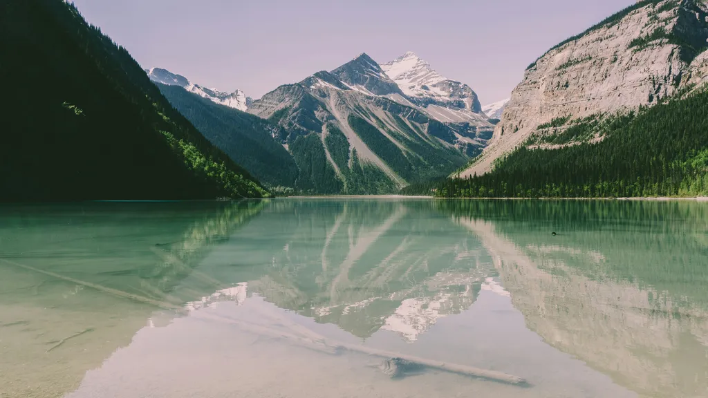
The Berg Lake Trail is widely considered the crown jewel of the Canadian Rockies, a world-class backcountry trekking experience that leads hikers to the base of the north face of Mount Robson. Standing at 3,954 metres, Mount Robson is the highest peak in the Canadian Rockies, a monolithic giant of layered sedimentary rock that creates its own weather systems and dominates the horizon of British Columbia’s Mount Robson Provincial Park. The trail itself is a 42-kilometre return journey that traverses three distinct ecological zones, beginning in a lush, temperate rainforest of ancient cedars and hemlocks before ascending through the dramatic "Valley of a Thousand Falls" to the high alpine tundra of the Berg Lake basin. Here, the massive Berg Glacier spills directly into the turquoise waters of the lake, frequently calving house-sized chunks of ice that thunder into the depths with a sound like distant artillery.
This is not merely a hike; it is a pilgrimage into the heart of a UNESCO World Heritage site. The route offers an unparalleled showcase of glacial geology, from the turquoise silt-laden waters of Kinney Lake to the mist-shrouded heights of Emperor Falls. Whether you are a seasoned backpacker looking to test your endurance on the steep ascent to the alpine or a photography enthusiast seeking the perfect reflection of the "Emperor" in the still morning waters of Berg Lake, this trail provides a sensory experience that is difficult to replicate anywhere else in North America. The trail is meticulously maintained by BC Parks, yet it retains a raw, wild character that demands respect and careful preparation. From the roar of the Robson River to the silent, icy sentinels of the Rearguard and Whitehorn peaks, every kilometre of the Berg Lake Trail reveals a new facet of the rugged beauty that defines the Canadian wilderness.
The Berg Lake Trail is a masterclass in landscape diversity. The journey begins at an elevation of approximately 850 metres at the trailhead, where the air is thick with the scent of damp earth and ancient forest. For the first seven kilometres, the trail follows the turquoise Robson River on a gentle gradient, winding through a forest of Western Red Cedar and Western Hemlock—some of the furthest inland examples of this coastal-style rainforest. This section is accessible to day hikers and mountain bikers, offering a relatively easy introduction to the park's grandeur. As you reach Kinney Lake, the valley opens up, revealing the massive limestone cliffs of Mount Robson towering nearly three vertical kilometres above the water's surface.
Beyond Kinney Lake, the character of the trail shifts dramatically. The "Valley of a Thousand Falls" begins after the Whitehorn suspension bridge, where the Robson River becomes a series of violent cascades. The most famous of these, Emperor Falls, is a mandatory side trip where the entire volume of the river is launched off a rock shelf, creating a permanent cloud of mist and a roar that vibrates in the chest of anyone standing nearby. The ascent from Whitehorn to the Berg Lake basin is the most physically demanding portion of the trek, gaining nearly 500 metres of elevation over five kilometres. This section, known as the "Big Hill," tests the resolve of hikers carrying heavy multi-day packs, but the reward is the first glimpse of the Berg Glacier and the shimmering expanse of Berg Lake itself.
The high alpine basin, situated at roughly 1,640 metres, is a world of rock, ice, and sky. Berg Lake is fed by three glaciers: the Berg, the Mist, and the Robson. The Berg Glacier is particularly notable as it is one of the few in the Canadian Rockies that calves directly into a lake. Even in the height of summer, icebergs float in the water, their deep blue hues contrasting with the milky turquoise of the glacial flour. The basin serves as a basecamp for numerous world-class side trips, including the ascent to Snowbird Pass, which offers views over the massive Reef Icefield, or the Mumm Basin trail, which provides a panoramic bird's-eye view of the entire Robson massif. The sheer scale of the landscape here is humbling; the north face of Mount Robson rises in a series of vertical ice-clad steps, a wall of rock and frozen water that has challenged the world's best mountaineers for over a century.
The land surrounding Mount Robson has been of profound significance to Indigenous peoples for millennia. The Secwépemc (Shuswap) people are the traditional stewards of this region, and they know the mountain as "Yuh-hai-has-kun," which translates to "The Mountain of the Spiral Road." This name refers to the distinct horizontal layers of sedimentary rock that wrap around the peak, resembling a winding path to the heavens. For the Secwépemc, the mountain was a landmark and a spiritual site, situated along important travel and trade routes that connected the interior plateau with the eastern slopes of the Rockies. The abundance of the valley—from the salmon in the lower rivers to the mountain goats on the high ridges—sustained generations of people long before European explorers arrived.
European history in the area began to take shape in the early 19th century with the fur trade. The mountain was likely named after Colin Robertson, a prominent figure in the North West Company and later the Hudson’s Bay Company, though the exact origin of the name "Robson" remains a subject of historical debate. The first formal surveys of the area were conducted in the late 1800s as the Canadian Pacific Railway sought a route through the mountains. However, it was the arrival of the Grand Trunk Pacific Railway in the early 1910s that truly opened the region to tourism and mountaineering. The Mount Robson region became a focal point for the Alpine Club of Canada, leading to the first successful ascent of the peak in 1913 by Conrad Kain, Albert MacCarthy, and William Foster—a feat that remains one of the most legendary climbs in Canadian history due to the technical difficulty and the primitive equipment of the era.
The Berg Lake Trail itself was developed in the early 20th century to provide access for scientists, climbers, and early tourists. Over the decades, it has evolved from a rugged pack-horse track into a world-renowned hiking trail. In 1990, Mount Robson Provincial Park was included in the Canadian Rocky Mountain Parks UNESCO World Heritage site, recognising its exceptional natural beauty and the significant ongoing geological processes, such as glaciation and erosion, that continue to shape the landscape. Today, the trail stands as a testament to the enduring allure of the Canadian wilderness, managed with a focus on preserving the delicate alpine ecosystem while allowing thousands of visitors to experience the majesty of the "Emperor" each year.
Want more background? Read extended notes on history and cultural context → Learn more
The window for hiking the Berg Lake Trail is relatively short, dictated by the heavy snowfall that blankets the Canadian Rockies for much of the year. While the park is technically open year-round, the primary hiking season runs from late June to mid-September. Outside of this window, the trail is often obscured by snow, and the risk of avalanches on the steeper sections—particularly the "Big Hill" and the slopes around Berg Lake—becomes a significant hazard.
Summer (July and August): This is the peak season and the most popular time to visit. By early July, most of the snow has melted from the main trail, though high-altitude side trips like Snowbird Pass may still have lingering drifts. Daytime temperatures typically range from 15°C to 25°C in the valleys, but can drop to near freezing at night in the Berg Lake basin. This is also the time when the wildflowers are in full bloom, carpeting the alpine meadows in vibrant colours. However, summer also brings the "monsoon" effect of the Rockies—afternoon thunderstorms are common, and hikers should be prepared for sudden, heavy downpours.
Autumn (September): Many experienced hikers consider September the best time to walk the trail. The mosquito and blackfly populations, which can be intense in July, have largely disappeared. The air is crisp and clear, providing the best visibility for photography. The deciduous shrubs in the alpine turn brilliant shades of red and gold, and the first dusting of "termination dust" (the season's first snow) often appears on the high peaks. However, the weather becomes much more unpredictable; snowstorms can occur at any time, and overnight temperatures frequently drop well below freezing.
Winter and Spring (October to June): During these months, the Berg Lake Trail is an advanced winter wilderness destination. The trail is not groomed, and bridges may be removed or buried. Travel requires skis or snowshoes and a high level of competence in winter camping and avalanche safety. Spring is particularly dangerous as the warming temperatures trigger "sluffing" and major avalanches from the hanging glaciers of Mount Robson. The trail usually remains muddy and snow-clogged well into June, making early-season hiking a messy and difficult endeavour.
Day 1: Trailhead to Whitehorn Campground
Day 2: Whitehorn Campground to Berg Lake Campground
Day 3: Exploration Day (Side Trips)
Day 4: Berg Lake to Trailhead
Important Notes:
The Berg Lake Trail requires significant advance planning, primarily due to the high demand for campsite reservations. Before booking, assess your physical fitness; while the trail is well-maintained, carrying a 15–20 kg pack up 800 metres of elevation is a strenuous task. Training with a weighted pack on local hills is highly recommended. Most hikers base themselves in the town of Jasper, Alberta, or at the Robson Meadows/Robson River campgrounds near the trailhead the night before starting.
Logistically, you must ensure you have a valid BC Parks backcountry permit for every night spent on the trail. The trailhead is easily accessible via Highway 16, and there is ample parking at the Visitor Centre. Ensure your vehicle is locked and no food is left inside, as bears are active in the parking areas. Check the BC Parks website for "Trail Conditions" reports before you leave, as landslides or bridge washouts can occasionally cause temporary closures.
There are seven designated backcountry campgrounds along the Berg Lake Trail. Each site features tent pads, bear-proof food lockers, pit toilets, and a grey-water disposal pit. There are no indoor sleeping facilities; this is a tent-only expedition.
Campground Locations:
Facilities Provided: Tent pads (approx. 3m x 3m), pit toilets (bring your own paper), bear lockers, and communal cooking areas. Not Provided: Food, stoves, fuel, bedding, or rubbish bins. You must pack out everything you pack in.
Reservations for the Berg Lake Trail are mandatory for all overnight stays and are managed through the BC Parks "Discover Camping" reservation system. Due to the trail's immense popularity, permits for the entire summer season often sell out within minutes of the reservation system opening. It is critical to be prepared well in advance of the opening date.
Booking Process:
Costs:
Cancellations and Last-Minute Spots: If you miss out on the initial booking, check the website frequently for cancellations. BC Parks has a strict cancellation policy, but spots do open up, especially 7–14 days before a date as people's plans change. There are no "walk-in" permits available at the Visitor Centre; all spots must be reserved through the online system.

Detailed route notes, maps, logistics & tips for the Berg Lake Trail (PDF).

Precisely traced GPX for the Berg Lake Trail, ready for your GPS or favourite mapping app.
Mount Robson Provincial Park and the nearby town of Jasper offer a wealth of activities for those looking to extend their stay in the Canadian Rockies:
Wildlife Safety: Mount Robson Provincial Park is prime habitat for both Black Bears and Grizzly Bears. Encounters are common. Hikers must carry bear spray in an accessible location (not inside the pack) and know how to use it. Make noise while hiking, especially near rushing water or in dense brush, to avoid surprising a bear. All food, trash, and scented items (toothpaste, deodorant) must be stored in the provided bear lockers at all times when not in use. Never cook inside your tent.
Weather and Hypothermia: Weather in the Rockies can change from hot sun to freezing rain or snow in a matter of minutes. Hypothermia is a genuine risk even in summer. Always carry a waterproof shell and warm layers. If you get wet, change into dry clothes immediately upon reaching camp. Be aware of the signs of hypothermia: shivering, confusion, and loss of motor skills.
Water Safety: All water from lakes and streams must be treated. While it looks pristine, it can carry Giardia or Cryptosporidium. Additionally, glacial water contains high levels of silt (rock flour), which can cause intestinal distress if consumed in large quantities without filtration.
Terrain Hazards: The "Big Hill" and side trips like Mumm Basin involve steep terrain and loose rock (scree). Wear boots with good traction and use trekking poles to save your knees and improve balance. In the Berg Lake basin, stay away from the edge of the lake if the glacier is calving; large waves can be generated unexpectedly.
Emergency Communication: There is no mobile phone reception on the trail. It is highly recommended to carry a satellite communication device (such as a Garmin inReach or Zoleo) for emergencies. In the event of a serious injury, stay put and send for help. The Hargreaves Shelter at Berg Lake often has a park ranger or a radio for emergency use during the peak season.
Snowbird Pass: Often cited as the most beautiful hike in the Canadian Rockies, this 22 km return trip from Berg Lake Campground takes you to a high pass overlooking the massive Reef Icefield. The trail winds through meadows frequented by marmots and pikas before ascending a steep ridge. Note: This trail is closed annually until July 1st to protect the caribou calving grounds.
Emperor Falls: Located just off the main trail between Whitehorn and Berg Lake, this is one of the most powerful waterfalls in the park. A short, steep path leads to the base of the falls, where the spray is so intense it feels like standing in a hurricane. It is a primal, exhilarating experience that should not be missed.
Mumm Basin: This trail climbs steeply from the Berg Lake Campground to a high alpine bench. From here, you get a panoramic view of the turquoise lake, the Berg Glacier, and the entire north face of Mount Robson. It is the best spot for sunset photography. The trail can be done as a loop, returning via the caves or the Robson Pass campground.
Hargreaves Lake and Glacier: A moderate 6 km loop from the Berg Lake Campground. It leads to a viewpoint of the Hargreaves Glacier and a beautiful, smaller glacial lake. This is a great option for a half-day trip or if the weather is too poor for the higher passes.
The Caves: Located on the Mumm Basin route, these small limestone caves offer a unique geological diversion. While not deep, they are interesting to explore and provide a bit of shelter if a sudden rain shower passes through.
The Berg Lake Trail is a fragile alpine environment that sees thousands of visitors each year. To preserve this wilderness, all hikers must strictly adhere to Leave No Trace principles. The high altitude means that vegetation grows very slowly and can take decades to recover from being trampled.
Key Principles for Berg Lake: