Ben Nevis Mountain Track - Standing on the Roof of Britain
The Ben Nevis Mountain Track, historically known as the Pony Track or the Tourist Path, is the primary route to the summit of the highest mountain in the British Isles. Rising 1,345 metres above the sea-level town of Fort William, this 17-kilometre return journey is a pilgrimage for hikers, offering a profound transition from the verdant, sheltered depths of Glen Nevis to a stark, lunar-like summit plateau that remains under snow for much of the year. Unlike the technical climbing routes of the mountain's formidable North Face, the Mountain Track is a non-technical walk, yet it demands significant physical stamina and navigational competence. It is a journey through the heart of the Grampian Mountains, where the weather is notoriously volatile and the landscape tells a story of ancient volcanic eruptions and glacial carving. For those who reach the summit, the reward is a 360-degree panorama that, on a clear day, stretches from the jagged peaks of Skye and the Outer Hebrides to the distant Cairngorms, providing a sense of scale and isolation that is rare in the United Kingdom.
- Distance: 17 km return
- Duration: 5–9 hours
- Season: May to September (optimal); October to April (winter conditions require specialist skills)
- Elevation Gain: 1,352 m
- Highest Point: 1,345 m (Summit of Ben Nevis)
- Difficulty: Challenging (strenuous ascent on rocky terrain)
- Trailhead: Glen Nevis Visitor Centre or Ben Nevis Inn
Overview
The Ben Nevis Mountain Track is a masterclass in vertical progression. Starting almost at sea level in the lush surroundings of Glen Nevis, the path begins with a series of well-constructed stone steps that climb steeply through bracken and heather. As you ascend, the sounds of the River Nevis fade, replaced by the rushing waters of the Red Burn and the calls of meadow pipits. The track is a testament to Victorian engineering, originally built in 1883 to service the meteorological observatory that once stood on the summit. Today, it serves as the most popular route for the approximately 150,000 people who attempt the climb annually.
The landscape is divided into three distinct zones. The lower slopes are characterised by green pastures and the occasional grazing Highland cow, transitioning into the mid-section where the path skirts the beautiful Lochan Meall an t-Suidhe (often called the Halfway Lochan). This alpine tarn sits at 570 metres and provides a natural resting point before the environment shifts dramatically. Above the lochan, the vegetation thins, and the "Zig-zags" begin—a series of eight long, sweeping switchbacks across a landscape of scree and shattered rock. Here, the scale of the mountain becomes apparent, and the air grows noticeably cooler.
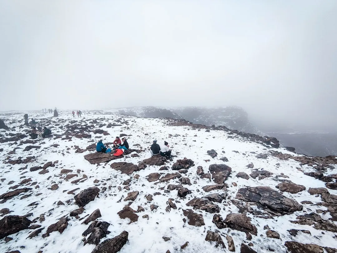
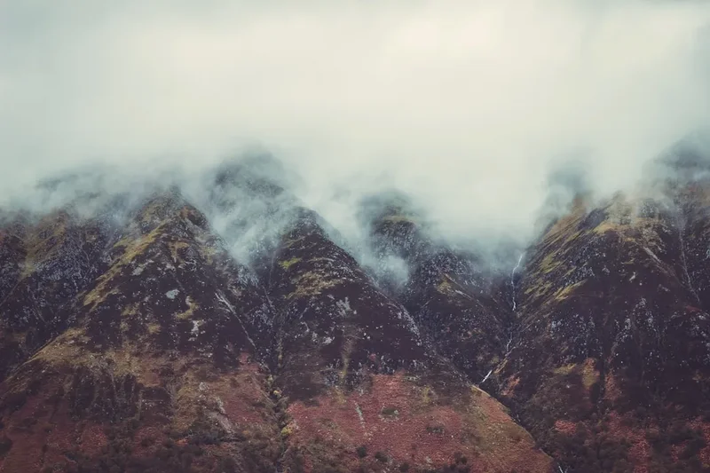
The final section is the summit plateau, a vast, boulder-strewn expanse that feels detached from the world below. This area is frequently shrouded in mist, with the summit being clear on average only 60 days per year. The plateau is home to the ruins of the old observatory, a survival shelter, and several large cairns. The sheer cliffs of the North Face drop away just metres from the summit cairn, providing a dizzying perspective on the mountain's geological might. This is a landscape defined by its extremes; even in mid-summer, temperatures at the top can be 10 degrees Celsius lower than in Fort William, with wind speeds often exceeding 50 kilometres per hour. The Mountain Track is not merely a walk; it is an encounter with the raw, unyielding character of the Scottish Highlands.
History and Cultural Context
The name "Ben Nevis" is derived from the Scottish Gaelic "Beinn Nibheis." While "Beinn" translates to mountain, "Nibheis" is more debated, often interpreted as "venomous" or "terrible," perhaps reflecting the mountain's fierce weather, or "the mountain with its head in the clouds." For centuries, the mountain was a formidable barrier, known only to local shepherds and the occasional intrepid explorer. The first recorded ascent was made in 1771 by James Wright, a botanist from Edinburgh, but it wasn't until the late 19th century that the mountain became a focal point for scientific and recreational interest.
The defining era for the Mountain Track began in 1883 with the construction of the Ben Nevis Observatory. At a time when high-altitude meteorology was in its infancy, the Scottish Meteorological Society raised funds to build a permanent station on the summit. To transport building materials and daily supplies, a path was constructed—the very same path hikers use today. For twenty years, a team of "weather men" lived year-round on the summit, recording hourly observations in some of the most brutal conditions imaginable. One notable figure was Clement Wragge, known as "Inclement Wragge," who climbed the mountain daily before the observatory was built to take readings. The observatory closed in 1904 due to a lack of government funding, but its ruins remain a haunting reminder of this period of scientific heroism.
Culturally, Ben Nevis holds a central place in Scottish identity. It is the climax of the West Highland Way and the ultimate peak in the "Three Peaks Challenge." Since 1895, it has also hosted the Ben Nevis Race, a gruelling athletic feat where runners charge from Fort William to the summit and back. The current record stands at an incredible 1 hour, 25 minutes, and 34 seconds—a stark contrast to the 7 to 9 hours taken by the average hiker. The mountain is also a site of remembrance, with various memorials on the plateau, and it remains a sacred landscape for those who appreciate the rugged solitude of the Highlands.
Want more background? Read extended notes on history and cultural context → Learn more
Seasonal Highlights and Weather Reality
The experience of Ben Nevis changes fundamentally with the seasons. In the summer months (June to August), the days are exceptionally long, with twilight lingering until nearly midnight. This provides a wide safety margin for hikers. However, this is also the busiest time, and the track can feel crowded. The "Ben Nevis midge"—a tiny biting insect—can be a nuisance on the lower, sheltered slopes during humid, still days.
Spring (May) and Autumn (September to October) are often considered the best times to visit. The air is crisper, the light is more dramatic for photography, and the crowds are thinner. In May, you will almost certainly encounter large snow patches on the upper plateau, which require care to cross. In October, the first dustings of winter snow begin to appear, and the daylight hours shorten rapidly, requiring an earlier start.
Winter (November to April) transforms Ben Nevis into a serious mountaineering proposition. The Mountain Track becomes buried under deep snow and ice, and the "Zig-zags" can become a dangerous slide. During this time, the path is often invisible, and the summit plateau becomes a featureless white void where navigation is impossible without a compass and the ability to follow strict bearings. Temperatures can drop to -20 degrees Celsius with wind chill, and avalanches are a genuine risk in the gullies. Winter ascents should only be attempted by those with ice axes, crampons, and the knowledge of how to use them. For the average hiker, the mountain is a summer-only destination.
Recommended Itinerary
Ben Nevis Mountain Track Route Progression
Stage 1: Glen Nevis to the Halfway Lochan
- Distance: 3.5 km
- Elevation gain: 570 m
- Time: 1.5–2 hours
- Start at the Glen Nevis Visitor Centre (20 m above sea level)
- Cross the bridge over the River Nevis and follow the well-marked path
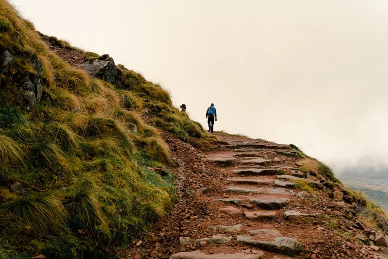
- The track climbs steeply via stone steps through open hillside
- Pass the junction where the path from the Ben Nevis Inn joins the main track
- Enjoy views back down into Glen Nevis and across to the Mamores range
- Arrive at the plateau containing Lochan Meall an t-Suidhe
- This stage is the "warm-up," though the steepness can be a shock to the system
Stage 2: The Halfway Lochan to the Top of the Zig-zags
- Distance: 3 km
- Elevation gain: 500 m
- Time: 1.5–2 hours
- The path skirts the eastern side of the lochan, offering a brief flat section
- Cross the Red Burn stream (a good spot to check water levels, though treatment is advised)
- Begin the "Zig-zags"—eight long traverses that gain height steadily
- The terrain shifts from grass and heather to grey scree and broken rock
- As you rise, the views of the North Face and the CMD Arête begin to open up to the north
- The path is wide and well-maintained but requires steady footwork on loose stones
Stage 3: The Summit Plateau and the Peak
- Distance: 2 km
- Elevation gain: 275 m
- Time: 1 hour
- The gradient eases as you emerge onto the vast summit plateau
- Follow the line of large stone cairns (essential for navigation in mist)
- Pass the "Gardyloo Gully" on your left—a sheer drop where observatory waste was once thrown
- Reach the summit cairn (1,345 m), the highest point in the UK
- Explore the ruins of the 1883 observatory and the emergency shelter
- On a clear day, identify the peaks of Glencoe to the south and the Cuillins of Skye to the northwest
- Take extreme care near the northern edge; the cliffs are vertical and often corniced with snow
Stage 4: The Descent
- Distance: 8.5 km
- Elevation loss: 1,352 m
- Time: 2.5–4 hours
- Retrace your steps carefully across the plateau
- In mist, use a compass to follow the bearing 231 degrees for 150 metres, then 282 degrees to avoid the gullies
- The descent of the Zig-zags is often harder on the knees than the ascent
- Take time at the Red Burn to rest before the final steep drop to the glen
- Finish back at the Visitor Centre or the Ben Nevis Inn for a well-earned refreshment
Important Notes:
- The descent often takes longer than expected due to leg fatigue
- Weather can change mid-hike; always be prepared to turn back
- The summit is often 9 degrees Celsius colder than the start point
- Mobile signal is intermittent and should not be relied upon for navigation
Planning and Bookings
Book Your Trip
Everything you need to plan your journey
Accommodation
Find places to stay near Fort William
Flights
Search flights to Fort William
Essential Preparation
Preparation for Ben Nevis begins with physical conditioning. While the track is a walk, it is a relentless uphill slog that tests cardiovascular fitness and leg strength. Hikers should be comfortable walking for 7 to 8 hours on uneven terrain. Beyond fitness, timing is crucial. Most hikers base themselves in Fort William, known as the "Outdoor Capital of the UK." This town provides all necessary amenities, including supermarkets, outdoor gear shops, and a wide range of accommodation. It is highly recommended to arrive in Fort William at least one day before your climb to check the latest mountain weather forecasts at the Glen Nevis Visitor Centre.
Logistically, no bookings are required to walk the mountain itself, as Scotland's "Right to Roam" laws allow public access. However, if you are travelling during the peak summer months or during a bank holiday weekend, accommodation in Fort William and Glen Nevis must be booked months in advance. Transport to the trailhead is straightforward; a local bus runs from Fort William to Glen Nevis, or it is a 30-minute walk from the town centre. If driving, the Visitor Centre car park fills up very early (often by 8:00 AM in summer), so an early start is essential.
Trail Accommodation
The Ben Nevis Mountain Track is strictly a day hike. There are no huts, lodges, or managed shelters on the mountain where you can stay overnight. The emergency shelter on the summit is for life-threatening situations only and is not a place for a planned overnight stay.
Nearby Options:
- Glen Nevis Youth Hostel: Located directly across from the start of the path. Offers dormitory and private rooms. Highly popular with hikers.
- Glen Nevis Caravan & Camping Park: A large, well-equipped site at the foot of the mountain with pitches for tents, motorhomes, and pods.
- Ben Nevis Inn & Bunkhouse: Situated at the very start of the "Achintee" path. Offers a bunkhouse and excellent food.
- Fort William Hotels/B&Bs: A vast array of options ranging from budget hostels to high-end hotels like the Alexandra or the Nevis Bank Inn.
Facilities: The Glen Nevis Visitor Centre at the trailhead provides toilets, a small shop, and information displays. Once you leave the Visitor Centre, there are no toilets or facilities of any kind on the mountain. You must be entirely self-sufficient.
Required Gear
- Hiking Boots: Sturdy, waterproof boots with good ankle support and a "Vibram" or similar high-grip sole. The terrain is rocky and often wet.
- Waterproof Layers: A high-quality waterproof jacket and overtrousers (Gore-Tex or similar). Scottish rain is often horizontal and persistent.
- Warm Clothing: A layering system including a moisture-wicking base layer, a fleece or wool mid-layer, and a lightweight insulated jacket. Avoid cotton, which stays cold when wet.
- Navigation: A physical Ordnance Survey map (Landranger 41 or Explorer 392) and a high-quality baseplate compass. Knowledge of how to take a bearing is essential for the summit plateau.
- Head Torch: Even if you plan to be down by daylight, delays happen. Bring a torch with spare batteries.
- First Aid Kit: Including blister plasters, antiseptic wipes, and any personal medication.
- Whistle: For emergency signalling (six blasts per minute).
What to Bring
- Water: At least 2–3 litres per person. While there are streams (like the Red Burn), they can run dry in summer or be contaminated by livestock/wildlife. A filtration bottle is a good investment.
- High-Energy Food: Pack a substantial lunch plus plenty of snacks (nuts, chocolate, energy bars). You will burn significantly more calories than on a flat walk.
- Sun Protection: Sunscreen, sunglasses, and a hat. The UV levels are much higher at the summit, and the wind can mask the heat of the sun.
- Warm Accessories: Even in summer, bring a warm hat and waterproof gloves. The summit temperature can be near freezing.
- Mobile Phone: Fully charged, with the "OS Maps" app or similar for offline use, but kept in a waterproof case.
- Emergency Survival Bag: A lightweight orange poly-bag or a foil bivvy bag to retain heat if you are forced to stop.
Permits
One of the great appeals of hiking in Scotland is the Land Reform (Scotland) Act 2003, which provides a statutory right of responsible access to most land and water. This means that no permits, fees, or registrations are required to hike the Ben Nevis Mountain Track. You do not need to "sign in" anywhere, although it is always wise to leave your intended route and estimated return time with someone at your accommodation.
Parking and Fees:
- Glen Nevis Visitor Centre Car Park: There is a daily charge for parking (currently approximately £8.00 for cars). The machines accept cards and coins. The revenue supports the maintenance of the track and the Visitor Centre.
- Braveheart Car Park: Located slightly further down the glen, this is often used as an overflow and may have different charging structures.
- Organised Groups: If you are leading a large charity event or a commercial group (typically 10+ people), you are encouraged to register with the Glen Nevis Visitor Centre to ensure the mountain isn't over-capacity and to receive safety briefings.
Access Restrictions: While access is generally open, hikers are asked to respect the "Scottish Outdoor Access Code." This includes keeping dogs under close control (especially during lambing season in the lower glens) and avoiding interference with any land management activities. During the Ben Nevis Race (usually the first Saturday in September), the track is extremely busy with runners, and hikers are advised to choose a different day or be prepared to step aside frequently.
Other Activities in the Area
Fort William and the surrounding Lochaber region offer a wealth of activities for those with extra time or for days when the mountain weather is too poor for an ascent:
- Steall Falls and Nevis Gorge: A spectacular, relatively flat walk further up Glen Nevis. It leads through a dramatic gorge to the second-highest waterfall in Scotland. The wire bridge crossing to the base of the falls is a local highlight.
- The Jacobite Steam Train: Famously known as the "Hogwarts Express," this train runs from Fort William to Mallaig, crossing the iconic Glenfinnan Viaduct. It is widely considered one of the most scenic rail journeys in the world.
- Neptune’s Staircase: A series of eight locks on the Caledonian Canal in Banavie. It is the longest staircase lock in Britain and offers a fascinating look at 19th-century engineering with views back toward Ben Nevis.
- West Highland Museum: Located in the centre of Fort William, this museum offers excellent exhibits on Jacobite history, local archaeology, and the history of the Ben Nevis Observatory.
- Mountain Biking at Nevis Range: Just north of Fort William, the Nevis Range offers world-class downhill and cross-country mountain bike trails, including the venue for the UCI Mountain Bike World Cup.
- Ben Nevis Distillery: One of the oldest licensed distilleries in Scotland, located at the base of the mountain. It offers tours and tastings for those looking to sample a "dram" of local whisky.
Safety and Conditions
The "Five Finger Gully" Trap: The most significant danger on Ben Nevis is navigational error on the summit plateau in poor visibility. Many hikers, when descending in mist, inadvertently veer too far south and end up in Five Finger Gully. This is a steep, loose, and highly dangerous area that has been the site of numerous fatalities. To avoid this, hikers must follow a strict compass bearing from the summit: walk 150 metres on a grid bearing of 231 degrees, then change to a grid bearing of 282 degrees to safely reach the top of the Zig-zags.
Weather Volatility: The weather on Ben Nevis can change from sunshine to a blizzard in less than 30 minutes. The mountain creates its own microclimate. Always check the Mountain Weather Information Service (MWIS) or the Met Office mountain forecast specifically for "Ben Nevis" before starting. If the forecast predicts winds over 50 km/h or heavy rain/snow, consider staying in the glen. Hypothermia is a real risk, even in summer, if you become wet and exhausted in high winds.
Mountain Rescue: In the event of an emergency, dial 999 or 112 and ask for "Police" and then "Mountain Rescue." The Lochaber Mountain Rescue Team is a volunteer organisation that performs incredible work, but they should only be called in genuine emergencies. Do not rely on them as a "taxi service" for exhaustion. Carrying a Personal Locator Beacon (PLB) is a good safety measure for solo hikers.
Physical Limits: The descent is where most injuries occur. Tired legs lead to trips and twisted ankles on the rocky path. Ensure you have saved enough energy and water for the three-hour walk back down. If you feel you are struggling to reach the Halfway Lochan within two hours, it is often a sign that you should turn back rather than pushing for the summit.
Side Trips and Points of Interest
Lochan Meall an t-Suidhe (The Halfway Lochan): This beautiful body of water sits in a saddle between Ben Nevis and the smaller peak of Meall an t-Suidhe. It is a perfect spot for a break and offers a different perspective on the mountain. The water is often still, reflecting the surrounding peaks, and the area is home to hardy alpine plants. A short walk around the lochan's edge provides views down into the Great Glen.
The CMD Arête: For experienced hikers looking for a more challenging route, the Carn Mor Dearg (CMD) Arête is a magnificent alternative. It involves climbing the neighbouring peak of Carn Mor Dearg and then traversing a narrow, rocky ridge that curves around to the summit of Ben Nevis. This route offers the best views of the North Face cliffs but requires a good head for heights and basic scrambling skills. It adds significantly to the time and effort of the day.
The Old Observatory Ruins: Spend some time exploring the stone foundations on the summit. You can still see the layout of the rooms where the meteorologists lived. Near the ruins is the "Peace Cairn," and the emergency shelter, which is built into the ruins of the observatory's tower. These structures are a poignant link to the mountain's history of human endurance.
The North Face Viewpoints: From the upper Zig-zags, you can look across the massive Coire Leis to the North Face. This is one of the most impressive mountain walls in Europe, featuring famous climbing routes like "The Orion Face" and "Tower Ridge." Even if you aren't a climber, the scale of these 600-metre cliffs is breathtaking.
Leave No Trace
With over 150,000 visitors a year, the impact on Ben Nevis is significant. The mountain is managed by several organisations, including the John Muir Trust, who work tirelessly to repair the path and protect the fragile environment. As a hiker, you have a responsibility to minimise your footprint.
Your responsibility as a walker:
- Pack it in, pack it out: This includes all litter, fruit peels, and nut shells. Banana skins and orange peels can take years to decompose in the cold, acidic environment of the summit.
- Human Waste: There are no toilets on the mountain. If you must go, do so at least 30 metres from any water source and bury it deep. Better yet, use a "Poo Bag" (available at the Visitor Centre) to carry out your waste. This is becoming a standard requirement on high-traffic mountains to prevent soil contamination.
- Stay on the Path: The "Zig-zags" are prone to erosion. Taking shortcuts between the bends destroys the vegetation and causes the soil to wash away during heavy rain, leading to dangerous "scarring" of the mountain.
- Respect the Wildlife: Do not feed the birds or any other animals. Highland cows in the lower glen should be given plenty of space, especially if they have calves.
- No Wild Camping on the Track: While wild camping is legal in Scotland, camping on or near the Mountain Track is discouraged due to the high volume of people and the lack of waste facilities. Use the official campsites in Glen Nevis.
- Stone Cairns: Do not build new cairns or move stones. The existing cairns are vital navigational aids; adding "decorative" cairns can confuse hikers in the mist and lead them into danger.