Beinn Eighe Mountain Trail - A Highland Gem
The Beinn Eighe Mountain Trail, nestled within the dramatic landscapes of Torridon in the Scottish Highlands, offers a challenging yet immensely rewarding day hike. This route ascends to the summit plateau of Beinn Eighe, the highest mountain in the Torridon range, providing breathtaking panoramic views across a vast expanse of rugged glens, shimmering lochs, and ancient mountains. The trail is renowned for its diverse terrain, from the initial ascent through Caledonian pine forest to the exposed, rocky summit ridge, and its unique geological features, including the internationally significant Triple Buttress. It's a journey that tests endurance, rewards with unparalleled vistas, and offers a profound connection to the wild heart of Scotland.
- Distance: 6.5 km one-way
- Elevation gain: 550 m
- Duration: 3–4 hours
- Difficulty: Challenging
- Best time to hike: April–October
- Closest town: Kinlochewe
- Trailhead access: Parking available at the Beinn Eighe National Nature Reserve visitor centre. Nearest airport: Inverness (INV), approximately 1.5 hours drive. Follow A835 to A832 towards Kinlochewe. Road conditions are generally good but can be affected by winter weather.
- Permits: No permits are required for this hike.
- Highest point: 993 m (Beinn Eighe summit)
Overview
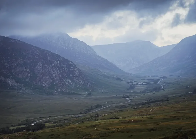
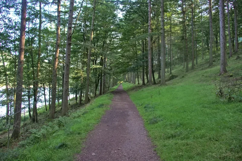
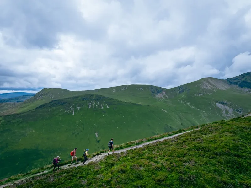
The Beinn Eighe Mountain Trail is a classic Scottish mountain walk, celebrated for its accessibility to a significant peak and its spectacular scenery. The route begins with a well-maintained path that winds through the ancient Caledonian pine forest of the Coire Mhic Fhearchair, a woodland that feels like stepping back in time. As the trail climbs, the trees thin, giving way to open moorland and then the rugged, rocky slopes characteristic of the Scottish Highlands. The ascent is steady but demanding, with sections of steep scree and rock requiring careful footing.
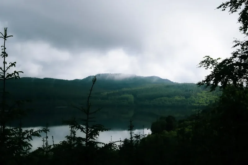
The highlight of the hike is reaching the summit plateau of Beinn Eighe. This expansive, undulating area offers a true sense of wildness and isolation. From here, the views are simply magnificent. To the north, the imposing peaks of Liathach and Slioch dominate the skyline. To the south and east, the landscape unfolds into a tapestry of lochs, including Loch Maree, and the vast wilderness of Wester Ross. The trail continues across the plateau to the trig point at 993 metres, marking the highest point of the mountain.
A significant geological feature along the route is the Triple Buttress, a series of three massive rock formations that are a testament to the mountain's glacial past. The trail passes close to these impressive structures, offering a unique opportunity to appreciate the raw power of nature and the forces that shaped this landscape. The descent follows a similar path, though care must be taken on the loose scree sections, especially when tired.
This trail is suitable for experienced hillwalkers with a good level of fitness and competence in mountain navigation. The weather in the Highlands can change rapidly, so preparation is key. Despite its challenging nature, the Beinn Eighe Mountain Trail offers an unforgettable experience, showcasing the dramatic beauty and wild spirit of Scotland.
History and Geological Significance
Beinn Eighe, meaning "Mountain of the File" in Gaelic, has a long and rich history, intertwined with the geology and human settlement of the Torridon region. For centuries, this mountain and its surrounding glens have been home to Gaelic-speaking communities, their lives shaped by the harsh but beautiful environment. The area was historically part of the vast estates of Clan MacLeod and later the Earls of Seaforth, with evidence of ancient settlements and shielings (summer pastures) scattered throughout the glens.
Geologically, Beinn Eighe is a site of international importance. It is composed primarily of Torridonian sandstone, a Precambrian rock formation dating back over 800 million years. The mountain's dramatic features, including the Triple Buttress, are the result of intense glaciation during the last Ice Age. As glaciers carved their way through the landscape, they sculpted the mountain's steep corries and sharp ridges. The summit plateau itself is a remnant of an ancient peneplain, a once-flat surface that has been uplifted and dissected by erosion.
The Beinn Eighe National Nature Reserve, established in 1951, was the first of its kind in Britain. Its designation aimed to protect the unique flora and fauna, including the remnants of the ancient Caledonian pine forest, and the exceptional geological features. The mountain trail itself was developed to allow visitors to experience this remarkable environment while minimising impact. The reserve also plays a crucial role in scientific research, studying the effects of climate change on fragile mountain ecosystems and the regeneration of the Caledonian forest.
The area's remoteness and ruggedness have also made it a place of refuge and inspiration. For centuries, it has attracted climbers, naturalists, and artists drawn to its wild beauty and challenging terrain. The Beinn Eighe Mountain Trail provides a direct connection to this deep history, allowing walkers to tread the same ground that has been shaped by geological forces and human endeavour for millennia.
Seasonal Highlights and Weather Considerations
The Beinn Eighe Mountain Trail is best enjoyed during the warmer months, from April to October, when daylight hours are longer and the risk of severe winter conditions is lower. However, even during summer, the Scottish Highlands are known for their unpredictable weather.
Spring (April–May): The landscape begins to awaken. Lower slopes may still hold patches of snow, and the Caledonian pine forest is a vibrant green. Days are lengthening, offering more time for hiking. However, early spring can still bring cold snaps, wind, and rain. The higher sections of the trail may remain snow-covered until late spring.
Summer (June–August): This is the most popular time to visit. Days are at their longest, and the weather is generally at its mildest, though heatwaves are rare. The mountain flora is in bloom, and the views can be spectacular on clear days. However, summer also brings the highest numbers of midges (tiny biting insects), which can be a significant nuisance, especially in sheltered, damp areas and during dawn and dusk. Sandflies are not a major issue here, but midges are.
Autumn (September–October): The colours of the landscape transform into stunning shades of gold, russet, and red. The air is often crisp and clear, offering excellent visibility. The midges usually disappear with the cooler temperatures. However, daylight hours shorten, and the risk of early snow and more severe weather increases as winter approaches. The mountain can become very exposed and cold.
Winter (November–March): The Beinn Eighe Mountain Trail is generally not recommended for casual hikers during winter. The mountain is often covered in snow and ice, requiring specialist winter mountaineering skills, equipment (ice axe, crampons), and navigation expertise. Conditions can be extremely hazardous, with high winds, blizzards, and avalanche risk. Only experienced winter mountaineers should consider attempting the route during this period.
Weather Reality: Regardless of the season, always be prepared for rapid changes. Wind, rain, and mist can descend quickly, significantly reducing visibility and making the exposed summit plateau treacherous. Hypothermia is a real risk, even in summer, due to wind chill and wet conditions. Check the mountain forecast (MetService) before you set out and be prepared to turn back if conditions deteriorate.
Recommended Itinerary
Beinn Eighe Mountain Trail - Day Hike Itinerary
Early Morning (Approx. 08:00 - 09:00): Arrival and Preparation
- Arrive at the Beinn Eighe National Nature Reserve visitor centre car park.
- Check weather conditions and mountain forecast (MetService).
- Ensure all gear is packed and ready.
- Use the visitor centre facilities if needed.
- Briefly study the trail map and understand the route.
Morning (Approx. 09:00 - 12:00): Ascent through Caledonian Forest and Moorland
- Start the hike from the car park, following the well-marked path into the ancient Caledonian pine forest.
- The initial section is a gentle, well-maintained path, gradually ascending through the trees.
- Observe the unique flora and fauna of this rare woodland ecosystem.
- The path begins to steepen as you leave the forest behind and enter open moorland.
- Continue ascending, with increasingly impressive views opening up towards Loch Maree and the surrounding mountains.
- The terrain becomes rougher, with loose stones and uneven ground.
Midday (Approx. 12:00 - 13:00): Reaching the Summit Plateau and Triple Buttress
- The trail becomes steeper and more rugged as you approach the base of the mountain's upper slopes.
- You will pass close to the impressive Triple Buttress, a series of massive rock formations. Take time to admire these geological wonders.
- The path continues to climb, often on scree and rocky sections, requiring careful footing.
- Reach the summit plateau of Beinn Eighe.
- Navigate across the plateau towards the trig point.
- Enjoy the expansive 360-degree panoramic views.
Afternoon (Approx. 13:00 - 15:00): Summit and Descent
- Reach the summit trig point (993 m). Take photographs and enjoy the achievement.
- Spend time appreciating the vastness of the Torridon landscape.
- Begin the descent, retracing your steps carefully, particularly on the scree slopes.
- Pay close attention to your footing to avoid slips and falls.
- As you descend, the views of the surrounding glens and lochs will change.
Late Afternoon (Approx. 15:00 - 16:00): Return to Trailhead
- Continue descending through the moorland and back into the Caledonian pine forest.
- The path becomes easier underfoot as you approach the car park.
- Arrive back at the Beinn Eighe National Nature Reserve visitor centre car park.
- Ensure you have accounted for all your belongings and leave no trace.
Important Notes:
- This is a challenging mountain hike. Good fitness and mountain walking experience are essential.
- Navigation skills are crucial, especially in poor visibility. Carry a map and compass and know how to use them.
- The weather can change very rapidly. Always check the mountain forecast before setting out and be prepared for all conditions.
- Wear sturdy, waterproof hiking boots and bring waterproof clothing (jacket and trousers).
- Carry sufficient food and water for the duration of the hike.
- Midges can be a problem during summer months; bring effective insect repellent.
- Be aware of the terrain; sections are steep and rocky, with loose scree.
Planning and Bookings
Book Your Trip
Everything you need to plan your journey
Accommodation
Find places to stay near Kinlochewe
Flights
Search flights to Kinlochewe
Essential Preparation
The Beinn Eighe Mountain Trail is a demanding day hike that requires careful planning. Given its location in the Scottish Highlands, weather is the most significant factor influencing the success and safety of your trip. Always check the mountain forecast from a reliable source like MetService specifically for the Torridon area or Beinn Eighe. Ensure you have a good level of physical fitness; the 550 metres of elevation gain over a relatively short distance means the ascent is steep and sustained. Good quality, broken-in hiking boots with ankle support are essential due to the rocky and uneven terrain. A waterproof and windproof outer layer is non-negotiable, as conditions can change dramatically and rapidly. Familiarise yourself with the route using a map and compass, and consider downloading an offline map to your phone as a backup. The nearest significant town with amenities is Kinlochewe, which offers basic services. For a wider range of accommodation, shops, and transport links, Inverness is the closest major city, approximately 1.5 hours drive away.
Trail Accommodation
This is a day hike requiring no overnight accommodation. Walkers typically base themselves in nearby villages such as Kinlochewe, Gairloch, or Shieldaig, or travel from further afield, such as Inverness. Accommodation options in these areas range from small guesthouses and bed and breakfasts to self-catering cottages and campsites. Booking accommodation in advance is highly recommended, especially during the peak summer season (June to August) and around public holidays.
Required Gear
- Footwear: Sturdy, waterproof hiking boots with good ankle support. Ensure they are well broken-in to prevent blisters.
- Clothing:
- Waterproof and windproof jacket (Gore-Tex or similar) with a hood.
- Waterproof and windproof overtrousers.
- Warm layers: fleece jacket or jumper, thermal base layers (merino wool or synthetic). Avoid cotton.
- Hat: warm hat (beanie) for cold weather and sun hat for sunny days.
- Gloves: warm, waterproof gloves.
- Navigation:
- Map of the Beinn Eighe area (e.g., Ordnance Survey Landranger or Explorer series).
- Compass.
- GPS device or smartphone with offline mapping app (e.g., OS Maps, ViewRanger) and fully charged battery.
- Safety:
- First-aid kit: including blister plasters, pain relievers, antiseptic wipes, bandages, and any personal medication.
- Head torch with spare batteries (essential in case of unexpected delays or poor visibility).
- Emergency shelter: lightweight bivvy bag or emergency blanket.
- Whistle.
- Other:
- Backpack (30-40 litre capacity) with a rain cover.
- Trekking poles (optional but recommended for steep ascents and descents).
What to Bring
- Food: High-energy snacks (e.g., nuts, dried fruit, energy bars), sandwiches or a packed lunch. Ensure you have enough for the planned duration plus a little extra in case of delays.
- Water: At least 1.5–2 litres of water per person. There are no reliable water sources on the upper mountain that can be safely drunk without treatment.
- Water treatment: Water filter or purification tablets if you intend to refill from lower streams (not recommended on the upper mountain).
- Toiletries: Small pack of toilet paper, hand sanitiser, any personal hygiene items.
- Sun protection: Sunscreen (SPF 30+), sunglasses.
- Insect repellent: Effective midge repellent (containing DEET or Picaridin) is essential during summer months.
- Mobile phone: Fully charged, for emergencies. Note that mobile signal can be intermittent in the Highlands.
- Camera: To capture the stunning scenery.
- Small amount of cash: For any unexpected needs.
Permits
No permits are required to hike the Beinn Eighe Mountain Trail. This is a public right-of-way and part of the Beinn Eighe National Nature Reserve, managed by NatureScot. Access is free and open to all, provided visitors adhere to the principles of responsible outdoor access as outlined in the Scottish Outdoor Access Code.
While no booking or permit is necessary, it is still crucial to plan your visit, especially regarding timing and safety. The trail can be busy during peak season (summer weekends and holidays), so starting early is advisable to avoid crowds and ensure you have ample daylight for your hike. Always check the weather forecast before you leave home and again at the trailhead if possible. The Beinn Eighe visitor centre can sometimes provide up-to-date information on local conditions.
Other Activities in the Area
The Torridon region and its surroundings offer a wealth of activities for outdoor enthusiasts and nature lovers:
- Hiking and Hillwalking: Beinn Eighe is just one of many spectacular mountains in the area. Other popular hikes include Liathach (a more technical and exposed ridge walk), Slioch (offering superb views over Loch Maree), and the coastal paths around Gairloch.
- Loch Maree: This is one of Scotland's most beautiful lochs, with its many islands and dramatic mountain backdrop. Boat trips are available, offering a different perspective on the landscape. Kayaking and canoeing are also popular activities.
- Beinn Eighe National Nature Reserve Visitor Centre: Located at the trailhead, this centre provides excellent information about the geology, flora, and fauna of the reserve, as well as details on the ancient Caledonian pine forest.
- Gairloch: A charming coastal village with sandy beaches, a harbour, and the unique Gairloch Heritage Museum. It's also a popular spot for whale and dolphin watching tours.
- Shieldaig: A picturesque village on the shores of Loch Torridon, known for its distinctive island with a single Scots pine tree.
- Torridon Countryside Centre: Offers insights into the natural and cultural heritage of the Torridon area.
- Photography: The dramatic landscapes, ancient forests, and rugged coastlines make this region a paradise for photographers.
- Wildlife Spotting: Keep an eye out for red deer, golden eagles, pine martens, and various seabirds.
Safety and Conditions
Weather: The most critical safety consideration for the Beinn Eighe Mountain Trail is the weather. Highland weather is notoriously unpredictable and can change from calm and sunny to gale-force winds, heavy rain, and thick mist within minutes. Always check the MetService mountain forecast for the Torridon area before you set out. Be prepared for all conditions, even in summer.
Navigation: While the main path is generally well-defined, especially in the lower sections, the summit plateau can be disorienting in poor visibility. Carry a map and compass and know how to use them. A GPS device or smartphone with an offline map app is a valuable backup, but do not rely on electronics alone.
Terrain: The trail involves steep ascents and descents, with sections of loose scree and rocky ground. Good quality, sturdy hiking boots are essential for ankle support and grip. Take your time, especially on descents, and be mindful of where you place your feet to avoid slips and falls.
Hypothermia: This is a significant risk in the Scottish Highlands, even in summer. Being wet and exposed to wind can rapidly lower your body temperature. Wear layers of non-cotton clothing that can be added or removed as needed. Ensure you have a waterproof and windproof outer layer and a warm hat and gloves.
Midges: During the summer months (typically June to September), midges can be a considerable nuisance. These tiny biting insects are most active at dawn and dusk, and in damp, sheltered conditions. Carry a good quality midge repellent (containing DEET or Picaridin) and consider wearing a head net.
Emergency: In case of an emergency, dial 999 or 112 and ask for Police, then Mountain Rescue. Provide your location as accurately as possible. It is advisable to carry a fully charged mobile phone, though signal can be intermittent.
Scottish Outdoor Access Code: Familiarise yourself with the principles of the Scottish Outdoor Access Code to ensure you are responsible and respectful of the environment and local communities.
Side Trips and Points of Interest
The Triple Buttress: A prominent geological feature on the ascent to Beinn Eighe's summit plateau. These three massive rock formations are a striking example of glacial erosion and are a key landmark on the trail. They offer excellent photographic opportunities and a chance to appreciate the mountain's ancient geological history.
Summit Plateau Views: The expansive summit plateau itself is a point of interest. Unlike many mountains with a single, sharp peak, Beinn Eighe has a broad, undulating summit area. From here, on a clear day, the views are exceptional, encompassing Loch Maree, the distinctive shape of Slioch, the imposing ridge of Liathach, and the vast wilderness of Wester Ross stretching towards the Atlantic coast.
Caledonian Pine Forest: The initial section of the trail winds through a remnant of the ancient Caledonian pine forest. This unique ecosystem, with its gnarled Scots pines, heather, and diverse undergrowth, offers a stark contrast to the open mountain terrain above. It's a chance to experience a rare and precious habitat.
Visitor Centre Information: The Beinn Eighe National Nature Reserve visitor centre at the trailhead provides valuable context about the mountain's geology, ecology, and history. It's worth spending a few minutes here before or after your hike to enhance your understanding of the landscape.
Leave No Trace
The Beinn Eighe Mountain Trail traverses a sensitive and beautiful natural environment. Adhering to Leave No Trace principles is essential to preserve its wild character and ecological integrity for future visitors and for the benefit of the wildlife that inhabits it.
Plan Ahead and Prepare: Research the trail, understand its challenges, and check the weather forecast. Pack appropriate gear and sufficient food and water. Be aware of the Scottish Outdoor Access Code.
Travel and Camp on Durable Surfaces: Stick to the marked path. The vegetation on the mountain slopes, especially the fragile mosses and lichens, can take a very long time to recover if trampled. Avoid creating new paths or cutting across switchbacks.
Dispose of Waste Properly: Pack out everything you pack in. This includes all litter, food scraps, and wrappers. There are no bins on the mountain. Use the facilities at the visitor centre for any waste disposal.
Leave What You Find: Do not disturb or remove any natural objects, such as rocks, plants, or fungi. Take only photographs and memories.
Minimise Campfire Impacts: As this is a day hike, campfires are not applicable. However, if you were to camp in the wider area, always use a stove and avoid open fires, especially in or near woodland.
Respect Wildlife: Observe wildlife from a distance. Do not feed any animals, as this can harm their health and alter their natural behaviour. Be particularly mindful of ground-nesting birds during the breeding season.
Be Considerate of Other Visitors: Keep noise levels down, especially on the summit. Yield to other walkers where appropriate, particularly on narrow sections of the path. Respect the peaceful nature of the mountain environment.