Beartooth High Lakes Trail - A Journey Across the Roof of the Rockies
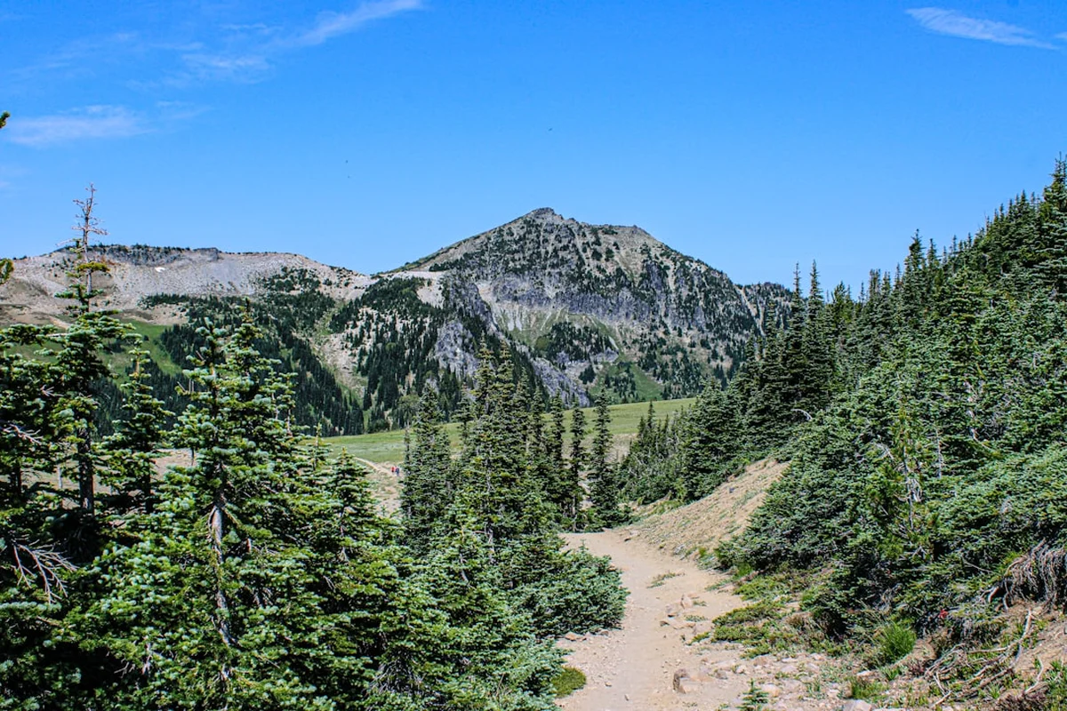
The Beartooth High Lakes Trail is a premier alpine trekking experience located within the Shoshone National Forest and the Absaroka-Beartooth Wilderness of Wyoming and Montana. This 17.7-kilometre route offers hikers an unparalleled opportunity to traverse one of the highest and most rugged plateaus in North America. Characterised by its vast, treeless expanses, crystalline alpine lakes, and jagged granite peaks, the trail provides a "top of the world" sensation that is rarely matched in the lower 48 states of the USA. Starting at an elevation of approximately 2,900 metres, the trail weaves through a landscape shaped by ancient glaciers and extreme weather, offering a glimpse into a fragile tundra ecosystem that remains snow-covered for the majority of the year.
Unlike many mountain trails that require a long, arduous climb through dense forest to reach the alpine zone, the Beartooth High Lakes Trail begins already at the timberline. This unique geography is thanks to the Beartooth Highway (US-212), a National Scenic Byways All-American Road that deposits adventurers directly onto the high plateau. From the moment you step away from the trailhead at Island Lake, you are immersed in a high-altitude wilderness where the sky feels immense and the horizon is dominated by the 3,000-metre summits of the Beartooth Range. This is a landscape of stark beauty, where hardy wildflowers bloom in the brief summer window and the silence is broken only by the whistle of a marmot or the wind whipping across the water.
- Distance: 17.7 km (round trip/loop options)
- Duration: 6–8 hours
- Elevation Gain: 457 m
- Difficulty: Moderate (due to altitude and terrain)
- Highest Point: Approximately 3,100 m
- Best Time: July to September
- Closest City: Red Lodge, Montana
Overview
The Beartooth High Lakes Trail is often described as a "lake-hopping" adventure. The route is not a single, steep ascent to a summit, but rather a rolling traverse across a high-altitude bench that sits nestled beneath the towering Beartooth Crest. The trail connects a series of spectacular alpine basins, each holding one or more lakes of startling clarity. From the deep blues of Island Lake and Night Lake to the turquoise hues of Beauty Lake and Crane Lake, the water serves as a constant focal point against the grey granite and green tundra. The terrain is a mix of well-defined dirt paths, rocky sections, and occasional marshy areas where snowmelt lingers late into the season.
The geological story of this area is as dramatic as its scenery. The Beartooth Mountains are composed of some of the oldest rocks on Earth—Archean crystalline basement rocks that date back nearly four billion years. These ancient granites and gneisses were uplifted millions of years ago and subsequently sculpted by massive ice sheets during the last glacial period. The result is a "paternoster" lake system, where a series of glacial lakes are connected by a single stream, resembling the beads of a rosary. Walking this trail is a lesson in glaciology, as you pass through U-shaped valleys, cirques, and moraines that tell the story of the ice that once dominated this plateau.
For the modern hiker, the Beartooth High Lakes Trail offers a sense of isolation and wilderness that is increasingly hard to find. While the trailhead is accessible by road, the vastness of the Absaroka-Beartooth Wilderness—spanning nearly 382,000 hectares—means that once you are a few kilometres into the backcountry, the sounds of civilisation vanish. The trail is a favourite for photographers, who come to capture the reflection of Beartooth Butte in the still morning waters, and for naturalists, who seek out the unique flora and fauna adapted to this harsh environment. Whether you are looking for a challenging day hike or a gentle introduction to high-altitude trekking, this trail provides a quintessential Rocky Mountain experience.
History and Cultural Context
The human history of the Beartooth Plateau is as layered as its geology. For thousands of years, the area was the seasonal home and hunting grounds of Indigenous peoples, most notably the Apsáalooke (Crow) Nation. The mountains provided a source of spiritual power and a place for vision quests, as well as a rich hunting ground for bighorn sheep and elk during the summer months. The name "Beartooth" itself is a translation of the Crow word "Na Piet Say," referring to a jagged peak that resembles the canine tooth of a grizzly bear. To the Apsáalooke, these mountains were not just a physical barrier but a sacred landscape deeply entwined with their cultural identity and survival.
European exploration of the region began in the early 19th century with fur trappers and mountain men, but the ruggedness of the plateau kept it largely inaccessible to large-scale settlement. It wasn't until the late 1800s and early 1900s that miners began to explore the area for gold and silver, though the Beartooth High Lakes region remained relatively untouched compared to the nearby Cooke City area. The most significant change to the region came in the 1930s with the construction of the Beartooth Highway. Built as a public works project during the Great Depression, the road was hailed as a "triumph of engineering," snaking its way up nearly 1,500 vertical metres to provide access to the high country. This road transformed the plateau from a remote wilderness into a world-class destination for outdoor recreation.
In 1978, the United States Congress officially designated the Absaroka-Beartooth Wilderness, ensuring that the land surrounding the High Lakes Trail would remain protected from development, motorised vehicles, and commercial exploitation. This designation preserves the primitive character of the trail, allowing hikers to experience the landscape much as the Apsáalooke did centuries ago. Today, the trail is managed by the United States Forest Service, which works to balance the high volume of summer visitors with the need to protect the fragile alpine tundra and the wildlife that calls this high-altitude sanctuary home.
Want more background? Read extended notes on history and cultural context → Learn more
Seasonal Highlights and Weather Reality
The Beartooth High Lakes Trail is defined by its extremely short hiking season. Due to its high elevation, the plateau is buried under several metres of snow for nine months of the year. The "summer" window typically opens in early July and closes by late September, though snowstorms can occur in any month of the year. Understanding the seasonal nuances is critical for a safe and enjoyable trek.
July: The Season of Water and Wildflowers
July is a month of transition. As the snowpack melts, the plateau erupts in a vibrant display of alpine wildflowers. Hikers can expect to see Indian Paintbrush, Alpine Forget-Me-Nots, and Moss Campion carpeting the tundra. However, this is also the wettest time of year. The trail can be extremely muddy, and stream crossings may be high and fast. Mosquitoes are also at their peak in July, thriving in the standing water left by the melting snow. Hikers should be prepared for boggy conditions and bring plenty of insect repellent.
August: The Golden Window
August is generally considered the best time to hike the Beartooth High Lakes Trail. The snow has mostly receded, the trails have dried out, and the mosquito population begins to dwindle. The weather is typically stable, with warm, sunny days and cool nights. This is the ideal time for photography, as the lakes are clear and the visibility is at its peak. However, August also brings the risk of afternoon thunderstorms. These storms can develop rapidly and are often accompanied by dangerous lightning, making the exposed plateau a hazardous place to be after midday.
September: The Crisp Descent into Autumn
September brings a dramatic change to the plateau. The air becomes crisp, and the tundra turns from green to brilliant shades of gold and red. The crowds of summer disappear, offering a more solitary experience. While the days are beautiful, the nights can drop well below freezing, and the first significant snowfalls of the season often arrive by mid-month. Hikers in September must be prepared for winter-like conditions and shorter daylight hours. By the end of the month, the Beartooth Highway often closes for the season, cutting off access to the trailhead until the following summer.
Recommended Itinerary
Beartooth High Lakes Day Hike Itinerary
Early Morning: Departure and Trailhead Arrival
- 07:00 – Depart Red Lodge, Montana, for the 45-minute drive up the Beartooth Highway.
- 07:45 – Arrive at the Island Lake Trailhead (elevation 2,900 m).
- 08:00 – Begin the hike. The trail starts with a gentle descent toward the shores of Island Lake.
- Enjoy the early morning light reflecting off the water and the surrounding granite peaks.
- Cross the outlet of Island Lake via a sturdy bridge or rock hop, depending on water levels.
Mid-Morning: The Traverse to Night Lake
- 09:00 – Reach the junction for Night Lake. The trail climbs gently through subalpine fir and whitebark pine.
- Distance covered: ~3.5 km.
- Pass through open meadows where marmots and pikas are frequently seen among the talus slopes.
- 09:45 – Arrive at the shores of Night Lake. This is an excellent spot for a short break and to admire the views of the Beartooth Crest to the west.
- The trail continues along the eastern shore of Night Lake, offering flat and easy walking.
Midday: Beauty Lake and the High Point
- 11:00 – Begin the moderate climb toward Beauty Lake. This section contains the bulk of the day's elevation gain.
- 11:45 – Arrive at Beauty Lake (elevation 3,050 m). This is arguably the most scenic lake on the route.
- Distance covered: ~8 km.
- Find a flat granite slab along the shore for a well-earned lunch.
- Observe the dramatic cliffs that drop directly into the turquoise water.
- Keep an eye on the sky; if clouds are building, prepare to begin your return journey to avoid afternoon lightning.
Afternoon: Return via Crane Lake or Retrace Steps
- 13:00 – Begin the return journey. You can retrace your steps for a simpler navigation or take the fork toward Crane Lake for a slightly different perspective.
- 14:30 – Pass back through the meadows near Night Lake. The afternoon light often highlights the "krummholz" (stunted, wind-blown trees) that define the timberline.
- 16:00 – Final ascent back to the Island Lake Trailhead. This last kilometre can feel strenuous as you climb back up to the road.
- 16:30 – Arrive back at the vehicle. Total distance: 17.7 km.
- Drive back down the Beartooth Highway, stopping at the scenic overlooks for a final view of the plateau.
Important Notes:
- The itinerary is based on a moderate pace of 2.5–3 km per hour, including breaks.
- Altitude affects everyone differently; allow extra time if you are coming from sea level.
- Water is abundant along the trail, but all water must be treated before drinking.
- The trail is well-marked with cairns in rocky sections, but a map is essential.
- Always check the weather forecast at the Top of the World Store before starting.
Planning and Bookings
Book Your Trip
Everything you need to plan your journey
Accommodation
Find places to stay near Red Lodge
Flights
Search flights to Red Lodge
Essential Preparation
Preparation for the Beartooth High Lakes Trail begins with understanding the physical demands of high-altitude hiking. Even though the elevation gain is moderate (457 m), the entire hike takes place above 2,900 metres. At this altitude, the air is significantly thinner, and physical exertion feels much more taxing. It is highly recommended that hikers spend at least one or two nights in Red Lodge (1,697 m) or at a high-altitude campground before attempting the full trail to allow their bodies to acclimatise. Dehydration and altitude sickness are the most common issues faced by visitors.
Logistically, the trail is straightforward as it does not require advanced bookings or permits for day use. However, transport coordination is key. The Beartooth Highway is a winding, high-mountain road that can be intimidating for some drivers. Ensure your vehicle is in good working order, with plenty of fuel, as there are no services between Red Lodge and the Top of the World Store (which has limited hours and supplies). If you are travelling from further afield, Billings Logan International Airport (BIL) is the nearest major transport hub, located approximately 2.5 hours from the trailhead.
Trail Accommodation
This is a day hike requiring no overnight accommodation on the trail itself. However, there are several options for staying near the trailhead to facilitate an early start.
Campgrounds:
- Island Lake Campground: Located directly at the trailhead. It offers basic sites with fire rings and picnic tables. It is a first-come, first-served site and fills up very quickly in July and August. Facilities include vault toilets and seasonal potable water.
- Beartooth Lake Campground: Located a few kilometres down the road. Similar facilities to Island Lake, situated on the shores of Beartooth Lake.
- Dispersed Camping: Allowed in certain areas of the Shoshone National Forest, but strict regulations apply regarding distance from water sources and roads.
Lodging:
- Red Lodge, Montana: A full-service mountain town with numerous hotels, motels, and bed-and-breakfasts. It serves as the primary base for most hikers.
- Cooke City, Montana: Located at the other end of the Beartooth Highway, offering a smaller selection of rustic cabins and motels.
- Top of the World Store: Offers a very limited number of basic motel rooms located about 10 minutes from the trailhead.
Required Gear
- Hiking Boots: Sturdy, waterproof boots with good ankle support are essential. The trail involves rocky sections and potential mud or snow crossings.
- Waterproof Jacket: A high-quality, breathable waterproof shell (Gore-Tex or similar) is mandatory. Weather on the plateau can change from sun to freezing rain in minutes.
- Insulating Layers: A fleece or lightweight down jacket. Even in August, temperatures can drop rapidly if the sun goes behind a cloud or the wind picks up.
- Navigation: A physical topographic map and a compass, or a GPS device with offline maps. While the trail is generally clear, fog can reduce visibility to a few metres.
- Sun Protection: High-SPF sunscreen, lip balm with SPF, and polarised sunglasses. The UV radiation at 3,000 metres is extremely intense.
- Backpack: A 20–30 litre daypack with a rain cover to keep your gear dry during sudden storms.
- Emergency Whistle: Often built into backpack chest straps, essential for signalling in low visibility.
What to Bring
- Water: At least 2–3 litres per person. While there is plenty of water in the lakes, it must be treated.
- Water Treatment: A lightweight filter (like a Sawyer Squeeze) or chemical purification tablets to treat lake water.
- Food: High-energy snacks (nuts, dried fruit, energy bars) and a substantial lunch. You will burn more calories than usual due to the altitude and cold.
- Bear Spray: This is grizzly bear country. Every hiker should carry bear spray in an accessible holster (not inside the pack) and know how to use it.
- First Aid Kit: Including blister plasters (moleskin), antiseptic wipes, ibuprofen, and any personal medications.
- Headlamp: With spare batteries, in case your hike takes longer than expected and you are caught out after dark.
- Insect Repellent: Essential for July and early August to combat the aggressive alpine mosquitoes.
- Trowel and Toilet Paper: For "answering the call of nature" when away from trailhead facilities (ensure you follow LNT principles).
Permits
For day hikers, no formal permits or fees are required to access the Beartooth High Lakes Trail. This makes it one of the most accessible high-wilderness experiences in the United States. However, there are several regulations and "soft" permit requirements that visitors must be aware of to ensure the continued protection of the Absaroka-Beartooth Wilderness.
Self-Registration: At the Island Lake Trailhead, there is typically a self-registration kiosk. While not a "permit" in the legal sense, the Forest Service uses this data to track trail usage and justify funding for maintenance. It also provides a record of who is on the trail in the event of an emergency. It is highly recommended that all groups sign in and out.
Group Size Limits: To preserve the wilderness character and minimise impact on the fragile tundra, group sizes are strictly limited. In the Absaroka-Beartooth Wilderness, the maximum group size is 15 people. If you are travelling with a larger organised group, you must split into smaller units and maintain a significant distance between groups on the trail.
Overnight Permits: If you decide to turn your day hike into an overnight backpacking trip, different rules apply. While no fee-based permit is required for most of the Shoshone National Forest side, you must still follow all wilderness regulations, including specific campfire bans (no fires allowed above 3,000 metres or within 200 metres of lakes). If your route crosses into the Custer Gallatin National Forest or Yellowstone National Park, specific backcountry permits and fees will apply.
Commercial Use: Any organised group that is charging a fee for the hike (such as a guided tour or a photography workshop) must obtain a Special Use Permit from the Forest Service well in advance. Unauthorised commercial activity is strictly prohibited and subject to heavy fines.
Other Activities in the Area
The Beartooth Plateau and the surrounding towns offer a wealth of activities for those looking to extend their stay in this spectacular corner of the Rockies:
- Drive the Beartooth Highway: Often called "the most beautiful drive in America," this 110-kilometre stretch of US-212 reaches a height of 3,336 metres at Beartooth Pass. There are numerous pull-outs with interpretive signs explaining the geology and history of the area.
- Explore Red Lodge: This historic mining town is now a vibrant outdoor hub. Visit the Carbon County Historical Society and Museum, enjoy local craft beer at the Red Lodge Ales Brewing Company, or browse the many independent galleries and outdoor shops.
- Yellowstone National Park: The Northeast Entrance to Yellowstone is located just past Cooke City, about an hour's drive from the High Lakes trailhead. This entrance provides access to the Lamar Valley, famous for its wolf and grizzly bear sightings.
- Fishing: The alpine lakes along the trail are home to brook trout and the rare Yellowstone cutthroat trout. A valid Wyoming or Montana fishing licence is required, depending on exactly where you cast your line.
- Wildlife Viewing: Beyond the trail, the plateau is home to mountain goats, which can often be seen on the steep cliffs near Beartooth Pass. Early morning or late evening are the best times for sightings.
- Winter Sports: While the trail is a summer destination, the Beartooth Basin Summer Ski Area (located near the pass) often stays open for skiing and snowboarding well into July, offering a unique summer-snow experience.
Safety and Conditions
Weather Hazards: The single greatest danger on the Beartooth High Lakes Trail is the weather. At 3,000 metres, the atmosphere is thin and provides little protection from the elements. Afternoon thunderstorms are a near-daily occurrence in mid-summer. Because the trail is almost entirely above the timberline, there is no cover from lightning. The standard safety protocol is to be off the high plateau and heading back toward the trailhead or lower elevations by 14:00. If you see "towering cumulus" clouds (clouds that look like cauliflower) building in the morning, reconsider your turnaround time.
Grizzly Bear Safety: The Absaroka-Beartooth Wilderness is prime grizzly bear habitat. Unlike black bears, grizzlies can be more aggressive if surprised, especially if a sow is with cubs. Safety measures include:
- Making noise while walking (talking, singing, or clapping) to avoid surprising a bear.
- Carrying bear spray in an accessible location and knowing how to use it.
- Hiking in groups of three or more.
- Never leaving food or scented items unattended.
- If you see a bear, do not run. Back away slowly and give the animal plenty of space.
Altitude and Hydration: Acute Mountain Sickness (AMS) can affect anyone, regardless of fitness level. Symptoms include headache, nausea, dizziness, and fatigue. The best prevention is to stay hydrated and ascend slowly. Drink more water than you think you need, as the dry mountain air and increased respiration lead to rapid fluid loss. If symptoms of AMS become severe, the only cure is to descend to a lower elevation immediately.
Navigation and Terrain: While the trail is generally well-maintained, it can be obscured by late-season snow patches or washed out by heavy rain. In the rocky sections, look for "cairns" (small stacks of rocks) that mark the route. Do not rely solely on a mobile phone for navigation, as battery life is significantly reduced in cold temperatures and there is no cellular service on the plateau. Always carry a physical map and compass as a backup.
Emergency Services: There is no mobile phone reception on the trail. In the event of a serious injury, someone in your party will need to hike out to the trailhead to summon help, or you must use a satellite communication device (like a Garmin inReach). Search and rescue operations in this remote area are complex and can take many hours to initiate.
Side Trips and Points of Interest
Beartooth Butte: This massive, flat-topped mountain is a geological anomaly. While most of the Beartooth Range is composed of ancient Archean rock, the Butte is capped with much younger sedimentary layers (Devonian and Ordovician). It serves as a stunning backdrop for photos from the shores of Beauty Lake or Beartooth Lake. For the very adventurous, there are non-technical scramble routes to the summit, though these are not part of the official High Lakes Trail.
The "Top of the World": Located a short drive from the trailhead, the Top of the World Store is a historic landmark. It is one of the most isolated stores in the lower 48 states. It’s a great place to stop for a post-hike ice cream, to check the latest weather updates, or to buy a souvenir. The store has been operating since the highway opened and captures the rugged spirit of the plateau.
Hidden Falls: Between Night Lake and Beauty Lake, there are several unnamed cascades where the outlet streams drop over granite benches. These "hidden falls" are particularly spectacular in July during the peak of the snowmelt. Taking a few minutes to step off the main trail (carefully, on durable surfaces) to find these cascades offers a peaceful alternative to the more popular lake shores.
The Beartooth Pass Overlook: While not on the trail itself, no trip to the High Lakes is complete without driving the extra 10 minutes to the top of Beartooth Pass (3,336 m). From the overlook, you can see across the entire plateau you just hiked, with views extending all the way to the Absaroka Range in Yellowstone and the Wind River Range to the south.
Leave No Trace
The alpine tundra is one of the most fragile ecosystems on Earth. Plants here may only have a few weeks of growing season each year, and a single footstep can destroy decades of growth. Because the Beartooth High Lakes Trail is so accessible, it is under constant pressure from high visitor numbers. Following Leave No Trace (LNT) principles is not just a suggestion; it is essential for the survival of this wilderness.
Key LNT Practices for the Beartooth Plateau:
- Travel on Durable Surfaces: Stay on the established trail at all times. If you must step off the trail to let others pass, try to step on rocks or gravel rather than the soft tundra grass or wildflowers.
- Dispose of Waste Properly: Pack out everything you pack in, including orange peels, nut shells, and tissues. If you need to urinate, do so on rocks or bare soil to avoid attracting wildlife with the salt in your urine. For solid waste, use the vault toilets at the trailhead. If caught on the trail, dig a "cathole" 15–20 cm deep at least 60 metres from any water source, and pack out your toilet paper.
- Leave What You Find: Do not pick wildflowers, and do not remove rocks or fossils. Leave the landscape exactly as you found it for the next hiker to enjoy.
- Minimise Campfire Impacts: Campfires are strictly prohibited in the alpine zone. They scar the ground and consume the very limited amount of dead wood that provides habitat for small mammals and insects. Use a lightweight stove for any cooking.
- Respect Wildlife: Observe animals from a distance. Never feed marmots, pikas, or birds, as this habituates them to humans and can lead to their death.
- Be Considerate of Others: Keep noise levels low. The sound of a Bluetooth speaker carries a long way in the thin mountain air and ruins the wilderness experience for others. Yield to uphill hikers and keep your group size small.