Bay of Fires Walk - Tasmania's Coastal Masterpiece
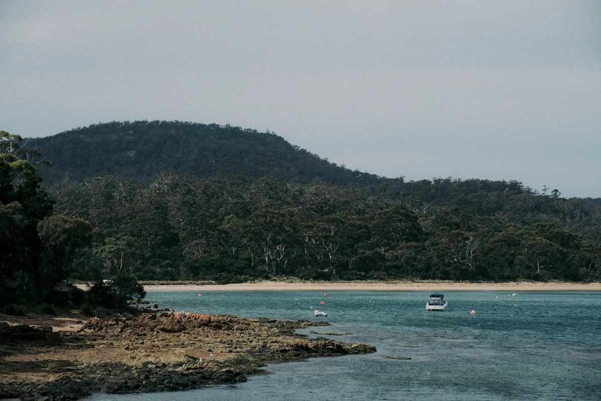
The Bay of Fires Walk is one of Australia's most visually arresting coastal journeys—a 34.0 km four-day expedition along the northeastern edge of Tasmania. Stretching from the remote northern reaches of Mount William National Park down to the pristine inlet of The Gardens, this walk traverses a landscape defined by a startling colour palette: brilliant white quartz sands, turquoise waters of the Tasman Sea, and the iconic granite boulders cloaked in fiery orange lichen that give the region its name. Unlike the rugged, mountainous interior of the island, the Bay of Fires offers a rhythmic, meditative experience where the sound of the swell and the cry of the sea eagle provide the soundtrack to your progress. It is a journey through a transition zone where the coastal heathland meets the sea, offering a profound sense of isolation and a connection to an ancient coastline that has remained largely unchanged for millennia.
- Distance: 34.0 km one-way
- Duration: 4 days / 3 nights
- Season: October–May (shoulder seasons offer the best balance of weather and solitude)
- Accommodation: National Park campsites (Deep Creek, Anson's Bay, Eddystone Point)
- Highest point: Coastal dunes and headlands (approx. 40 m)
- Daily walkers: Unrestricted for independent walkers, though campsites have limited capacity
- Direction: North to south (Stumpys Bay to The Gardens)
Overview
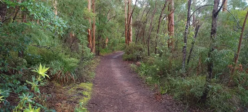
The Bay of Fires is not merely a hiking trail; it is a sensory immersion into one of the world's most beautiful coastal environments. Consistently ranked among the top beach destinations globally, the region offers a walking experience that prioritises landscape aesthetics and ecological intimacy over sheer physical exertion. The route is characterised by its accessibility, with a total elevation gain of only 200 metres, making it an ideal choice for those seeking a multi-day adventure without the punishing vertical climbs found on the Overland Track or the Three Capes Track. However, the ease of the gradient is balanced by the unique challenge of beach walking—navigating soft sands, timing river crossings with the tides, and enduring the exposure of a coastline that faces the full fetch of the Tasman Sea.
The defining feature of the walk is the granite geology. The coastline is littered with massive boulders that appear to be glowing. This phenomenon is caused by a specific type of lichen (from the family Teloschistaceae) that thrives in the salt-spray zone. When the sun hits these rocks against the backdrop of the crystal-clear water, the visual contrast is nothing short of spectacular. The walk is divided into distinct phases: the remote, wild northern section within Mount William National Park; the crossing of the Anson's Bay inlet; the historic landmark of Eddystone Point (Larapuna); and the final, iconic stretch through the Bay of Fires Conservation Area. Each day reveals a different facet of the Tasmanian coast, from secluded lagoons and hidden sea caves to vast, sweeping arcs of sand where your footprints are the only signs of human presence.
Wildlife encounters are a hallmark of the Bay of Fires experience. The region is a stronghold for the Forester kangaroo, Tasmania's largest marsupial, which can often be seen grazing on the coastal grasses at dawn and dusk. In the skies, white-bellied sea eagles and wedge-tailed eagles patrol the thermals, while the shoreline is home to the endangered hooded plover, which nests directly on the sand. During the migration seasons (September to November and May to July), walkers may even spot humpback or southern right whales breaching offshore. This is a landscape that feels alive, vibrant, and remarkably pristine, offering a rare opportunity to disconnect from the modern world and recalibrate to the slow, steady pulse of the ocean.
History and Cultural Context
The Bay of Fires holds deep spiritual and historical significance for the Palawa (Tasmanian Aboriginal) people. For thousands of years, the North East nation utilised this coastline as a rich source of food and a vital travel corridor. The evidence of this long occupation is visible today in the form of extensive shell middens—ancient mounds of discarded shells, bones, and stone tools—that are found along the dunes and headlands. These sites are not merely archaeological relics; they are sacred connections to ancestors and a testament to the sustainable management of the land by the traditional owners. The Palawa name for the Eddystone Point area is Larapuna, and the region remains a focal point for contemporary Aboriginal community activities and land management.
The European name "Bay of Fires" was bestowed in 1773 by Captain Tobias Furneaux, commander of the HMS Adventure, during James Cook's second voyage to the Pacific. As Furneaux sailed past the coast, he observed numerous fires burning along the shoreline. These were the campfires of the Palawa people, whose presence was so pervasive that the entire horizon seemed to be alight. While Furneaux's naming was a literal observation of human activity, it has since taken on a double meaning, often associated with the fiery orange lichen that coats the rocks. In the 19th century, the region became a site of maritime importance, leading to the construction of the Eddystone Point Lighthouse in 1889. Built from local pink granite, the lighthouse was a critical navigational aid for ships navigating the treacherous waters of the Bass Strait and the Tasman Sea.
In more recent history, the Bay of Fires became a centre for conservation efforts. In the 1970s and 80s, the ecological value of the region was formally recognised with the expansion of Mount William National Park and the creation of the Bay of Fires Conservation Area. These protections were designed to safeguard the unique coastal heathlands and the diverse birdlife from the pressures of development. Today, the walk represents a successful balance between tourism and preservation, allowing visitors to experience the majesty of the coast while ensuring that its cultural and natural heritage remains intact for future generations.
Want more background? Read extended notes on history and cultural context → Learn more
Seasonal Highlights and Weather Reality
Tasmania's weather is famously temperamental, and the Bay of Fires is no exception. While the region generally enjoys a milder climate than the mountainous west, it is still subject to rapid changes and the influence of the "Roaring Forties" winds. Choosing the right season is essential for a comfortable and safe journey.
Summer (December to February) is the most popular time for the walk. The days are long, with twilight lasting until nearly 9:00 PM, and the temperatures are ideal for swimming in the sheltered lagoons. Average daytime temperatures range from 20°C to 25°C, though heatwaves can occasionally push the mercury above 30°C. This is also the best time for spotting marine life, but it is the busiest season, and campsites can be crowded. Sun protection is critical, as the UV index in Tasmania is exceptionally high, and the reflection off the white sand intensifies the exposure.
Autumn (March to May) is considered by many locals to be the "golden window" for the Bay of Fires. The winds tend to drop, the sea remains relatively warm from the summer sun, and the light takes on a soft, photographic quality that makes the orange rocks glow even more intensely. The crowds thin out significantly, providing a greater sense of solitude. However, the nights begin to cool down, and walkers should be prepared for temperatures dropping toward 5°C after sunset.
Spring (September to November) brings a spectacular display of wildflowers to the coastal heathlands. The wattles, banksias, and native orchids erupt in colour, and the birdlife is at its most active. This is also a prime time for whale watching. The downside of spring is the wind; the region can experience strong northwesterly gales that make beach walking arduous and kick up significant sand. Rainfall is also more frequent during this period.
Winter (June to August) is for the hardy. While the Bay of Fires rarely sees snow, the wind-chill factor can be significant, and daytime temperatures often hover around 12°C. The advantage of a winter walk is the absolute isolation and the dramatic, moody skies that provide a different perspective on the landscape. Many of the river crossings can be deeper and faster-flowing after winter rains, requiring extra caution.
Recommended Itinerary
4-Day Bay of Fires Walk Itinerary
Day 1: Stumpys Bay to Deep Creek
- Distance: 9 km
- Elevation gain: 40 m
- Time: 3–4 hours
- Start at Stumpys Bay Number 4 campsite in Mount William National Park
- Walk south along the wide, firm sands of Stumpys Bay
- Navigate the first of many granite headlands, offering views back toward the Furneaux Group of islands
- Pass through coastal scrub where Forester kangaroos are frequently spotted
- Arrive at Deep Creek campsite, a sheltered spot nestled behind the primary dunes
- This shorter first day allows for travel time from Launceston and a gentle introduction to sand walking
Day 2: Deep Creek to Anson's Bay
- Distance: 10 km
- Elevation gain: 60 m
- Time: 4–5 hours
- Continue south along a series of secluded beaches and rocky points
- The orange lichen becomes more prominent as you move further south
- Explore the rock pools at low tide, home to colourful anemones and starfish
- Cross the coastal heathland sections to avoid impassable headlands at high tide
- Arrive at the northern end of Anson's Bay
- Note: The crossing of the Anson's Bay inlet requires careful timing with the tide or a pre-arranged boat transfer
- Camp at the designated sites near the Anson's Bay township or Policemans Point
Day 3: Anson's Bay to Eddystone Point (Larapuna)
- Distance: 7 km
- Elevation gain: 50 m
- Time: 3 hours
- A shorter day focused on the cultural and historical heart of the region
- Walk along the sweeping curve of the beach toward the prominent lighthouse
- Ascend the headland to the Eddystone Point Lighthouse (Larapuna)
- Spend time exploring the historic pink granite buildings and the Aboriginal heritage sites
- The views from the point are the most expansive of the entire walk, stretching north and south for kilometres
- Camp at the Eddystone Point camping area, which offers excellent sunset views over the hinterland
Day 4: Eddystone Point to The Gardens
- Distance: 8 km
- Elevation gain: 50 m
- Time: 3–4 hours
- The final stretch through the most iconic "Bay of Fires" scenery
- Walk through a labyrinth of giant orange-clad boulders and hidden white-sand coves
- Pass through the Bay of Fires Conservation Area, where the water is often at its most turquoise
- Final beach walk into The Gardens, a small coastal settlement and the official end of the trail
- Celebrate the completion of the journey with a swim in the protected waters of the inlet
- Pre-arranged transport picks up from the car park at The Gardens for the return to St Helens or Launceston
Important Notes:
- Tide charts are essential; some headlands are impassable at high tide
- Water is scarce; all water collected from creeks must be treated or filtered
- The Anson's Bay inlet crossing can be dangerous; do not attempt to swim across in heavy swell or outgoing tides
- Mobile reception is intermittent and should not be relied upon for navigation
- The walk is mostly flat, but walking on soft sand for 4 days is more tiring than it sounds
Planning and Bookings
Book Your Trip
Everything you need to plan your journey
Accommodation
Find places to stay near Launceston
Flights
Search flights to Launceston
Essential Preparation
The Bay of Fires Walk requires a high degree of self-sufficiency, particularly for independent walkers. Unlike the Great Walks of New Zealand, there is no central booking system for the trail itself, but you must manage your own logistics, transport, and park entries. The nearest major city is Launceston, which has an airport (LST) with regular flights from Melbourne, Sydney, and Brisbane. From Launceston, it is a 2.5-hour drive to the trailhead at Stumpys Bay. Most walkers choose to base themselves in the town of St Helens (the largest town on the East Coast) before or after the walk. St Helens offers supermarkets, outdoor stores, and a range of accommodation.
Fitness requirements are moderate. While the terrain is flat, the physical toll of walking on sand with a multi-day pack should not be underestimated. It is recommended to do several training walks on sand prior to the trip to condition your calves and ankles. Logistics coordination is the most complex part of the planning: you will need to arrange a vehicle drop-off at Stumpys Bay and a pick-up at The Gardens, or use a local shuttle service based in St Helens.
Trail Accommodation
Accommodation on the Bay of Fires Walk consists of National Park and Conservation Area campsites. There are no huts or permanent shelters on this route for independent walkers. (Note: Private guided walks operate in the area and use their own exclusive lodges, but these are not available to independent hikers).
Campsite Facilities:
- Designated clearing for tents (usually on grass or sand behind the dunes)
- Basic pit or composting toilets at major sites (Stumpys Bay, Deep Creek, Eddystone Point)
- No running water or taps (must collect from creeks or carry in)
- No cooking facilities or tables
- No rubbish bins (strict pack-in, pack-out policy)
- No electricity or lighting
Booking Requirements:
- Campsites are generally "first-come, first-served"
- No booking fee for the campsites themselves, but a valid Tasmania Parks Pass is mandatory for all walkers
- During peak summer periods (Christmas to late January), campsites can fill up early in the day
- Maximum stay limits apply (usually 4 weeks, though irrelevant for through-hikers)
- Camping is only permitted in designated areas to protect the fragile dune vegetation
Required Gear
- Hiking boots or sturdy trail shoes - lightweight and breathable are better for sand; ensure they are well-drained
- Sand gaiters - essential to keep sand and small shells out of your boots, which prevents blisters
- Lightweight tent - 3-season rated, must be able to withstand high winds and be pitched in sandy soil (sand pegs recommended)
- Sleeping bag - rated to 0°C to 5°C; even in summer, coastal winds can be chilly
- Sleeping mat - insulated mat for comfort on uneven ground
- Backpack - 50-65L with a high-quality harness and rain cover
- Tide clock or printed tide tables - non-negotiable for safe headland navigation
- Topographic map and compass - TASMAP 1:25,000 series (Eddystone and binalong sheets)
- Head torch - with spare batteries
- First aid kit - including heavy-duty blister kits (moleskin or Second Skin), antiseptic, and pressure bandages for snake bites
What to Bring
- Food for 4 days - lightweight, high-calorie dehydrated meals, plus plenty of snacks (no resupply points on trail)
- Water treatment - high-quality filter (like a Sawyer Squeeze or Katadyn BeFree) or purification tablets; creek water can be brackish or contain tannins
- Water storage - capacity to carry at least 3-4 litres per person, as some sections have no reliable water sources
- Stove and fuel - lightweight gas or liquid fuel stove (no fires permitted)
- Sun protection - SPF 50+ sunscreen, wide-brimmed hat, and high-quality sunglasses (polarized are best for water glare)
- Clothing layers - moisture-wicking base layers, a warm fleece or down jacket, and a high-quality waterproof shell
- Personal toiletries - biodegradable soap, trowel for waste (if away from toilets), and hand sanitiser
- Power bank - to keep phones/GPS charged for emergency use
- Dry bags - to keep clothes and sleeping bag dry during potential rain or deep river crossings
Permits
While the Bay of Fires Walk does not require a specific "hiking permit" or a limited-entry booking like the Overland Track, every visitor must possess a valid Tasmania Parks Pass. This pass grants entry to all of Tasmania's national parks, including Mount William National Park, where the walk begins. The revenue from these passes is directly reinvested into track maintenance, conservation programs, and the provision of visitor facilities.
Parks Pass Options:
- Daily Pass: Valid for up to 24 hours (not recommended for this 4-day walk).
- Holiday Pass: Valid for up to 2 months for a single vehicle or person. This is the most cost-effective option for most walkers. Cost: approx. AUD$40 per person or AUD$80 per vehicle.
- Annual Pass: For those planning multiple trips to Tasmania within a year.
How to Purchase:
- Online via the Tasmania Parks and Wildlife Service (PWS) website (recommended)
- At the PWS office in Launceston or the Visitor Information Centre in St Helens
- At self-service kiosks located at the entrance to major national parks (though Stumpys Bay may not have a reliable kiosk)
Important Compliance: You must display your pass on your vehicle dashboard if leaving a car at the trailhead, or carry a printed copy/digital version on your person if being dropped off. Rangers do patrol the campsites and trailheads, and fines apply for non-compliance. Additionally, if you are crossing the Anson's Bay inlet via a private boat transfer, ensure this is booked and paid for well in advance, as there is no "on-demand" service at the water's edge.
Other Activities in the Area
The North East coast of Tasmania is a hub for outdoor adventure and culinary experiences. Consider these additions to your itinerary:
- St Helens Mountain Bike Trails: Just a short drive from the end of the walk, St Helens is home to world-class mountain bike trails, including the "Bay of Fires" descent which runs from the mountains to the sea.
- Binalong Bay: The southern gateway to the Bay of Fires. It offers excellent swimming, surfing, and the famous "Skeleton Bay" lookout. It's a great place to relax for a day after your hike.
- Pyengana Dairy: Located inland from St Helens, this historic dairy produces some of Australia's finest cloth-bound cheddar. The farmhouse café is a perfect spot for a post-hike lunch.
- St Columba Falls: One of Tasmania's highest waterfalls, located in a lush rainforest setting about 45 minutes from St Helens. A gentle 20-minute walk leads to the base of the falls.
- Deep Sea Fishing: St Helens is known as the game fishing capital of Tasmania. Charters are available for those looking to catch tuna, marlin, or local reef fish.
- Wine Tasting: The Tamar Valley and East Coast wine regions are famous for cool-climate Pinot Noir and Chardonnay. Several excellent cellar doors are located within an hour's drive of the trail.
Safety and Conditions
Pre-Departure Checks:
- Check the Bureau of Meteorology (BOM) forecast for the "East Coast" district. Pay close attention to wind speed and direction.
- Consult the Tasmania Fire Service website for any active bushfire alerts or "Total Fire Ban" declarations, which are common in summer.
- Download the "BOM Weather" and "Emergency Plus" apps for real-time updates.
- Check the tide charts for Eddystone Point. Aim to cross headlands and inlets at low tide whenever possible.
Coastal Hazards: The primary risks on the Bay of Fires Walk are environmental. The sun is exceptionally strong; heatstroke and severe sunburn can occur even on overcast days. Dehydration is a constant risk due to the lack of reliable fresh water. The ocean itself is powerful; rogue waves can sweep over rock platforms, and rip currents are common on the open beaches. Never swim alone and avoid walking on wet rocks near the surf line. Snake safety is also paramount; the Lowland Copperhead and the Tiger Snake are common in the coastal heath. They are highly venomous but generally shy. Always wear gaiters, watch where you step, and carry a pressure immobilisation bandage.
Inlet Crossings: The crossing at Anson's Bay is the most significant technical challenge. At low tide, it may be possible to wade across, but the depth and current vary wildly depending on recent rainfall and sea conditions. If the water is above waist height or the current feels strong, do not attempt it. Many walkers choose to arrange a shuttle around the bay or a boat transfer to avoid this risk.
Remote Access: Much of the trail has no road access. In the event of an injury, evacuation can be difficult and expensive. Carrying a Personal Locator Beacon (PLB) is strongly recommended. Ensure you leave a detailed trip intent form with a reliable contact person who knows when to expect your return.
Side Trips and Points of Interest
Eddystone Point Lighthouse (Larapuna): This is the architectural highlight of the walk. Standing 35 metres tall, the lighthouse is constructed from blocks of pink granite quarried from the nearby cliffs. While the tower itself is usually closed to the public, the surrounding grounds and the historic keepers' cottages offer a fascinating glimpse into 19th-century maritime life. The area is also a significant cultural site for the Aboriginal community, with interpretive signage explaining the history of Larapuna.
The Blue Lagoon: Located near the northern end of the walk in Mount William National Park, this coastal lagoon is a haven for birdlife. It is a perfect spot for a midday break, offering calm, tea-coloured waters (stained by tannins from the surrounding vegetation) that contrast beautifully with the white sand dunes.
Skeleton Bay: Near the southern end of the walk, this bay features some of the most intricate rock formations on the coast. At low tide, you can explore sea caves and natural arches carved into the granite. It is a prime location for photography, especially during the "blue hour" before sunrise.
Mount William Summit: For those with extra energy on Day 1, a side trip to the summit of Mount William (216 m) provides a 360-degree view of the entire coastline you are about to walk. The track is well-marked and takes about 1.5 hours return from the inland road, though it requires a detour from the coastal route.
Leave No Trace
The Bay of Fires is a fragile ecosystem that faces increasing pressure from tourism. Adhering to Leave No Trace principles is essential to maintaining the "wilderness" character of the walk and protecting the habitat of endangered species.
Your responsibility as a walker:
- Respect Aboriginal Heritage: Do not touch, walk on, or remove items from shell middens. These are protected sites of immense cultural value. If you find a stone tool or artefact, leave it exactly where it is.
- Protect the Dunes: Always use designated access tracks to cross from the beach to the campsites. Walking over dunes destroys the grasses that prevent erosion and can crush the nests of shorebirds.
- Waste Management: Pack out all rubbish, including organic waste like orange peels and apple cores, which do not belong in this environment. Use the provided toilets at campsites. If you must go between sites, bury waste at least 15 cm deep and 100 m from water sources.
- Water Protection: Do not use soap or detergent directly in creeks or lagoons. Even biodegradable soap can harm aquatic life. Carry water 50 m away from the source for washing.
- Fire Safety: Use a fuel stove for all cooking. Campfires are generally prohibited in the National Park and Conservation Area due to the high risk of bushfires in the dry coastal heath.
- Wildlife: Observe animals from a distance. Never feed kangaroos or wallabies, as human food can cause "lumpy jaw" and other fatal diseases.