USA — Hammonton
Embark on the Batona Trail, an 86.1 km moderate trek through New Jersey's Pine Barrens wilderness. This point-to-point journey traverses Brendan T. Byrne, Wharton, and Bass River State Forests, immersing you in a unique landscape of pitch pine forests, Atlantic white cedar wetlands, and sugar sand terrain. Experience a diverse ecosystem and a serene, isolated walk unlike any other.
Distance: 86.1 km
Elevation Gain: 297 m
Difficulty: Moderate
Duration: 3-4 days
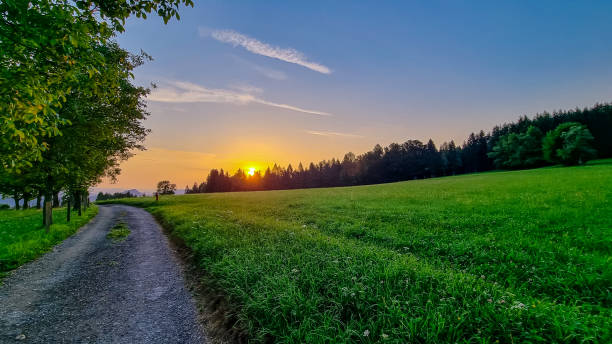
The Batona Trail is the premier long-distance hiking route in the Mid-Atlantic United States, offering an 86.1-kilometre point-to-point odyssey through the enigmatic and ecologically unique New Jersey Pine Barrens. Spanning three state forests—Brendan T. Byrne, Wharton, and Bass River—this trail provides a profound immersion into a landscape defined by pitch pines, Atlantic white cedar swamps, and the iconic "sugar sand" that characterises the region. Unlike the rugged, vertical challenges of the Appalachian Trail to the north, the Batona Trail offers a horizontal wilderness experience where the challenge lies in the endurance of soft-sand trekking and the subtle, haunting beauty of a forest that feels remarkably remote despite its proximity to major metropolitan centres. The name "Batona" is a portmanteau of "BAck TO NAture," a philosophy that remains at the core of the trail's identity more than sixty years after its inception.
The Batona Trail is a masterclass in subtle landscape transitions. As a point-to-point route, it carries walkers through the largest remaining tract of open space on the Mid-Atlantic seaboard, a region designated as a UNESCO International Biosphere Reserve. The trail's total elevation gain of just 297 metres over 86 kilometres might suggest an easy stroll, but the reality of the Pine Barrens is more complex. The "sugar sand"—a fine, white, silica-rich soil—acts like a treadmill on a low setting, requiring significantly more energy per kilometre than firm forest soil. This physical demand is balanced by the sensory rewards of the environment: the scent of pine resin on a warm afternoon, the tea-coloured "cedar water" of the tea-stained streams, and the absolute silence found in the depths of the Wharton State Forest.
The trail serves as a corridor through a "fire-climax" ecosystem, where the flora has evolved specifically to thrive in—and even depend upon—periodic forest fires. Walkers will observe the resilient pitch pines (Pinus rigida), which can sprout new needles directly from their trunks after a fire, and the dense, cool corridors of Atlantic white cedar swamps that provide a stark, emerald contrast to the dry upland pine forests. The Batona is not a trail of grand mountain vistas, but rather one of intimate details: the rare bog asphodel blooming in a hidden wetland, the tracks of a white-tailed deer in the fresh sand, or the sudden appearance of a historic "ghost town" like Batsto Village, where the ruins of the 18th-century iron industry still stand.
Logistically, the trail requires careful planning. Because it is a point-to-point route, hikers must arrange for a vehicle shuttle or use local transport services between the northern terminus at Ong's Hat and the southern terminus at Bass River State Forest. While the trail is well-marked with its signature pink blazes, the uniformity of the forest and the lack of significant topographical landmarks mean that navigation requires constant attention. This is a journey for those who appreciate the quiet, the ancient, and the understated—a true "back to nature" experience in one of America's most misunderstood wilderness areas.
The Batona Trail was born from the vision of the Batona Hiking Club of Philadelphia, specifically its founder, Dale Knapschaefer. In 1961, the club sought to create a continuous footpath that would connect the various state-owned lands within the New Jersey Pine Barrens, providing a sanctuary for hikers away from the encroaching suburban development of the mid-20th century. The trail was blazed entirely by volunteers, a tradition of stewardship that continues today through the efforts of the Batona Hiking Club and the New Jersey Department of Environmental Protection. The pink blazes that mark the route were chosen for their high visibility against the dark greens and greys of the pine forest.
The land through which the trail passes is steeped in a rich, often dark, folklore and industrial history. Long before it was a recreational corridor, the Pine Barrens were the centre of a massive bog iron industry during the American Revolutionary War. The "cedar water" rivers were dammed to power furnaces and forges, producing cannons and shot for the Continental Army. Towns like Batsto and Harrisville once bustled with thousands of workers before the discovery of coal in Pennsylvania rendered bog iron obsolete, leaving behind the "ghost towns" that hikers encounter today. The region is also the legendary home of the "Jersey Devil," a mythical creature said to inhabit the densest parts of the forest since 1735—a story that adds a layer of gothic mystery to the evening hours at camp.
Culturally, the area was historically populated by "Pineys"—independent-minded settlers who lived off the land by harvesting timber, moss, charcoal, and berries. In the early 20th century, Elizabeth White and Dr. Frederick Coville used the unique acidic soil of the Pine Barrens to develop the first cultivated highbush blueberry, an agricultural breakthrough that still defines the region's economy. Walking the Batona Trail is as much a journey through this human history of industry, isolation, and innovation as it is a natural exploration.
Want more background? Read extended notes on history and cultural context → Learn more
The Batona Trail is technically accessible year-round, but the experience varies dramatically with the seasons. Autumn (late September to early November) is widely considered the "golden window" for trekking. During this time, the humidity of the New Jersey summer breaks, the mosquitoes and "chiggers" (biting mites) subside, and the deciduous trees in the cedar swamps—particularly the red maples—provide a brilliant splash of colour against the evergreen pines. Daytime temperatures typically hover between 15°C and 20°C, making for ideal walking conditions.
Spring (April to May) offers another excellent window, characterised by the blooming of rare orchids and the emergence of the Pine Barrens tree frog. However, this is also the start of "tick season," which requires vigilant prevention. Summer (June to August) is the most challenging season. Temperatures frequently exceed 30°C with high humidity, and the sandy trail reflects heat, creating a "kiln effect." Furthermore, the Pine Barrens are notorious for their insect populations in summer; without heavy-duty repellent and head nets, the experience can be uncomfortable. Water sources also become less reliable during dry summer spells.
Winter (December to March) provides a stark, quiet beauty. Snow is common but rarely deep enough to require snowshoes for long periods. The primary challenge in winter is the damp cold; because the region is coastal, the air holds moisture that can make 2°C feel significantly colder. However, for the prepared hiker, winter offers the greatest solitude and the easiest navigation, as the undergrowth thins and the pink blazes stand out sharply against the grey trunks and white snow.
Day 1: Ong's Hat to Lower Forge
Day 2: Lower Forge to Batsto Village
Day 3: Batsto Village to Buttonwood Hill
Day 4: Buttonwood Hill to Bass River
Important Notes:
The Batona Trail requires more logistical coordination than a typical loop hike. Because it is a point-to-point route, the first step is deciding on your transport strategy. Most hikers leave a vehicle at the southern terminus (Bass River) and arrange a shuttle or ride-share to the northern terminus (Ong's Hat). Hammonton is the closest major town and serves as an excellent base for supplies, last-minute gear, and pre-hike accommodation. It is known as the "Blueberry Capital of the World" and has several motels and restaurants.
Physical preparation should focus on endurance rather than vertical gain. If possible, practice walking on soft sand or loose soil, as this uses different muscle groups than firm trails. Ensure you have a reliable offline navigation system, as the repetitive nature of the pine forest can lead to "trail hypnosis," where hikers miss turns at fire road crossings.
Accommodation on the Batona Trail consists exclusively of designated state forest campsites. Wild camping (stealth camping) is strictly prohibited to protect the fragile ecosystem and manage fire risk.
Campsite Facilities:
Booking Requirements:
There is no "permit" required to walk the Batona Trail itself; however, permits are mandatory for overnight stays at any of the state forest campsites. These must be secured in advance, as rangers do patrol the sites, especially in the Wharton State Forest section.
Booking Process:
Costs:
Group Permits: If travelling in a group of more than 10 people, special group site permits are required. These are located at specific areas like Bodine Field and must be booked well in advance.


Precisely traced GPX for the Batona Trail, ready for your GPS or favourite mapping app.
The Pine Barrens offer a wealth of experiences beyond the Batona Trail:
Ticks and Lyme Disease: This is the primary safety concern on the Batona Trail. The Pine Barrens are home to high concentrations of deer ticks and lone star ticks. Lyme disease is endemic to the region. Prevention is critical: use Permethrin on clothes, perform "tick checks" every evening, and seek medical advice if a "bullseye" rash or flu-like symptoms appear after the hike.
Water Management: While the trail crosses many streams, the water is highly acidic and laden with tannins. While not harmful, these tannins can clog some fine-pore filters more quickly than clear mountain water. Always carry at least 2–3 litres of water, especially in the summer when smaller tributaries may dry up.
Fire Risk: The Pine Barrens are one of the most fire-prone ecosystems in the world. During dry spells, campfires may be strictly prohibited. Always check the current fire "class" (Low to Extreme) at the state forest office before starting. Never leave a fire unattended and ensure it is "dead out" before sleeping or leaving.
Navigation: The trail is marked with pink blazes, but fire roads and logging tracks frequently intersect the route. It is easy to accidentally follow a well-worn fire road instead of the single-track trail. If you haven't seen a pink blaze in 200 metres, backtrack to the last known marker.
Heat Exhaustion: In July and August, the combination of soft sand and high humidity can lead to rapid dehydration and heat stroke. Start your days early (at dawn) and rest during the heat of the afternoon.
Apple Pie Hill: Located at the 33-kilometre mark (from the north), this is the highest point on the trail. While the "hill" itself is modest, the fire tower at the summit provides a spectacular vantage point. On a clear day, the skyline of Philadelphia is visible to the west and the casinos of Atlantic City to the southeast. It is the only place on the trail where you can truly appreciate the "sea of pines" that covers southern New Jersey.
Carranza Memorial: A secluded monument in the woods marking the spot where Captain Emilio Carranza, the "Lindbergh of Mexico," crashed during a goodwill flight in 1928. It is a somber and unexpected piece of international history in the middle of the wilderness. Every July, a memorial service is held here by members of the American Legion and the Mexican consulate.
The Pygmy Forest: Located near the southern end of the trail in the "Plains" section of Bass River State Forest. This is a globally rare ecosystem where mature pitch pines and oaks are stunted by extreme soil conditions and frequent fires, reaching only chest height. Walking through a "forest" where you can see over the treetops is a surreal experience.
Batsto Lake: A beautiful, dark-water lake created by the damming of the Batsto River. It offers excellent photography opportunities, especially at sunrise when mist rises from the cedar-stained water. The lake is a focal point for the historic village and provides a serene backdrop for the second night of the trek.
The Pine Barrens ecosystem is surprisingly fragile. The sandy soil is easily eroded, and the rare plants that live in the wetlands can be destroyed by a single misplaced footstep. Adhering to Leave No Trace principles is essential for the continued health of this UNESCO Biosphere Reserve.
Specific Batona Trail LNT Guidelines: