Barbados — Bridgetown
Baldwin Trail, Barbados: A moderate 8.0 km loop through St. Joseph's rugged Scotland District. This unique Barbados trail offers a dramatic departure from typical Caribbean scenery, traversing ancient sedimentary rocks and challenging terrain. Expect diverse landscapes and a rewarding 3-4 hour walk.
Distance: 8.0 km
Elevation Gain: 250 m
Difficulty: Moderate
Duration: 3-4 hours
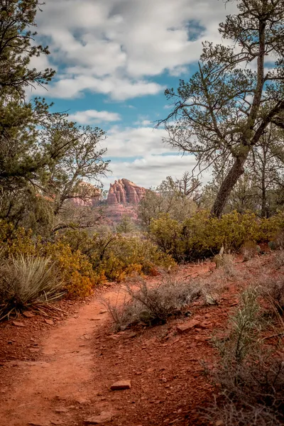
The Baldwin Trail offers a profound departure from the manicured resort landscapes typically associated with the Caribbean. Located on the dramatic eastern coast of Barbados within the parish of St. Joseph, this 8.0 km loop serves as a gateway to the island's most geologically diverse and topographically challenging terrain. Unlike the coral limestone caps that define the rest of the island, the Baldwin Trail traverses the Scotland District—a unique region where ancient sedimentary rocks have been pushed to the surface, creating a landscape of rolling hills, deep gullies, and soaring cliffs. The trail’s primary draw is its ascent toward the legendary Hackleton's Cliff, a massive limestone escarpment that rises nearly 300 metres above sea level, providing walkers with an unparalleled panoramic view of the Atlantic coastline, from the crashing surf of Bathsheba to the distant northern points of the island.
This is a journey through a living museum of Barbadian ecology. The route winds through dense mahogany groves, skirts the edges of traditional agricultural plots, and plunges into humid gullies where the air is thick with the scent of damp earth and tropical flora. It is a moderate challenge that rewards the adventurous with a perspective of Barbados that few tourists ever witness—a world of wild winds, rugged ridges, and the persistent, rhythmic roar of the Atlantic Ocean. Whether you are a seasoned hiker looking for a physical test or a nature enthusiast eager to spot the island's endemic wildlife, the Baldwin Trail delivers a concentrated dose of Caribbean wilderness that is both humbling and exhilarating.
The Baldwin Trail is a masterclass in ecological transition. The walk begins in the relatively sheltered environment of the lower St. Joseph hills, where the vegetation is dominated by sturdy mahogany trees and the occasional silk cotton tree. As the trail progresses, the environment shifts dramatically. The ascent toward the ridge line introduces walkers to the "Bearded Fig Trees" (Ficus citrifolia) that famously gave Barbados its name—"Los Barbados" or "The Bearded Ones"—so named by Portuguese explorers who were struck by the long, hanging aerial roots of these majestic giants. The trail is not merely a path but a corridor through the island's natural history, where the geological struggle between the Caribbean and Atlantic plates is visible in the very soil beneath your feet.
The experience of the Baldwin Trail is defined by its sensory contrasts. In the deep gullies, the wind is silenced, replaced by the high-pitched chorus of whistling frogs and the rustle of green monkeys moving through the canopy. However, as you crest the ridge toward Hackleton's Cliff, the environment transforms. The Atlantic trade winds, which have travelled thousands of kilometres across open water, hit the escarpment with incredible force, providing a cooling—and sometimes buffeting—respite from the tropical sun. The view from the summit is often described as the "finest in the West Indies," offering a vertical drop-off that reveals the intricate patchwork of the Scotland District below, where the land looks more like the Scottish Highlands than a tropical island.
Physically, the trail requires a steady foot and a reasonable level of cardiovascular fitness. While 8.0 km may seem short, the 250-metre elevation gain is concentrated in several steep, switchback sections that can become slippery after the brief, intense rain showers common in the region. The limestone underfoot is often jagged and uneven, demanding concentration. However, the trail is well-trodden and serves as a vital link for local communities, meaning you are as likely to encounter a local farmer tending to a hillside plot as you are a fellow hiker. This intersection of wild nature and local culture adds a layer of authenticity to the Baldwin Trail that makes it a standout experience in the Lesser Antilles.
The history of the Baldwin Trail and the surrounding St. Joseph parish is inextricably linked to the colonial and geological evolution of Barbados. The trail passes through what was once the heart of the island's sugar revolution. In the 17th and 18th centuries, these hills were cleared of much of their original seasonal forest to make way for sugar cane plantations. The Baldwin Trail itself follows routes that were likely used by enslaved labourers and later by free villagers to move between the high cliff-top settlements and the coastal fishing villages. To walk this path is to walk through a landscape of resilience, where the forest has slowly reclaimed the land once dominated by monoculture.
Hackleton's Cliff, the trail's literal and metaphorical high point, holds a special place in Barbadian folklore. Named after a 17th-century landowner, the cliff has served as a navigational landmark for centuries. Local legend tells of various figures who sought refuge in the caves hidden within the cliff face, and the area remains a site of spiritual significance for many. The Scotland District, which the trail overlooks, is the only place in the Caribbean where a portion of the accretionary prism—the pile of sediments scraped off the ocean floor as one tectonic plate slides under another—is exposed above sea level. This makes the Baldwin Trail a site of international geological importance, attracting researchers from around the globe who come to study the unique clay and sandstone formations that are found nowhere else in the region.
Culturally, the trail reflects the "village life" that defines rural Barbados. As you pass near the trailhead and certain ridge sections, you may see small "chattel houses"—traditional wooden homes designed to be moved from one plantation to another. The people of St. Joseph are known for their deep connection to the land, and the Baldwin Trail is a testament to this enduring relationship. The trail is not a commercialised tourist attraction but a piece of the island's living heritage, maintained by the footsteps of those who live and work in its shadow.
Want more background? Read extended notes on history and cultural context → Learn more
Barbados enjoys a tropical climate, but the experience on the Baldwin Trail varies significantly between the dry and wet seasons. Understanding these cycles is crucial for a safe and enjoyable hike.
The Dry Season (December to May): This is widely considered the best time to tackle the Baldwin Trail. During these months, the humidity is lower, and the trade winds are at their most consistent, providing a natural air-conditioning system for hikers. The trail surface is generally firm and dry, making the steep limestone sections much easier to navigate. Visibility from Hackleton's Cliff is often at its peak during the dry season, with the Atlantic horizon appearing sharp and clear. However, the tropical sun is exceptionally strong; even with the breeze, the risk of dehydration and heat exhaustion is high.
The Wet Season (June to November): Also known as the hurricane season, this period brings higher humidity and frequent, heavy tropical downpours. While it rarely rains all day, the showers can be intense, turning the trail's clay-rich soil into a slippery challenge. The landscape, however, is at its most lush and vibrant during this time. The gullies overflow with green life, and the waterfalls (though small) in the surrounding area become more active. Hikers during this season must be prepared for sudden changes in weather and should always check the local forecast for tropical depressions or storm warnings. The heat can feel more oppressive due to the lack of wind during the "doldrums" periods of the wet season.
Temperature and Light: Regardless of the season, temperatures in Barbados remain relatively constant, ranging from 24°C at night to 30°C or higher during the day. On the Baldwin Trail, the temperature can feel several degrees cooler on the ridge due to wind chill, but significantly hotter in the enclosed gullies where air circulation is minimal. Light is also a factor; being close to the equator, Barbados has roughly equal day and night lengths. Sunrise is typically around 06:00, and sunset around 18:00. It is highly recommended to start the Baldwin Trail as close to sunrise as possible to complete the most strenuous climbing before the midday sun reaches its zenith.
Phase 1: The Forested Ascent (Trailhead to Mahogany Grove)
Phase 2: The Ridge Climb (Mahogany Grove to Hackleton's Cliff Summit)
Phase 3: The Cliff-Top Traverse (Hackleton's Cliff to The Northern Lookout)
Phase 4: The Descent and Return Loop (Northern Lookout to Trailhead)
Important Notes:
The Baldwin Trail requires no formal booking or fees, but successful completion depends on careful logistical planning. The most critical factor is transport. The trailhead is located in a rural part of St. Joseph, approximately 30–40 minutes from Bridgetown by car. While public buses (Route 3 or 3A) serve the general area, they can be infrequent, especially on weekends. If using the bus, inform the driver you wish to alight near Hackleton's Cliff and be prepared for a 15-minute walk from the bus stop to the actual trailhead. For those driving, parking is limited to a small gravel area; arrive early to secure a spot.
Physical preparation is also key. While not an alpine trek, the combination of high humidity and steep gradients can be taxing. Ensure you have had a substantial breakfast and are well-hydrated before starting. There are no shops or facilities at the trailhead, so all supplies must be purchased in Bridgetown or at a supermarket along the way (such as those in Warrens or Emerald City).
This is a day hike requiring no overnight accommodation. Camping is not permitted on the Baldwin Trail or within the Hackleton's Cliff area due to the proximity of private land and the fragility of the ecosystem. Most hikers base themselves in the following areas:
If you are looking for a multi-day experience, consider booking accommodation in Bathsheba and using the Baldwin Trail as one of several day hikes in the St. Joseph and St. Andrew parishes.
Currently, no permits are required to hike the Baldwin Trail. It is a public access route that traverses a mix of Crown land and traditional rights-of-way. However, hikers should be aware of the following "unwritten" rules of the trail:
While the trail is free to use, many hikers choose to join an organised walk with the Barbados National Trust. They host regular Sunday morning hikes across the island, including the Baldwin Trail area. These hikes often include a small donation fee (approx. 20 BBD) which goes toward the preservation of the island's natural and architectural heritage. This is an excellent way to learn about the history and botany of the trail from expert local guides.


Precisely traced GPX for the Baldwin Trail, ready for your GPS or favourite mapping app.
The St. Joseph parish is the "green heart" of Barbados, offering several world-class attractions within a short drive of the Baldwin Trail:
Heat and Hydration: The single greatest risk on the Baldwin Trail is heat exhaustion. The combination of 30°C temperatures and high humidity can lead to rapid dehydration. Drink water regularly, even if you do not feel thirsty. If you begin to feel dizzy, nauseous, or develop a headache, find shade immediately and rest. This is why an early start is non-negotiable for most hikers.
Terrain Hazards: The limestone on the ridge is "karst" topography—it is sharp, uneven, and can have hidden holes covered by grass. Watch your step carefully. During the wet season, the clay sections of the trail become incredibly slick, resembling "greased glass." Take small steps and use trekking poles for balance. Avoid the very edge of Hackleton's Cliff, especially in high winds; the rock can be unstable, and there are no guardrails.
Flora and Fauna: Barbados has very few dangerous animals, but there are things to watch for. The Manchineel tree (Hippomane mancinella) is found in some coastal areas, though less common on this specific high-altitude trail. Its sap and fruit are highly toxic and can cause severe skin blisters. If you see a tree with small green "apples" and a red band painted on the trunk, do not touch it. The Centipede (Scolopendra) can deliver a painful bite; avoid sticking your hands into dark crevices or under rotting logs. Green monkeys are generally shy but can be protective of their young; do not attempt to feed or approach them.
Emergency Contacts: In the event of an emergency, dial 211 for police, 511 for fire, or 311 for ambulance services. Be prepared to give your location relative to Hackleton's Cliff or the nearest village (such as Horse Hill or Castle Grant).
The "Secret" Caves: Along the base of the limestone escarpment, there are several small caves and overhangs used by locals for centuries. While some require technical climbing gear, others are accessible via short, steep scrambles from the main trail. These caves offer a cool retreat and a glimpse into the island's geological plumbing system.
Cotton Tower: A short detour from the northern end of the trail leads to Cotton Tower, one of the historic signal stations built by the British in the early 19th century. These towers were used to communicate across the island using semaphores. While the tower itself is often closed to the public, the grounds offer a fantastic historical context to the landscape you are walking through.
The Chalky Mount Potteries: If you have a car, a 10-minute drive from the trailhead takes you to Chalky Mount, where local potters still use the unique clays of the Scotland District to create traditional Barbadian "monkeys" (water jugs) and other wares. It is a fascinating look at how the geology of the trail supports a centuries-old craft.
Blackmans Gully: For those who want more "jungle" vibes, the nearby Blackmans Gully offers a shorter, flatter walk under a dense canopy of ancient trees and giant ferns. It is a perfect cool-down walk after the exertion of the Baldwin Trail.
The Baldwin Trail passes through some of the last remaining semi-natural habitats in Barbados. With the island's high population density, these "wild" spaces are under constant pressure. As a hiker, you play a crucial role in their preservation.
Leave No Trace Principles for the Baldwin Trail: