
Ausangate Circuit: A High-Altitude Andean Adventure
The Ausangate Circuit is a challenging multi-day trek in the Peruvian Andes, circling the sacred Mount Ausangate, one of the most revered peaks in Inca mythology. This remote and rugged trail takes walkers through a landscape of dramatic glacial lakes, vast puna grasslands, and high mountain passes, offering an unparalleled immersion into the raw beauty of the Andes. Unlike more frequented routes, the Ausangate Circuit provides a genuine sense of solitude and an authentic cultural experience, passing through traditional Quechua villages where ancient customs persist.
- Distance: 63.0 km
- Duration: 5-7 days
- Season: May to September (dry season)
- Elevation Gain: 4800 m
- Highest Point: Approximately 5,200 m (various passes)
- Difficulty: Challenging
- Closest City: Cusco
- Trailhead Access: From Cusco, travel to Tinqui (approx. 3-4 hours by bus/taxi)
- Permits: Not required for the trail itself, but local community registration is recommended
Overview
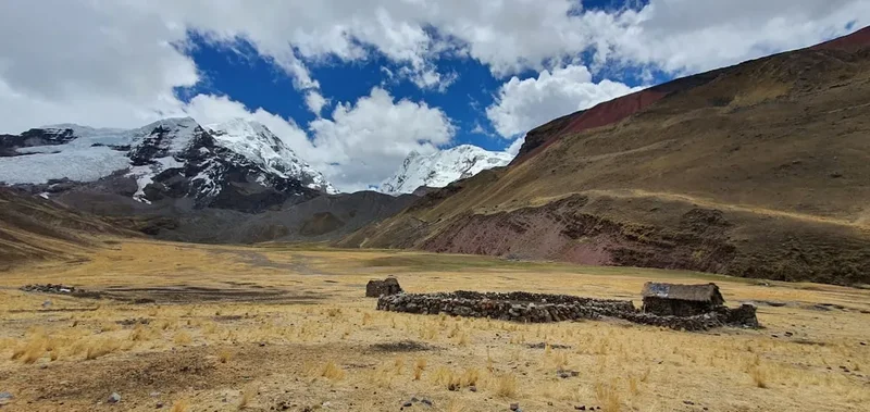
The Ausangate Circuit is a trek that truly tests the limits of endurance and spirit, rewarding those who undertake it with breathtaking vistas and a profound connection to the Andean wilderness. The trail circumnavigates the imposing Mount Ausangate (6,384 m), a sacred mountain (Apu) considered a deity by the Inca and still revered by the local Quechua people. This journey is not merely a physical challenge; it is a spiritual pilgrimage through a landscape imbued with ancient beliefs and traditions.
The trek typically spans five to seven days, allowing ample time to acclimatise to the extreme altitudes, which frequently exceed 4,500 metres and reach over 5,000 metres at several high passes. Each day presents a new spectacle: turquoise glacial lakes reflecting snow-capped peaks, vast expanses of golden puna grass dotted with grazing alpacas and llamas, and the stark, majestic beauty of the Ausangate massif itself. The air is thin and crisp, the silence profound, broken only by the wind or the distant bleating of sheep.
The route passes through remote Quechua communities, offering a rare glimpse into a way of life that has remained largely unchanged for centuries. You will encounter local farmers tending their fields, women weaving vibrant textiles, and children playing in the shadow of colossal mountains. This cultural exchange is as significant as the natural beauty, providing a deeper understanding of the people who call this harsh yet beautiful land home.
The Ausangate Circuit is a demanding trek due to its high altitude, unpredictable weather, and rugged terrain. It requires a good level of physical fitness, prior trekking experience, and careful preparation. However, for those seeking an authentic, off-the-beaten-path Andean adventure, the Ausangate Circuit offers an unforgettable experience, a true immersion into the heart of the Andes.
History and Cultural Context
The Ausangate region has been a sacred landscape for millennia, deeply intertwined with the spiritual beliefs of the indigenous peoples of the Andes. For the Inca, Mount Ausangate was one of the most powerful Apus (mountain deities) in their cosmology, believed to be a source of life, fertility, and protection. Legends speak of Ausangate as a brother to the great mountain Machu Picchu, and as a protector of the Cusco region. The Inca performed elaborate rituals and ceremonies at Ausangate, offering sacrifices to ensure good harvests and favourable weather.
The Quechua communities living in the Ausangate region today continue to honour these ancient traditions. Their lives are inextricably linked to the land and the mountain. They practice traditional agriculture, herding llamas and alpacas, and maintaining a deep spiritual connection to the natural world. The Ausangate Circuit passes through villages where these traditions are still very much alive, offering trekkers a unique opportunity to witness a way of life that has endured for centuries, largely untouched by modern influences.
The concept of the "Ausangate Circuit" as a defined trekking route is relatively recent, emerging with the growth of adventure tourism in Peru. However, the paths themselves are ancient, used by local communities for generations to travel between villages, herd livestock, and access high-altitude pastures. The trek follows these traditional routes, providing an authentic experience that goes beyond mere sightseeing.
The region's remoteness has preserved its cultural and natural heritage. Unlike more accessible areas, Ausangate has not been significantly altered by colonial or modern development, allowing its ancient spiritual significance and pristine landscapes to remain intact. This makes the Ausangate Circuit a journey not just through mountains, but through time and living history.
Seasonal Highlights and Weather Reality
The Ausangate Circuit is best undertaken during the dry season, which typically runs from May to September. This period offers the most stable weather conditions, with clear skies and minimal rainfall, making it ideal for high-altitude trekking.
Dry Season (May to September):
- May & June: The beginning of the dry season. Days are generally sunny and clear, with temperatures ranging from cool to cold. Nights can be very cold, often dropping below freezing, especially at higher elevations. The landscape is often vibrant with autumn colours.
- July & August: These are the coldest and driest months. Daytime temperatures are pleasant in direct sunlight, but the air is crisp and cold. Nights are consistently below freezing, and frost is common. This is peak season for trekking due to the reliable weather.
- September: The end of the dry season. Weather remains generally good, though there's a slight increase in the chance of rain towards the end of the month. Temperatures are similar to July and August.
Wet Season (October to April):
- This period is characterised by heavy rainfall, particularly in the afternoons. Roads can become impassable, and trekking conditions are significantly more challenging due to mud, slippery trails, and reduced visibility. Snowfall is also more frequent at higher elevations. While some hardy trekkers may attempt the circuit during this time, it is generally not recommended due to the increased risks and discomfort.
Weather Considerations:
Even during the dry season, the weather in the Andes can be unpredictable. High altitudes mean that conditions can change rapidly. Expect strong winds, especially at the high passes, and be prepared for sudden drops in temperature. Daytime temperatures can be warm in direct sunlight, but shade and wind can make it feel much colder. Nights are always cold, and frost is common. Altitude sickness is a significant concern, and acclimatisation is crucial.
Recommended Itinerary
5-Day Ausangate Circuit Itinerary (Sample)
Day 1: Cusco to Tinqui (Trailhead) & Trek to Upis
- Distance: Approximately 8 km
- Elevation Gain: ~300 m
- Time: 3-4 hours trekking
- Morning: Depart Cusco by private vehicle or bus to Tinqui (approx. 3-4 hours).
- Afternoon: Begin trekking from Tinqui, a small Andean village. The trail is relatively gentle, passing through agricultural lands and small hamlets.
- Arrive at Upis (4,400 m), a campsite near hot springs.
- Set up camp and enjoy the first views of Ausangate.
Day 2: Upis to Arapa Pass & Hatun Pampa
- Distance: Approximately 12 km
- Elevation Gain: ~600 m to pass, ~300 m descent
- Time: 6-7 hours
- Morning: Ascend towards Arapa Pass (approx. 4,800 m). This is a significant climb, and acclimatisation is key.
- Cross Arapa Pass, offering panoramic views of the Ausangate massif and surrounding valleys.
- Descend to Hatun Pampa (approx. 4,500 m), a wide, scenic camping area.
- Enjoy the vastness of the puna landscape.
Day 3: Hatun Pampa to Ausangate Lake & Palccoyo
- Distance: Approximately 15 km
- Elevation Gain: ~500 m to pass, ~400 m descent
- Time: 7-8 hours
- Trek towards the stunning Ausangate Lake (Laguna Ausangate), a vibrant turquoise glacial lake.
- Continue to another high pass (approx. 4,900 m), offering incredible views of Ausangate's glaciers.
- Descend towards the Palccoyo area (approx. 4,500 m), known for its colourful mountains.
- Set up camp in a scenic location.
Day 4: Palccoyo to Q'ampa Pass & Chillca
- Distance: Approximately 14 km
- Elevation Gain: ~600 m to pass, ~400 m descent
- Time: 7-8 hours
- Ascend to Q'ampa Pass (approx. 5,050 m), one of the highest points on the circuit.
- The views from this pass are spectacular, with glaciers and snow-capped peaks dominating the horizon.
- Descend into the valley towards Chillca (approx. 4,600 m), a traditional Quechua village.
- Opportunity to interact with locals and experience their way of life.
- Camp near the village.
Day 5: Chillca to Tinqui & Return to Cusco
- Distance: Approximately 15 km
- Elevation Gain: ~200 m, ~500 m descent
- Time: 5-6 hours
- Gentle trek back towards Tinqui, following the valley floor.
- The trail offers final views of Ausangate and the surrounding mountains.
- Arrive back in Tinqui, where transport will be waiting.
- Drive back to Cusco (approx. 3-4 hours).
Important Notes:
- This is a sample itinerary; durations and daily distances can be adjusted based on group fitness and acclimatisation.
- A 6-7 day itinerary would allow for more relaxed pacing and additional acclimatisation days.
- All camping is wild camping; no designated campsites or facilities exist.
- A support vehicle or pack animals (mules/horses) are highly recommended for carrying gear.
- This trek requires significant acclimatisation in Cusco (minimum 2-3 days) before starting.
Planning and Bookings
Book Your Trip
Everything you need to plan your journey
Accommodation
Find places to stay near Cusco
Flights
Search flights to Cusco
Essential Preparation
The Ausangate Circuit is a high-altitude trek that demands thorough preparation. The closest major city is Cusco, which serves as the primary gateway for all treks in the region. It is crucial to spend at least 2-3 days in Cusco (altitude approx. 3,400 m) for acclimatisation before commencing the trek. This allows your body to adjust to the lower oxygen levels, significantly reducing the risk of altitude sickness.
Logistics for the Ausangate Circuit typically involve arranging transport from Cusco to the trailhead in Tinqui. This can be done via shared tourist buses, private taxis, or organised trekking tours. For a trek of this nature, it is highly recommended to book with a reputable trekking agency. They will handle transport, permits (if any local community fees apply), experienced guides, cooks, and pack animals (mules or horses) to carry your gear, which is essential given the remote nature of the trek and the need to carry camping equipment and food.
Fitness is paramount. The trek involves long days of walking at high altitudes, with significant ascents and descents over rugged terrain. A good level of cardiovascular fitness, combined with strength training for legs and core, is essential. Prior experience with multi-day trekking, especially at altitude, is highly beneficial.
Trail Accommodation
This is a remote, high-altitude trek that requires wild camping. There are no established huts, lodges, or campsites along the Ausangate Circuit. Trekkers must be self-sufficient and carry all necessary camping equipment, including tents, sleeping bags, and cooking gear.
Accommodation: Wild camping in designated areas or suitable flat ground. Campsites are typically chosen for their proximity to water sources and shelter from the wind. Popular camping spots are often near traditional villages or scenic points like glacial lakes.
Facilities Provided: None. Trekkers must be entirely self-sufficient.
What's NOT Provided: All camping facilities, including tents, sleeping mats, sleeping bags, cooking equipment, food, water treatment, and sanitation facilities. There are no toilets, running water, or electricity.
Seasonal Availability: Camping is possible year-round, but the dry season (May to September) is strongly recommended for safety and comfort due to more predictable weather and less rainfall.
Costs: While there are no direct accommodation fees for camping, the cost is embedded within the overall trekking package, which includes guides, porters/mules, food, and transport. Local community entrance fees may apply in some areas, typically paid directly to village leaders.
This is a multi-day trek requiring overnight camping. No permanent accommodation exists on the trail.
Required Gear
- Sturdy Hiking Boots: Waterproof, broken-in, with good ankle support. Essential for navigating rocky and uneven terrain at high altitudes.
- Waterproof Jacket and Trousers: High-quality, breathable, and fully waterproof. Weather can change rapidly, and rain or snow is possible even in the dry season.
- Warm Layers: Multiple layers are crucial. Include thermal base layers (merino wool or synthetic), fleece mid-layers, and an insulated down or synthetic jacket for warmth.
- Sleeping Bag: A 4-season sleeping bag rated to at least -10°C to -15°C is recommended due to freezing night temperatures at altitude.
- Sleeping Mat: Insulated mat for warmth and comfort.
- Backpack: A comfortable trekking backpack (50-70 litres) with a rain cover. If using pack animals, a smaller daypack (20-30 litres) is sufficient for daily essentials.
- Head Torch: With spare batteries. Essential for navigating camp in the dark and for early morning starts.
- Sun Protection: High SPF sunscreen, lip balm with SPF, sunglasses (with UV protection), and a wide-brimmed hat or cap. The sun is intense at high altitudes.
- First-Aid Kit: Comprehensive kit including blister treatment, pain relievers, antiseptic wipes, bandages, personal medications, and altitude sickness medication (e.g., Diamox, consult your doctor).
- Trekking Poles: Highly recommended for stability on ascents and descents, and to reduce strain on knees.
- Navigation Tools: GPS device or reliable offline map app on a smartphone, compass, and physical map. Guides will have these, but it's good practice to have your own.
What to Bring
- Food: All meals and snacks for the duration of the trek. This typically includes breakfast, lunch, dinner, and high-energy snacks like nuts, dried fruit, energy bars, and chocolate. Trekking agencies usually provide this, but confirm details.
- Water Treatment: Water filter, purification tablets, or UV steriliser. While water sources are generally available, treating all water is essential to prevent gastrointestinal issues.
- Toiletries: Biodegradable soap, toothbrush and toothpaste, toilet paper (pack out used paper), hand sanitiser, and any personal hygiene items.
- Personal Items: Camera, power bank for electronics, book or journal, small towel.
- Clothing: Several pairs of hiking socks (wool or synthetic), comfortable camp clothes (e.g., fleece trousers, warm jumper), gloves (warm and waterproof), beanie or warm hat.
- Duffel Bag: If using pack animals, a sturdy, waterproof duffel bag (80-100 litres) for your main gear.
- Small Backpack: For day use, carrying water, snacks, camera, rain gear, and first-aid essentials.
- Cash: Peruvian Soles for local purchases, tips for guides and porters, and any unexpected expenses.
Permits

The Ausangate Circuit itself does not require specific national park permits in the same way as some other famous treks. However, the region is inhabited by indigenous Quechua communities, and trekkers often pass through their lands and villages. It is customary and highly recommended to pay a small community fee or contribution upon entering certain areas or villages. This fee supports the local communities and is often collected by village elders or designated representatives.
Community Fees: These fees are typically modest (e.g., 10-20 Peruvian Soles per person) and are usually arranged by trekking agencies. If travelling independently, it is advisable to inquire locally about any required contributions. These fees are not formal permits but rather a gesture of respect and support for the local people whose land you are traversing.
Booking Requirements: While no advance booking is required for the trail itself, it is essential to book your trekking services (guide, transport, pack animals) well in advance, especially if travelling during the peak dry season (June to August). Reputable trekking agencies in Cusco will handle all logistical arrangements, including any necessary community contributions.
Independent Trekkers: If you choose to trek independently, ensure you have a detailed map, a reliable GPS device, and are prepared for all self-sufficiency requirements. It is still advisable to inform yourself about local customs and any community fees that may be applicable.
Other Activities in the Area
While the Ausangate Circuit is the primary draw, the region offers several other enriching experiences:
- Rainbow Mountain (Vinicunca): A popular day trip or overnight excursion from Cusco, this vibrantly coloured mountain is a geological marvel. It can be combined with a visit to the Red Valley.
- Palccoyo Rainbow Mountains: A less crowded alternative to Vinicunca, offering multiple colourful mountains and stunning views of Ausangate. Often visited as part of the Ausangate trek itself.
- Hot Springs: Several natural hot springs are found in the Ausangate region, such as those near Upis. These offer a welcome opportunity to relax and soak weary muscles amidst spectacular scenery.
- Cultural Immersion: Spending time in the traditional Quechua villages along the route provides invaluable insight into local life, customs, and traditional weaving techniques. Engaging respectfully with the local communities is a highlight for many trekkers.
- Photography: The dramatic landscapes, vibrant colours, unique wildlife (llamas, alpacas, condors), and traditional village life offer endless photographic opportunities.
- Stargazing: With minimal light pollution at high altitudes, the night skies in the Ausangate region are incredibly clear and offer spectacular views of the Milky Way and constellations.
Safety and Conditions
Altitude Sickness (Soroche): This is the most significant risk on the Ausangate Circuit. Symptoms can include headache, nausea, dizziness, fatigue, and shortness of breath. Prevention is key: acclimatise properly in Cusco for 2-3 days, ascend gradually, stay hydrated, avoid alcohol and heavy meals, and consider altitude medication (consult your doctor). If symptoms worsen, descend immediately.
Weather: Conditions at high altitudes are unpredictable and can change rapidly. Be prepared for strong winds, freezing temperatures, rain, sleet, and snow, even during the dry season. Hypothermia is a serious risk. Always carry appropriate layers and waterproof gear.
Terrain: The trail is rugged, rocky, and often steep. High passes can be exposed and challenging. Trekking poles are highly recommended for stability and to reduce strain on joints. Ensure your hiking boots are well-maintained and provide good grip.
Remoteness: The Ausangate Circuit is a remote trek with limited access and no facilities. Medical assistance is far away. It is crucial to be self-sufficient and carry a comprehensive first-aid kit. Hiring experienced guides and porters is strongly advised for safety and logistical support.
Water Sources: While water is generally available from streams and glacial melt, it must be treated before consumption to avoid waterborne illnesses. Always carry a reliable water filter or purification tablets.
Wildlife: While generally not dangerous, be aware of your surroundings. Llamas and alpacas are common. Keep a respectful distance from all wildlife.
Communication: Mobile phone signal is non-existent for most of the trek. Consider carrying a satellite communication device (e.g., Personal Locator Beacon - PLB) for emergencies.
Travel Insurance: Ensure your travel insurance covers high-altitude trekking and emergency evacuation. This is non-negotiable for a trek of this nature.
Side Trips and Points of Interest
Laguna Ausangate: A breathtakingly beautiful glacial lake, often a vibrant turquoise or emerald green, situated at high altitude. Its pristine waters reflect the surrounding snow-capped peaks, including the imposing Ausangate massif. It's a popular camping spot and a highlight for photographers.
Hot Springs of Upis: Located near the village of Upis, these natural thermal springs offer a therapeutic soak after a day of trekking. The warm waters are a welcome respite from the cold mountain air, and the setting amidst the Andean landscape is spectacular.
Q'ampa Pass (approx. 5,050 m): One of the highest points on the circuit, this pass offers unparalleled panoramic views. From here, you can often see vast glaciers, snow-covered peaks, and the expansive puna landscape stretching out below. It's a challenging but incredibly rewarding section of the trek.
Traditional Quechua Villages: The circuit passes through several small, remote villages where traditional Quechua culture is still very much alive. Observing the daily lives of the villagers, their farming practices, and their vibrant textiles offers a unique cultural experience. Villages like Chillca are known for their welcoming atmosphere.
Rainbow Mountains (Palccoyo): While often visited as a separate excursion, the Palccoyo range, with its distinct bands of colour, can sometimes be viewed or accessed from certain points along the Ausangate Circuit, depending on the exact route taken. These mountains are a geological wonder, showcasing mineral deposits that create stripes of red, yellow, green, and purple.
Leave No Trace
The Ausangate region is a pristine wilderness and a sacred landscape for the local Quechua people. Adhering to Leave No Trace principles is paramount to preserving its natural beauty and cultural integrity for future generations.
Plan Ahead and Prepare: Understand the challenges of high-altitude trekking, weather conditions, and remoteness. Pack appropriately and be self-sufficient. Inform someone of your itinerary.
Travel and Camp on Durable Surfaces: Stick to established trails where they exist. When camping, choose established sites or durable surfaces like rock or dry grass, away from water sources. Avoid trampling vegetation.
Dispose of Waste Properly: Pack out everything you pack in, including all food scraps, wrappers, and toilet paper. Use designated toilet facilities where available (rare on this trek) or dig catholes at least 60 metres away from water, camp, and trails. Pack out all human waste and toilet paper.
Leave What You Find: Do not remove any natural objects (rocks, plants) or cultural artefacts. Respect the sacred nature of the landscape and its historical significance.
Minimise Campfire Impacts: Campfires are generally not permitted or advisable in this fragile environment due to the risk of wildfires and the scarcity of fuel. Use a lightweight stove for cooking.
Respect Wildlife: Observe wildlife from a distance. Do not feed animals, as this can disrupt their natural behaviours and diets. Store food securely to prevent attracting animals.
Be Considerate of Other Visitors: While the Ausangate Circuit is remote, you may encounter local communities or other trekkers. Maintain a respectful distance, keep noise levels low, and be mindful of local customs and traditions.
By following these principles, you help ensure that the Ausangate Circuit remains a wild and sacred place for all to experience.